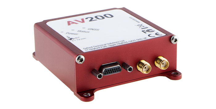
OxTS has released the AV200, its inertial navigation system (INS) built for automation applications.
The AV200 is designed to reliably give precise location data. It includes quad-constellation, dual-antenna, real-time kinematic (RTK) GNSS, to provide users with position data as well as its temperature-calibrated, multi-core inertial measurement unit. These technologies give the AV200 position accuracy within 0.05 m, heading accuracy of 0.2°, and velocity accuracy of 0.2 km/h.
The AV200 is built using the same technology that is commonly used for NCAP test validation, which has become the preferred technology for OEMs globally to test vehicles in both test-track and real-world scenarios.
The AV200 has also been built specifically to address the realities of the autonomy market.
Singular XYZ has released the Sfaira One GNSS receiver. The portable size, centimeter-accurate receiver provides users with an entry-level network real time kinematic (RTK) rover.
Sfaira One is equipped with a GNSS module with 1,408 channels for GPS, BDS, GLONASS, Galileo and QZSS tracking — providing centimeter positioning in harsh environments. It also features advanced RTK and an anti-interference algorithm.
The GNSS receiver connects via Bluetooth and can be configured to conduct surveying tasks on a smartphone. Additionally, Sfaira One supports SingularPad and SingularSurv software and is also compatible with mainstream field survey or GIS software.
Sfaira One is IP65 dustproof and waterproof, which makes the receiver suitable for all weather conditions. It has a 4,800 mAh battery life with 16 hours working time and type-C interface that can be charged on-the-go with power bank.
The Sfaira One GNSS receivers are online at SingularXYZ’s website and are available now.
Trimble has released the PX-1 RTX for accurate and robust positioning and heading for commercial UAV delivery applications. This positioning solution enables UAV integration companies to add precise positioning capabilities so that operators can plan and execute takeoff, navigation and landing tasks as UAV delivery advances to take on more challenging operations.
The PX-1 RTX leverages Trimble’s CenterPoint RTX corrections and small, high-performance GNSS-inertial hardware to provide real-time, centimeter-level positioning and accurate inertial-derived true heading measurements. This solution allows operators precise control of UAVs during takeoff and landing to tackle more demanding operations in tight or partially obstructed spaces.
It also minimizes operational risks from poor sensor performance or magnetic interference by ensuring greater positioning redundancy, which is especially important as commercial UAV delivery operations venture into difficult urban and suburban environments.
The Trimble PX-1 RTX solution is available through Trimble Applanix sales channels. For more information click here.
The launch will be held at XPONENTIAL. Visit Trimble at Booth 1806 to learn more.
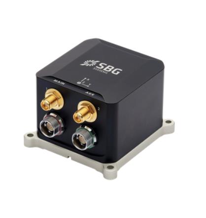
SBG Systems has released the Ekinox Micro, a compact and rugged high-performance inertial navigation solution designed to deliver accuracy in challenging environments. Ekinox Micro combines a high-performance MEMS tactical inertial sensor with a quad-constellation, dual-antenna GNSS receiver, making it suitable for mission-critical applications.
Ekinox Micro includes pre-configured motion profiles for land, air, and marine applications, enabling the sensor and algorithms to be tuned for maximum performance in any condition. The device is designed for ease of use and integration, with simple connectors, a web configuration interface, a datalogger, Ethernet connectivity, a PTP server, a REST API for configuration, and multiple input and output formats.
Ekinox Micro is real-time kinematic (RTK) compatible and based on a tactical 0.8°/h class inertial measurement unit calibrated across the entire operating temperature range. It features accuracy roll/pitch of 0.015°, accuracy heading of 0.035°, and accuracy position of 1.2 m without any corrections or 1 cm in RTK.
Septentrio has signed a distribution partnership with Braemac for North America and Mexico. Braemac will distribute the full Septentrio portfolio including the compact mosaic module family, OEM boards, GNSS enclosures and GNSS/INS solutions for demanding industrial applications.
Braemac distributes electronic components in the North American market and offers GNSS antennas, wireless connectivity solutions and other products, which are complementary to the Septentrio portfolio.
Septentrio’s advanced GNSS chipset and proprietary algorithms provide consistent pinpoint accuracy for its receivers. The built-in advanced interference mitigation technology ensures resilience to GNSS jamming and spoofing, making Septentrio’s GNSS and GNSS/INS receivers a suitable positioning component in any robotic, UAV or machine control system.
Septentrio will be exhibiting at the AUVSI XPONENTIAL conference in Denver, Colorado, on May 9 -11 at booth 4912. On Tuesday May 9, GNSS experts from Septentrio as well as other UAV integrators will share their experience in the panel discussion about “The Importance of GNSS Security in UAV Applications”.
On May 3, Russia claimed Ukraine had launched an overnight UAV attack on the Kremlin in an effort to assassinate President Vladimir Putin, reported multiple news sources including NBC News and Reuters. President Volodymyr Zelenskiy quickly denied any Ukrainian involvement.
A video taken of the incident posted on social media shows two UAVs aimed at the Kremlin that were promptly shot down.
A Ukrainian official stated the incident suggested Moscow was preparing a major terrorist provocation, reported Reuters. Putin’s office said Russia reserved the right to retaliate and that it regards the incident as a planned act of terrorism and an attempt on the president’s life.
A Russian agency also stated Putin was not at the Kremlin at the time of the incident.
BREAKING: Footage surfaces of Ukrainian drone strike on the Kremlin last night. Russian govt confirms 2 unmanned aircraft downed by electronic-warfare systems after crashing into the Kremlin. Tensions escalate amid #UkraineRussiaWar️, inching closer to WW3. #KremlinStrike… pic.twitter.com/RdOHmcsh5k
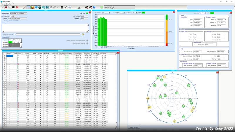
Syntony GNSS and Xona Space Systems have partnered to integrate the low-Earth-orbit (LEO) position, navigation and timing (PNT) constellation from Xona into GNSS simulators and receiver solutions from Syntony.
This partnership is part of Syntony’s and Xona’s strategy to offer users PNT solutions.
“The demand for advanced and resilient PNT services is skyrocketing,” Brian Manning, CEO of Xona Space Systems, said. “We are building an entire ecosystem from the ground up to address this demand. Having a full Rx-Tx solution available for all Xona signals is one of the keys to rapidly develop this LEO PNT ecosystem.”
Syntony GNSS was the first PNT services provider to integrate all of the Xona demo signals into its multi-GNSS simulation solution, Constellator, in 2022. However, to offer a full testing solution, Syntony has also developed a Xona-enabled GNSS receiver.
The latest versions of Ekinox, Apogee, and Navsight from SBG Systems are now fully compatible with the Fugro Marinestar G4+ precise point positioning (PPP) solution.
Fugro Marinestar G4+ is a solution that uses satellite-based augmentation to deliver centimetric positioning accuracy without depending on a local base station. This product is suitable for maritime operations where precise positioning is important.
With this compatibility, users can now use Marinestar correction with SBG products both via L-Band or NTRIP distribution.
The combination of high-performance correction with inertial measurements from SBG Systems enables users to achieve accuracy in attitude and position for maritime applications. This is suitable for applications such as marine construction, dredging, hydrography and more.
“Seen & Heard” is a monthly feature of GPS World magazine, traveling the world to capture interesting and unusual news stories involving the GNSS/PNT industry.
Image: Apple
Apple Products Meet Accuracy with GPS
Apple launched the Ultra Watch, which contains a dual-frequency GPS antenna that can receive L5 signals, as well as the iPhone 14, which features a dual-band GPS receiver combining the L1 and L5 signals. The company is also harnessing signals from more than 70 satellites to boost the accuracy of its services such as SOS alerts and alerting emergency responders, per The National News. The dual-frequency abilities of the new products provide accurate location for calculating distance, pace and routes. The L5 signals also are a critical component of Apple’s health and safety features, providing more accuracy than in previous products.
Wildlife researchers in Key Largo, Florida, accidently discovered a way to locate and eradicate invasive Burmese pythons, per WFLA News Channel 8. The team of researchers were observing racoons and possums that were fitted with tracking collars to note their behavior. After months of observation, a possum collar sent a mortality signal due to lack of movement. To the researchers’ surprise, the collar then started moving again. They later discovered the possum had been eaten by a python. While this was not the intent of the team’s research, they proved this could be an effective way to lower the increasing population of the invasive python species.
Scientist Liu Shaochuang and his team have used satellite remote-sensing technology to study and track wild camels. Shaochuang studies the interrelationship between endangered animals and their environments, which may help protect the species against climate change. To track a camel, Shaochuang attaches a GNSS-enabled collar, which transmits the camel’s location every day. The short message function is provided by China’s BeiDou satellite system, which transmits and receives signals in real time. Based on the data, Shaochuang and his team can observe migratory paths, living environments and possible threats.
Image: Screenshot of CNN video
Former South Carolina Attorney Convicted with Location Data
On March 3, Alex Murdaugh was convicted of killing his son Paul Murdaugh and wife Maggie Murdaugh. With limited evidence, the prosecution used a phone video and vehicle navigation data to prove Alex’s guilt. During the trial, Alex claimed he was visiting his mother during the time the murders took place. However, General Motors OnStar data accessed by investigators from his Chevrolet Suburban contradicted the alibi, putting Alex at the scene of the crime during the time of the murders. Plus, in a smartphone video taken by Paul that night, Alex’s voice could be heard, placing him at the scene.
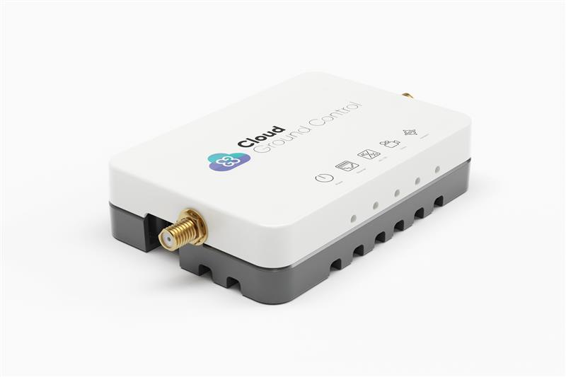
Credit: Cloud Ground Control by Advanced Navigation
Cloud Ground Control, an Advanced Navigation company, has released its cellular micro-modem, the CGConnect. Using 4G/5G networks, CGConnect links UAVs or robotic vehicles to Cloud Ground Control’s cloud-based UAV fleet management platform — enabling live-streaming, command and control from a web browser.
CGConnect can securely connect UAVs and vehicles into one autonomous fleet across land, sea and air, regardless of manufacturer or model. This provides mission planners and operators with full situational awareness for search and rescue, emergency response and disaster relief.
Artificial intelligence (AI) algorithms run in the cloud, relaying real-time camera feed data to the end user to support missions such as object detection, tracking and thermal imaging. The flexible and customizable open platform operates on industry standards, which multiplies potential product applications and enables autonomous vehicles and payloads to operate as a coordinated fleet.
CGConnect’s high-grade security safeguards data and IP from vulnerabilities and security breaches, helping users meet compliance obligations. Additionally, CGConnect supports edge AI to perform intensive object identification and classification directly on the vehicle for dynamic missions.
CGConnect is available for pre-order. An OEM option is also available.
Lt. Col. Robert O. wray commands the 2nd Space Operations Squadron (2 SOPS), which operates GPS around the clock supplemented by members of the 19th Space Operations Squadron (19 SOPS). (Credit: U.S. Space Force photo by Dennis Rogers)
Exclusive GPS World interview with the commander of the unit that operates the GPS constellation
The entire Global Positioning System constellation comprised of 38 satellites — with its billions of users and myriad military, commercial, consumer and scientific applications — is controlled from one room in a gray office building on a small military base about nine miles east of Colorado Springs, Colorado. The base is Schriever Space Force Base (SFB) and the room is the “operations floor” of the GPS Master Control Station (MCS). It is staffed by members of the 2nd Space Operations Squadron (2 SOPS), an active-duty unit of the U.S. Space Force, supplemented by members of the 19th Space Operations Squadron (19 SOPS), a unit of the U.S. Air Force Reserve. The two squadrons are known collectively as “Team Blackjack.”
Lt. Col. Robert O. Wray is the commander of 2 SOPS and of those 19 SOPS members assigned to the MCS. On March 16, at Schriever SFB, Wray spoke at length with GPS World’s editor-in-chief, Matteo Luccio, about the training and duties of his team members, the challenges they face, and what brought him to his current assignment. He then gave Luccio a tour of the MCS and introduced him to each of the 10 people on duty. At any given time, eight of these operators are military personnel and two are civilian contractors. They receive feeds from a worldwide network of monitor stations and ground antennas, including telemetry from the satellites, that enable them to precisely monitor the satellites’ orbits and the state of their systems. The operators upload data and commands to the satellites around the clock to keep the constellation fine-tuned and respond to changing circumstances.
An abridged version of the interview will appear in the May issue of GPS World. A longer version will appear here on May 1.
The European Space Agency (ESA) and the One Sea Association — a non-profit global alliance of commercial manufacturers, integrators and operators of maritime technology, digital solutions, and automated and autonomous systems — are partnering to promote the development of space-enabled services that aim to support the maritime sector’s transition to autonomous shipping.
This partnership will combine expertise in the maritime sector and in autonomous shipping from One Sea with technical competence and mandate through the Business Applications and Space Solutions program from ESA to support the development and demonstration of space solutions in addressing user needs.