SPH Engineering and Radar Systems, Inc. have developed the Zond Aero 500 NG, a versatile ground penetrating radar (GPR) system designed for both terrestrial and drone-mounted surveys. This dual-purpose GPR is suitable for various applications, including utility scanning, sinkhole detection, glaciology and geological studies.
The Zond Aero 500 NG features dual-mode operation, allowing users to conduct both ground-based and airborne surveys. This flexibility enhances the data collection methods available to operators. The system includes a center frequency of 500 MHz, an operating bandwidth of 200-900 MHz (-12 dB), a sampling rate of 25,600 samples per second and a scan rate of 50 scans per second. It can achieve depth penetration of up to 4 m in average soil conditions, making it effective for a range of subsurface investigations.
It is designed to deliver high-quality data through advanced electronics and real-time to enhance the signal-to-noise ratio significantly. This improvement enables the detection of finer details and deeper anomalies within the surveyed area. Additionally, the system is compatible with DJI Matrice 300/350 UAVs for airborne applications.
The system’s data is recorded in real time as radiolocation profiles (radargrams), which are stored for further processing and interpretation. The data is saved in the standard geophysical SEGY format (.sgy) with geotagging for each trace to offer accurate analysis and reporting.
The European Union Agency for the Space Programme (EUSPA) has awarded GMV a six-year framework contract to upgrade the European GNSS Service Centre (E-GSC) infrastructure. The contract is valued at €35 million ($39 million).
The E-GSC is critical to the European Union satellite navigation program’s infrastructure. Its primary mission is to provide a unified interface for users of the Galileo and EGNOS systems, offer supporting services, and contribute to delivering new Galileo services. The E-GSC’s various functions include distributing data from the European Union navigation satellite services to the user community and supporting the growth of the global Galileo applications market.
Originally designed to be part of the European GNSS infrastructure and to provide a unified interface between the Galileo system and its users, the E-GSC has expanded its role over the years to become a key component in delivering services enabled by the European Union Space Programme.
The new framework contract aims to advance the E-GSC’s capabilities, enabling it to take on increased responsibilities. This includes creating new services for users, enhancing their experience, integrating service delivery aspects of Galileo and EGNOS, and supporting the development of additional services.
GMV is leading a consortium that features Indra as the main industrial partner, along with prominent companies such as Spaceopal, ESSP, Alten, the Universitat Politècnica de Catalunya (UPC) and the Universidad Autónoma de Barcelona (UAB).
Under the supervision of EUSPA as Contracting Authority, GMV will oversee project management and IT infrastructure development through all stages, including definition, implementation, validation and integration into the Galileo ground segment. GMV will also develop the software components necessary for delivering new data and signal authentication services for Galileo satellites.
Trimble has introduced the APX RTX portfolio, a new line of direct georeferencing solutions designed for UAV mapping sensors. This system enables high-accuracy mapping across diverse environments, ideal for OEMs and UAV payload integrators.
At the core of the APX RTX portfolio is the Trimble CenterPoint RTX technology, which offers both real-time and post-mission direct georeferencing. This capability allows for centimeter-level accuracy without the need for base stations, making it compatible with various sensors, including cameras, lidar and hyperspectral mapping devices.
The system’s hardware features include a compact GNSS inertial unit that supports real-time positioning. Additionally, external inertial measurement unit (IMU) support is an option to enhance orientation accuracy. The portfolio also utilizes high-accuracy MEMs calibrated with Trimble Applanix SmartCal compensation technology to improve precision.
It is embedded with compact, survey-grade GNSS inertial hardware that delivers real-time positioning and highly accurate roll, pitch and heading measurements. It includes four variants for mapping at different flying heights and beyond visual line of sight (BVLOS), enabled through greater orientation accuracy.
The Trimble Applanix IN-Fusion+ multi-sensor aided inertial technology leverages Trimble ProPoint GNSS technology to offer consistent performance in various environments. The APX RTX portfolio offers the Trimble CenterPoint RTX Complete subscription to streamline workflows. This subscription combines real-time functionality with post-processing capabilities in POSPac UAV, eliminating the need for separate licenses or internet connections.
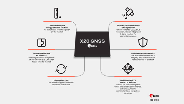
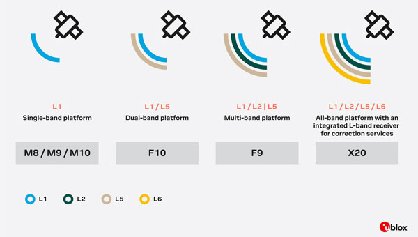
u-blox has introduced the X20, a new high-precision GNSS platform that builds upon its previous F9 platform. The X20 is designed to meet global demands for high-precision GNSS capabilities while accommodating future technologies and standards.
The X20 operates across all GNSS frequency bands (L1/L2/L5/L6) and includes an integrated L-band receiver. The L5 band operates at lower frequencies, which can improve signal robustness, while the L6 band is used for navigation and correction services to enhance positioning accuracy. This comprehensive coverage allows for high-precision positioning even in challenging signal environments.
The platform supports various correction services, including local base stations, real-time kinematics (RTK), network RTK, precise point positioning (PPP) corrections and PPP-RTK.
It is suitable for applications requiring centimeter-level positioning accuracy under challenging environments, such as port logistics, construction machine control, UAVs, autonomous ground robotics (e.g., lawnmowers) and time synchronization for critical infrastructure systems.
The X20 platform incorporates comprehensive security measures such as end-to-end security functions, system authentication via secure boot and firmware updates, message authentication and encryption with a built-in secure root of trust (RoT).
It supports Galileo OSNMA authentication and features advanced jamming and spoofing detection and mitigation. The X20 platform is designed to be software upgradeable, allowing users to adapt to future developments in GNSS technologies and standards.
The United Kingdom’s Ministry of Defence (MOD) is focusing its alternative positioning, navigation and timing (Alt PNT) project on deployable eLoran. This comes after industry days for Alt PNT in March and June 2024.
The announcement came in a Request for Information (RFI) on Sept. 20. It specifies that a contract will be let for the development of a deployable eLoran network. As part of that contract, the MOD also wants to develop:
A modelling capability, which will allow for theoretical analysis of capabilities and informing the concept of employment.
An assured capability within the Loran Data Channel
Information and demonstration of the resulting capability to stakeholders
UK PNT Policy Framework
Last year, the UK government announced a ten-point “policy framework” for advancing the nation’s PNT resilience. One of the ten points is:
“Develop a proposal for a resilient, terrestrial, and sovereign Enhanced Long-Range Navigation (eLORAN) system to provide backup position and navigation.”
Most have seen this as a provision for a fixed domestic system for use by critical infrastructure and applications. The UK already has an on-air single eLoran transmitter that provides a timing signal. An announcement about establishing two or more additional transmitters to provide PNT services for the British Isles and their adjacent waters has been anticipated.
The policy framework also includes:
“Develop a proposal for ‘MOD Time’ creating deeper resilience through a system of last resort and use NTC-provided timing to support MOD.” [NTC stands for National Timing Centre.]
It is not immediately clear how this RFI from the MOD fits these two provisions, if at all, or is entirely separate.
1970s Deployable Loran
Deployable Loran, or Loran-D was first developed for the U.S. Air Force in the 1970’s. An oral history recounts that a system was deployed early in the 70’s by the 6514th Test Squadron at the Utah Test and Training Range (UTTR), a component of Hill Air Force Base. It was built by Megapulse, employed a Hewlett Packard beam clock and 150 ft antennas, and was used for testing unmanned aircraft. There are also indications elsewhere that the Air Force used it for precision bombing.
Industry sources say that this earlier work provides a solid foundation for developing future deployable eLoran systems.
UK MOD Requirements
The RFI is fairly specific about the questions it wants answered. These requirements look nearly ready to be transformed into a Request for Proposal and contract language. They include:
The demonstrator system shall include a minimum of 3 transmitters to enable a suitable receiver to live demonstrate position and time determination from the system.
Across the coverage area, the system shall transmit a signal that allows receivers to achieve position and timing accuracy in line with the needs of defense platforms (which have not yet been specified).
The system shall be able to operate with and without GNSS access.
The system shall be able to operate both with and without access to eLoran signals from eLoran transmitters outside the deployable system’s group.
The system shall be capable of maintaining performance & accuracy for prolonged periods, including without access to eLoran and GNSS signals.
The system shall be able to be contained and transported in an ISO container.
The system shall be able to be assembled, initialized and disassembled by as small a team as possible.
Respondents must submit by the 18th of October to be considered.
“Seen & Heard” is a monthly feature of GPS World magazine, traveling the world to capture interesting and unusual news stories involving the GNSS/PNT industry.
The Northern Plains UAS Test Site (NPUASTS) has assisted the Grand Forks, North Dakota, Fire Department in obtaining a Tactical Beyond Visual Line of Sight waiver from the Federal Aviation Administration, allowing first responders to operate unmanned aircraft systems (UAS) beyond visual line of sight (BVLOS) in extreme emergencies. This capability can be used to assess large fires, conduct aerial searches and locate missing persons. The NPUASTS team trained 11 first responders in UAS operations and flight protocols.
Free Autonomous Shuttle Service Launches in Detroit
Photo: Detroit
A free autonomous shuttle program has launched in Detroit, Michigan. The four electric, wheelchair-accessible “Connect” shuttles will operate every 10 to 15 minutes during peak hours along a 10.8-mile route from Michigan Central to Bedrock’s 200 Walker Street on the East Jefferson Riverfront. Initially, the shuttles will be manually operated to allow for route adjustments and ensure smooth operation of autonomous features. Full autonomous driving is expected later this year.
Maui Recovers One Year After Deadly Wildfires
Photo: Maxar Technologies
New satellite images from Maxar Technologies reveal the extent of damage in Lahaina, Maui, nearly a year after the catastrophic wildfires on Aug. 8, 2023, which resulted in more than 3,900 properties being destroyed and 100 fatalities. Despite the devastation, the satellite image shows signs of recovery, with debris removal progressing and new temporary housing being constructed for displaced residents. The images show cleared lots and returning greenery.
Sea Lions on a Mission
Photo: Nathan Angelakis
Researchers have attached lightweight video cameras to sea lions to explore previously uncharted areas of the ocean off the south coast of Australia. The footage, combined with a machine learning model, produced detailed maps of the ocean floor, revealing the distribution of different habitats and species. This method allows scientists to access deep and remote habitats that are unreachable by traditional hydrographic surveys. The study, published in Frontiers in Marine Science, highlights the potential of using animal-borne cameras for marine exploration and conservation efforts.
Rx Network has launched TruePoint | REACH, an advanced, hardware-agnostic, cloud-based correction service designed to deliver centimeter-level location accuracy worldwide for various professional applications.
TruePoint | REACH offers precise centimeter-level positioning to enhance GNSS receivers’ performance in applications such as precision agriculture, machine control, mining, marine operations, UAV, GIS and more. The service is compatible with leading commercial off-the-shelf receivers using the RTCM 3.3 SSR and the 3GPP LPP SSR format. The company said key hardware partnerships are in the planning stages and will be announced soon.
TruePoint | REACH eliminates the need for users to set up their own base stations. Users can achieve centimeter-level accuracy by connecting receivers to the cloud while leveraging Rx Networks’ comprehensive global coverage.
Its correction engine is built to provide centimeter-level accuracy worldwide and can achieve sub-3cm precision in under 10 minutes. This makes it suitable for applications that require moderate initialization times for high-precision services.
A test version of TruePoint | REACH is available for those interested in assessing its capabilities. Users can sign up for a complimentary 30-day trial license through the Rx Networks website.
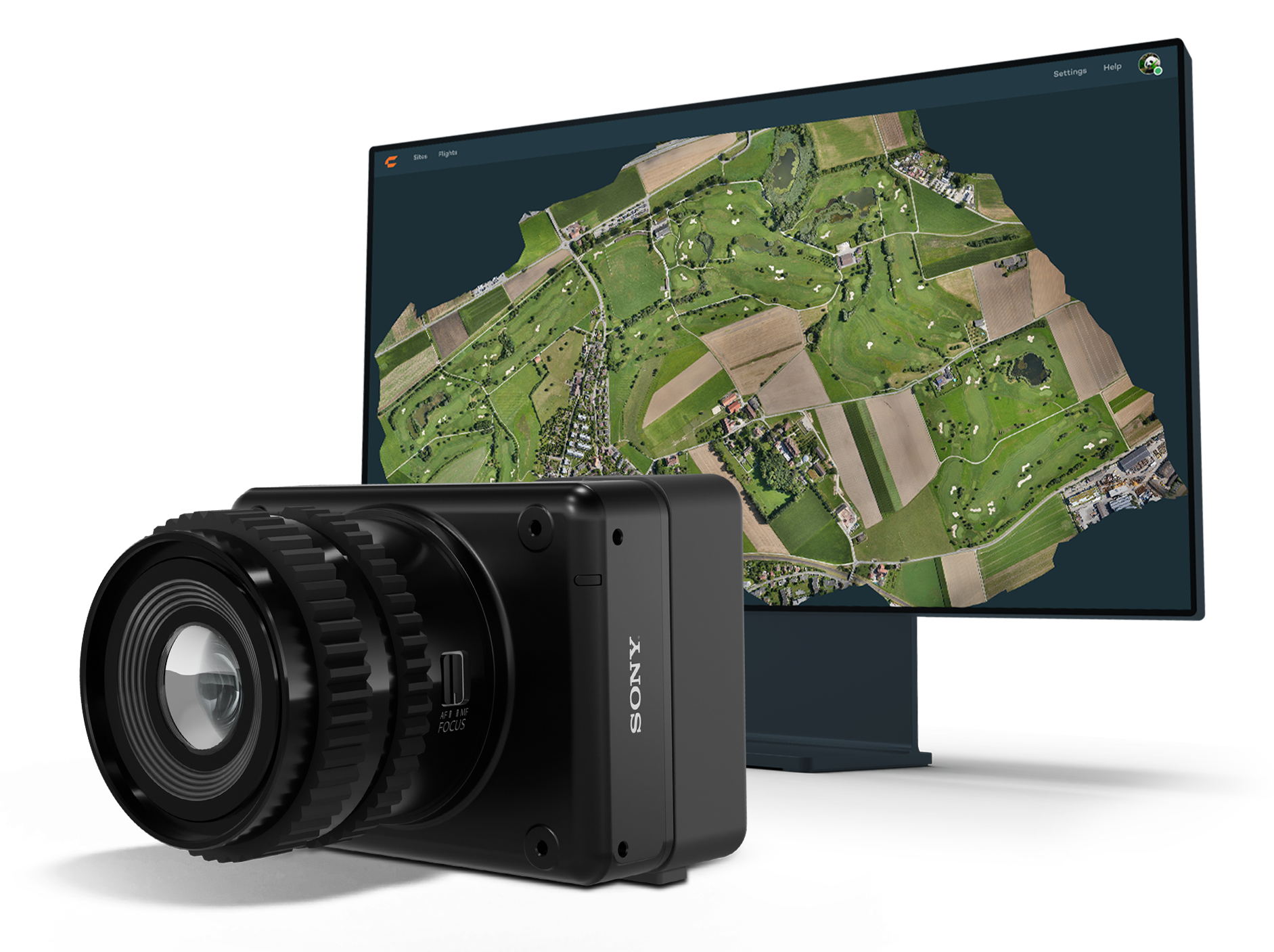
Wingtra has launched the MAP61 mapping sensor, designed to assist professionals in generating larger mapping outputs more efficiently. This ultra-high-resolution sensor offers detailed 3D data in a single pass, providing valuable analytics for vertical assets.
The MAP61 can cover up to 460 hectares (1,140 acres) in a single flight, reducing fieldwork time and enhancing productivity. According to Julian Surber, product manager at Wingtra, the MAP61 can decrease fieldwork time from one hour to approximately 35 minutes while doubling processing speed. This efficiency is beneficial for projects requiring both 2D and 3D data.
MAP61 features oblique sensor configuration, which can facilitate detailed mapping of long structures such as highways without interrupting traffic flow. This design reduces the need for cross-hatch flights, cutting field time in half for vertical resolution and accuracy, which is critical in industries such as construction.
The MAP61 is versatile and suitable for various applications including land management, urban planning, highway mapping and progress monitoring in open-pit mines. Its ability to operate efficiently in challenging environments — such as urban areas or open pit mines —makes it a valuable tool for professionals who need timely data.
The system can integrate seamlessly within an intuitive mapping workflow. Wingtra combines vertical take-off and landing (VTOL) capabilities with its software platform, WingtraCLOUD. This integration allows users to plan, capture and process data without switching between different software applications.
u-blox and Topcon Positioning Systems have formed a strategic partnership to develop a high-precision GNSS positioning service for the mass market.
The partnership was formed in response to the increasing demand for GNSS precise positioning across various applications. According to a recent EUSPA report, services enabled by GNSS devices are projected to generate approximately 80% of total GNSS revenues by 2033.
The comprehensive GNSS correction services will serve a wide range of applications requiring precise positioning, including automotive, industrial, robotics, construction, precision agriculture and mobility sectors. These services will integrate with u-blox’s current and future hardware products, as well as existing services such as PointPerfect.
The increasing prevalence of GNSS spoofing in commercial aviation poses significant safety concerns and highlights the need for robust alternative positioning, navigation and timing (A-PNT) sources. This form of electronic warfare, which uses fake signals to confuse aircraft navigation and safety systems, has become a growing issue for civilian flights worldwide.
Pilots told The Wall Street Journal that spoofing incidents have risen in recent months. According to analyses from SkAI Data Services and the Zurich University of Applied Sciences, the number of affected flights per day increased from a few dozen in February to more than 1,100 in August 2024.
The issue of spoofing has expanded beyond active conflict zones near Ukraine and the Middle East, and now affects hundreds of civilian pilots daily on a global scale. The modern cockpit’s heavy reliance on GPS technology means that falsified data can have far-reaching consequences, breaching multiple aircraft systems and causing disruptions that may last anywhere from a few minutes to an entire flight.
According to anonymized reports shared with government agencies and industry groups, pilots have experienced many alarming incidents, including sudden clock resets, false terrain warnings and unexpected flight path deviations. This surge in GNSS spoofing attacks highlights the vulnerability of critical navigation systems and raises significant concerns about aviation safety in an increasingly complex environment.
All jammed up The Wall Street Journal reported that in August 2024, a United Airlines flight from New Delhi to the New York area encountered a GPS spoofing incident that affected its navigation systems for the duration of the flight.
Initially, the flight seemed to adhere to the standard GPS route across Asia, mirroring the path taken by previous flights heading to Newark Liberty International Airport. The spoofing attack, originating in the Black Sea region south of Ukraine, caused the aircraft’s GPS coordinates to deviate progressively from its actual position throughout the remainder of the flight.
Even after the plane had left the affected area, its reported GPS location continued to show erratic behavior, occasionally making sudden jumps. This suggested that the navigation equipment was struggling to recalibrate accurately. While alternative navigation systems ensured the flight’s safe completion of its intended route, the compromised GPS data indicated that it had terminated in the Atlantic Ocean. In reality, the aircraft landed safely at its scheduled destination in Newark.
Keeping operations safe Aviation safety officials said spoofing has disrupted some flights but has not posed major safety risks. Pilots are trained to use A-PNT systems as backups. However, managing false GNSS signals and alerts risks dividing the operator’s attention if a more severe problem arises.
“If we lose an airplane because of workload issues because of these problems we’re encountering, compounded with an emergency, that is going to be a horrendous event,” said Ken Alexander, the Federal Aviation Administration’s chief scientist for satellite navigation, during a pilot union forum in Washington, D.C.
Airlines are collaborating with aircraft manufacturers, parts suppliers, and aviation safety authorities to devise immediate solutions and long-term strategies. For example, the International Air Transport Association (IATA) and the European Union Aviation Safety Agency (EASA) are openly discussing these challenges and holding workshops to share best practices. Safety bulletins have also been issued for operations where spoofing and jamming are known to have occurred.
Industry insiders told The Wall Street Journal that the development of new equipment standards to enhance civilian aircraft resilience against spoofing attacks is not expected to be finalized until 2025.
Navigating issues across sectors According to anonymized reports collected by OpsGroup, an aviation safety organization that includes pilots, dispatchers and other airline staff, various attacks have caused navigation issues across multiple sectors.
GNSS spoofing has disrupted operations in Europe but has not endangered flights, said Florian Guillermet, executive director of the European Union Aviation Safety Agency. Pilots had to divert to airports they did not intend to land at, and earlier this year, an airline temporarily halted operations at an Estonian airport that was not equipped with ground-based navigation as a backup for GNSS.
Boeing said manufacturers, carriers and regulators globally are contributing GPS expertise for solutions to ensure safety. Boeing and Airbus are working with airlines to help develop procedures to assist pilots, the companies said.
United and American said their pilots are equipped with several ways to navigate with precision, even with GPS interference. American said it has not experienced disruptions or significant safety concerns from GPS interference.
Insights from industry experts
During the 64th Civil GPS Service Interface Committee Meeting — hosted at ION GNSS+ 2024 from Sept. 16-17 — The presentation “Complementing GNSS for Resilient Performance Based Navigation” by Okuary Osechas Ph.D., and Gary A. McGraw, Ph.D., addressed the critical role of complementary positioning, navigation and timing (CPNT) technologies in aviation, particularly in light of increasing threats to GNSS.
The presentation highlights the impact of radio frequency interference (RFI) on aviation, including jamming and spoofing. These pose significant risks to aviation safety by reducing operational margins. The prevalence of these threats is increasing, necessitating alternative navigation solutions.
Performance-based navigation (PBN) is essential for modern aviation, enhancing efficiency and flexibility. However, it relies heavily on GNSS, making it vulnerable to disruptions, again highlighting the need for CPNT services.
Integrating CPNT sources ensures resilient navigation capabilities. This includes leveraging legacy navigation aids and modernized terrestrial systems. Various complementary technologies such as eDME, eLORAN, LDACS-NAV and LEO SATNAV are being assessed for their operational effectiveness, compatibility and potential to support aviation needs.
The researchers recommend the following to address these challenges:
Near-term solutions: Implementing eDME for backward compatibility. Medium-term strategies: Utilizing eLORAN for wide-area time distribution. Long-term goals: Developing LDACS-NAV to enhance spectrum efficiency and standardization. Collaborative efforts: The presentation calls for international cooperation in research and development to advance standards and infrastructure investments in complementary PNT technologies.
Emlid has released updates to its Emlid Flow mobile and cloud app for land surveying. The app now includes a full range of tools for earthworks, topographic and as-built surveys and features such as Surfaces support.
When used with Emlid’s survey-grade Reach GNSS receivers, the upgraded Emlid Flow app aims to improve efficiency for land surveying and construction workflows. Key features added to Emlid Flow include advanced linework capabilities, inverse and traverse tools, polygon support and an auto-collection mode. The recently released Surfaces support allows surveyors to incorporate digital terrain models (DTM) into projects and calculate cut and fill values during stakeout operations.
In developing these updates, Emlid seeks to create an uncluttered, intuitive interface for surveyors while maintaining all necessary controls and functionality. The app offers streamlined navigation and instant cloud syncing, enabling surveying professionals to complete tasks efficiently on their preferred device, whether a rugged Android smartphone or iPad. Projects prepared in the cloud are instantly accessible in the mobile app for field use, streamlining the entire survey process.
CHC Navigation (CHCNAV) has unveiled the i83 Pro, an inertial measurement unit (IMU)-real-time kinematic (RTK) GNSS receiver. This receiver combines GNSS capabilities with extensive compatibility options to address the diverse needs of surveying, construction and mapping professionals.
The i83 Pro incorporates CHCNAV’s third-generation GNSS antenna and the latest iStar algorithm, designed to boost GNSS signal tracking efficiency by 30%, according to the company. With 336 channels supporting GPS, GLONASS, BeiDou, Galileo and QZSS constellations, it can achieve centimeter-level precision rapidly, even in challenging environments.
The receiver offers comprehensive connectivity options, including built-in Wi-Fi, Bluetooth, NFC, 4G modem and UHF modem. These technologies support various GNSS surveying modes, such as RTK Networks NTRIP and UHF base-rover configurations. The i83 Pro is compatible with VRS, FKP and MAC for Network RTK for precise positioning across diverse operational settings.
Engineered for challenging environments, the i83 Pro features an IP68-rated enclosure for dust and water protection, a compact and lightweight design for enhanced portability, a high-resolution color display for clear status information and a 20-hour battery life for continuous operation in rover mode.
The i83 Pro offers optional Trimble RTX and OmniSTAR support, providing RTK-level accuracy without relying on a base station or VRS network. Additionally, it can be equipped with the optional Trimble MAXPro Positioning Engine for extended performance.
CHCNAV will showcase this receiver at INTERGEO 2024 in Hall 3, Booth B3.052.