Category: Space & Earth

  • ArkEdge Space selected by JAXA to develop lunar navigation satellite system

    ArkEdge Space selected by JAXA to develop lunar navigation satellite system

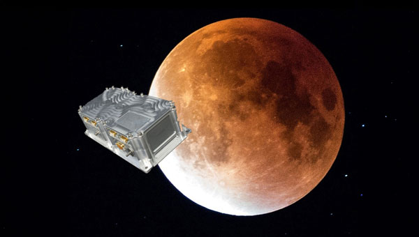
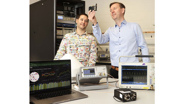
    ArkEdge Space, a Japanese space start-up based in Tokyo, has been selected by the Japan Aerospace Exploration Agency (JAXA) under its Space Strategy Fund to lead the development of advanced lunar navigation technology.

    Under the agreement, ArkEdge Space will plan and design the mass production and operation of micro-satellite constellations to lead the development of a next-generation Lunar Navigation Satellite System (LNSS), a vital component to the International “LunaNet” initiative driven by National Aeronautics and Space Administration (NASA), European Space Agency (ESA) and JAXA. LunaNet seeks to establish essential infrastructure to support sustainable lunar exploration and foster the growth of the lunar economy.

    This program, supported by up to 5 billion yen ($32.5 million) over four years, tasks ArkEdge Space with developing a 100 kg class micro-satellite, developing crucial technology including the:

    1.  Lunar navigation payload
    2.  Demonstration satellite platform, along with a system operations plan
    3. Establishment of an approach to mission evaluation

    These efforts will help reduce development costs and timeframes while advancing core LNSS technologies and enabling the development of future lunar navigation system demonstration satellites, according to ArkEdge Space.

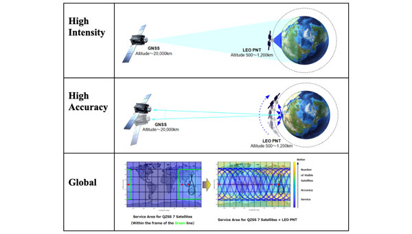
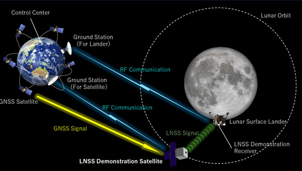
    ArkEdge Space’s work on LNSS leverages its expertise in satellite technology and builds on its ongoing collaboration with JAXA. A key innovation of the project involves the use of faint GNSS signals, originally designed for Earth, to determine satellite position and time in lunar orbit—approximately 380,000 km from Earth. Additionally, LNSS complements advancements in low-Earth Orbit positioning navigation and timing (LEO-PNT) systems, designed to provide high-precision, robust navigation services globally, enhancing existing GNSS infrastructure.

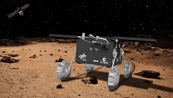
    As lunar exploration accelerates, high-precision infrastructure has become indispensable for activities such as rover navigation, base construction, and in-situ resource utilization. LNSS supports lunar operations and serves as a stepping stone for future exploration of Mars and deep space.

  • NaviMoon project validates GNSS technology for future Moon missions

    NaviMoon project validates GNSS technology for future Moon missions

    SpacePNT and European Engineering and Consultancy (EECL) have completed the final presentation of the European Space Agency (ESA)-funded Earth Moon GNSS Spaceborne Receiver for In-Orbit Demonstration project. This project aimed to develop and qualify the NaviMoon GNSS spaceborne receiver for lunar applications.

    Currently, geostationary orbit (GEO) and geostationary transfer orbit (GTO) missions utilize GNSS signals for in-orbit positioning, navigation and timing (PNT). NASA’s Magnetospheric Multiscale (MMS) mission has shown that GPS signal tracking is possible up to 150,000 km from Earth’s surface, which is half the distance to the Moon. ESA has assessed the feasibility of extending GNSS use for lunar missions through studies under its General Studies Program (GSP). These studies indicate that lunar navigation using GNSS might be feasible if specific high-sensitivity techniques are implemented in GNSS spaceborne receivers.

    NaviMoon is an advanced version of SpacePNT’s spaceborne GNSS receiver NaviLEO. It supports dual constellation (GPS and Galileo) and dual frequency (E1/L1 and E5a/L5) operation. The receiver is based on commercial off-the-shelf (COTS) components with radiation mitigation measures. It features fast digital signal processing in hardware and handles acquisition, tracking control and navigation in software. NaviMoon also includes a dedicated microcontroller for interface management and can be reprogrammed in flight.

    EECL contributed to the project by providing the GNSS reflectometry front end for remote sensing. The company developed the lunar low-noise amplifier (LNA), which is crucial for detecting ultra-weak signals at lunar distances.

    The NaviMoon project involved comprehensive testing, including mechanical tests, thermal vacuum tests, electromagnetic compatibility testing and a full GNSS test campaign. The presentation shared that it is a robust platform with high radiation tolerance and environmental performance. It aims to deliver less than 100 m accuracy at Moon distance while reducing dependence on costly Earth infrastructure for orbit determination.

    This project was funded under ESA’s NAVISP program, which is dedicated to European industrial technology innovation in the PNT sector. It also received support from ESA’s GNSS Science Advisory Committee (GSAC).

  • Silicon Sensing Systems to supply gyroscopes for Mars Moon rover

    Silicon Sensing Systems to supply gyroscopes for Mars Moon rover

    Silicon Sensing Systems has been contracted by the German Aerospace Centre (DLR) to supply two miniature Pinpoint (CRM200) gyroscopes for the Martian Moons eXploration (MMX) mission. This mission will travel to Mars to survey the two moons that orbit the planet.

    The gyroscopes will be installed on the rover vehicle set to explore Phobos — the larger of Mars’ two moons — to collect crucial surface samples. The Pinpoint gyroscopes are designed to detect any unintended movement of the rover on unfamiliar terrain. Depending on the initial assessment of the drivetrain, which includes the gyroscopes, an optional safety module may be activated in the software. This module will automatically prevent instability during the rover’s driving sessions.

    Pinpoint completed TID testing at 17kRad Radiation and Proton tests (up to 68 MeV/proton), demonstrating the gyro’s suitability for space requirements.  

    The size of a small fingernail, at approximately 5mm by 6mm, PinPoint is the smallest gyro in Silicon Sensing’s MEMS product range. This low-drift, single-axis angular rate sensor can be used in various applications.  When integrated, these sensors can precisely measure angular rate across multiple axes — any combination of pitch, yaw and roll —while consuming little power.

    The MMX mission is conducted by the Japanese Space Agency (JAXA) to explore Mars’ two moons, with contributions from NASA, the European Space Agency (ESA), CNES and the German Aerospace Center (DLR). CNES and DLR are jointly developing a 25-kg rover for the mission. The spacecraft is expected to arrive in Martian space approximately one year after departing from Earth and will then enter orbit around Mars.

    It will then move into a quasi-satellite orbit (QSO) around the Martian moon Phobos to collect scientific data, drop the rover and gather a sample of the moon’s surface. After observation and sample collection, the spacecraft will return to Earth carrying the material gathered from Phobos. The current schedule has a launch date in 2026, followed by a Martian orbit insertion in 2027 and a return to Earth in 2031. 

  • Xona Space Systems, QASCOM advance resilient PNT

    Xona Space Systems, QASCOM advance resilient PNT

    Xona Space Systems has partnered with QASCOM to integrate Xona PULSAR into QASCOM’s GNSS software-defined radio (SDR), the QN400-P. The integration is designed to strengthen positioning, navigation and timing (PNT) resiliency in the face of persistent threats.

    The partnership seeks to deliver security, jamming and spoofing resistance and next-gen accuracy for industries such as UAV navigation and defense.


    The QN400-P receiver offers multi-frequency, multi-constellation GNSS capabilities, including GPS and Galileo. Additionally, it includes measures for the mitigation of jamming and spoofing and is compatible with low-Earth orbit (LEO) PNT services, such as Xona’s PULSAR.

    The demand for more robust, secure and accurate navigation is increasing across various industries, including agriculture, construction and autonomous systems. The integration of Xona and QASCOM technologies aims to deliver solutions for these sectors, as well as for other relevant applications and use cases.

  • Space Force’s new GPS satellites running months behind schedule

    Space Force’s new GPS satellites running months behind schedule

    The Pentagon’s first batch of new and more capable GPS satellites, part of the GPS IIIF program, is facing significant delays. The first batch is eight to eleven months behind schedule, which the U.S. Space Force attributed to manufacturing difficulties encountered by contractor Lockheed Martin, particularly with complex components necessary for the satellites’ operation. Originally expected to be available for launch in April 2026, the first satellite’s delivery has now been pushed to November 2026.

    The GPS IIIF program is a $9.2 billion initiative aimed at deploying up to 22 advanced satellites. The first ten satellites in this series are designed to enhance the GPS system with improved accuracy and jamming-resistant signals. These satellites will serve both critical defense applications, such as guiding smart bombs, and civilian uses, such as turn-by-turn navigation.

    The new F-model satellites promise increased navigation accuracy, a signal compatible with similar European satellites, greater resistance to cyberattacks and jamming and civilian search-and-rescue capabilities to detect and locate emergency beacons.

    “For the average driver using GPS navigation,” the new satellites will provide “enhanced route planning and navigation, reducing travel time and improving fuel efficiency” and a “consistent GPS service even in urban canyons and areas with tall buildings,” according to the Space Systems Command.

    According to the US Space Force, The primary obstacle appears to be the production of the Mission Data Unit, a crucial new component for improved navigation. Bloomberg reported that the subcontractor, L3Harris Technologies, manufactures this unit and is experiencing technical issues.

    Despite these setbacks, Lockheed Martin is reportedly on track to meet the contracted delivery dates, even if they miss the Space Force’s preferred “available for launch” schedule.

    Lockheed Martin’s fixed-price contract includes incentives for meeting schedules and keeping costs below U.S. targets. However, the Space Systems Command has indicated that some criteria have not been met, resulting in reduced profit for Lockheed Martin. The exact amount of lost payments has not been disclosed.

    The Space System Command notes that these delays occur against global inflation and supply chain challenges. While these factors have affected industries worldwide, the Space System Command emphasizes that Lockheed Martin, as the prime contractor, is responsible for managing all aspects of the GPS IIIF satellite development and production.

    The GPS IIIF program remains a critical component of the U.S. Space Force’s efforts to modernize the GPS constellation, ensuring its continued reliability and effectiveness for both military and civilian applications in the face of evolving global challenges.

  • Astranis to develop resilient GPS satellites for USSF

    Astranis to develop resilient GPS satellites for USSF

    Astranis has been selected as one of four prime contractors for the U.S. Space Force (USSF) Space Systems Command’s (SSC) new Resilient GPS (R-GPS) program. This initiative aims to augment the existing GPS constellation with small, low-cost satellites to enhance resilience for both military and civil users. The program’s initial phase, Lite Evolving Augmented Proliferation (LEAP), aims to launch up to eight satellites by 2028.

    As part of this effort, Astranis has been awarded an $8 million contract for concept development. The company plans to leverage its expertise in manufacturing and operating low-cost, high-orbit satellites. Specifically, Astranis will utilize its MicroGEO satellite design and Octane Software-Defined Radio hardware to advance the R-GPS spacecraft design.

    The R-GPS program is characterized by a rapid development timeline. It utilizes the “Quick Start” authority, which allows for contract awards in under six months. Ultimately, the USSF envisions a proliferated fleet of over 20 small GPS satellites to enhance navigation and timing capabilities.

    These satellites will incorporate the latest GPS signals, including M-code, to offer optimal performance even in contested environments. In addition to Astranis, other contractors involved in the initial phase include Axient, L3Harris and Sierra Space.

  • Ireland unveils Europe’s first verified GNSS data stream service

    Ireland unveils Europe’s first verified GNSS data stream service

    The National Standards Authority of Ireland’s National Metrology Laboratory (NSAI NML) has launched Europe’s first verified GPS/GNSS Data Stream (VGDS) service, designed to enhance the National Timing Grid of Ireland. This initiative, developed in collaboration with Timing Solutions, seeks to provide users with secure and reliable GNSS data.

    The VGDS service provides verified GNSS data via the Internet through Radio Technical Commission for Maritime Services (RTCM) packets. This allows users to verify their own GNSS data streams to mitigate risks such as jamming and spoofing. The service is crucial for various sectors, including government organizations, public institutions, communications, energy, transportation, financial services and cloud data centers, as it provides accurate time and location data.

    David Fleming, NSAI Technical Manager for Time and Frequency, emphasized the significance of this service, stating, “As Ireland’s digital economy continues to grow and more services and public safety aspects are dependent on GNSS/GPS data, the importance of verifiable GNSS/GPS data in Ireland is paramount.” The VGDS service aims to improve the resiliency of Critical Infrastructure sectors by providing safe GNSS/GPS data and signals.

  • Topcon expands Topnet Live coverage across Western US and Hawaii

    Topcon expands Topnet Live coverage across Western US and Hawaii

    Topcon Positioning Systems has significantly expanded its Topnet Live reference station service, adding 180 full-wave geodetic reference stations across California, Hawaii, Oregon, Nevada, Utah and Washington. This expansion is designed to enhance network corrections, providing centimeter-level accuracy for various industries such as engineering, surveying, construction, and agriculture. The improved service can also benefit specialized applications, including automated mowing, line marking and UAV operations for mapping and delivery in sectors such as the turf industry.

    According to Topcon, one key benefit for users is simplified access to globally supported Networked Transport of RTCM via Internet Protocol (NTRIP) network corrections. NTRIP streams GNSS correction data over the Internet, enabling real-time kinematic (RTK) positioning. This technology allows users to achieve high levels of accuracy in their positioning tasks. In addition to NTRIP corrections, the expanded services now include enhanced Differential Global Positioning System (DGPS) coverage, which seeks to improve mapping accuracy.

    According to Topcon, Receiver Independent Exchange (RINEX) static files are now more readily available. This enhancement offers more robust static and static kinematic post-processing options. These improvements provide users with more precise positioning data and greater flexibility across a range of applications, from surveying to precision agriculture.

  • JAXA selects ArkEdge to study LEO PNT system

    JAXA selects ArkEdge to study LEO PNT system

    The Japan Aerospace Exploration Agency (JAXA) has awarded Japanese startup ArkEdge Space a contract to study the feasibility of establishing a constellation of positioning, navigation and timing (PNT) satellites in low-Earth orbit. The project aims to provide high-precision PNT signals across the globe.

    Government agencies worldwide are exploring ways to complement and back up GNSS, which is susceptible to natural and deliberate interference. In addition, self-driving cars and autonomous drones require extremely precise location data.

    Under the new JAXA contract, ArkEdge Space will provide a conceptual design for a LEO-PNT satellite and its orbit. ArkEdge will also explore satellite and constellation tradeoffs and consider different signal formats and frequency bands.

    With a new LEO-PNT constellation, JAXA seeks to expand the coverage area of service currently provided by Japan’s geostationary Quasi-Zenith Satellite System (QZSS) satellites.

    Under a separate JAXA contract, ArkEdge is developing positioning and communications services for cislunar space.

  • GMV to upgrade Galileo’s European GNSS Service Centre

    GMV to upgrade Galileo’s European GNSS Service Centre

    The European Union Agency for the Space Programme (EUSPA) has awarded GMV a six-year framework contract to upgrade the European GNSS Service Centre (E-GSC) infrastructure. The contract is valued at €35 million ($39 million).

    The E-GSC is critical to the European Union satellite navigation program’s infrastructure. Its primary mission is to provide a unified interface for users of the Galileo and EGNOS systems, offer supporting services, and contribute to delivering new Galileo services. The E-GSC’s various functions include distributing data from the European Union navigation satellite services to the user community and supporting the growth of the global Galileo applications market.

    Originally designed to be part of the European GNSS infrastructure and to provide a unified interface between the Galileo system and its users, the E-GSC has expanded its role over the years to become a key component in delivering services enabled by the European Union Space Programme.

    The new framework contract aims to advance the E-GSC’s capabilities, enabling it to take on increased responsibilities. This includes creating new services for users, enhancing their experience, integrating service delivery aspects of Galileo and EGNOS, and supporting the development of additional services.

    GMV is leading a consortium that features Indra as the main industrial partner, along with prominent companies such as Spaceopal, ESSP, Alten, the Universitat Politècnica de Catalunya (UPC) and the Universidad Autónoma de Barcelona (UAB).

    Under the supervision of EUSPA as Contracting Authority, GMV will oversee project management and IT infrastructure development through all stages, including definition, implementation, validation and integration into the Galileo ground segment. GMV will also develop the software components necessary for delivering new data and signal authentication services for Galileo satellites.

  • RX Networks enhances global centimeter-level location accuracy

    RX Networks enhances global centimeter-level location accuracy


    Photo: Rx Networks
    Photo: Rx Networks

    Rx Network has launched TruePoint | REACH, an advanced, hardware-agnostic, cloud-based correction service designed to deliver centimeter-level location accuracy worldwide for various professional applications.

    TruePoint | REACH offers precise centimeter-level positioning to enhance GNSS receivers’ performance in applications such as precision agriculture, machine control, mining, marine operations, UAV, GIS and more. The service is compatible with leading commercial off-the-shelf receivers using the RTCM 3.3 SSR and the 3GPP LPP SSR format. The company said key hardware partnerships are in the planning stages and will be announced soon.

    TruePoint | REACH eliminates the need for users to set up their own base stations. Users can achieve centimeter-level accuracy by connecting receivers to the cloud while leveraging Rx Networks’ comprehensive global coverage.

    Its correction engine is built to provide centimeter-level accuracy worldwide and can achieve sub-3cm precision in under 10 minutes. This makes it suitable for applications that require moderate initialization times for high-precision services.

    A test version of TruePoint | REACH is available for those interested in assessing its capabilities. Users can sign up for a complimentary 30-day trial license through the Rx Networks website.

  • Galileo constellation expands with two new satellites

    Galileo constellation expands with two new satellites

    Photo: SpaceX
    Photo: SpaceX

    SpaceX has launched the latest pair of Galileo satellites from the Kennedy Space Center in Florida. The SpaceX Falcon 9 rocket carried satellites 31 and 32 (FM26 and FM32) to their designated orbits.

    This launch, number 13 in the Galileo program, marks a crucial milestone in the constellation’s development. The addition of these satellites completes the designed constellation, with the required operational satellites plus one spare per orbital plane. The new pair will undergo testing at their final altitude of 23,222 km before becoming operational.

    European Space Agency (ESA) Director of Navigation Javier Benedicto highlighted the importance of this launch, stating that the remaining six Galileo First Generation satellites are scheduled for deployment in 2025 and 2026.

    These additional satellites are designed to enhance the system’s performance and reliability further, ensuring uninterrupted delivery of highly precise navigation services.

    At ION GNSS+ 2024, Eric Châtre, head of EU GNSS exploitation and evolution at the European Commission, and Miguel Manteiga, Galileo project manager at ESA, participated in a panel titled “Status of GPS, Galileo, BDS, QZSS, KPS and NavIC.” They shared how 2024 has been a particularly eventful year for the Galileo program. In April, satellites 29 and 30 were launched and entered service in September. The new Public Regulated Service (PRS) signals began broadcasting, offering encrypted navigation for authorized governmental users. A significant upgrade of Galileo’s ground segment was completed without impacting users.

    The Galileo system continues to evolve, with the development of Second Generation (G2) satellites underway. These satellites will feature fully digital navigation payloads, electric propulsion and inter-satellite link capacity.