Category: Space & Earth

  • LuGRE receiver captures GNSS signals in lunar orbit

    LuGRE receiver captures GNSS signals in lunar orbit

    The LuGRE receiver acquired and tracked GPS and Galileo satellite signals in lunar orbit on Feb. 19, operating at 63 Earth radii (approximately 401,814 km from Earth). Developed by Qascom for the Italian Space Agency in collaboration with NASA and supported by Politecnico di Torino, the receiver is integrated into Firefly Aerospace’s Blue Ghost 1 lander as part of NASA’s Commercial Lunar Payload Services program.

    During the lander’s lunar transit, LuGRE tracked signals in the L1/E1 and L5/E5 frequency bands. The farthest signal detected came from the Galileo constellation at 67.79 Earth radii (approximately 432,384 km from the receiver). The experiment demonstrated GNSS functionality near the Moon, where the lander orbited approximately 1.66 km/s1.

    Despite the challenges of distance and velocity, the receiver achieved position accuracy within 1.5 km and velocity accuracy within 2 m/s. It successfully acquired signals from four GPS satellites (L1 and L5 frequencies) and one Galileo satellite (E1-E5 bands) during a one-hour observation window. Post-landing, LuGRE will attempt to receive GNSS signals on the lunar surface for 14 days.

  • ESA to develop optical PNT technology

    ESA to develop optical PNT technology

    The European Space Agency (ESA) has signed a contract with a consortium of European companies to conduct a definition study (Phase A/B1) and associated critical technology predevelopment to drive the development of optical positioning, navigation and timing (PNT) technology.

    This initiative marks the initial phase toward a potential in-orbit demonstrator for optical time synchronization and ranging, which is scheduled for proposal at the ESA Council at the Ministerial Level in November. According to ESA, the primary objective is to validate inter-satellite optical links for future implementation in operational satellite navigation systems.

    Optical technology presents promising advancements in navigation accuracy and robustness. While optical links, which use laser beams for data transmission, are already established in satellite communications, their application in navigation requires further technological development and in-orbit validation.

    The consortium, led by German OHB System, comprises 33 companies from various ESA member states. Following the initial study, the next phase would involve developing and testing the technology in orbit to validate novel system concepts and explore new architectures. The results will assess the readiness of optical technology and inform decision-makers about its potential incorporation into future operational systems.

    Laser-based technology offers the potential for enhanced system resilience and robustness, potentially reducing dependence on space atomic clocks and ground segments. Optical links also provide natural immunity to jamming and spoofing attempts.

    The high data transfer rates of inter-satellite optical links could enable new, more robust architectures, supporting a multi-layer system approach to navigation. This aligns with the vision of ESA’s low-Earth orbit (LEO)-PNT program.

    Additionally, optical systems can significantly improve the performance of current navigation systems. Experts anticipate achieving millimeter-level spatial accuracy and picosecond-level timing, which could ultimately lead to enhanced services benefiting billions of users worldwide.

  • Xairos advances US defense with quantum timing technology

    Xairos advances US defense with quantum timing technology

    SpaceWERX, the innovation arm of the U.S. Space Force, has selected Xairos Systems Inc. for a $1.9 million Direct-to-Phase II contract to develop a fusion positioning, navigation and timing (PNT) system. This project aims to integrate quantum and optical synchronization of clock ensembles to address critical challenges faced by the Department of the Air Force (DAF).

    Xairos Systems is collaborating with Luminous Cyber Corporation and Eritek on this initiative. The team has recently completed a Preliminary Design Review. The Air Force Research Laboratory (AFRL) shared that the collaboration is part of a broader effort by the AFRL and SpaceWERX to streamline the Small Business Innovation Research and Small Business Technology Transfer processes.

    AFRL and SpaceWERX seek to streamline the Small Business Innovation Research (SBIR) and Small Business Technology Transfer (STTR) process through faster proposal-to-award timelines, changing the pool of potential applicants by expanding opportunities to small businesses and eliminating bureaucratic overhead by continually implementing process improvement changes in contract execution, according to AFRL.

    In 2018, the DAF launched the Open Topic SBIR/STTR program to broaden its funding for innovations. As part of this initiative, Xairos is developing innovative technologies that enhance the national defense of the United States.

  • Advanced Navigation to develop INS for Gilmour Space rocket launches

    Advanced Navigation to develop INS for Gilmour Space rocket launches

    Advanced Navigation has secured grant funding from the Australian Space Agency through the Moon to Mars Initiative Grant. This funding will expedite the development of a space-grade high-shock inertial navigation system (INS) designed to endure extreme conditions during rocket launches.

    The INS will support Gilmour Space Technologies, an Australian launch services company, in the development and launch of Eris Rockets and Elara Satellite platforms to low-Earth orbits (LEO). This collaboration aims to enhance Australia’s sovereign aerospace capabilities and contribute to the growing space industry.

    The development of this advanced INS presents significant engineering challenges due to the harsh conditions experienced during rocket launches. From lift-off to payload deployment, every phase of a rocket’s journey requires precise engineering and seamless coordination. All electronic and fiber-optic components must be capable of withstanding intense shock, vibration, shifting gravity, payload impact and extreme temperature fluctuations.

    The onboard INS consists of a plethora of high-end sensors, including accelerometers and gyroscopes, sensitive enough to detect the smallest change in noise and vibration. To ensure accurate and reliable performance, these delicate components must be shielded from the extreme forces experienced during launch. One solution is the integration of a high-shock enclosure — a protective barrier encircling the INS housing. This enclosure acts as a cushion between the system and the surrounding structure, absorbing and redistributing intense g-forces from engine ignitions and launch vibrations. By dampening these shocks, the enclosure prevents disruptive forces from reaching the sensors, preserving their precision in the harshest conditions.

  • Iridium considers small satellites for advanced PNT capabilities

    Iridium considers small satellites for advanced PNT capabilities

    Iridium Communications is exploring the potential use of small satellites to demonstrate advanced positioning, navigation and timing (PNT) capabilities.

    Iridium CEO Matt Desch discussed this initiative during the Smallsat Symposium in Silicon Valley, where he suggested the company might venture into the smallsat business, even if only for experimental purposes.

    Desch said small satellites could also support the development of a very-high frequency (VHF) radio system aimed at enhancing pilot communications with Aireon, a provider of aircraft surveillance services using hosted payloads on Iridium’s satellites.

    Iridium operates a constellation of 66 Iridium Next spacecraft in low-Earth orbit (LEO) for L-band connectivity services, along with additional spare satellites. Following an engineering assessment in 2024, the company expects this constellation to remain operational until at least 2035.

    The Iridium Next satellites, weighing approximately 860 kg, are significantly larger than typical small satellites used for LEO communications, which generally range from a few dozen to a few hundred kilograms. While smaller satellites offer advantages in terms of faster and more cost-effective deployment for specific missions, Iridium’s larger satellites are designed for extended operational life, supporting its global, cross-linked network.

  • EUSPA launches GNSS and secure SATCOM user technology report

    EUSPA launches GNSS and secure SATCOM user technology report

    The European Union Agency for Space Programme (EUSPA) has released its first GNSS and secure satellite communications (SATCOM) user technology report, offering an overview of recent developments in GNSS and SATCOM. This publication combines and expands upon previous GNSS user technology and secure SATCOM market and user technology reports, offering a comprehensive look at current trends and advancements in user technology.

    The report examines the satellite industry’s ongoing transformation, influenced by evolving security concerns, increased digitalization efforts, rapid progress in artificial intelligence (AI) and the emergence of the New Space sector. By addressing these topics, the report aims to provide stakeholders with up-to-date information on the state of satellite-based technologies.

    Focusing on both GNSS and Secure SATCOM, the publication explores recent innovations in user technology, such as terminals and receivers. It also investigates potential synergies between these two fields. This approach allows readers to gain insights into how these technologies are developing in parallel and potentially converging in certain applications.

    Developments and trends in GNSS technology

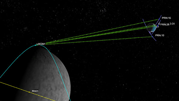
    The report opens with a summary of the recent developments and future trends in GNSS technology that are relevant to end users. As new GNSS frequencies and signals become available for civilian applications, receiver manufacturers have been upgrading their products to accommodate satellites in medium-Earth orbit (MEO). The international coordination among GNSS supports this advancement, Radio Navigation Satellite Service, and Satellite-Based Augmentation System providers, resulting in the adoption of open access signals with compatible frequency plans, common multiple access schemes and modulation schemes.

    The report states that a service-oriented approach to GNSS is emerging, building upon existing infrastructure to offer users enhanced performance and security. The European GNSS program has made significant strides in this area, backed by the recent implementation of the Galileo High Accuracy Service (HAS) and Open Service Navigation Message Authentication (OSNMA) feature. The Report gives insight into emerging technologies and upcoming innovations, focusing on key trends in receiver electronics design and signal processing aimed at improving performance or reducing power consumption. Multi-frequency capabilities, PNT processing strategies and advances in antenna design are identified as key drivers shaping the future of GNSS receiver technology, according to EUSPA.

    Among other topics selected, the spoofing and jamming threats are becoming a priority to be addressed both at the system and user level. Solutions such as Galileo OSNMA authentication and more resilient receivers with multiple antennas and sensor hybridization are being explored and are starting to be implemented.

    Developing secure SATCOM systems

    The secure SATCOM section of the Report outlines trends in the secure SATCOM domain by emphasizing enhanced performance and system management optimization. It specifically highlights how digitalization processes, cloud environments and AI techniques are enhancing performance and system management optimization in the secure SATCOM domain. It also notes the ongoing efforts to standardize the integration of non-terrestrial networks into the 5G ecosystem.

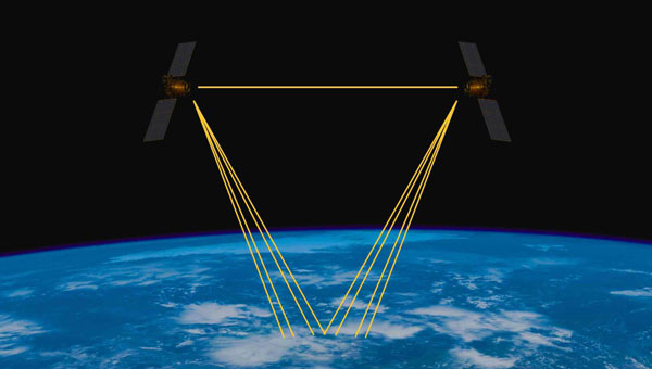
    According to EUSPA, the deployment of large Non-Geostationary Orbit (NGSO) constellations aims to improve performance, particularly in reducing transmission latency. These systems rely on advanced user terminals capable of tracking and switching between multiple fast-moving satellites across the sky.

    The report also emphasizes security in SATCOM transmissions, recognizing that satellite communications encounter similar threats from malicious signals as terrestrial communications. Consequently, both governmental and commercial SATCOM systems are being developed with a rising focus on enhancing the confidentiality, integrity, and availability of both governmental and commercial SATCOM systems links.

    It also describes a shift in SATCOM systems from legacy hardware-centric designs to modern software-oriented solutions. This digital transition allows user terminals to utilize multiple constellations and frequencies, which significantly improves the availability of communication links. This can help mitigate disruptions caused by natural factors or intentional interference.

    Exploring potential and existing synergies

    The report concludes with an examination of existing synergies between GNSS, secure SATCOM, and Earth observation (EO). Notable examples include the transmission of EO data through SATCOM systems, utilizing GNSS for operating NGSO SATCOM terminals, the complementary use of GNSS and secure SATCOM in transport and emergency management, remote sensors used by Copernicus — a European EO program — that rely on both GNSS and SATCOM and high-accuracy GNSS positioning in remote areas enabled by SATCOM.

  • GMV to develop Galileo High Accuracy Service data generator

    GMV to develop Galileo High Accuracy Service data generator

    The European Union Agency for the Space Programme (EUSPA) has selected GMV to develop a new version of the High Accuracy Data Generator (HADG) as part of Phase 2 of the Galileo High Accuracy Service (HAS) development. 

    This service offers free real-time precise positioning corrections to all Galileo system users. The first version of the HADG, also developed by GMV, is currently operational and provides users with the Initial Service (Phase 1) of the HAS. 

    The new contract spans up to 45 months and has a budget of up to €12 million. It covers the design, development, deployment, and support to commissioning, along with optional maintenance of an enhanced version of the HADG. This updated version will integrate the functionalities necessary for providing the services outlined in Phase 2 (Full Service) of the HAS deployment. 

    The new version of the HAS data generator seeks to improve the performance level of Service Level 1 (SL1) by deploying a new version of GMV’s magicPPP algorithms for precise corrections calculation and expanding the ground station network. This aims to provide global coverage and enhance the accuracy and availability of the SL1 service. Additionally, it will implement a new Service Level 2 (SL2), a regional service available only in Europe that will transmit atmospheric corrections to reduce the convergence time required to achieve maximum accuracy at the user level. 

    Another key feature of the new HADG version is the implementation of a new functionality for the authentication of HAS corrections transmitted through the Galileo constellation, thereby increasing user security and confidence in the service. 

    Since 2020, GMV has led the development of the Galileo HAS data generator following the award of the first contract with EUSPA. Since its operational launch in January 2023, the Galileo HAS service has provided accuracy for advanced applications in sectors such as navigation, agriculture, geodesy, and autonomous driving. In the new contract, GMV maintains its role as the main contractor and leader of an industrial consortium that includes atmospheric modelling experts from the Polytechnic University of Catalonia (UPC) and cybersecurity specialists from Sidertia.

  • EnSilica receives funding from UK Space Agency for satellite broadband terminal chips

    EnSilica receives funding from UK Space Agency for satellite broadband terminal chips

    Logo: EnSilica
    Logo: EnSilica

    EnSilica, a chip maker of mixed-signal application-specific integrated circuits (ASICs), has been awarded funding from the UK Space Agency under its Connectivity in Low-Earth Orbit (C-LEO) program. Following a competitive selection process, EnSilica has been awarded £10.38 million ($12.8 million) throughout the next three years for a development project pioneered by EnSilica.

    “This is a great opportunity to accelerate our chipset development, enabling us to extend our portfolio of chips for the satellite broadband market with a focus on providing a complete solution for user terminals while reducing cost and power,“ said Paul Morris, EnSilica vice president of RF and communications business unit.

    EnSilica provided its application with supporting letters of interest from potential lead customers to develop a family of semiconductor chips to support future generations of mass market satellite broadband user terminals. According to the company, the terminals will be capable of connecting with various satellite constellations and will leverage advanced semiconductor technology. In addition, the project will provide a resilient source of chips, which will be independent and not tied to specific satellite service operators.

    The UK Space Agency’s C-LEO program was launched in 2024 and is designed to ensure that the UK space sector remains competitive in the rapidly evolving global market for low-earth orbit constellations. With a total funding pool of up to £160 million ($198 million) available over the next four years, the C-LEO program supports the development of smarter satellites, enhanced hardware, artificial intelligence-driven data delivery and improved inter-satellite connections.

    This new project builds on EnSilica’s long history of collaboration with the UK Space Agency and the European Space Agency, alongside other key satellite communications partnerships and the company’s own investment in the technology.

  • Indian navigation satellite stranded in transfer orbit after valve malfunction

    Indian navigation satellite stranded in transfer orbit after valve malfunction

    The Indian Space Research Organisation (ISRO) has encountered a significant setback with its recently launched NVS-02 navigation satellite. Launched on Jan. 28, 2025, the satellite is currently stranded in a transfer orbit due to a critical failure in its onboard propulsion system, ISRO stated in a report. The issue occurred when the valves admitting the oxidizer to fire the thrusters for orbit raising failed to open, which prevented the satellite from reaching its intended orbital position.

    The NVS-02 satellite, part of India’s Navigation with Indian Constellation (NavIC) program, was launched using a Geosynchronous Satellite Launch Vehicle (GSLV) Mark II rocket from the Satish Dhawan Space Centre. The launch placed the satellite into a geostationary transfer orbit with a perigee of approximately 165 km and an apogee of approximately 37,582 km.

    ISRO noted in its statement that other systems on the spacecraft were working well, including a successful deployment of its solar panels.

    “The satellite systems are healthy and the satellite is currently in elliptical orbit. Alternate mission strategies for utilizing the satellite for navigation in an elliptical orbit are being worked out,” ISRO stated.

    The space agency is now exploring alternative mission strategies to utilize the satellite for navigation in its current elliptical orbit. However, the low perigee of NVS-02 poses a significant risk, as it exposes the spacecraft to high atmospheric drag, potentially leading to an early reentry if the orbit cannot be raised.

    NVS-02 is based on ISRO’s I-2K satellite bus, which has been used for other Indian communications and navigation satellites operating in geostationary orbit. The spacecraft had a launch mass of 2,250 kg.

    The spacecraft was intended to operate at 111.75 degrees east in GEO, replacing the IRNSS-1E spacecraft there. It is the second of five satellites planned for India’s Navigation with Indian Constellation, or NavIC, program to provide positioning, navigation and timing services in India and the surrounding region. The first, NVS-01, launched in 2023 and operates in GEO.

  • CRPAs for PNT removed from ITAR list

    CRPAs for PNT removed from ITAR list

    The Directorate of Defense Trade Controls (DDTC) has changed the regulatory status of Controlled Reception Pattern Antennas (CRPAs) for position, navigation and timing (PNT). Starting September 2025, CRPAs will no longer be subject to the International Traffic in Arms Regulations (ITAR). Instead, they will be reclassified under the less restrictive Export Administration Regulations (EAR) list, which is under the jurisdiction of the Department of Commerce.

    The rule, in part, removes items from the U.S. Munitions List (USML) “that no longer warrant inclusion.” According to the rule, “certain anti-jam antennas no longer provide a critical military advantage, with increasing commercial utilization applicable to civil GPS resiliency.”  By removing CRPAs for PNT, “the Department intends to facilitate civil global navigation system resiliency.”

    The recent regulatory change is expected to significantly impact several industries, including airlines, autonomous vehicles, UAVs and critical infrastructure applications, which can benefit from the increased availability of CRPAs. Additionally, this change may open the U.S. market for CRPA manufacturing, potentially resulting in swift technological advancements and lower costs.

    The importance of CRPAs lies in their ability to protect GNSS receivers from interference and jamming. GNSS signals are inherently weak and susceptible to both deliberate and unintentional interference. CRPAs work by adjusting their reception pattern to create nulls in the direction of interfering signals while maintaining reception from desired satellite signals. This adaptive beam steering capability allows CRPAs to effectively eliminate signals from particular directions while preserving signals from others, making them a powerful tool in ensuring the reliability of GNSS-dependent systems.

    Click here to read the full announcement.  

  • GPS III SV-07 becomes operational

    GPS III SV-07 becomes operational

    The U.S. Space Force transferred Satellite Control Authority of the GPS III Space Vehicle 07 (SV-07) to the 2nd Navigation Warfare Squadron, Mission Delta 31, at Schriever Space Force Base, Colorado. The satellite became operational and available to global users on Jan. 22, 2025 — expanding the GPS constellation to 31 active vehicles. The transfer is the first instance in which the Satellite Control Authority moved from the acquisition program to the operations squadron within a single Delta, reflecting the new mission delta structure. 

    The space vehicle was launched on Dec. 16, 2024, from Cape Canaveral Space Force Station, Florida, aboard a SpaceX Falcon 9 rocket as part of a Rapid Response Trailblazer mission. The operation involved retrieving an existing GPS III satellite from storage, expediting integration and launch vehicle preparation, and swiftly processing the satellite for launch. 

    The entire process, from initiation to launch, was completed in approximately three months, significantly shorter than the typical six-month pre-launch processing timeline. This accelerated timeline was achieved through collaboration between multiple Space Force organizations and partner agencies.

    The GPS III SV-07 satellite is equipped with M-code, designed to improve anti-jamming and anti-spoofing capabilities, enhancing secure access to military GPS signals. This launch contributes to the ongoing modernization of the GPS constellation following the launch of GPS III SV06 in 2023. Mission Delta 31, activated on Oct. 15, 2024, is responsible for providing, operating, and sustaining high-integrity positioning, navigation and timing (PNT) capabilities. It comprises three squadrons and one detachment, including the 2nd Navigation Warfare Squadron, which operates the GPS satellite constellation.

  • FrontierSI releases LEO PNT state of the market report

    FrontierSI releases LEO PNT state of the market report

    FrontierSI has released its Low-Earth Orbit (LEO) Positioning, Navigation, and Timing (PNT) 2024 State of the Market Report. This report offers a comprehensive overview of the emerging LEO PNT market, showcasing its transformative potential in satellite navigation, the challenges it addresses and the key players shaping its evolution.

    PNT services are integral to industries worldwide, from logistics and telecommunications to critical infrastructure. The rise of LEO satellites is set to revolutionize this space, overcoming limitations of traditional GNSS, such as vulnerability to interference and limited urban coverage, according to FrontierSI.

    Key insights from the report, which is the first in a series of annual reports, include:

    • Industry impacts: How LEO PNT addresses GNSS vulnerabilities, offering more robust and accurate navigation solutions.
    • Government and regulatory challenges: The rise of commercial PNT players necessitates collaboration to address interoperability, spectrum management and governance issues.
    • Business innovation opportunities: Critical sectors such as logistics and autonomous systems stand to benefit from assured and precise PNT services.
    • Investment potential: The nascent stage of the LEO PNT market presents opportunities for investors to identify game-changing technologies and key players.

    The report is recommended for professionals and organizations deeply engaged in satellite navigation, including:

    • Engineers, designers and project managers in the space and defense industries
    • Autonomous systems manufacturers
    • Policymakers and regulatory bodies responsible for satellite navigation and spectrum management
    • Commercial stakeholders in telecommunications, transport and logistics
    • Academics, researchers and analysts with an interest in satellite navigation technologies
    • Investors analyzing the growth potential of LEO PNT solutions
    • Providers of critical infrastructure reliant on precise timing synchronization

    The LEO PNT State of the Market Report aims to provide stakeholders with the necessary insights to navigate this transformative period for PNT.