Maritime Robotics, a Norwegian provider of autonomous technology, and Teledyne Marine have delivered several unmanned surface vessels (USVs) to Ukraine’s Navy for advanced sensor data collection.
Maritime Robotics’ Otter USV, equipped with the Teledyne RESON SeaBAT T51-R multibeam echosounder, is now being used by Ukraine’s Navy. The USV is designed for critical data collection without endangering human lives, as the sensors are carried by an unmanned vehicle. The data and information collected by the USV aims to strengthen Ukraine’s defense, enhance maritime traffic security and support the safety of civilians in the areas.
Otter USV is part of Maritime Robotics’ portfolio of autonomous technologies capable of supporting military personnel in mapping and securing marine environments. Controlled and navigated remotely, Maritime Robotics’ USVs are designed to identify, locate and safely neutralize potential threats such as explosive devices and sea mines.
The U.S. Army has awarded Lockheed Martin and Northrop Grumman other transaction agreements (OATs) for the first phase of the Launched Effects (LE) program.
Launched Effects “will provide standoff sense and effect capabilities for soldiers while keeping air and ground forces outside the range of adversary weapon systems,” according to the service’s Program Executive Office for Intelligence, Electronic Warfare and Sensors. It also said LE will also support forces entering and exiting mission areas.
Northrop has been awarded for two payloads and Lockheed Martin has been awarded for one, with each award valued at about $100,000, according to the Army. The OTA will total about $37 million over all three phases.
The LE program consists of three phases. During that span, the Army aims to mature payloads from a technology readiness level of 6, a prototype system that has been tested in a relevant environment, to TRL 7, a prototype that has been demonstrated in an operational environment.
Launched effects have been successfully tested by the Army in the past, including at Project Convergence. In January 2023, General Atomics Aeronautical Systems announced its Eaglet launched-effect flew for the first time, dropping off an Army-owned Gray Eagle Extended Range UAV during a demonstration in Utah.
The Air Force was initially opposed to GPS. How did that change?
Between 1978 and at least the mid-1980s, maybe even the late 1980s, the Air Force tried several times to cancel the program. At the time, I was a Capitol Hill staffer for the House Intelligence Committee. In one of those efforts to cancel GPS, Tom Cooper, who was a lead staffer for the House Armed Services Committee, came to me and said, “Can you guys give any reason for keeping GPS?” And I said, “Yes, it greatly improves the accuracy of SIGINT [signals intelligence] locations. It makes a very big difference.”
So, Tom used that, along with other arguments, for why we should keep GPS. The Committee and Congress ultimately decided they would, despite the Air Force’s resistance.
The Air Force’s resistance came from the Strategic Air Command, which in the 1980s believed it would never use satellites. They were concerned about the satellites being shot down. I found this amusing because they were flying around in aircraft at a few thousand feet and were concerned about satellites flying at 11,000 miles. But they were, so they were laggards.
Image: USAF/Staff Sgt. Kyle Johnson
Which service adopted GPS first and why?
The service that by far led the way was the Army. It spent $100 million a year absorbing NRO capabilities. They also spent money on GPS, though not as much. By the time we got to the first Gulf War, in 1991, we had a partial GPS constellation — I think of 18 satellites of the 24 required — and that meant that you didn’t have 100% coverage all day long. So, coverage maps of their areas of interest were generated every day to let people in the field know when they would have service. Most of them didn’t have receivers either. Most of the receivers they did have were Precision Lightweight GPS Receivers (PLGR), knows as “pluggers”, which were the first “handheld” receivers, but they were pretty big.
Once the fight got going, many of the troops wrote home and asked their moms and dads to send them civilian receivers.
Yes! Thousands and thousands of them showed up in theater. Some troops taped them to the windscreens of their helicopters or jet aircraft. They were just jury-rigged into everything because, despite their limitations at the time, they were very, very useful, unlike anything else. So, now everybody realized, “Oh my goodness, this is really a big deal. This is a game changer!”
Then we got more modern receivers, integrated receivers, the whole thing. However, at the end of the Gulf War, the Air Force still had no plan to equip any of its aircraft with GPS. As Assistant Secretary of the Air Force, I was called over to the Armed Services Committee and asked, “What is your plan for integrating GPS receivers into your aircraft fleet?” I said, “There is no plan.” and they were incredulous. They looked at me like “Well, you’re an idiot.”
It wasn’t me, however, and the staff knew my story before I gave it. As a result, Congress mandated it. They put it in that year’s National Defense Authorization Act (NDAA). Within less than 10 years you had Joint Direct Attack Munitions (JDAM) and other GPS-guided weapons. So, that got it moving quickly.
By the end of the 1990s, the Air Force was fully on board and were equipping their aircraft with many weapons that depended on GPS. Meanwhile, GPS had moved to a full constellation of 24 satellites. Full operating capability was declared in 1995. The Navy proceeded similarly, but they were somewhat less affected. So, the Army remained a leader in using space.
The Chief of Staff of the Air Force asked me about Air Force use of GPS. I said, “Chief, the Air Force builds a lot of space stuff, but it doesn’t use it.” Of course, a short time later it was using it extensively. So, this ramp-up was very rapid — just a few years from “I don’t give a darn about these things” to “I can’t live without them.”
Brad Parkinson and his successors as JPO directors designed and built the system but had no role in its adoption, right?
No. They were going turn it over to the production house, if you will, and they did. Once the Air Force got on board with GPS guided weapons, adoption proceeded rapidly.
What about the Navy?
I don’t recall the Navy particularly. I do not at all accuse them of being laggards. I think they did what they needed, whatever that was.
Did later NDAAs expand that mandate to the other services?
I don’t know. I was out of the government by that time, so I lost track. I don’t think it was necessary. What people didn’t understand immediately was that you could do anything with this system. At the end of the day, it is a super accurate timing signal. There are many things you could do with that and people have done them. It quickly became evident that it was so pervasively useful, that anything you could think of involves GPS, from the era of the first Gulf War onward. By 10 years later, many weapons systems in all the services were GPS-guided. I later served on the board of ATK and we were building GPS-guided artillery rounds. I am pretty sure that the ATACMS [Army Tactical Missile System] you hear about today is GPS guided.
So, in a couple of years, all the services wanted to integrate GPS in all their platforms and weapons.
Well, except that the amazing thing was, despite all the things that people had done with GPS in the Gulf War — starting with those helicopters that went in the first night and took out the command and control system, which were guided by Army-provided pluggers taped onto the windscreens by their pilots, and downed pilots using GPS to give their coordinates to the rescue teams — at the end of the war the Air Force still didn’t have a plan to put them on its aircraft! That’s when Congress mandated it. It was amazing.
Despite that, once they got going, particularly once they got going with GPS-guided weapons, everything changed. I don’t know whether the Air Force became leaders, but they were certainly aggressive integrators of the program into the service. There was no more, “We won’t use satellites” and all that.
That was after my time. I left government in early 1993. There were other big fish to fry at the same time. As important as I realized it was, I still didn’t realize how important it was, and I was way ahead of most everybody else, in the Air Force anyway.
The Federal Aviation Administration’s (FAA’s) chief scientist at the time said, “The great thing about GPS is that it is a tool around which you can build myriad capabilities.” He outlined a few for the FAA, many of which they have since done. The same thing began to happen in the services, particularly in the Air Force, in which GPS-guided weapons were pervasive within 10 years.
Part of Brad’s motto for JPO was “The mission of this program office is, number one, to drop five bombs in the same hole.”
Yeah. By the way, one mistake that people make a lot is they think there were GPS-guided weapons during the first Gulf War. That was not the case. There were none by then. There were precision guided munitions that were guided by maps and lasers and a variety of means. But, despite the belief of many authors, there were no GPS-guided weapons at that time.
So, which was the first conflict in which GPS was used?
It was the Iraq War, in 2003. It was a major user of GPS-guided weapons.
Any other thoughts on the 50th anniversary from the military side of things?
It is impossible to overemphasize the importance to military operations and, frankly, to civilian life as well, of being able to easily and accurately navigate or have highly accurate time.
You can do it with a $100 receiver, whereas it used to require a $10,000 receiver and you had to have it re-initialized from a standard. So that’s what everybody does. Now, this has created probably more dependency than is healthy and many nations have backup that we don’t have.
Such as Loran-C. That’s a big subject of debate these days, as you know.
Well, it’s been a subject of debate for 20 years. Everybody agrees, but nobody moves.
The Department of Transportation recently released an action plan on the adoption of complementary PNT systems. So, there’s some movement.
As a one-time government bureaucrat, what you do when people are on your back is launch a study and say, “Well, it will be done in a year or two.” They have done this time, after time, after time.
“I know where we are. I do not need a satellite system to tell me!” In the 1970s and 1980s, this was the number one military and civilian response to what GPS does. The existing military hardware included navigation systems and the defense industry had a vested interest in keeping its business. Civilian interest in GPS was low because of the program’s uncertain funding. The armed services saw no reason to add a new program to their budgets and were opposed to GPS.
The military program approval process was also inconsistent with the rapid changes in digital technology. The first GPS satellite was launched in February 1978, the first PC was released in August 1981, and the first Mac in January 1984. GPS went through a development process to build user equipment, test it to make sure it met military requirements and then build the limited-rate production equipment with a design about six years old.
Early GPS Manipack worn by JPO Army deputy Lt. Col. Paul Weber. This photo graced the cover of the first ever GPS brochure. (Image: GPS World archives)
My favorite joint service story is that our low cost, 19-lb, $55,000, hand-carry man pack flunked its first testing sequence. The Army placed it into an alkaline bath in September 1985, that ate the o-ring and caused it to fail the bio/chem decontamination requirement. The o-ring was an Air Force requirement because at 60,000 ft without venting the device would become a potential bomb. Yet, pressure relief failed to meet the Navy Seals’ requirement for underwater operation. The fixed man pack was now our limited rate production set. Developments in digital technology during the process made it overweight, over cost and unsuitable. To get hand-carry receivers, it became necessary to purchase modern civilian sets at the unexpected outbreak of the First Gulf War in 1990.
JPO ran a competition for 200 civilian receivers that had no military requirements to send them to the operational forces for training. Trimble won the competition and when the war came the following year with only 12 GPS satellites operational, JPO asked Trimble to deliver as many sets as it could produce at the price bid for the competition to augment the deliveries of the limited rate production military set. Talk about an operational education! The Army tank drivers who did not want GPS because “The war comes to us, so we do not need GPS” instantly demanded GPS receivers when they began to get lost by more than 10 miles on the featureless desert. The deployed troops began asking their parents for GPS receivers for personal use. The war integrated GPS into all military operations.
Realizing the value of GPS inter-service integration of forces, the military believed the civilian signal should only have degraded accuracy. But in May 2000, President Clinton decided the civilians also should have good accuracy and ordered that the degradation of the civilian signal (called Selective Availability) should cease. Today everybody is aware of what GPS provides. You never hear anyone say, “I know where I am, I do not need satellites to tell me.”
Electronic warfare in the Middle East and Ukraine is affecting air travel far beyond the battlefields, unnerving pilots and revealing unintended consequences of a tactic that experts believe will become more widespread, reportedThe New York Times.
Planes are losing satellite signals, flights have been diverted and pilots have received false location reports or inaccurate warnings that they were flying close to terrain, according to European Union safety regulators and an internal airline memo viewed by The New York Times. The Federal Aviation Administration (FAA) has also warned pilots about GPS jamming in the Middle East.
Following Russia’s invasion of Ukraine in early 2022, radio frequency interference only continues to increase across the Middle East as of autumn 2023. These interferences can involve jamming GNSS signals to obstruct or block them using noise, or mimicking signals to trick GNSS receivers into picking up counterfeit satellite signals, known as spoofing.
Aircraft systems have been unable to detect GPS spoofing and ultimately correct for it. According to Opsgroup, an organization that monitors changes and risks in the aviation industry, one Embraer jet bound for Dubai nearly veered into Iranian airspace in September before the pilots figured out the plane was chasing a false signal.
“We only realized there was an issue because the autopilot started turning to the left and right, so it was obvious that something was wrong,” crew members reported to Opsgroup.
Issues arise
With the rise of electronic warfare, the strain on aviation could be a sign of more serious economic and security issues.
The U.S. government calls GNSS signals “an invisible utility.” Smartphones, cars, stock exchanges, data centers and countless industries rely on them for time, navigation or both. Similar systems exist around the world, such as Galileo in Europe, Glonass in Russia, QZSS in Japan, NavIC in India and BeiDou in China. One study from Britain said a five-day disruption of satellite signals could cost the country $6.3 billion.
Minor interference with GPS signals is fairly common. GPS jamming devices, while illegal to use, are inexpensive and easy to obtain from vendors on the internet. Governments, too, have been more willing to overtly interfere with signals as a tactic in electronic warfare.
It is not always possible to distinguish jamming from spoofing, or to determine who is behind the interference. Israel said in mid-October it had restricted GPS in the region and had warned pilots not to rely on satellite navigation systems for landing.
Russian interference is well-documented. A 2019 report by the Washington-based analytical nonprofit group C4ADS showed extensive spoofing from a Russian-controlled air base in Syria. Reports also indicated that, when Russian President, Vladimir Putin, traveled to remote locations or Russian-occupied Crimea, he was flanked by mobile GPS-spoofing technology.
Jamming is common in conflict zones. Spoofing, until recently, was considered rare.
The interference has been felt up to 190 miles away from battlefields and “appears to go well beyond simple military mission effectiveness,” according to Eurocontrol, Europe’s primary air-traffic-control manager. The worst-affected regions include the aerial space above the Black Sea area from Turkey to Azerbaijan; the Mediterranean Sea extending from Cyprus to Libya; the Baltic Sea near Poland and Latvia; and the Arctic near Finland and Norway.
Airbus said it recorded nearly 50,000 interference events on its aircraft last year, more than four times as many as the year before. This came on top of an over twentyfold jump in radio-interference events from 2017 to 2018, as recorded by a voluntary incident reporting system run by Eurocontrol. Eurocontrol said the increased jamming since 2018 was most likely meant to interfere with battlefield UAVs.
In the Middle East, there have been reports of false signals telling pilots their aircraft were directly above the airport in Tel Aviv despite being far away. Opsgroup said it had received around 50 similar reports. In some cases, onboard equipment showed that planes were approaching airports in Baghdad, Cairo or Beirut, Lebanon, when they were not.
Looking ahead
Spoofing is hard to distinguish because the signal appears legitimate. Only Europe’s Galileo incorporates an authentication system that can verify when a signal is from its satellites. Galileo, which currently is the most accurate and precise navigation satellite system, plans to introduce an even stronger level of authentication, according to the European Commission.
But even Galileo’s authentication cannot protect against one of the most dreaded types of spoofing, known as “meaconing.” In a meaconing attack, a spoofer would record satellite signals, and then rebroadcast them with an amplification or a delay. Experts have not publicly confirmed any meaconing attacks in the Middle East.
Opsgroup said the latest events should prompt manufacturers to re-examine the integration of satellite signals in aircraft electronics, known as avionics, without a safeguard that can identify false signals.
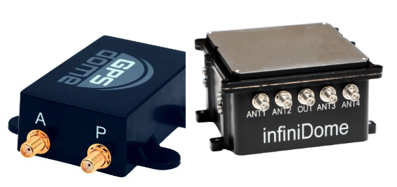
In this environment of intentional GPS jamming and spoofing, Israel has produced a leading anti-jam technology company, InfiniDome, located in Caesarea. According to co-founder Omer Sharar, the company has been working to defend GPS signals for more than seven years and has also seen the rise of devices to jam the GPS L1 frequency that anyone can buy online for $100.
Most readily available jammer electronics only output interference disrupting GPS L1, which is commonly installed for vehicle tracking and UAV guidance. InfiniDome says it has successfully protected trucking, UAV operations and others in Israel and around the world with its Infinidome GPSdome-1 and GPSdome-2 anti-jam products.
It is clear the conflict’s repercussions extend well beyond the battlefield, highlighting the critical need for security assessments or alternative PNT systems to protect civilians. While there is going to be a significant impact on commercial airline travel to and from Israel while hostilities continue, there is hope for a possible long-term solution for the intense jamming that has plagued the region for years.
BAE Systems’ digital GPS anti-jam receiver (DIGAR) has entered the next phase of the Phase 4 Enhancements (P4E) capability program for the Eurofighter Typhoon.
DIGAR is designed to enhance the Typhoon’s ability to withstand GPS signal jamming, spoofing, and radio frequency (RF) interference, ensuring optimal mission execution in challenging RF environments.
The receiver uses advanced antenna electronics, high-performance signal processing and digital beamforming for improved GPS signal reception and jamming immunity, which aim to increase the level of GPS jamming protection. These capabilities are critical for combat aircraft as they maneuver through a contested battlespace.
This upgrade, coupled with BAE Systems’ GEMVII-6 airborne digital GPS receiver, reinforces the Eurofighter Typhoon’s role as a component in air security for the UK and its international allies.
In addition to Typhoon, DIGAR is also installed on the F-16, F-15, and other special-purpose aircraft in the United States such as air interdiction and force protection platforms, intelligence, surveillance or reconnaissance aircraft and UAVs.
Inertial Labs has been awarded an SBIR Phase III contract by the Army Applications Laboratory of Army Futures Command. This award supports Inertial Labs development, design and fabrication of the Cannon Artillery Pointing and Sighting System (CAPSS) for potential use on the U.S. Army’s Paladin and the extended range cannon artillery (ERCA) vehicles.
The CAPSS aims to dramatically reduce weight on the target vehicle platforms by providing a digital replacement for the vehicle’s current panoramic telescope (PANTEL). The PANTEL is used as a sighting system for the gun when the fire control system is inoperable. The CAPSS prototype is being designed to physically replace the PANTEL.
CAPSS is a collection of cameras, inertial measurement units (IMUs), advanced electronics and an intuitive tablet-based user interface. Designed to digitally mirror the PANTEL, the CAPSS system allows soldiers to emulate all PANTEL functions via the tablet, bypassing the need to physically manage the telescope.
More than 400 lbs in equipment weight is eliminated by replacing the current equipment with CAPSS, which improves the vehicle’s operational efficiency. Additionally, the features integrated within CAPSS eliminate the need for warfighters to leave the vehicle cabin for typical aiming and sighting activities connected to the PANTEL setup, such as working with the auto-collimator. All of the functionalities are inherently embedded in the CAPSS, which simplifies operations.
The CAPSS camera technology is also used for semi-automated ranging capabilities. Warfighters can effortlessly zoom in on specific objects, offer estimated data based on the object’s attributes, such as size estimation, and the system will generate the estimated range to that particular object.
Looking ahead, Inertial Labs plans to continue research on optical/inertial-based GPS-denied navigation designed for land vehicles, integrating both camera systems and inertial sensor data.
TRX Systems has announced it is now shipping the Dismounted Assured Positioning, Navigation, and Timing (PNT) System Generation II (DAPS GEN II) solution to the United States Army. The device provides assured PNT to warfighters operating in GPS-denied environments.
In March, the U.S. Army Program Executive Office for Intelligence, Electronic Warfare and Sensors awarded TRX a seven-year, $402 million contract to deliver the DAPS GEN II systems.
TRX DAPS GEN II is a small, handheld device that features efficient power utilization algorithms that enable a continuous stream of assured PNT data for warfighters and their combat systems. To achieve this, the device fuses inputs from a diverse range of PNT sources including M-code GPS, a secure and higher-powered military GPS capability that is resilient against jamming and other threats, complementary sources of position and time data when GPS is degraded, and inertial sensors supporting integrity and positioning, independent of any satellite source.
The TRX DAPS II system is available for purchase by U.S. government entities. Distribution to U.S. allies is restricted to approved cases in the Foreign Military Sales Program.
The United Kingdom’s Minister for Science, Research, Innovation announced in Parliament today a 10 point “policy framework” for advancing positioning, navigation, and timing (PNT).
The announcement addressed improvements to both PNT technology and policy.
Six technology efforts were listed:
“National Timing Centre: develop a proposal for a National Timing Centre (NTC) to provide resilient, terrestrial, sovereign, and high-quality timing for the UK (UTC(NPL)), including sovereign components and optical clocks.” This project has been underway for some time and is being executed by the UK’s National Physical Laboratory. The announcement said another £14 million had been identified and was being allocated to the project.
“MOD Time: develop a proposal for ‘MOD Time’ creating deeper resilience through a system of last resort and use NTC provided timing to support MOD.”
“eLORAN: develop a proposal for a resilient, terrestrial, and sovereign Enhanced Long-Range Navigation (eLORAN) system to provide backup position and navigation.” In May, the UK’s spectrum office, Ofcom, sought interest from industry in obtaining eLoran broadcast licenses. The U.S. Department of Transportation issued a similar request for information this month.
“UK SBAS: develop a proposal for a UK Precise Point Positioning Satellite-Based Augmentation System (SBAS-PPP) to replace the UK’s use of the European Geostationary Navigation Overlay Service (EGNOS), monitor GNSS and enable GNSS-dependent high accuracy position for autonomous and precision uses.” Since Brexit, the UK has not been a part of the EU’s Galileo enterprise. This SBAS decision comes after the UK government researched and rejected the idea of establishing its own GNSS.
“Next Generation PNT: deploy existing R&D funding into a UK Quantum Navigator and investigate possible options for a UK sovereign regional satellite system.” Britain has made development of quantum capabilities, including PNT, a particular national focus.
“Infrastructure Resilience: rollout resilient GNSS receiver chips, develop holdover clocks, and consider options for legislation on CNI sectors to require minimum resilient PNT.” The U.S. Executive Order 13905 points in a similar direction as this idea for legislation, which is a good segway to the announcement’s policy provisions.
Four organizational and policy initiatives included in today’s statement in Parliament:
“National PNT Office: establish a National PNT Office in the Department of Science, Innovation and Technology to improve resilience and drive growth with responsibility for PNT policy, coordination, and delivery.” Last year the Resilient Navigation and Timing Foundation reported a cross-government office had been established by the UK that included representation from the Ministry of Defence. That office was within the Department for Business, Energy & Industrial Strategy (BEIS). Since then, BEIS has been split into two departments, one of which is Science, Innovation, and Technology.
“PNT Crisis Plan: retain and update a cross-government PNT crisis plan to be activated if GNSS-provided PNT is lost and identify and implement short term mitigations.” Similar plans exist in the United States. The absence of an interference detection and monitoring system, though, has helped stymie U.S. government efforts to respond quickly and effectively.
“PNT Skills: explore options for centers for doctoral training in timing and PNT and review PNT skills, education, and training for longterm sovereign PNT capability.” A similar need has been identified by the U.S. President’s National Space-based PNT Advisory Board.
“Growth Policy: develop a PNT growth policy, including R&D programs, standards and testing, to drive innovation for PNT based productivity.” The U.S. PNT R&D Plan is a similar effort.
Also mentioned in the statement to parliament are two new PNT documents published today by the UK Space Agency. The first is a summary of technical concepts developed under the Space Based PNT Programme. The second is an updated report on the economic impact to the UK of a disruption to GNSS.
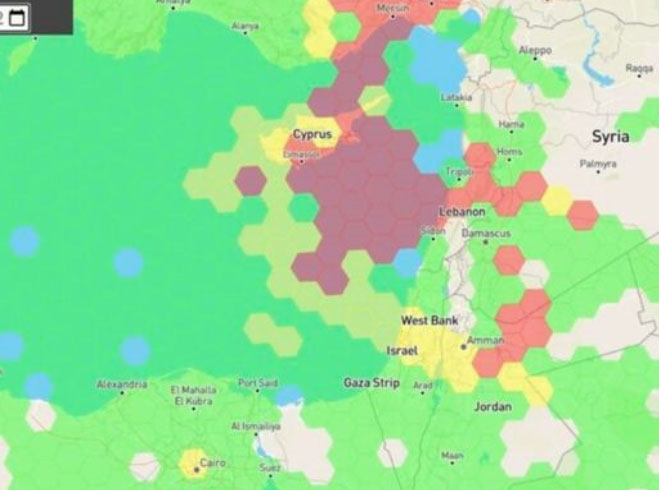
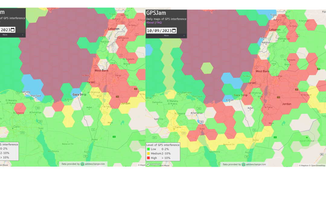
Just as I was beginning to write this article, war broke out between Israel and terrorist forces in Gaza. It would seem that the rockets used by Gaza were aimed rather than carrying on-board guidance, while Israeli airforce bomb/rocket attacks have been carried out with some degree of precision. Nevertheless, jamming in Israel may still be relevant to the ongoing conflict and any on-going commercial aircraft activity. However, it seems from the diagram of jamming below, that the Gaza strip is virtually interference free.
One of the things you can be sure of in the Ukraine-Russia war is that one side or the other is jamming the other’s communications and sat-nav guidance systems. An apparent consequence is that there is likely some “spill-over” to adjacent areas. For Israel, however, it looks like it’s more directed jamming rather than incidental.
Israel GPS jamming. (Image: GPS Jam.org)
In this environment of intentional GPS jamming, it’s not surprising that Israel has produced a leading anti-jam technology company, called InfiniDome, in Caesarea (between Haifa and Tel-Aviv). According to co-founder Omer Sharar, the company has been working to defend GPS signals for more than seven years and has also seen the rise of devices to jam the GPS L1 frequency that anyone can buy online for $100.
Just as Ukraine is throwing explosive cardboard UAVs with little cost at Russian occupying forces, a few carefully placed low-cost jammers could inflict serious damage on a country’s navigation capabilities.
However, a 2019 presentation by Todd Humphreys identified the source of interference and spoofing at that time, a Russian high-power jammer located at a Russian base in Syria.
Humphreys used instrumentation on the International Space Station (ISS) to gather data on the directed interference but concluded that the jamming in Israel could be a consequence of Russia’s efforts to protect its troops in Syria from UAV attacks. The Russian Khmeimim Air Base is on the Mediterranean coast and attacks are thought to come from rebels within Syria.
With the current GPS jamming out of Syria, most commercial aircraft traffic flying into Ben Gurion International Airport is significantly affected as flights cross from over the coast from the Mediterranean. Longer flight tracks deeper southeast into Israel are necessary, probably relying on VOR and DME ground station waypoints before turning back northwest to capture the instrument landing system (ILS) into the airport. This costs time and fuel and causes aircraft to overfly settlements where noise can be a real problem.
Most readily available jammer electronics only output interference disrupting GPS L1, which is most commonly installed for vehicle tracking and UAV guidance. InfiniDome has successfully protected trucking, UAV operations and others in Israel and around the world with its Infinidome GPSdome-1 and GPSdome-2 anti-jam products.
Two antennas 10 cm to 25 cm apart enable GPSDome-1 algorithms to detect and null out a GPS L1 jammer. GPSDome-2 accommodates up to four antennas and can null up to three directional signals on both GPS L1 and L2 or GPS L1 and GLONASS L1.
InfiniDome is currently working with an aerospace company to integrate its anti-jam technology with airborne inertial/GPS and qualify the integrated system for use in civil aviation, with the objective of maintaining max 3% drift when fully jammed. This will introduce certified anti-jam technology into civil aviation use — something that will provide some jamming protection, which airlines desperately need going forward. In addition, other high-end UAV manufacturers are potential customers for this new system.
While the ongoing conflict and the devastating loss of life is forefront as each day of the war passes, these anti-jam solutions may ultimately help solve signal degradation problems. While there is going to be a significant impact on commercial airline travel to and from Israel while hostilities continue, we can maybe see the way to a possible long-term solution for the intense jamming from which the region has suffered for many years.
ANELLO Photonics has added real-time centimeter-accurate positioning and localization capabilities to its line of optical-gyroscope based navigation systems.
Its real-time centimeter accuracy is achieved by using real-time kinematic (RTK) correction data from GEODNET, a community-based decentralized network of over 3,000 GNSS reference stations worldwide.
Under the agreement, ANELLO Photonics users will have access to a free trial of RTK services and competitive options for long-term, high-volume correction data requirements.
By combining the ANELLO silicon photonics optical gyroscope (SiPhOG) with GEODNET’S global RTK correction network, users now have access to a new global cyber-infrastructure for reliable measurements.
The partnership offers users a combination of optical gyroscope technology and a reliable and global RTK correction network that enables centimeter-accuracy for industries operating in challenging RF and GNSS-denied environments. These environments include city centers, construction sites and orchards.
The agreement aims to address the challenging applications by using SiPhOG and its GNSS-denied dead-reckoning algorithms with GEODNET’s distributed global network of RTK stations. This combined technology offers high-level accuracy while reducing the total solution costs.
The companies aim to simplify performance intensive applications such as high-definition mapping and aerial or terrestrial autonomous vehicle deployment.
ANELLO is currently engaged in trials with users in the construction, farming, robotics, trucking, UAVs, autonomous vehicles, and defense space.
Israel has declared war on the Palestinian militant group Hamas after it carried out an unprecedented attack by air, sea and land on October 7, 2023.
The large-scale surprise attack has left more than 1,200 dead in Israel, said Israel Defense Forces spokesperson Lt. Col. Jonathan Conricus in an update on October 11. It has since prompted retaliatory Israeli airstrikes on Gaza that have killed more than 1,055 people.
During the ongoing conflict between Israel and Hamas, the Middle East is witnessing a significant shift in the patterns of GPS interference, with data showing an increase in disruptions compared to just a week prior, according to Defence and Security Middle East.
Reports have surfaced indicating Hamas has actively jammed Israeli communication systems during the initial stages of the conflict. This strategic move highlights the increase of jamming GPS and communication networks in modern warfare scenarios, where precision and coordination are imperative.
Positioning, navigation and timing (PNT) services play a role in a variety of military systems and civil technologies. These services not only guide precision warfare, but also facilitate efficient transportation, communication and various civilian applications.
The Middle East has a history of being a focal point for jamming and spoofing activities, impacting not only security but also regional stability and even commercial flights.
For example, there have been recent reports of recurring interference allegedly caused by Russian systems in Syria, which frequently disrupts air traffic at Tel Aviv’s Ben Gurion airport. Regulatory bodies, such as the Federal Aviation Administration, the European Union Aviation Safety Agency, and Israel’s aviation authority, advised airlines to exercise caution when operating in the airspace of the region. Multiple airlines have now canceled or suspended flights.
With airlines reducing services and regulatory bodies advising caution, the conflict’s repercussions extend well beyond the battlefield, highlighting the critical need for security assessments or alternative PNT systems to protect civilians.