The U.S. Space Force’s Space Systems Command (SSC) has awarded a $1.9 million contract to Slingshot Aerospace to enhance its GPS jamming and spoofing detection capabilities. This contract, Positioning, Navigation and Timing – Secure Electronic Navigation Threat Intelligence and Location (PNT-SENTINEL), aims to improve the company’s existing technology by incorporating advanced artificial intelligence and predictive analytics.
The PNT-SENTINEL program builds upon Slingshot’s previous work under the Data Exploitation and Enhanced Processing (DEEP) contract, awarded in October 2021. The technology developed through DEEP currently assists the U.S. Space Force in detecting GPS jamming and ground-based interference sources related to ongoing conflicts, potential future conflict zones and counterterrorism efforts.
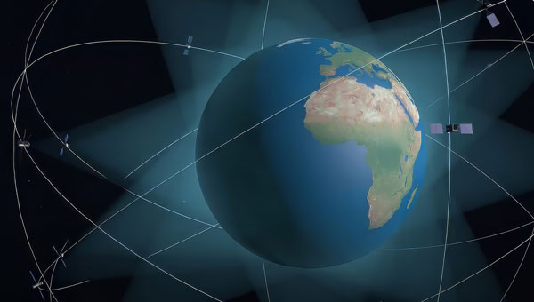
GPS spoofing and jamming pose significant threats to both military operations and civilian infrastructure. Such interference can impact a wide range of operations, including satellite systems, ground and air operations and critical services such as commercial airline operations and vehicle navigation. The global reliance on GNSS has increased the importance of protecting these signals from interference.
Slingshot’s technology utilizes a mesh network of thousands of satellites to create a near-real-time picture of GPS jamming occurrences worldwide. This space-based approach offers a more comprehensive view of global jamming conditions compared to traditional ground-based detection systems.
As part of the contract, Slingshot will integrate its AI model, Agatha, into the PNT-SENTINEL system. This integration aims to enhance the technology’s ability to detect and differentiate between unintentional interference and deliberate jamming or spoofing attempts. The improved system will also implement pattern recognition algorithms to identify active jamming events and predict how situations may evolve.
The contract also includes provisions for expanding the system’s capabilities to monitor interference across multiple GNSS sources, not just GPS. This multi-GNSS processing will allow for a more complete, real-time view of jamming activities by incorporating data from allied nations’ spacecraft.
The PNT-SENTINEL system is designed to be interoperable with existing military systems, enabling near-real-time information dissemination to support rapid decision-making in national security operations. These enhancements aim to provide warfighters with a strategic advantage in GPS-contested environments.
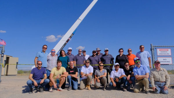
At sunrise on Oct. 1, 2024, SL-15 launched into a perfectly clear blue sky over the desert from Spaceport America, in Las Cruces, New Mexico. The flight — conducted by UP Aerospace with support from NASA’s Flight Opportunities program — carried aloft the payloads and hopes of researchers from three countries — Italy, Germany and the United States — and ten organizations.
Spaceport America, the first commercial spaceport in the world, is an FAA-licensed launch complex. Situated on 18,000 acres adjacent to the U.S. Army White Sands Missile Range in southern New Mexico, it has a rocket-friendly environment of 6,000 square miles of restricted airspace, low population density, a 12,000 ft by 200 ft runway, vertical launch complexes and about 340 days of sunshine and low humidity.
UP Aerospace, a Denver-based company created in 1998, conducted its first suborbital flight from Spaceport America in 2006, which was also the inaugural flight from the spaceport. UP Aerospace maintains a launch complex, a payload processing center and a space propulsion center at the spaceport. Its launch operations and SpaceLoft suborbital launch vehicle were designed and built as a reliable, low-cost Reusable Launch Vehicle (RLV) system.
NASA’s Flight Opportunities program rapidly demonstrates technologies developed by industry, academia, as well as NASA and other government scientists through testing with various commercial flight providers. The program matures capabilities needed for NASA missions and commercial applications while strategically investing in the growth of the U.S. commercial space industry. Available flight platforms include suborbital rockets, rocket-powered landers, aircraft flying parabolic profiles to achieve reduced gravity, high-altitude balloons, and hosted orbital vehicles.
Interoperability test
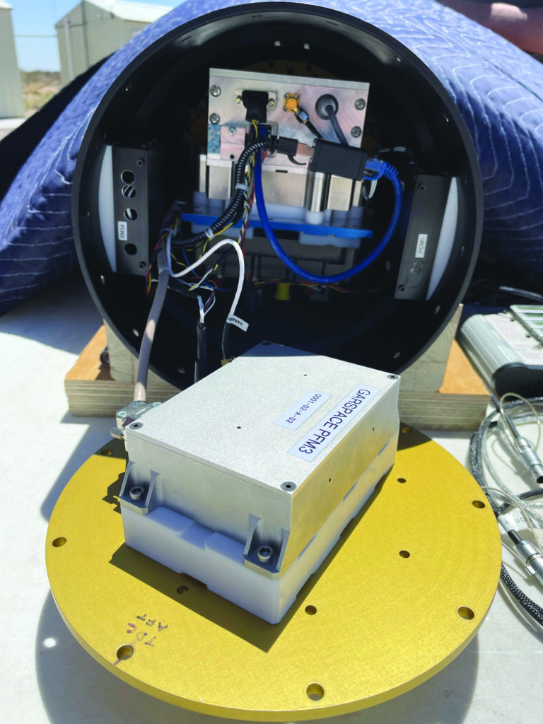
One of the payloads carried to suborbital heights by the SL-15 rocket was a suite of multi-GNSS receivers from NASA’s Space Communications and Navigation (SCaN) program, the European Space Agency (ESA) / European Space Operations Centre (ESOC), the Italian Space Agency (Agenzia Spaziale Italiana or ASI), and their contractors Fraunhofer (a German, publicly owned research and development organization) and Qascom (a private Italian engineering company offering security solutions in satellite navigation and space cybersecurity). A key goal of the flight test was to determine the scope of the interoperability of these receivers. The full results of the test will be presented at the intercessional meeting of the International Committee on GNSS (ICG), a part of the United Nations Committee for the Peaceful Uses of Outer Space (COPUOS) in Vienna in June 2025.
One of the other payloads on the flight was an experiment by the New Mexico Institute of Mining and Technology — aka New Mexico Tech — on spacecraft health monitoring and real-time systems built by the company Immortal Data, which also tested out and collected environmental data on some of its own equipment as it relates to product development. Another payload was an advanced prototype Automatic Dependent Surveillance-Broadcast (ADS-B) transmitter that could potentially be used for independent, low-cost tracking of space launch vehicles.
Lisa Valencia, an electrical engineer for Overlook Systems Technologies, Inc. and NASA’s SCaN Program at NASA Headquarters, was the program manager for the SCaN payload mission. In November 2019, SL-14 tested NASA’s Autonomous Flight Termination Unit as well as Qascom’s GNSS signal recorder. Oscar Pozzobon, co-founder, president, and CEO of Qascom, was able to post-process the data collected by the recorder. SL-15 was originally planned to launch in November 2022; however, it was scrubbed due to interference between the launch vehicle’s S-band transmitter and the L-band GNSS receiver on board. In May 2023, the original SL-15 booster was used for SL-17, a mission carrying student payloads, which experienced an anomaly, ending the flight test three seconds after launch. Therefore, Valencia, her team, and the other teams involved were elated when the October 2024 launch was successful.
Building on the success of the previous SL-14 launch, the SL-15 mission to fly two GPS-Galileo receivers on a sounding rocket is the result of an agreement between NASA, ASI and ESA. The primary objective was to assess GPS-Galileo performance in a highly dynamic environment. The secondary objective was to have the GNSS receivers integrated with the avionics on board the vehicle, with the aim to test the real time use of PVT available during the flight, in contrast to post processing on SL-14. This allowed the evaluation for operational use of multi-constellation / multi-frequencies GNSS for Autonomous Flight Termination Systems (AFTS). AFTS is an independent launch vehicle subsystem designed for range safety operations. From 2014 to 2019, Valencia was the project manager for AFTS in the Engineering Directorate at NASA’s Kennedy Space Center.
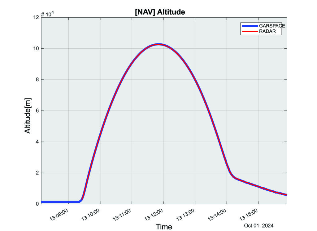
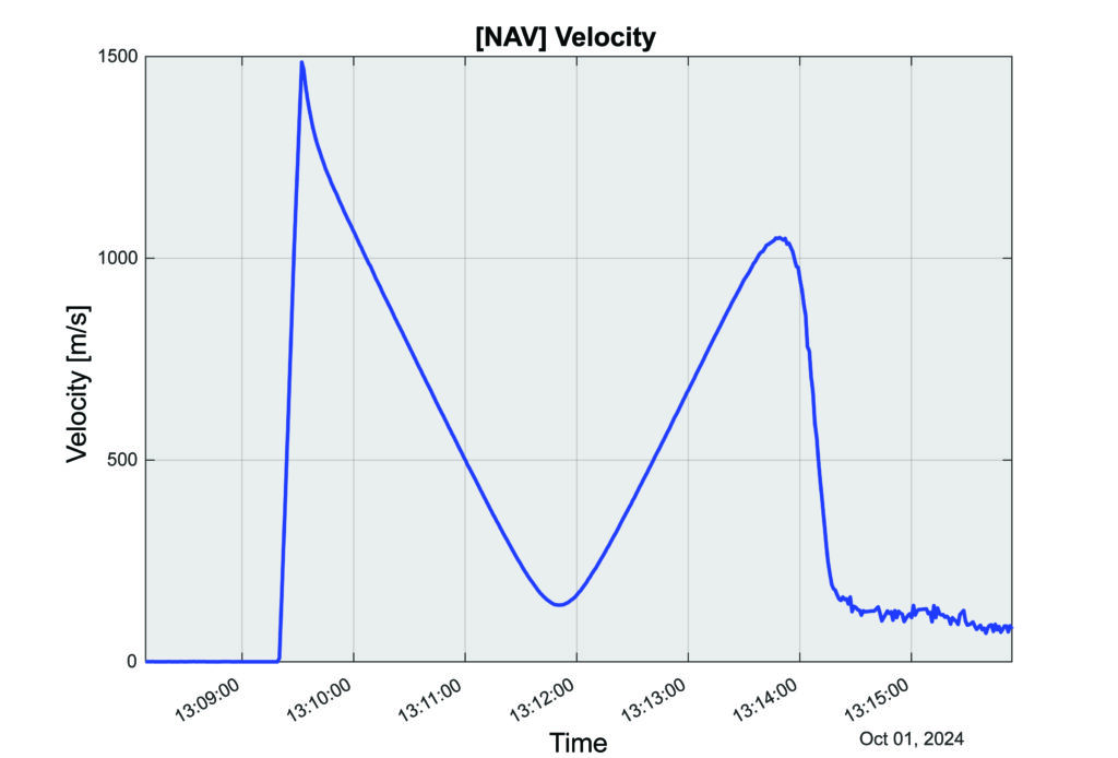
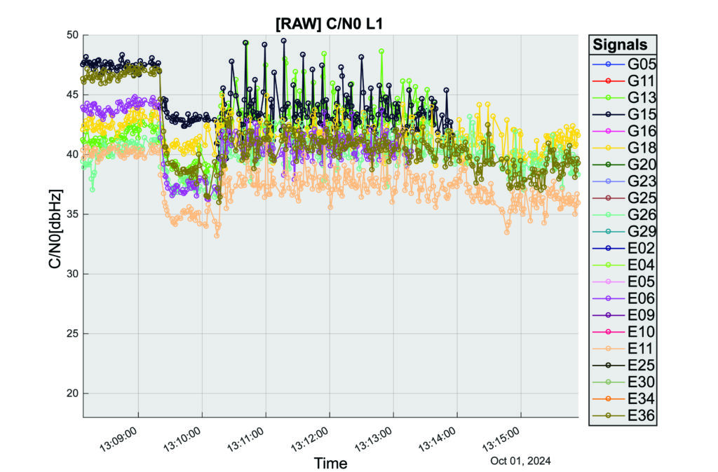
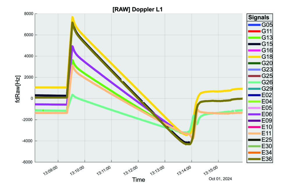
The interoperability experiment on the SL-15 mission included two Autonomous Flight Termination Units (AFTU) and two GPS-Galileo receivers utilizing the L1/E1/L5/E5a signals: a GNSS Dual Frequency / Dual Constellation QN400-SPACE receiver for GPS-GALILEO Receiver for Human Exploration & Operations (GARHEO) program of ASI and Qascom, and a GNSS Receiver with Open Software Interface (GOOSE) receiver from ESA/ESOC and Fraunhofer; as well as a JAVAD GPS L1 receiver. During the flight, a 12-second launch and boost phase was followed by ascent coasting until the rocket reached apogee at an altitude of 115 km, followed by descent, re-entry, and landing, for a total flight duration of 13 minutes. The rocket reached a maximum speed of 1400 m/s, a maximum acceleration of 13.5 G, and a maximum spin rate of 7 Hz.
The NASA sponsor for the GNSS Payload mission is James J. Miller, Executive Director of the National Space-based Positioning, Navigation, and Timing (PNT) Advisory Board with the SCaN Program. The team members are:
NASA: James J. Miller, Lisa Valencia, Hubert Chang, Paul De León, Anh N. Nguyen
ASI:Giancarlo Varacalli, Claudia Facchinetti, Mario Musmeci
During this highly dynamic flight, all GNSS receivers successfully tracked, with high accuracy, based on position, velocity and time (PVT) solutions, meeting the interoperability payload objectives of dual constellation (GPS and Galileo) and dual frequency (L1/E1 and L5/E5a) compatibility.
One plot of the rocket’s altitude changes over time produced from the data collected is striking: a blue line representing the data from the GARHEO and a red one representing data from a monitoring radar on the ground overlap perfectly, resulting in a single purple line on the graph.
During a launch, space vehicles rely on GNSS signals for tracking, monitoring, and safety. Their ability to receive signals from multiple GNSS constellations would offer launch vehicles more precise and reliable real-time PVT information. The SL-15 GNSS experiment demonstrated the benefits of interoperability between Galileo and GPS in highly dynamic environments.
The next step will be a detailed analysis of the data collected during the flight. ESA/ESOC’s next steps will be to process the data from the GOOSE receiver taken on-board and to apply different concepts and algorithms in order to achieve the highest possible accuracy for the SL-15 flight trajectory. Among them will also be a Precise Point Positioning (PPP) GNSS technique that utilizes the GOOSE receiver data in combination with precise orbits and clocks for Galileo and GPS, which will be calculated by ESOC’s Precise Navigation System (EPNS) software. Results are expected in early 2025. ASI/Qascom’s next steps include utilizing the data collected by the SL15 experiment to support the development and validation of the new generation of high dynamics GNSS receivers providing enhanced robustness against GNSS threats. This is the main objective of Qascom’s receiver. At least one launch vehicle is planning to incorporate a multi-GNSS (GPS + Galileo) receiver into their AFTS.
Quotes
“The success of SL-15 is the result of a multi-year collaborative effort with the Italian Space Agency (ASI) and the European Space Agency (ESA) to develop multi-GNSS capabilities to improve resilience for space users. The multi-national SL-15 team worked extremely well together to overcome many challenges, leading to a successful mission. The successful launch of SL-15 was particularly rewarding to our international team in light of the numerous delays we had due to export control restrictions, high winds at the launch site, and key personnel catching COVID-19 during pre-launch checkout. These delays, however, gave us time to resolve payload interference issues identified during one of the launch preparations as well as have our payload reassigned from a rocket with a faulty engine that ended up failing on another mission (SL-17).”
— Lisa Valencia
“The key benefit of this mission was validating our ability to track both GPS & Galileo signals under the highly dynamic conditions of a sounding rocket launch. These included an initial acceleration to 14G (or 14 times the gravitational acceleration on Earth’s surface), a 7 Hz spin rate (seven spins every second), and a maximum speed more than 1400 m/s (3,132 mph).”
— A.J. Ora, Ph.D.
“The integration of GPS+Galileo for high-dynamic space applications will most certainly continue opening up more operational scenarios as GNSS signals become more available and resilient in the sparse and challenging space domain. The use of additional GNSS signals to augment GPS is developing rapidly and is a cornerstone of strengthening international collaboration as called for in Space Policy Directive-7 (SPD-7). NASA is therefore a proud contributor in helping to develop navigation tools that will benefit all space sector users as more knowledge is gained and adopted.”
— James Miller
“UP Aerospace appreciates the opportunity to work with NASA and the vast array of customers they serve. We have partnered in many successful launch campaigns. It can be challenging to integrate so many different payloads into one vehicle, but we are excited at the success of SL-15. Launching rockets is a risky business and sometimes anomalies can occur. The key is to learn from each launch and incorporate the lessons-learned into subsequent flights, ensuring their success.”
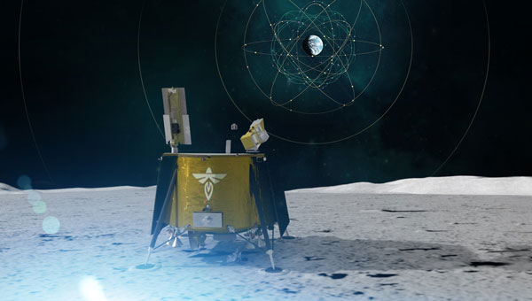
NASA and the Italian Space Agency (ASI) are collaborating on the Lunar GNSS Receiver Experiment (LuGRE), which seeks to demonstrate the viability of providing positioning, navigation and timing capabilities on the moon using GPS and Galileo signals.
LuGRE’s payload consists of a weak-signal GNSS receiver, a high-gain L-band patch antenna, a low-noise amplifier and an RF filter. The receiver is designed to track GPS L1 C/A and L5 signals, as well as Galileo E1 and E5a signals. It will collect pseudorange, carrier phase and Doppler measurements, calculate onboard navigation solutions, and have the capability to record raw I/Q baseband samples for ground processing.
NASA‘s Space Communications and Navigation (SCaN) Program office funded and oversaw the experiment. It was selected as one of ten research and technology demonstrations for lunar surface delivery by Firefly Aerospace, under NASA’s Commercial Lunar Payload Services (CLPS) initiative.
LuGRE builds upon previous missions in the Space Service Volume, including experiments by AMSAT-OSCAR 40, GOES-R series satellites and the NASA Magnetospheric Multiscale mission. It aims to be one of the first demonstrations of GNSS signal reception and navigation in the lunar environment, potentially paving the way for operational use in future lunar missions.
The target launch date for the Blue Ghost 1 mission carrying LuGRE is Jan. 15, 2025. Upon completion, all LuGRE science data will be made available to the public for the benefit of the GNSS and space communities.
L3Harris Technologies has received a contract from the U.S. Space Force’s Space Systems Command to develop design concepts for Phase 0 of the Resilient Global Positioning System (R-GPS) program.
This initiative aims to enhance the existing GPS constellation by integrating cost-effective small satellites, providing increased resilience for both military and civilian users. The R-GPS program seeks to augment the current 31-satellite GPS constellation with up to eight additional satellites. The new satellites are designed to counter various threats, including jamming, spoofing and more, ensuring uninterrupted positioning, navigation and timing (PNT) services.
L3Harris has provided navigation technology for all U.S. GPS satellites launched to date. The company has also contributed to the development of control systems and monitoring receivers and user equipment for GPS. This experience serves as the basis for their proposed R-GPS solution.
L3Harris is leveraging its investments in transformational PNT technology to meet the Space Force’s evolving requirements by using commercial form factors and interfaces to create a modular, scalable solution, the company said. Additionally, L3Harris is collaborating with the Space Force as the prime contractor for the experimental Navigation Technology Satellite-3 program, which focuses on developing innovative technologies and accelerating development timelines.
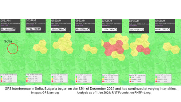
On Dec. 12, 2024, the European Union decided to include Bulgaria and Romania in the Schengen visa-free zone. On the same day, Bulgaria’s capital, Sofia, began experiencing interference with GPS signals. The interference, as reflected in aviation ADS-B systems and reported on GPSJam.org, continued through the new year and is ongoing as of this writing.
While these two events may be entirely unrelated, Vladimir Putin has a history of using GPS jamming and spoofing to show his displeasure with his neighbors growing closer to the West.
On Dec. 15, 2023, Poland activated a U.S. Aegis anti-missile system near its border with Kaliningrad, Russia. On the same day, Russia began jamming and spoofing GPS signals in northern Poland and parts of the Baltic. That interference persists to this day.
The interference in Sofia may be contributing to a prolonged Bulgarian political crisis. Politicians there have been struggling to form a new government since elections in October. Dec. 10 saw the beginning of a new attempt. Interference with GPS can undermine overall confidence in government systems and institutions — another of Putin’s goals for neighbors with whom he is displeased.
Another, though less likely, impact may be on Bulgaria’s electrical service. On Dec. 25, 2024, 20,000 households in western Bulgaria (Sofia is in the far west) lost electrical power and the outage continued for days. Many grid operators use GPS timing to help manage their systems. While press reports put the outages down to heavy snow and fallen trees, increased difficulty managing the grid might also be a factor.
Bulgaria’s GPS interference appears to be coming from somewhere in Sofia, not from Russian territory, as is the case in the Baltic. Yet Russia may still be involved, at least in a supporting role.
The European Space Agency (ESA) will host the first FutureNAV Industry Day on Feb. 18, 2025 — at ESTEC, the Netherlands — to address the growing demand for advanced positioning, navigation and timing (PNT) technologies. This event aims to bring together European stakeholders in satellite navigation to discuss future developments and foster collaboration within PNT and GNSS sectors.
As the leading system developer and design authority for Galileo and EGNOS, ESA plays a crucial role in Europe’s satellite navigation landscape. The agency launched the FutureNAV program in 2022 to unify efforts in advancing navigation technologies. Two key missions under this initiative are low-Earth orbit (LEO) PNT, which will demonstrate the potential of navigation satellites in LEO and Genesis, which will combine four geodetic techniques in one satellite to improve Earth’s reference frame.
FutureNAV Industry Day seeks to provide attendees with insights into ESA navigation plans and potential opportunities for European industry. It will follow a Request for Information on LEO-PNT industrialization, gathering information on European production capabilities for payload building blocks and satellite platforms.
To complement these upstream initiatives, the Navigation Innovation and Support Programme (NAVISP) Industry Days will be held at the University of London on March 4-5, 2025, focusing on downstream applications and bringing together industry leaders and innovators.
Click here to register and learn more about the event.
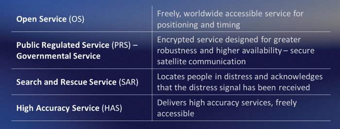
Galileo is Europe’s civil global navigation satellite constellation and a major success of the European Union (EU). It provides the world’s most precise satellite navigation performance. Galileo services began in December 2016 and are currently supplied to more than 3 billion users. They offer several high-performance services worldwide, featuring various levels of accuracy, robustness, authentication and security.
Galileo is a key component of mass-market applications for such areas as transport, agriculture and timing but also for security-critical applications, such as health services, emergency and rescue services and law enforcement. Galileo services continue to expand with many new capabilities that are unique with respect to other GNSS.
The European Union Agency for the Space Programme (EUSPA) and the European Space Agency (ESA) continue to collaborate effectively on the many developments, deployments and evolution activities of the Galileo Programme, each according to their respective responsibilities for exploitation and system development, with the European Commission acting as the program manager.
Stable Service Performance
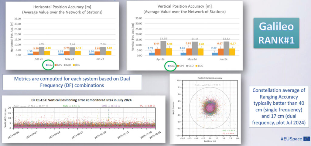
Galileo services continue to deliver excellent performance every month in a safe, secured and seamless manner, managed by EUSPA. The performance parameters of the Galileo services are independently monitored by the Galileo Reference Centre (GRC) and are regularly published on the web portal of the GNSS Service Centre (GSC): gsc-europa.eu.
The performance of the Open Service (OS) remains “Best in Class” among the GNSS providers. Timing users also continue to receive accurate (in the order of 5 ns) access to Galileo System Time, which they can trace to Universal Coordinated Time (UTC) through the corresponding offset parameters transmitted by the satellites.
The Search and Rescue (SAR) service was delivered well beyond the commitment to the users, for both forward and return link services, while the High Accuracy Service (HAS) and the Public Regulated Service (PRS) continue being provided as planned in the corresponding Service Definition Document (SDD).
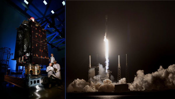
Following weather delays, the U.S. Space Force’s Space Systems Command (SSC) and Space Operations Command expedited the Rapid Response Trailblazer launch schedule to fulfill a specific warfighter requirement. On Dec. 16, 2024, SpaceX’s Falcon 9 rocket launched the GPS III SV-07 satellite from Space Launch Complex 40 at Cape Canaveral Space Force Station, Florida.
For the mission, multiple Space Force organizations collaborated to retrieve an existing GPS III satellite from storage, expedite integration and launch vehicle preparation, which was quickly processed for launch. The success of the launch proved a two-fold concept of operations. SSC’s Assured Access to Space showcased its agility in partnering with industry to meet evolving national needs, completing a National Security Space class launch in less than five months.
This marks the first Space Operations Command mission led by Mission Delta 31 for a Space Vehicle launch, and it demonstrated exceptional flexibility by reducing the typical six-month pre-launch processing timeline to approximately three months, Space Operations Command said. This effort involved close coordination with Lockheed Martin in Colorado to rapidly prepare SV-07 for launch.
The GPS III SV-07 satellite joins a robust constellation comprising 31 active vehicles, seven in reserve status and three completed GPS III vehicles awaiting launch. Equipped with M-Code technology, these satellites offer improved anti-jamming and anti-spoofing capabilities, enhancing secure access to military GPS signals for U.S. and allied forces.
VIAVI Solutions has signed an agreement to acquire Inertial Labs for $150 million. The acquisition, subject to certain regulatory approvals and customary closing conditions, is expected to close in the third quarter of fiscal 2025 and has a potential for up to $175 million in contingent payments throughout the next four years.
This acquisition is expected to significantly boost VIAVI’s financial performance, with projections indicating an increase of approximately $50 million to the company’s Network and Service Enablement (NSE) annual revenue in 2025. Inertial Labs brings to VIAVI a comprehensive portfolio, including inertial measurement units (IMU), inertial navigation systems (INS), assured positioning navigation and timing (APNT), GNSS tracking, lidar scanning, alternative navigation (ALTNAV) and visual navigation solutions. These offerings complement VIAVI’s existing PNT and other aerospace and defense solutions.
According to VIAVI Solutions, the acquisition is designed to open up new opportunities for VIAVI in emerging markets. Inertial Labs’ expertise in utility inspection through lidar and photogrammetry algorithms, as well as smart system navigation for airborne and autonomous ground vehicles, is expected to accelerate VIAVI’s entry into industrial and autonomous delivery and transportation end markets.
“With a highly complementary product portfolio focused on alternate navigation solutions, this transaction supports VIAVI’s strategy to expand our presence in domestic and international aerospace and defense segments and accelerates our entry into autonomous air, land and sea systems in the military and industrial end markets,” said Oleg Khaykin, president and CEO of VIAVI.
“We are excited that our expertise, precision solutions and resources provide expansion opportunities for VIAVI in high growth markets and applications such as drone-based lidar and camera systems,” said Jamie Marraccini, president and CEO of Inertial Labs.
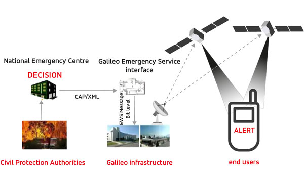
The European Union Agency for the Space Programme (EUSPA) has awarded GMV a framework contract to deliver new Galileo functionalities under the EmeRgency Alerting System (ERAS). This four-year contract, valued at approximately $6 million, will enable significant advancements in Europe’s disaster response capabilities. The GMV-led consortium includes Ineco, ALTEN Spain and Kineton as subcontractors.
ERAS will primarily allow Member States’ National Civil Protection Authorities to broadcast emergency warning messages directly to populations in at-risk or affected areas. These alerts will be transmitted via Galileo satellites to smartphones and other Galileo-enabled devices. According to EUSPA, the messages will contain crucial information about the hazard, including its type, severity, affected area, expected onset and duration, as well as guidance for appropriate responses.
The Galileo Emergency Warning Satellite Service (EWSS) and ERAS seek to enhance Galileo by offering resilience and complementarity to existing public warning systems, independence from terrestrial and mobile networks, rapid communication with global reach and particular benefits for remote areas with limited mobile coverage.
The system is designed to provide a robust and versatile solution for emergency communications, ensuring that critical alerts reach populations even in challenging scenarios. ERAS is expected to be fully operational in the first half of 2026.
The implementation of ERAS comes at a critical time, as highlighted by the State of the Climate in Europe (ESOTC) report for 2024. Europe has experienced numerous extreme weather events in recent years, including heat waves, forest fires, floods and droughts. The continent is warming at approximately twice the global average rate, emphasizing the urgent need for effective warning systems and robust climate policies, GMV shared.
The joint use of Galileo ERAS and the Copernicus Emergency Management Service seeks to enhance the European Union’s and its Member States’ disaster management capabilities. This integration will provide a comprehensive approach to alerting populations about risks such as the recent disasters in Valencia, Spain and other parts of Europe.
China’s BeiDou satellite navigation system (BDS) has secured approximately $1.78 billion in funding for new projects, positioning itself to compete more effectively with its primary rival, GPS. This significant financial boost was announced at the Third International Summit on BDS, coinciding with the system’s 30th anniversary.
The investment package includes $1.1 billion, which is designated for adopting BeiDou in both industrial and consumer applications, according to Hunan Daily. Part of the funding has been allocated to an Indonesian disaster prevention agency for the development of an early warning system.
China’s Ministry of Industry and Information Technology has also selected 39 pilot cities for large-scale BDS applications. These cities are expected to increase BDS usage rates as the system transitions into its third-generation phase. This aims to expand BeiDou’s domestic footprint and showcase its capabilities on a broader scale, according to China’s Ministry of Industry and Information Technology.
BeiDou is gaining traction in Africa and Southeast Asia, which could challenge GPS’s long-standing dominance. As more countries adopt the Chinese system as their primary GNSS, BeiDou’s prominence increases compared to GPS. China launched two new satellites in Sept. 2024, bringing the total number of active satellites in the BeiDou constellation to 50. These newly launched satellites, part of the third-generation model, represent the second batch placed into medium-Earth orbit (MEO) since the system was declared operational in July 2020. With 64 satellites launched, China continues to expand and enhance the BeiDou system.
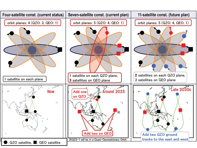
Japan’s Cabinet Office (CAO) is currently developing the Quasi-Zenith Satellite System (QZSS) seven-satellite constellation (7SV-const.)
Japan’s cabinet revised our new basic space policy plan on June 13, 2023. It states that the number of QZSS satellites should be increased from seven to 11 to improve stability and reliability as one of the social infrastructures by securing backup function for coming full-scale use and to reduce the dilution of precision (DOP).
On June 12, 2024, the National Space Policy Secretariat revised the action plan for the satellite positioning system for the first time in three years. According to this plan, the completion of the QZSS 11-satellite vehicle constellation is anticipated by the late 2030s.
Figure 1 System expansion of QZSS.
Brief History of QZSS
Since 2006, the Ministry of Education, Culture, Sports, Science and Technology (MEXT), the Japan Aerospace Exploration Agency (JAXA), the Ministry of Internal Affairs and Communications (MIC), the Ministry of Economy, Trade and Industry (METI) and the Ministry of Land, Infrastructure, Transport and Tourism (MLIT) have collaborated to develop the world’s first centimeter-level positioning satellite.
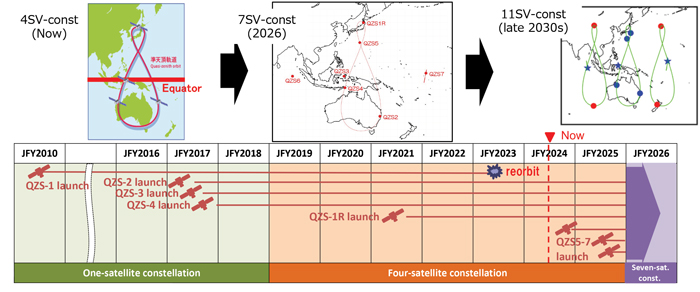
The first QZS satellite was launched in September 2010, for what was then envisioned as a four-satellite regional satellite navigation system, also known as MICHIBIKI. In September 2011, the Cabinet approved a plan to build the four-satellite constellation (4SV-const.) in the late 2010s, with the goal of building a 7SV-const. in the future. The budget was approved in JFY2012 to promote this as a national project.
In 2017, QZS-2, 3 and 4 were successfully launched and a 4SV-const. was established. On Nov. 1, 2018, QZSS officially began service. On Oct. 26, 2021, the successor to the first MICHIBIKI was launched.
Development is underway to launch three additional satellites for the 7SV-const. sequentially from JFY2023 to JFY2024, depending on the development status of the H3 launch vehicle.
To improve resilience for more stable positioning and improved DOP, CAO has started a study to transition from a 7SV-const. to an 11SV-const. (See Figures 1 and 2)
Figure 2 QZSS Constellation Expansion Plan.
Service Overview
The 4SV-const. provides GPS Complementary Service (PNT service); GNSS Augmentation Service, i.e. Sub-meter Level Augmentation Service (SLAS), Centimeter Level Augmentation Service (CLAS), MADOCA-PPP and satellite-based augmentation service (SBAS), as well as a messaging service.
The QZSS constellation consists of a geostationary orbit (GEO) satellite, QZS-3 and three QZO satellites.
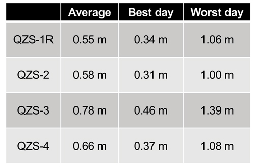
QZSS’s performance of the positioning, navigation and timing (PNT) service and signal-in-space user range error (SIS-URE) was much better than specified. Evaluation results are shown in Table 1.
The evaluation period was “08/01/2023#07/31/2024.” The specification is less than 2.6 m (95%).
Toward Seven-Satellite Constellation
Three additional satellites will be positioned in an inclined geostationary synchronous orbit (IGSO) at 90.5° east longitude and in a quasi-geostationary orbit at 175° west Longitude. This constellation is designed to ensure that multiple satellites are visible at high elevation angles, with the goal of having more than four satellites visible for extended periods of time, ultimately improving the DOP.
The positioning signals of 7SV-const. are shown in Table 2. QZS 5 to 7 transmit L1C/B.
Table 1 Performance of the QZSS PNT service.
After the QZS-5 service starts, QZS1R’s signal will switch from L1C/A to L1C/B. The QZSS Navigation Message Authentication (QZNMA) service for other GNSS is included in L6E signals.
QZS5-7 development is ongoing. A system-level test is in progress. The plan is to launch QZS 5-7 around 2025. QZS-5 and 6 have almost finished the system-level test. QZS-7 finished the electrical test, and now it is in the environmental test phase.
QZSS antenna patterns for SSV users, published since Aug 2023, correspond to the ICG WG-B recommendation “Release of GNSS Transmit Antenna Patterns Including Side Lobes,” submitted on Dec. 11, 2019.
The QZSS ground system, capable of operating with seven satellites, was completed in August 2023. The only remaining task is to conduct compatibility tests between the satellites and the ground radio frequency. The QZSS ground system consists of two master control stations located in Hitachi-Ota and Kobe, as well as 10 satellite tracking and control stations (telemetry, tracking and command stations), primarily situated in the southwestern islands. Additionally, there are more than 30 monitoring stations worldwide, established in cooperation with various countries.
The following additional services began this year or will begin next year:
Users obtain position, velocity, and time (PVT) solutions using ranging signals provided by the 7-SV const. The Navigation Message Authentication (NMA) began in April 2024.
Multi-GNSS Advanced Orbit and Clock Augmentation — Precise Point Positioning (MADOCA-PPP) covers a major part of the Eastern Hemisphere and provides PPP error corrections on the L6 signal. It enables highly precise positioning by providing augmentation data to correct some GNSS errors and provides two service levels, i.e., (a) global-PPP and (b) fast-PPP with ionospheric correction.
Operational service started on April 1, 2024 and Internet distribution of MADOCA-PPP in July 2024.
Expanded Satellite Report for Disaster and Crisis Management (DC report), Early/Emergency Warning Satellite Service (EWSS).
Figure 3 MADOCA-PPP service evaluation results.
In addition to the current DC report service generated by the Japan Meteorological Agency, other disaster-related reports, called L-alert and J-alert, such as an evacuation order, began on April 1, 2024.
The Global PPP service provides highly precise positioning where QZSS L6E signals can be received.
It provides satellite-dependent error corrections (orbit, clock, code/phase bias) by QZSS L6E signals.
Faster PPP using observation data from regional/nationwide Continuously Operating Reference Stations (CORS). In addition to global PPP, QZSS L6D (QZS-6 and 7) signals will provide regional error corrections (ionospheric correction).
MADOCA-PPP began operational service on April 1, 2024. For MADOCA’s stable operation, the GNSS Integrated Data Sharing System (MIRAI) was released in April 2022. The ionospheric correction data will be broadcast to reduce the initial convergence time starting in 2025.
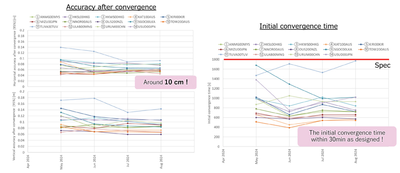
MADOCA-PPP service was defined and described on PS-QZSS 003, published on March 17, 2022. Internet distribution of MADOCA-PPP, including ionospheric correction data, began in July 2024 to promote MADOCA-PPP utilization. MADOCALIB, test library of MADOCA-PPP, has been open-sourced and made available on GitHub this April, and updated to process ionospheric correction data in July 2024. MADOCA-PPP performance results from May to August 2024 using IGS monitoring station are shown in Figure 3.
Better initial convergence time than the defined specification and approximately 10 cm of accuracy are confirmed.
Thanks to the cooperating countries, ionospheric correction data can be generated, and the initial convergence time reduction was confirmed in all areas.
CAO started the Internet distribution, including the ionospheric correction data for these areas.
Figure 4 QZSS applications.
QZNMA
QZNMA began on April 1, 2024, to enhance the constellation’s resilience against spoofing attacks.
Navigation messages in the following signals are authenticated using the Elliptic Curve Digital Signature Algorithm (ECDSA P256).
■ QZSS signals (L1C/A(C/B), L1C, L5) are directly protected by self-authentication.
■ GNSS signals (GPS: L1C/A, L1C, L5, Galileo:E1b, E5a) are protected by cross-authentication (L6E).
As of September 2024, approximately 434 products are compatible with QZSS (See Figure 4). New applications such as autonomous driving, drone operations and buoys for real-time ocean tide monitoring are emerging. We expect that many applications and devices using QZSS will emerge. We appreciate your cooperation and support of QZSS.