NATO has selected SandboxAQ as one of approximately 70 companies to participate in the 2025 Defense Innovation Accelerator for the North Atlantic (DIANA) cohort. The selection process involved more than 2,600 submissions from 32 NATO countries. DIANA, established by NATO in 2023, aims to address complex societal challenges by bringing together innovative companies developing dual-use technologies for both commercial and defense applications.
SandboxAQ will join the cohort’s Sensing & Surveillance group, focusing on the development of its AQNav magnetic navigation system. AQNav is designed to provide a secure navigation alternative that does not rely on GNSS, making it resilient against jamming and spoofing. The system utilizes SandboxAQ’s proprietary Large Quantitative Models (LQMs), quantum sensors, and the Earth’s crustal magnetic field to offer an all-weather, day and night, terrain-agnostic navigation solution for military and commercial applications.
The AQNav system has undergone extensive testing, including more than 200 hours of flight tests with the U.S. Air Force, involving more than 40 sorties across various geographies and aircraft types1. In July 2024, AQNav demonstrated its capability to serve as a primary navigation source and showed potential for scalability across similar aircraft types without individual calibration.
As part of the DIANA program, SandboxAQ will receive resources, insights and developmental support to advance AQNav’s capabilities. The company will also have opportunities to test the system in specialized environments, leveraging DIANA’s network of experts in technology, commercial development and defense.
Iridium Communications is exploring the potential use of small satellites to demonstrate advanced positioning, navigation and timing (PNT) capabilities.
Iridium CEO Matt Desch discussed this initiative during the Smallsat Symposium in Silicon Valley, where he suggested the company might venture into the smallsat business, even if only for experimental purposes.
Desch said small satellites could also support the development of a very-high frequency (VHF) radio system aimed at enhancing pilot communications with Aireon, a provider of aircraft surveillance services using hosted payloads on Iridium’s satellites.
Iridium operates a constellation of 66 Iridium Next spacecraft in low-Earth orbit (LEO) for L-band connectivity services, along with additional spare satellites. Following an engineering assessment in 2024, the company expects this constellation to remain operational until at least 2035.
The Iridium Next satellites, weighing approximately 860 kg, are significantly larger than typical small satellites used for LEO communications, which generally range from a few dozen to a few hundred kilograms. While smaller satellites offer advantages in terms of faster and more cost-effective deployment for specific missions, Iridium’s larger satellites are designed for extended operational life, supporting its global, cross-linked network.
The European Union Agency for Space Programme (EUSPA) has released its first GNSS and secure satellite communications (SATCOM) user technology report, offering an overview of recent developments in GNSS and SATCOM. This publication combines and expands upon previous GNSS user technology and secure SATCOM market and user technology reports, offering a comprehensive look at current trends and advancements in user technology.
The report examines the satellite industry’s ongoing transformation, influenced by evolving security concerns, increased digitalization efforts, rapid progress in artificial intelligence (AI) and the emergence of the New Space sector. By addressing these topics, the report aims to provide stakeholders with up-to-date information on the state of satellite-based technologies.
Focusing on both GNSS and Secure SATCOM, the publication explores recent innovations in user technology, such as terminals and receivers. It also investigates potential synergies between these two fields. This approach allows readers to gain insights into how these technologies are developing in parallel and potentially converging in certain applications.
Developments and trends in GNSS technology
The report opens with a summary of the recent developments and future trends in GNSS technology that are relevant to end users. As new GNSS frequencies and signals become available for civilian applications, receiver manufacturers have been upgrading their products to accommodate satellites in medium-Earth orbit (MEO). The international coordination among GNSS supports this advancement, Radio Navigation Satellite Service, and Satellite-Based Augmentation System providers, resulting in the adoption of open access signals with compatible frequency plans, common multiple access schemes and modulation schemes.
The report states that a service-oriented approach to GNSS is emerging, building upon existing infrastructure to offer users enhanced performance and security. The European GNSS program has made significant strides in this area, backed by the recent implementation of the Galileo High Accuracy Service (HAS) and Open Service Navigation Message Authentication (OSNMA) feature. The Report gives insight into emerging technologies and upcoming innovations, focusing on key trends in receiver electronics design and signal processing aimed at improving performance or reducing power consumption. Multi-frequency capabilities, PNT processing strategies and advances in antenna design are identified as key drivers shaping the future of GNSS receiver technology, according to EUSPA.
Among other topics selected, the spoofing and jamming threats are becoming a priority to be addressed both at the system and user level. Solutions such as Galileo OSNMA authentication and more resilient receivers with multiple antennas and sensor hybridization are being explored and are starting to be implemented.
Developing secure SATCOM systems
The secure SATCOM section of the Report outlines trends in the secure SATCOM domain by emphasizing enhanced performance and system management optimization. It specifically highlights how digitalization processes, cloud environments and AI techniques are enhancing performance and system management optimization in the secure SATCOM domain. It also notes the ongoing efforts to standardize the integration of non-terrestrial networks into the 5G ecosystem.
According to EUSPA, the deployment of large Non-Geostationary Orbit (NGSO) constellations aims to improve performance, particularly in reducing transmission latency. These systems rely on advanced user terminals capable of tracking and switching between multiple fast-moving satellites across the sky.
The report also emphasizes security in SATCOM transmissions, recognizing that satellite communications encounter similar threats from malicious signals as terrestrial communications. Consequently, both governmental and commercial SATCOM systems are being developed with a rising focus on enhancing the confidentiality, integrity, and availability of both governmental and commercial SATCOM systems links.
It also describes a shift in SATCOM systems from legacy hardware-centric designs to modern software-oriented solutions. This digital transition allows user terminals to utilize multiple constellations and frequencies, which significantly improves the availability of communication links. This can help mitigate disruptions caused by natural factors or intentional interference.
Exploring potential and existing synergies
The report concludes with an examination of existing synergies between GNSS, secure SATCOM, and Earth observation (EO). Notable examples include the transmission of EO data through SATCOM systems, utilizing GNSS for operating NGSO SATCOM terminals, the complementary use of GNSS and secure SATCOM in transport and emergency management, remote sensors used by Copernicus — a European EO program — that rely on both GNSS and SATCOM and high-accuracy GNSS positioning in remote areas enabled by SATCOM.
From Dec. 4-5, 2024, the National Space-Based Positioning, Navigation and Timing (PNT) Advisory Board met to discuss GPS-related topics. The PNT Advisory Board provides independent advice to the U.S. government on GPS-related policy, planning, program management and funding profiles in relation to the current state of national and international satellite navigation services. A March 28, 2024, GPS World article by Dana Goward highlighted that the PNT Advisory Board has been providing the government with independent expert advice about GPS and PNT for 20 years. He highlighted that the Board is chaired by retired Admiral Thad Allen and has six subcommittees.
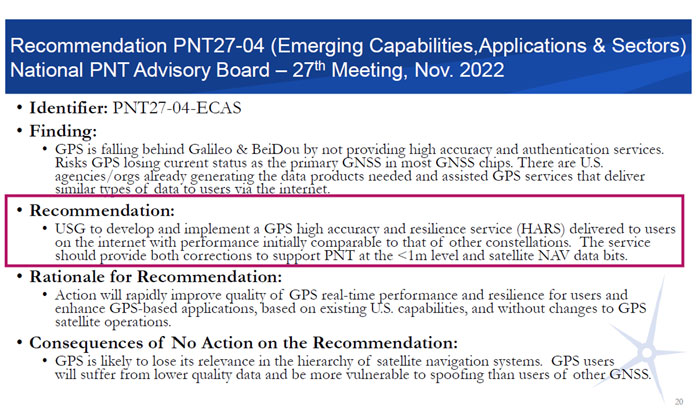
This newsletter will highlight a topic that the emerging capabilities, applications and sectors subcommittee discussed at the final PNT Advisory Board meeting of 2024. The presentation title is “GPS High Accuracy and Robustness Service (HARS).” A white paper on the topic and the Dec. 4, 2024, presentation by Shachak Pe’eri, Ph.D., NOAA/NOS/National Geodetic Survey (NGS), can be found on the PNT Advisory Board website.
According to the document, the board prepared the white paper to support recommendation number PNT27-04-ECAS, which is to develop and implement a GPS HARS delivered to users via the Internet. The HARS concept was approved at the PNTAB-27 meeting (Nov. 16-17, 2022) and formally submitted to the National Space-Based PNT EXCOM co-chairs via Memorandum on Jan. 27, 2023.
Recommendation PNT27-04. (Photo: Presentation by John W. Betz, PhD Member, National Space‐Based PNT Advisory Board on May 29, 2024)
The November and December Advisory Board meetings are recorded, and individuals can listen to the entire meeting. The Board’s website provides links to the meeting agenda and presentations. Pe’eri’s presentation on HARS started at 10:30 am on Dec. 4 (2:04 on the recording).
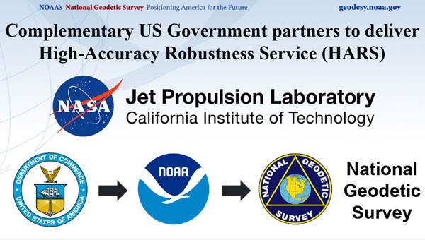
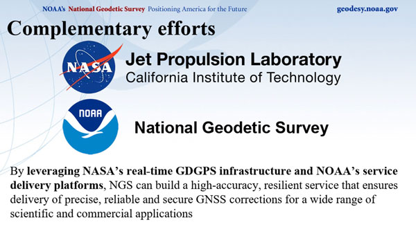
During the meeting, the PNT Advisory Board officially stated that it supports the HARS Concept described by NOAA. Of course, the Board also stated that it has no money, but the Board’s stamp of approval of the concept is very important. Now, it is up to NOAA’s NGS to work with other federal agencies, such as NASA’s Jet Propulsion Laboratory (JPL), to work out the details and resources. By leveraging NASA’s real-time Global Differential GPS (GDGPS) System infrastructure and NOAA’s service delivery platforms, a high-accuracy, resilient service that ensures delivery of precise, reliable and secure GNSS corrections for a wide range of scientific and commercial applications can be built for the nation.
So, what exactly is the GPS High Accuracy and Robustness Service (HARS)? The following is a statement from a Jan. 27, 2023, PNT Memo:
“Implementing a GPS High Accuracy and Robustness Service: To augment GPS and overcome some inherent limitations of space-based PNT, the USG should provide a service comparable to the European Union’s Galileo HAS that provides signal corrections than enable better than one-meter level accuracy, as well as cryptographically-protected satellite navigation message data bits for integrity processing. The U.S. should develop and implement GPS HARS, based on the capabilities developed by the JPL for GDGPS, to be made available to users over the Internet.”
The white paper describes the problem and the solution as the following:
“The problem: GPS is falling behind other Global Navigation Satellite Systems (GNSSs) such as Europe’s Galileo and China’s Beidou. GPS has adopted an approach of allowing augmentation by third-party systems (such as Assisted-GNSS in mobile phones, WAAS for aviation accuracy and integrity, and commercial RTK for precision users), rather than providing specialized advanced services itself. Also, the data message modulated on the GPS signals is fragile. Environmental effects or malicious actions can prevent a receiver from reading the information or manipulate what is read, limiting the robustness of the GPS signals. Currently, GPS is the primary system in almost all GNSS chips, even chips made in Europe or Asia. That is: chips are designed to acquire GPS signals first, then signals from other systems. But Galileo and BeiDou are deploying high accuracy services that provide sub-meter position accuracy, enhancing satnav use in many civil applications. The absence of any plan for GPS to offer a similarly high accuracy service could cause GNSS chips to begin using Galileo or BeiDou, rather than GPS, as the primary system. A switch away from GPS as the primary PNT system is a problem for the US Government because it will lose its strategic advantage. Existing commercial chips are used in many strategically important US assets, such as airlines, ships, and organizations that support the US military. Once these chips change their architecture to Galileo-first or BeiDou-first, these strategic use cases depend on these services. It is one step in the direction of not having a GNSS system at all and borrowing the system of another power, exactly the situation that Europe and China were in before they built their own systems. GPS would no longer be the “pre-eminent space-based PNT service” called for in Space Policy Directive 7.”
“The Solution:A high accuracy and robustness service (HARS) provides information to user receivers, reducing errors and enhancing the ability to operate in challenging conditions. The PNT Advisory Board has identified a solution that the U.S. government can provide a HARS without adding cost and complexity to GPS itself; instead, the needed information from government or government-sponsored organizations can be obtained and provided over the Internet to properly equipped receivers. The result would be a world-class HARS at a small fraction of the cost or time, compared to implementing it on new GPS satellites. The HARS would provide cryptographically-protected robust (resistant to jamming and spoofing) GPS for critical infrastructure and would enable new applications (such as lane-dependent route guidance in automobile navigation and emergency vehicle guidance, GPS-only precision positioning of drones) that extend the societal benefits of GPS. HARS would be secure and less sensitive to radio noise and disruptions, including spoofing.”
The following are a few slides from Pe’eri’s presentation highlighting the need for HARS. He mentioned that there are six regional high accuracy systems and one global service that is already operational or in development.
Six regional HAS and one global HAS are operational or in development at this time. (Photo: NOAA/NGS)
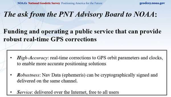
NOAA’s presentation by Pe’eri was in response to a request by the Advisory Board. The Board was interested in learning more about the funding and operating a public service that can provide robust real-time GPS corrections. Summarized in three bullets:
High-Accuracy: Real-time corrections to GPS orbit parameters and clocks to enable more accurate positioning solutions.
Robustness: Nav Data (ephemeris) can be cryptographically signed and delivered on the same channel.
Service: Delivered over the Internet and is free to all users.
The HARS could be accomplished by employing the expertise, knowledge, and capabilities of NASA’s JPL and NOAA’s NGS.
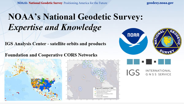
NOAA has the authority to provide real-time operational services and regularly collaborates with other federal and state agencies and local communities. NGS manages and distributes the NOAA CORS Network (Foundation and Cooperative CORS). NASA JPL collects GNSS data and generates products with high accuracy.
NGS expertise and knowledge. (Photo: NGS/NOAA)
NASA’s GDGPS is a complete, highly accurate and extremely robust real-time GNSS monitoring and augmentation system. The CCDIS website states, “Employing a large ground network of real-time reference receivers, innovative network architecture, and real-time data processing software, the GDGPS System provides sub-decimeter (<10 cm) positioning accuracy and sub-nanosecond time transfer accuracy anywhere in the world, on the ground, in the air, and in space, independent of local infrastructure.”
JPL expertise and knowledge. (Photo: NASA)
By leveraging NASA’s real-time GDGPS System infrastructure and NOAA’s service delivery platforms, NGS and JPL can build a high-accuracy, resilient service that ensures delivery of precise, reliable and secure GNSS corrections for a wide range of scientific and commercial applications.
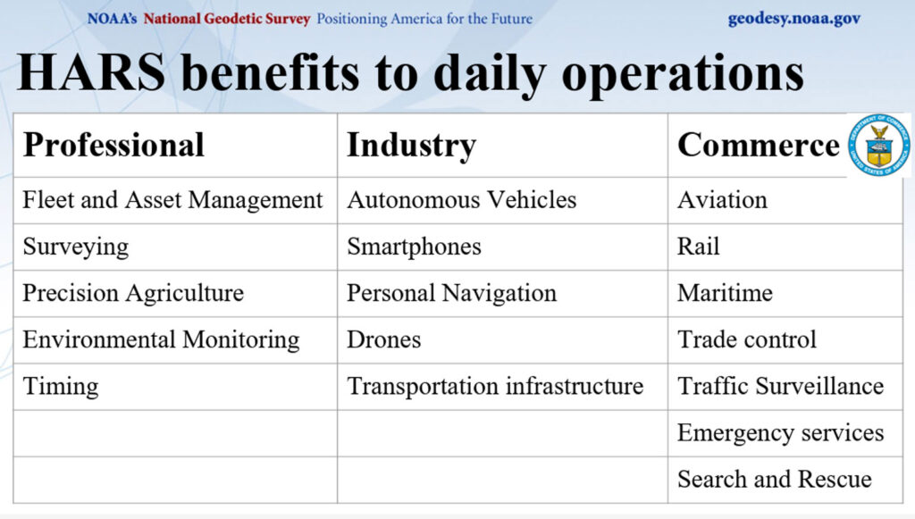
Pe’eri’s presentation highlighted HARS benefits to the daily operations of users of geospatial data.
HARS benefits for users. (Photo: NOAA/NGS)
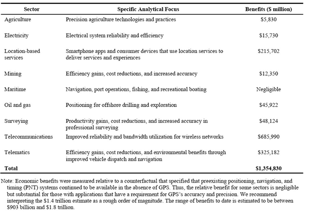
The HARS concept is extremely important to the U.S. GPS user community, where the number of users is increasing every day. A 2019 Department of Commerce (NIST) study, “Economic Benefits of the Global Positioning System (GPS),” highlighted the economic damages a GPS outage would have on the agricultural industry.
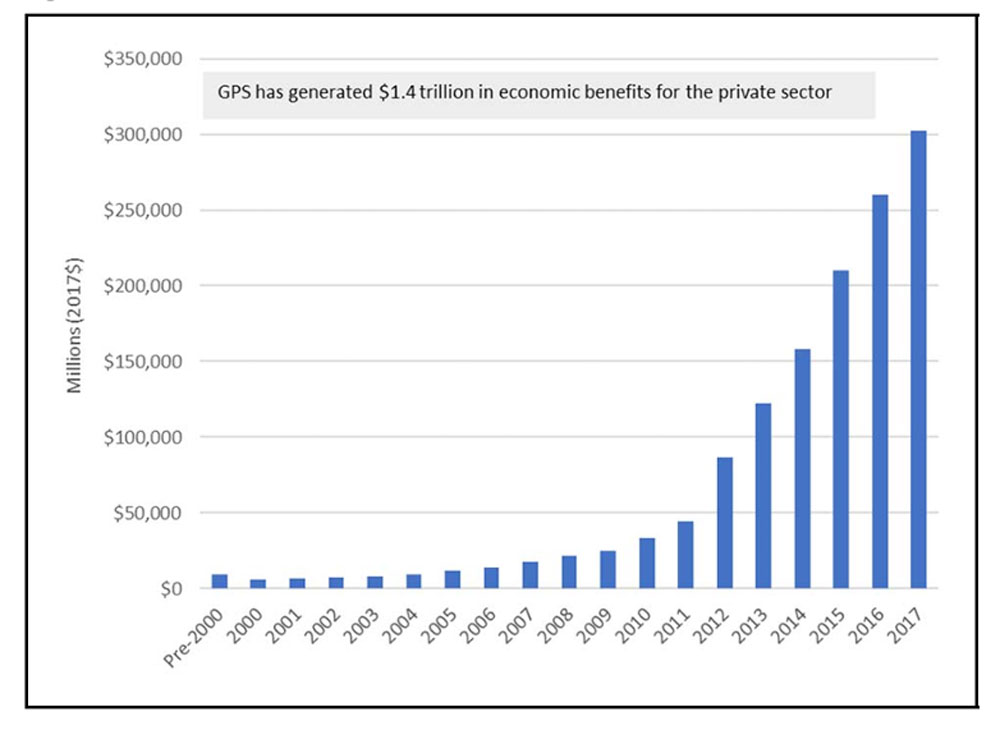
The 2019 NIST study, “Economic Benefits of the Global Positioning System (GPS),” determined that $1.4 trillion in U.S. economic benefits from GPS. The study stated that a 30-day widespread outage could erode less than $1 billion in economic value per day. The study also highlighted the impact a GPS outage would have on Agriculture, stating that during planting season, economic damages in the agriculture sector could increase 30-day losses to $15 billion due to lower yields.
Table ES-1 and figure ES-1 from the 2019 report highlight the economic benefits of GPS for private sector use.
Table ES-1: Summary of economic benefits of GPS for private-sector use, 1984 to 2017. (Photo: NIST) Figure ES-1: Time series of GPS’s economic benefits for the private sector. (Photo: NIST)
I would encourage others to look at the PNT website, especially the Advisory Board website, to obtain information about space-based PNT. Other recommendations and letters from the Advisory Board to the Executive Committee (EXCOM) can be found on the PNT and Advisory Board websites. The webpage provides the Advisory Board’s recommendations on ways to improve GPS and national GPS management. The recommendations are published in the interest of public transparency.
The European Union Agency for the Space Programme (EUSPA) has selected GMV to develop a new version of the High Accuracy Data Generator (HADG) as part of Phase 2 of the Galileo High Accuracy Service (HAS) development.
This service offers free real-time precise positioning corrections to all Galileo system users. The first version of the HADG, also developed by GMV, is currently operational and provides users with the Initial Service (Phase 1) of the HAS.
The new contract spans up to 45 months and has a budget of up to €12 million. It covers the design, development, deployment, and support to commissioning, along with optional maintenance of an enhanced version of the HADG. This updated version will integrate the functionalities necessary for providing the services outlined in Phase 2 (Full Service) of the HAS deployment.
The new version of the HAS data generator seeks to improve the performance level of Service Level 1 (SL1) by deploying a new version of GMV’s magicPPP algorithms for precise corrections calculation and expanding the ground station network. This aims to provide global coverage and enhance the accuracy and availability of the SL1 service. Additionally, it will implement a new Service Level 2 (SL2), a regional service available only in Europe that will transmit atmospheric corrections to reduce the convergence time required to achieve maximum accuracy at the user level.
Another key feature of the new HADG version is the implementation of a new functionality for the authentication of HAS corrections transmitted through the Galileo constellation, thereby increasing user security and confidence in the service.
Since 2020, GMV has led the development of the Galileo HAS data generator following the award of the first contract with EUSPA. Since its operational launch in January 2023, the Galileo HAS service has provided accuracy for advanced applications in sectors such as navigation, agriculture, geodesy, and autonomous driving. In the new contract, GMV maintains its role as the main contractor and leader of an industrial consortium that includes atmospheric modelling experts from the Polytechnic University of Catalonia (UPC) and cybersecurity specialists from Sidertia.
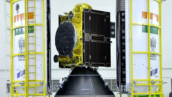
The Indian Space Research Organisation (ISRO) has encountered a significant setback with its recently launched NVS-02 navigation satellite. Launched on Jan. 28, 2025, the satellite is currently stranded in a transfer orbit due to a critical failure in its onboard propulsion system, ISRO stated in a report. The issue occurred when the valves admitting the oxidizer to fire the thrusters for orbit raising failed to open, which prevented the satellite from reaching its intended orbital position.
The NVS-02 satellite, part of India’s Navigation with Indian Constellation (NavIC) program, was launched using a Geosynchronous Satellite Launch Vehicle (GSLV) Mark II rocket from the Satish Dhawan Space Centre. The launch placed the satellite into a geostationary transfer orbit with a perigee of approximately 165 km and an apogee of approximately 37,582 km.
ISRO noted in its statement that other systems on the spacecraft were working well, including a successful deployment of its solar panels.
“The satellite systems are healthy and the satellite is currently in elliptical orbit. Alternate mission strategies for utilizing the satellite for navigation in an elliptical orbit are being worked out,” ISRO stated.
The space agency is now exploring alternative mission strategies to utilize the satellite for navigation in its current elliptical orbit. However, the low perigee of NVS-02 poses a significant risk, as it exposes the spacecraft to high atmospheric drag, potentially leading to an early reentry if the orbit cannot be raised.
NVS-02 is based on ISRO’s I-2K satellite bus, which has been used for other Indian communications and navigation satellites operating in geostationary orbit. The spacecraft had a launch mass of 2,250 kg.
The spacecraft was intended to operate at 111.75 degrees east in GEO, replacing the IRNSS-1E spacecraft there. It is the second of five satellites planned for India’s Navigation with Indian Constellation, or NavIC, program to provide positioning, navigation and timing services in India and the surrounding region. The first, NVS-01, launched in 2023 and operates in GEO.
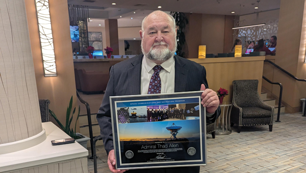
The National Space-Based Positioning, Navigation, and Timing Advisory Board continued its discussions on how best to protect, toughen and augment GPS at its 31st meeting, which took place Dec. 4-5 at the Sonesta Redondo Beach and Marina in Redondo Beach, California. The meeting was convened by James J. Miller, of NASA, who is the board’s executive director, and chaired by retired Adm. Thad Allen of the U.S. Coast Guard.
On the first day, after hearing reports from its six subcommittees, the board heard the following presentations:
Karen Van Dyke, director, PNT & spectrum management, Department of Transportation (DOT), on DOT’s IDM and complementary PNT work.
Maj. Christine Bonniksen, retired from the U.S. Air Force, deputy director for flight projects, NASA Langley Research Center, and Shachak Pe’eri, Ph.D., acting director, National Geodetic Survey, National Ocean Service, National Oceanic and Atmospheric Administration (NOAA), on NOAA’s implementation of a GDGPS-based GPS High Accuracy and Robustness Service.
Anh Nguyen, Ph.D., NASA flight opportunities program (Bryce Space and Technology, LLC) and Lisa Valencia, NASA Space Communications and Navigation Program (Overlook Systems Technologies, Inc.) on the SpaceLoft 15 multi-GNSS flight experiment (see the article on p. 16).
Allison Kealy, Ph.D., director of the Innovative Planet Research Institute, Swinburne University, Australia, on resilient PNT.
Brad Parkinson, Ph.D., the board’s first vice chair, on a comparison of GPS with the other GNSS.
Satoshi Kogure, senior chief officer of satellite navigation technology, Japan Aerospace Exploration Agency on Japan’s Quasi-Zenith Satellite System (QZSS).
Moon Beom Heo, Ph.D., executive director of KPS R&D Directorate, Korea Aerospace Research Institute on the Korean Positioning System (KPS).
Matt Higgins, international engagement subcommittee chair on Galileo.
Cordell DeLaPena, executive officer, MilComm & PNT, Space Systems Command, USSF on the status of the GPS program, including L5, OCX, civil signal monitoring, resilient-GPS and low-Earth orbit PNT.
On the second day, the board held a roundtable discussion, then heard updates from its international members and representatives. For video of the proceedings, go to youtube.com/@nationalpntboardmeetings822/streams.
To celebrate Allen’s long service as this board’s chair, NASA conferred a beautiful plaque to him, bearing the following text:
“PRESENTED TO Admiral Thad Allen
With our deepest gratitude, the NASA community and our many partners are very thankful for the friendship and dedicated leadership you have provided as the Chair of the National Space-Based Positioning, Navigation, and Timing Advisory Board. Your advocacy on behalf of GPS users worldwide will always be remembered and cherished. December 2024
Kevin Coggins
Deputy Associate Administrator, Space Communications and Navigation
NATIONAL AERONAUTICS AND SPACE ADMINISTRATION”
The Directorate of Defense Trade Controls (DDTC) has changed the regulatory status of Controlled Reception Pattern Antennas (CRPAs) for position, navigation and timing (PNT). Starting September 2025, CRPAs will no longer be subject to the International Traffic in Arms Regulations (ITAR). Instead, they will be reclassified under the less restrictive Export Administration Regulations (EAR) list, which is under the jurisdiction of the Department of Commerce.
The rule, in part, removes items from the U.S. Munitions List (USML) “that no longer warrant inclusion.” According to the rule, “certain anti-jam antennas no longer provide a critical military advantage, with increasing commercial utilization applicable to civil GPS resiliency.” By removing CRPAs for PNT, “the Department intends to facilitate civil global navigation system resiliency.”
The recent regulatory change is expected to significantly impact several industries, including airlines, autonomous vehicles, UAVs and critical infrastructure applications, which can benefit from the increased availability of CRPAs. Additionally, this change may open the U.S. market for CRPA manufacturing, potentially resulting in swift technological advancements and lower costs.
The importance of CRPAs lies in their ability to protect GNSS receivers from interference and jamming. GNSS signals are inherently weak and susceptible to both deliberate and unintentional interference. CRPAs work by adjusting their reception pattern to create nulls in the direction of interfering signals while maintaining reception from desired satellite signals. This adaptive beam steering capability allows CRPAs to effectively eliminate signals from particular directions while preserving signals from others, making them a powerful tool in ensuring the reliability of GNSS-dependent systems.
The U.S. Space Force transferred Satellite Control Authority of the GPS III Space Vehicle 07 (SV-07) to the 2nd Navigation Warfare Squadron, Mission Delta 31, at Schriever Space Force Base, Colorado. The satellite became operational and available to global users on Jan. 22, 2025 — expanding the GPS constellation to 31 active vehicles. The transfer is the first instance in which the Satellite Control Authority moved from the acquisition program to the operations squadron within a single Delta, reflecting the new mission delta structure.
The space vehicle was launched on Dec. 16, 2024, from Cape Canaveral Space Force Station, Florida, aboard a SpaceX Falcon 9 rocket as part of a Rapid Response Trailblazer mission. The operation involved retrieving an existing GPS III satellite from storage, expediting integration and launch vehicle preparation, and swiftly processing the satellite for launch.
The entire process, from initiation to launch, was completed in approximately three months, significantly shorter than the typical six-month pre-launch processing timeline. This accelerated timeline was achieved through collaboration between multiple Space Force organizations and partner agencies.
The GPS III SV-07 satellite is equipped with M-code, designed to improve anti-jamming and anti-spoofing capabilities, enhancing secure access to military GPS signals. This launch contributes to the ongoing modernization of the GPS constellation following the launch of GPS III SV06 in 2023. Mission Delta 31, activated on Oct. 15, 2024, is responsible for providing, operating, and sustaining high-integrity positioning, navigation and timing (PNT) capabilities. It comprises three squadrons and one detachment, including the 2nd Navigation Warfare Squadron, which operates the GPS satellite constellation.
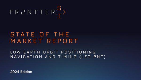
PNT services are integral to industries worldwide, from logistics and telecommunications to critical infrastructure. The rise of LEO satellites is set to revolutionize this space, overcoming limitations of traditional GNSS, such as vulnerability to interference and limited urban coverage, according to FrontierSI.
Key insights from the report, which is the first in a series of annual reports, include:
Industry impacts: How LEO PNT addresses GNSS vulnerabilities, offering more robust and accurate navigation solutions.
Government and regulatory challenges: The rise of commercial PNT players necessitates collaboration to address interoperability, spectrum management and governance issues.
Business innovation opportunities: Critical sectors such as logistics and autonomous systems stand to benefit from assured and precise PNT services.
Investment potential: The nascent stage of the LEO PNT market presents opportunities for investors to identify game-changing technologies and key players.
The report is recommended for professionals and organizations deeply engaged in satellite navigation, including:
Engineers, designers and project managers in the space and defense industries
Autonomous systems manufacturers
Policymakers and regulatory bodies responsible for satellite navigation and spectrum management
Commercial stakeholders in telecommunications, transport and logistics
Academics, researchers and analysts with an interest in satellite navigation technologies
Investors analyzing the growth potential of LEO PNT solutions
Providers of critical infrastructure reliant on precise timing synchronization
The LEO PNT State of the Market Report aims to provide stakeholders with the necessary insights to navigate this transformative period for PNT.
ANELLO Photonics has received a Phase I Small Business Innovation Research (SBIR) contract from the U.S. Navy. The six-month contract will allow ANELLO to demonstrate its optical gyroscope and sensor fusion technologies for navigation without relying on GPS.
Under the contract, the U.S. Navy will evaluate ANELLO’s integrated photonics technology and AI-based sensor fusion engine. These technologies aim to maintain accurate navigation in challenging environments where GPS signals may be unavailable or compromised.
ANELLO Photonics’ technology can be used for construction, agriculture, transportation, robotics, unmanned vehicles and national security. The company’s focus on navigation solutions for GPS-challenged scenarios aligns with growing needs in both military and civilian domains for reliable positioning systems in diverse environments.
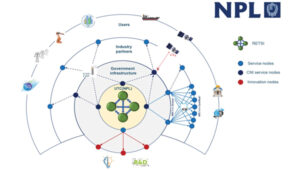
Saying the government must focus on “delivering an operational resilient positioning, navigation and timing (PNT) system for the United Kingdom as soon as we can,” the British Science Minister, Lord Patrick Vallance, announced several initiatives in his opening remarks to the Royal Institute of Navigation’s UK PNT Leadership Seminar on Nov. 20, 2024.
Among them was a funding increase for the National Physical Laboratory’s National Time Centre (NTC) project from £30 million ($38 million) to £62.7 million ($79 million) and a plan to have NTC and the first of the nation’s new eLoran towers at initial operating capability (IOC) by January of 2027.
Plans for all efforts beyond next year were necessarily “subject to spending review.”
Still, seminar attendees were gratified to hear the minister’s endorsement of the 10-point PNT policy framework published by the previous administration in 2023 and his commitment to operationalizing it with implemented systems.
Shabana Haque, Ph.D., head of the United Kingdom’s National PNT Office, also addressed the seminar and elaborated on the government’s actions to date and plans moving forward. She also discussed efforts toward developing quantum technologies and how all the capabilities would be incorporated into a coherent architecture.
Photo: RNT Foundation
Clocks
The United Kingdom recognizes time and timing as the most fundamental component of the PNT utility. Its NTC R&D program, run by the National Physical Laboratory (NPL), has been up and running since 2019. Its primary objective is to create “…a resilient UK national time infrastructure through the building and linking of a new atomic clock network distributed geographically in secure locations.”
Five years later, that program is coming to an end. Plans are in the works for the next phase of the NTC program, which includes developing a national timing infrastructure and supporting a new timing ecosystem — one that includes two-way satellite-time transfer (TWSTT), eLoran and the country’s legacy MSF radio time service. The industry will have a valuable role in the architecture of time distribution and providing value-added services while accessing highly resilient and well-authenticated core government time infrastructure.
As a result of NTC work to date, traceable time and frequency signals can now be accessed by industry and academia from three NPL nodes dispersed across the United Kingdom. They are at the University of Strathclyde in Scotland, the University of Cranfield in the Midlands and the University of Surrey in the south.
eLoran
eLoran also features prominently in the United Kingdom’s PNT plans. Britain operated Loran-C as part of the Northern European network until the end of 2015. For the last year of that, differential stations were deployed along the United Kingdom’s eastern coast and maritime operations based on eLoran were authorized.
On Jan. 1, 2015, and despite British pleas to the contrary, other northern European nations terminated Loran broadcasts in favor of Galileo. The United Kingdom has continued to operate its single eLoran transmitter as a national time signal. Plans call for additional transmitters to enable eLoran navigation across the nation and its adjacent waters within the next two years.
UrsaNav Loran monitor on Nautel equipment. (Photo: RNT Foundation)
The UK government has been working with several partners to advance its understanding and plan for the implementation of an eLoran capability. Haque highlighted work with the European Space Agency’s NAVISP program, resulting in the British company Roke developing an eLoran antenna for handheld devices.
She also discussed integrating the NTC’s clock and fiber network with eLoran signals and developing GNSS/eLoran receivers.
Many were particularly interested in an “eLoran Effectiveness Report” that the government commissioned and received from the General Lighthouse Authority’s Research and Development (GRAD) team. GRAD has extensive experience with the technology, having operated and evaluated the differential eLoran system along Great Britain’s east coast.
In a related move that helped signal the United Kingdom’s commitment to the technology, the Ministry of Defence issued a Request for Information (RFI) in September 2024 about a deployable eLoran capability. The RFI indicated that the document was a prelude to an acquisition.
Quantum research
The United Kingdom has invested more than £1 billion ($1.3 billion) into quantum research, which has the potential to contribute to PNT with better timekeeping and inertial and gravimetric sensing.
One aim of the quantum research program is to develop “…new navigation and timing systems to provide resilience and improved accuracy in the event of the denial of satellite systems.” A specific goal is to deploy quantum navigation systems, including clocks, on aircraft by 2030.
The program began in 2014 and has seen a significant increase in 2024 with the establishment of five quantum hubs nationwide. The hub at the University of Glasgow focuses on resilient PNT systems for national security and critical national infrastructure.
Policy and coordination
Minister Vallance and Haque also discussed two important non-technology themes.
The first was that the United Kingdom’s PNT office is fully funded, staffed, and very active. It was created last year as a cross-government effort and includes representation from the Ministry of Defence. In addition to pushing the nation’s PNT efforts forward, the office has been engaged with numerous other governments, including those of the United States, Canada, Australia, New Zealand, Europe, Japan and Korea.
USCG Loran tower circa 1995. (Photo: RNT Foundation)
Second, while the PNT initiatives are necessary for the nation’s resilience and security they will also be a source of economic benefits. This goes beyond enabling the British economy to function during local and potentially widespread GNSS disruption events. As the nation develops the technology stack to support its own resilient PNT architecture, along with enabling and supporting policies, resilient PNT devices and services will become marketable to others.
A sovereign PNT capability that can both stand on its own and cooperate with GNSS is becoming increasingly attractive to many nations. Being able to source such a capability from a respected and trusted ally such as Great Britain could make acquiring and implementing such a system much easier for many.
The UK Science Minister also praised the RIN’s work and publication of a series of tools to help explain PNT and the need for resilience to those outside the community. The tools also will help organizations evaluate their readiness for GNSS disruptions.
Available from the RIN’s Resilient PNT Portal, they are
A PNT explainer that outlines risks from over-dependence on GNSS and provides links to other informative resources.
A best practices “placemat” describing a “Prepare, Act, Recover” framework for PNT disruptions.
A PNT resilience checklist for organizations to use to self-evaluate their risk from GNSS disruptions.
The RIN recommends PNT experts use these tools working with customers, suppliers, and partners and act as a “guiding hand.”
The RIN sees these all as a “phase 1 release.” Feedback on the tools is encouraged and should be sent to [email protected]. The RIN team is eager to know what works and what could be improved, as well as to receive suggestions for other efforts.
As a “learned society,” the RIN has a significant influence on government policy and direction. This was recognized by Lord Vallance, saying, “The Royal Institute has played a really important role in recent years to highlight the PNT opportunity and risk, to provide expertise, and to work with government on solutions.”
The RIN’s director, John Pottle, and RIN Fellows Ramsey Faragher, Guy Buesnel and Andy Proctor were all recognized during the seminar for their contributions to the organization’s resilient PNT efforts.
UK leading the west
While China is in the final stages of establishing a nationwide clock system integrated with eLoran and signals from space, and South Korea is following suit, the United Kingdom seems to be the only Western nation in the process of establishing a coherent and resilient national PNT systems-of-systems architecture.
Some nations have substantial fiber timing networks, Europe seems to be on the path to a timing backbone, and the United States has three eLoran transmitters on air. However, none have announced the type of integrated plans the UK has published.
When asked about this, one UK PNT technology and policy expert opined that his nation is so far ahead of Europe and the United States because “we are unencumbered by having our own GNSS.”
His idea is that GNSS involves a lot of time, effort and money. The kind of financial and emotional commitments needed for these huge projects makes it hard for many to come to grips with the limitations and vulnerabilities of GNSS and the need to implement complementary systems. Both government officials and GNSS industry lobbyists may tend to resist such efforts, he said.
Concerning the UK government’s investment in OneNav, he said it is still possible that the United Kingdom might also pursue a space-based capability. Rather than establishing the capability on its own, in his opinion, the government will be much more likely to look for a commercial subscription service.
“We will access GNSS when we can trust it, and may pay for other signals from space,” he said. “But we want a sovereign capability for the United Kingdom, and the future of resilient PNT is terrestrial.”