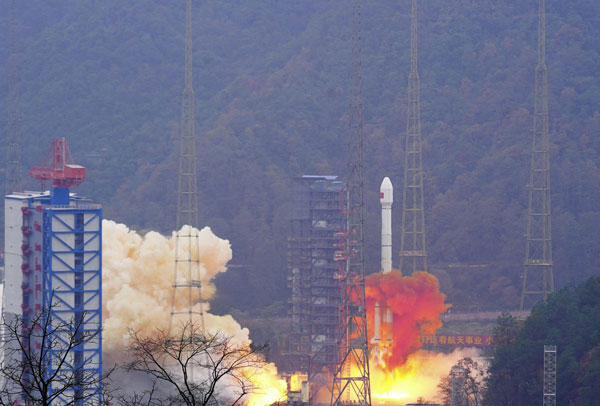
China has launched two satellites into medium-Earth orbits (MEO) for its BeiDou Navigation Satellite System, reported the China Satellite Navigation Office.
The satellites were carried by a Long March 3B rocket from the Xichang Satellite Launch Center in Sichuan province and are the 13th group of third-generation BeiDou satellites operating in MEO.
The two spacecraft will start formal operation after a period of in-orbit technical verification, according to the China Satellite Navigation Office.
BeiDou is China’s largest civilian satellite system and one of four global navigation networks, along with the United States GPS, Russia’s GLONASS and the European Union’s Galileo.
Since 2000, a total of 62 BeiDou satellites, including the first four experimental ones, have been lifted on 46 Long March 3 series rockets from Xichang.
In June 2020, the final satellite to complete Beidou’s third-generation network was lifted by a Long March 3B rocket launched from the Xichang center. The following month, the system was declared complete and began providing full-scale global services.
Nearly 50 Beidou satellites in active service, including the latest pair.
It may be hard to remember — or imagine — life without the Global Positioning System (GPS). From finding the nearest Dunkin’ Donuts to making ATM withdrawals, GPS is part of everyday life. It makes global finance possible, first responders faster, electric grids smarter and industries more efficient. Without GPS, the critical infrastructure that powers homes and workspaces, mobilizes roads and rails, guides air travel, delivers news and even produces food could come to a grinding halt. That fact is not lost on the United States’ adversaries.
Modernizing GPS to make it work better in times of peace and to ensure its resilience in times of conflict is a prime responsibility of the Space Systems Command (SSC) of the U.S. Space Force (USSF).
History
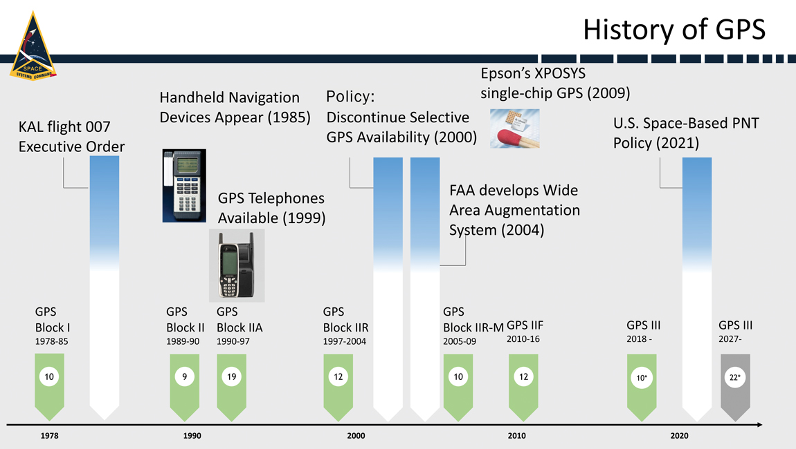
When it comes to anniversaries, 2023 is a big year for GPS. It’s widely considered to be the 50-year anniversary of GPS because it was on December 17, 1973, that the Defense Systems Acquisition Review Council (DSARC) gave U.S. Air Force Col. Bradford Parkinson, now retired and hailed as the father of GPS by many in the aeronautics and astronautics sectors, approval to proceed with development of what would become today’s 31-satellite GPS constellation.
It also marks 40 years since President Ronald Reagan authorized the use of GPS for civil aviation following the downing of Korean Air Lines Flight 007, after it inadvertently entered hostile air space. This year is also GPS’s 30-year anniversary of initial operating capability and the 20-year anniversary of the Federal Aviation Administration (FAA) Wide Area Augmentation System (WAAS), which enhances the accuracy and integrity of GPS services across the entire National Airspace System.
At the most recent meeting of the Civil GPS Service Interface Committee, the recognized worldwide forum for effective interaction between civil GPS users and GPS authorities, Parkinson — who, after his service in the U.S. Air Force earned a Ph.D. and has been a professor at Stanford University for decades — recounted his first-hand experience making GPS a reality. The former chief architect for GPS, who led original advocacy for the system as an Air Force colonel, described the incredible challenges and numerous unique innovations involved in starting this program.
Today’s GPS continues to deliver on its commitments for accuracy, integrity, availability, continuity and coverage. It is considered by many the gold standard in navigation and timing. Yet challenges remain, posed by an increasingly contested space domain and emerging threats from pacing challengers and adversarial nations. Advancing, maintaining and modernizing the GPS enterprise for the benefit of commercial, civil and military users falls under the responsibility of SSC and is carried out by the field command’s Military Communications and Positioning, Navigation & Timing program executive office (SSC/MilComm & PNT), in collaboration with its exceptional mission partners, and launch services provided by SSC’s Assured Access to Space program executive office.
As we celebrate the multiple GPS anniversaries, it is worth exploring successes in GPS modernization. This update will explore the exciting advancements in the GPS space systems, user equipment, and control systems.
Space Systems
On January 18, the Lockheed Martin GPS III Space Vehicle 6 (SV06) launched into orbit aboard the SpaceX Falcon 9 Block 5 rocket out of Cape Canaveral, Florida. The successful launch of SV06 and handoff to the USSF’s Space Operations Command/Space Delta 8/2nd Space Operations Squadron marked another key step in the larger goal of modernizing the GPS constellation. SV06 is the sixth GPS III satellite to be launched and is equipped with the full suite of modernized signals and capabilities. The GPS III satellites are more capable and resilient than their predecessors. Improvements include three times greater accuracy and up to eight times improved anti-jamming capabilities.
In preparation for future launches, the GPS III team has been diligently working with the Assured Access to Space Launch Enterprise to ensure rigorous and successful integration of the GPS III spacecraft’s launch systems onto a brand-new rocket, the United Launch Alliance Vulcan Launch Vehicle. GPS III SV07/Vulcan is targeted for launch in the summer of 2024.
Additionally, production of the tenth and final space vehicle in the GPS III fleet was finalized this year and it has a target launch date of 2026. GPS III Space Vehicles 7-10 are in storage and available for launch, awaiting launch call-up.
The modernization, however, doesn’t end there. GPS IIIF continued to make progress this year with development and integration of the follow-on spacecraft program with 10 vehicles now in production. GPS IIIF Non-Flight Satellite Testbed completed panel integration and initial system performance testing and the program completed an integrated baseline review. The GPS IIIF team worked with the National Security Agency to successfully complete an information assurance preliminary design review, one of the first such reviews of its kind. The team has also made essential inputs to the planning for the future GPS IIIF launch and checkout capability.
GPS III Space Vehicle 06 (SV06) was launched Jan. 18 from Cape Canaveral Space Force Station in Florida. It is the 18th GPS satellite to broadcast the L5 signal.
User Equipment
SSC/MilComm & PNT actively manages and maintains the public GPS interface specifications that allow industry to build civil receivers that successfully capture and process the GPS signal-in-space satellite-broadcast. Simultaneously, SSC also leads design and development of military receivers, currently the Military GPS User Equipment (MGUE). In April, the MGUE Increment 1 team successfully completed technical requirements verification on its MGUE GPS receiver application module — a standard electronic module specifically designed for aviation and maritime users. This allowed the MGUE Inc 1 program to deliver its new aviation and maritime software to the U.S. Air Force and U.S. Navy to support the lead platform integration and testing on the B-2 Spirit bomber and the Arleigh Burke guided-missile destroyer. This is the first fully functional GPS aviation and maritime software suite to support the jam-resistant military M-code signal.
GPS has an active and successful foreign military sales (FMS) program with 60 allied partners, and many of them are highly engaged with SSC/MilComm & PNT to acquire MGUE receivers with their M-code capabilities. According to the Department of State, U.S. allies and partners purchase approximately $45 billion annually in arms, equipment, and training — many equipped with GPS — via FMS.
This spring, the MGUE Increment 2 team, developing an advanced, follow-on receiver, completed the new Next Generation Application-Specific Integrated Circuit (ASIC), the first of two major Critical Design Reviews (CDRs) with mission partner BAE Systems. That success was followed by a second CDR this summer for the MGUE Increment 2 Miniature Serial Interface (MSI) receiver card, which integrates the Next Generation ASIC along with a host of other innovations. L3Harris, a mission partner, has also successfully completed its own next generation ASIC CDR and is on-track for an MSI CDR in October. MGUE Increment 2 also awarded a Joint Modernized Handheld contract to the Technology Advancement Group, enabling this industry partner to move forward on its MGUE Increment 2 Handheld initiative.
Control Systems
While the current operational control system continues performing at a high level, a major update to the GPS modernization architecture is underway. In March 2022, the USSF began formal testing of the Next Generation Operational Control System (OCX) Block 1/2 system through the Functional Qualification Test designed to test OCX requirements. Currently, preparations are underway to follow that up with a major government-led Integrated Systems Test.
OCX developmental testing is an important part of the software development process. Thorough developmental testing can help ensure that OCX is of high quality and meets all requirements. Testing is rigorous and comprehensive; it is a complex and challenging undertaking, but one necessary to ensure OCX is ready for operational use before it is transitioned into service. SSC’s program office is taking the necessary steps to ensure that it will be a success.
The OCX 3F program also contributes to SSC’s advancements in GPS control systems. The follow-on to OCX for support to GPS IIIF spacecraft has successfully completed a Critical Capability Release for the GPS IIIF launch and checkout capability.
GPS IIF
Sustainment
SSC/MilComm & PNT’s GPS Support Delta has a legacy of providing sustainment expertise for Space Operations Command’s operations team. It sustains a global network including a Master Control Station (MCS), Alternate MCS, 11 command-and-control antennas, and 16 monitoring sites, plus 38 on-orbit GPS spacecraft. The sustainment team performs seamlessly, anticipating issues, collaborating with operators, updating servers and software tools, enhancing cyber secutiry and fine-tuning GPS to keep it running at peak performance.
Future Opportunities
In 2019, the department of the Air Force designated the Navigation Technology Satellite-3 (NTS-3) as a Vanguard program and the Department of Defense’s first experimental integrated navigation satellite system in nearly 50 years. Co-sponsored by SSC and the Air Force Research Laboratory, NTS-3 is helping to pave the way for more robust and resilient positioning, navigation, and timing.
In June, SSC/MilComm & PNT hosted its first Alternate/Augmented PNT Reverse Industry Day at SSC’s new Commercial Space Marketplace for Innovation and Collaboration Center. The event was a unique opportunity for government leaders and technical experts to hear directly from industry in a one-on-one environment about their many exciting innovations and opportunities as well as challenges. SSC was joined by its close government and interagency partners, including representatives from the Department of Transportation, the National Space-Based PNT Coordination Office, the Space Operations Command/Mission Area Team, the Air Force Research Laboratory, and the Space Development Agency. Through the event, SSC gained market intelligence and made many valuable industry connections for future investments.
Conclusion
As the nation celebrates an exciting 50-year anniversary of GPS, continued enhancements in the three elements of the GPS enterprise — space systems, user equipment, and control systems — represent significant milestones toward GPS modernization. This essential upgrade is delivering many new GPS capabilities — including robust new signals such as M-code, L2C, L5, and L1C — while preserving backward compatibility for GPS legacy signal users. GPS modernization will enhance utility, make the system more robust and resilient, and ensure that the United States, its allies, and its government agency partners have access to the most accurate and reliable navigation and timing services available. At the same time, while we continue to look for ways to (in the words of the National Space-Based PNT Advisory Board) “protect, toughen, and augment” GPS capabilities, we are also actively engaged in evaluating ways to incorporate alternate sources of PNT, as well as GPS augmentation, that will continue to make PNT capabilities even more robust and resilient in the future.
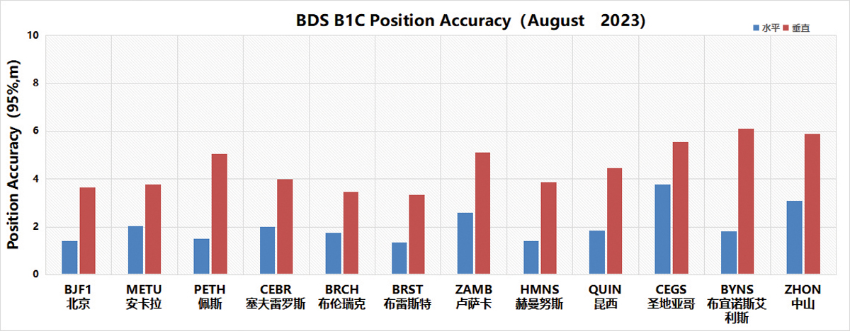
Figure 1. Global position accuracy of the BDS B1C signal (95%) Chart: Test and Assessment Research Center of China Satellite Navigation Office
Over the past year, the BeiDou Navigation Satellite System (BDS) has been continuously striving for world-class excellence throughout its development, especially in the system operation and the development of applications and new technologies. With this relentless innovation and pursuit of excellence, BDS continues to surpass its benchmarks.
System Operation and Services
The establishment of an on-orbit support system and the enhancement of on-orbit operational controls, combined with in-orbit software reengineering and real-time ground diagnostics, have significantly improved BDS’s functionality and service performance. Both space and ground segment operational statuses are regularly evaluated within the engineering framework. Various data sets and schemes are rigorously tested and reviewed to ensure the utmost level of user satisfaction.
In addition, the system integrates new techniques, such as joint satellite-to-ground and inter-satellite control, unified information transmission and coordinated processing of observation data. Combined with artificial intelligence, cloud platforms and big data analytics, the continuous global monitoring and assessment capability for BDS/GNSS has been upgraded.
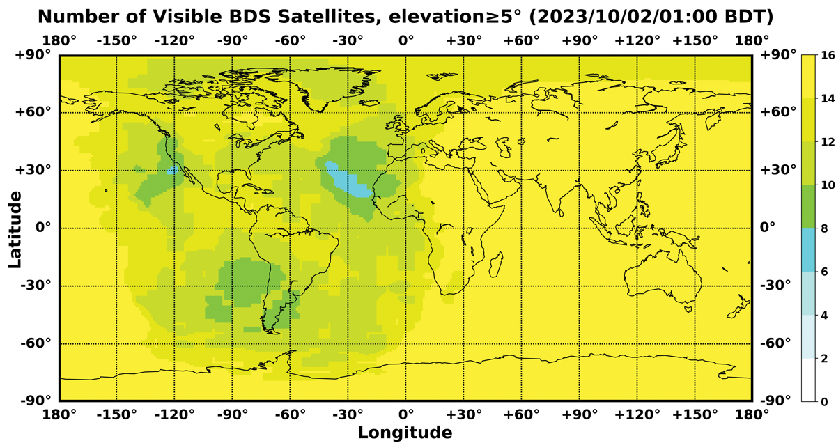
In May, the first BDS-3 GEO backup satellite was successfully launched. Currently, BDS operates a total of 46 satellites in orbit, comprising 15 in the BDS-2 constellation and 31 in the BDS-3 constellation. Since its official commissioning, BDS has been consistently providing reliable services with steadily improving performance metrics. Data from the International GNSS Monitoring and Assessment System (iGMAS) in 2023 indicate that the BDS space signal availability is 100%, signal continuity is 99.996%, and the global positioning accuracy is 5 m, with notable enhancement observed specifically within the Asia-Pacific region. Figure 1 shows the positioning accuracy of the BDS B1C signal assessed with global monitoring stations. Figure 2 shows the number of visible BDS satellites, with a minimum of six to eight satellites consistently in view globally.
BDS remains committed to serving the global community and benefiting humanity by promoting innovations that seamlessly integrate the fundamental positioning, navigation, and timing functions of the system, while building four major service platforms to support the development of BDS distinctive service applications. The International Search and Rescue Service Platform provides MEO search and rescue services that comply with COSPAS-SARSAT standards and offer BDS-based characteristic return link services. The satellite-based augmentation system (SBAS) service platform provides the single-frequency augmentation service using the B1C signal in accordance with APV-I requirements as well as the dual-frequency augmentation service using the B2a signal in accordance with CAT-I requirements. The short message service platform achieves seamless integration with terrestrial mobile communication systems and the Internet, marking a breakthrough in enabling smartphones to connect directly to satellites and bringing regional short message communication services to mainstream smartphone users. The ground-based augmentation service platform has a nationwide network of ground stations and provides high-precision positioning augmentation services in real time, with accuracy levels ranging from meters, to decimeters, to centimeters and even to millimeters for post-processing, to meet the needs of various industries and the general public.
System Applications and Industrialization
Xie Jun
The BDS application industry has experienced sustained growth. In 2022, China’s satellite navigation and location-based service industry reached a total output value of RMB 500.7 billion (approximately $71.5 billion USD). A complete industrial chain has been established, including chips, modules, antennas, boards, receivers and comprehensive services.
The basic BDS products have been continuously developed and have reached a production scale of hundreds of millions. In 2022, the sales of in-car navigation devices in China exceeded 12 million units. Sales of various receivers, including those for IoT, wearables, vehicles and high-precision equipment, exceeded 100 million units. Intensive research and development efforts are underway to integrate BDS navigation capability with inertial, mobile communication and visual navigation methods to enhance the user experience in various application scenarios.
BDS is extensively used in a wide range of sectors and is proving to be a key technological driver of socio-economic growth. In the transport sector, more than 7.9 million road vehicles, more than 40,000 postal and express delivery vehicles, more than 47,000 ships, more than 13,000 aids to navigation on waterways and nearly 500 general-purpose aircraft use BDS.
In agriculture, forestry, livestock and fisheries, more than 100,000 autonomous agricultural machine units, more than 20,000 intelligent livestock tracking collars and more than 100,000 fishing vessels are equipped with BDS receivers. In the water resource management area, the BDS Short Message Service supports hydrological monitoring of more than 2,500 reservoirs. In digital construction, the synergy of BDS with multi-sensor and Internet technologies has proven essential for projects such as the Chengdu-Kunming Railway, the Shenzhen Mawan Undersea Tunnel and the Xinjiang Desert Highway, significantly improving construction quality and efficiency while reducing labor and material costs.
Significant progress has been made in consumer applications. In 2022, 260 million of the newly registered smartphones in China supported BDS, accounting for 98.5% of the total. The BDS short message service has been seamlessly integrated into mainstream smartphones, eliminating the need to change SIM cards, phone numbers or add external devices. Consumers can now access BDS-3’s short message services. BDS-based lane-level navigation has been piloted in eight cities in China, with nationwide deployment planned. BDS-enabled features such as “Dynamic Traffic Light Countdown” and “Traffic Light Status” have covered millions of traffic signals in China, with daily signal queries exceeding 1.4 billion. Moreover, prominent domestic on-line mapping service providers deliver BDS satellite positioning service hits more than 300 billion times daily.
Figure 2. Number of visible BDS satellites Chart: Test and Assessment Research Center of China Satellite Navigation Office
International Cooperation and Exchange
China has strengthened bilateral partnerships to expand cooperation initiatives. In March 2023, the China-Russia Satellite Navigation Major Strategic Cooperation Project Committee was upgraded to the China-Russia Satellite Navigation Cooperation Subcommittee, which held its inaugural meeting in October. The fourth China-Arab States BDS Cooperation Forum was successfully convened in October. Active participation in international events under multilateral organizations such as the United Nations and academic exchanges in the field of satellite navigation have promoted joint discussions on global satellite navigation, ensuring the compatibility and interoperability of navigation satellite systems worldwide.
China has promoted the integration of BDS into international standards set by sectors including civil aviation, maritime, mobile communication, as well as search and rescue. In November 2022, the BDS Short Message Service System became the third global satellite communication system for maritime distress and safety, as recognized by the International Maritime Organization (IMO). In June 2022, the technical standards for BDS B2a and B3I signals were approved by 3GPP, leading to the formal release of BDS-assisted positioning standards for fourth- and fifth-generation mobile communication systems. In November 2022, China officially became a space segment provider for COSPAS-SARSAT.
Intensive efforts have been made to create an enabling “soft environment” through policymaking, standardization and IPR protection to maintain open communication and sustainable development. With the release of “The BeiDou Satellite Navigation Standard System (version 2.0)” in 2022, China has submitted more than 7,000 patent applications related to satellite navigation, underscoring its commitment to innovation and high-quality development. In November 2022, the Information Office of the State Council of China released a white paper entitled “China’s BeiDou Navigation Satellite System in the New Era,” which captures BDS’ transformative journey: unveiling new service capabilities, driving industrial growth, promoting collaborative initiatives and charting future paths.
In April, the 13th China Satellite Navigation Conference was successfully held under the theme “Digital Economy —Intelligent Navigation.” For the first time, challenges related to satellite navigation and positioning, navigation and timing (PNT) systems were solicited and later published on the official BDS website. These challenges cover current and emerging GNSS technologies, services and applications, including the establishment and maintenance of GNSS satellite-based spatial-temporal reference services, the provision of high-precision navigation and timing services in lunar space, the provision of accurate positioning services in complex environments, and the deployment of intelligent applications. In addition, proposals were made to develop a unified theory of multi-source heterogeneous spatial-temporal information for PNT applications, aiming to further integrate BDS, PNT and other new information technologies.
Prospects of Future Development
In the future, two to four backup satellites are scheduled to be launched to strengthen the robustness and accessibility of the BDS constellation. Commitments have also been made to continuously raise the standards of intelligent BDS ground operations and maintenance to ensure stable operation and performance improvement. In addition, system management and routine assessments will be strengthened, with a comprehensive strategy for both space- and ground-based operations to optimize the operational ecosystem and enrich BDS services and user experience.
In the area of emerging technologies, research on improving navigation with low-Earth orbit technologies, as well as its practical applications, will be further promoted to strengthen the precision and integrity of the system and to meet the requirements of an era characterized by ubiquitous connectivity and intelligent devices. Efforts will also include studies on multi-layer space constellations and the fundamentals of lunar space navigation to extend the coverage of BDS services. In addition, research will continue on satellite-based autonomous timekeeping technologies and pulse star technologies, with the aim of establishing and maintaining GNSS satellite-based spatial-temporal reference systems.
With the fundamental philosophy of “independent innovation, open integration, unity of all, and pursuit of excellence” in mind, the integration of BDS with innovative realms such as 5G, artificial intelligence, and big data will be accelerated steadfastly, aiming to shape a national PNT system that’s more ubiquitous, integrated, and intelligent by 2035.
The vast cosmic arena beckons for collaborative exploration. BDS will remain anchored to its mission. BDS is developed by China, dedicated to the world and strives to be first class. With a resolute ambition to promote progress, BDS strives to make significant contributions to the development of human society and a community with a shared future for mankind.
GLONASS remains a core of Russia’s positioning, navigation and timing (PNT) system and is utilized by people around the world. Annual shipments of new GLONASS/GNSS receivers for the communications, transport, agriculture and power industries exceed 25 million units in Russia alone. These users are interested in continuously increasing the quality of PNT primarily based on the improvement of the basic service radio navigation field generated by the GLONASS space complex.
This space complex consists of the constellation comprising medium-Earth orbit (MEO) satellites, the modernized ground control complex and the ensemble of user equipment. The current constellation consists of 26 satellites comprising three generations and five modifications. For the past 15 years, GLONASS-M has been the core satellite and now the constellation includes 21 of them. The fact that 14 of them successfully function beyond their guaranteed active lifetime verifies their high reliability. They are steadily being replaced with GLONASS-K satellites, of which there are already four in the constellation. Along with GLONASS-K launches, the in-orbit testing of the first GLONASS-K2 satellite was initiated on August 7, 2023.
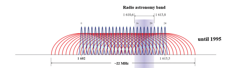
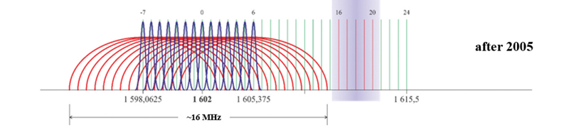
Since the launch of the first GLONASS satellite, the navigation signals have changed significantly. Initially, each of 24 GLONASS satellites transmitted the signals with its own separate carrier frequencies in the L1 and L2 bands (Figure 1). The total bandwidth of the registered GLONASS satellite network was 23.72 MHz in L1 band and 20.72 MHz in L2 band, respectively.
Figure 2. First phase GLONASS FDMA signals spectrum transformation in L1 band. Image: Sergey KarutinFigure 3. Second phase GLONASS FDMA signals spectrum transformation in L1 band. Image: Sergey KarutinFigure 4. Final GLONASS FDMA signals spectrum in L1 band. Image: Sergey Karutin
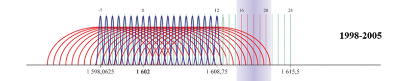
In 1995, the Russian Federation assumed obligations to protect the band used in radio astronomy in the search for extraterrestrial life. At the first stage (until 1998), the broadcast of the navigation signals in the carrier frequency channels 16-20 was terminated and the frequency channels 13, 14, 20 and 21 were used under exceptional circumstances (Figure 2). Then, all newly launched satellites transmitted the signals only in the frequency channels 0-12. By 2005, the total bandwidth of GLONASS satellites was reduced to 16.97 MHz in L1 band and 15.47 MHz in L2 band respectively (Figure 3).
Starting in 2005, GLONASS satellites have been using the frequency channels from -7 to +6 (Figure 4) to broadcast frequency division multiple access (FDMA) navigation signals. As a result, the upper limit of the GLONASS signal bandwidth in the L1 band dropped from 1620.61 to 1610.485 MHz and the lower limit went down from 1596.89 to 1592.953 MHz. The signal bandwidth in L2 band changed similarly.
The GLONASS-K2 satellite was developed to improve GLONASS user performance. The satellite broadcasts new code division multiple access (CDMA) signals in the above mentioned bands as well as in the L3 band. The first satellite of this batch was successfully deployed in orbit on August 7, and already started to broadcast the new CDMA signals. The radio telescope of Bauman Moscow State Technical University is used to monitor the broadcast signals to analyze the frequency and power characteristics of the satellite.
The radio telescope has a large-aperture fully rotatable antenna with a dish diameter of 7.75 m. It ensures that the width of the main lobe of the antenna’s pattern in 1.6 GHz band is 1.8° and the power amplification of the received navigation signals is 40 dB.
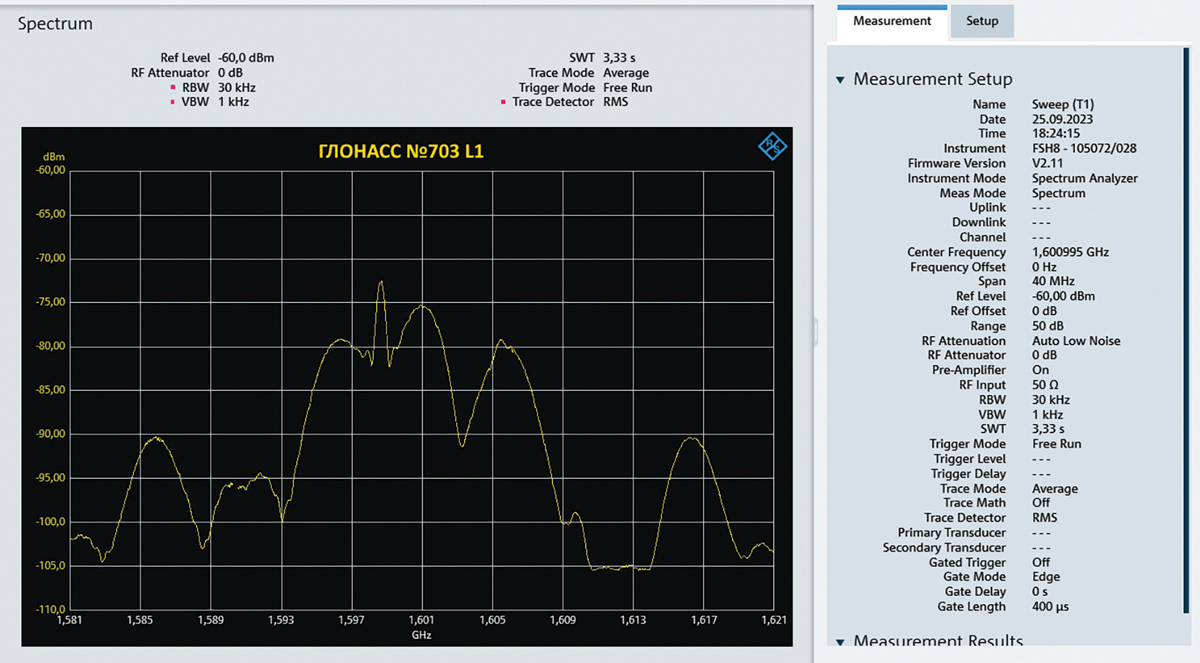
Primarily, users are interested in the new CDMA navigation signal on L1OC transmitted along with the conventional signal on L1OF. The joint group bandwidth of the FDMA signals with the carrier frequency 1598.625 MHz, which refers to the frequency channel -6, and the CDMA signals with the carrier frequency 1600.995 MHz is shown in Figure 5.
The exploitation experience of recently manufactured satellites in practice demonstrates that their operational capacity exceeds their planned lifetime by one and a half times. The final GLONASS-M satellite (No. 761) launched in the last year was manufactured in 2015. These circumstances make it possible to predict that the renewal of the whole constellation with new GLONASS-K2 satellites broadcasting the full ensemble of CDMA signals is likely to be finished by 2035.
In 2024, the renewal of the constellation will continue due to the launches of GLONASS-K satellites and another GLONASS-K2 satellite.
Figure 5. FDMA and CDMA signals spectrum in L1 band, broadcasted by first Glonass-K2 satellite. Chart: Bauman Moscow State Technical University
With the launch of the first GLONASS-K2 satellite accomplished, the Passive Quantum-Optical System (PQOS) is implemented on the base of Russian quantum-optical systems with a wavelength of approximately 0.5 nm. The PQOS ensures pseudorange measurements in the optical band. The elements of the system include specialized ground equipment to register moments of laser pulse emission by a ground laser station (ground PQOS) and specialized satellite payload equipment to register moments of the laser pulse reception onboard (onboard PQOS). Therefore, all GLONASS new generation satellites are capable of performing both conventional active (two-way) measurements and passive (one-way) measurements with the accuracy of timescale difference definition better than a nanosecond and based on the data of laser optical systems.
The processing of active and passive measurements gives an opportunity to get their difference combinations to compare timescales kept by onboard and ground frequency standards at a previously unachievable picosecond level of precision. The accuracy of PQOS results is sufficient to provide in-orbit tests of prospective new generation onboard frequency standards with a daily stability σ around 5×10-15.
The achieved accuracy level of PQOS results is also sufficient to calibrate measurement links for prospective GLONASS satellites, including links of active measurement systems, inter-satellite links and ionosphere-free linear measurement combinations conducted by passive measurement equipment based on FDMA and CDMA signals. The obtained results correspond to the world accuracy level in metrology and ensure the uniformity of measurements. The developed PQOS and technologies based on its measurements fully contribute to the effective metrological support for the tests and operation of the GLONASS space complex, including prospective GLONASS-K2 satellites and the ground complex.
Dana Goward, President of the Resilient Navigation and Timing Foundation, introducing Brad Parkinson and Matteo Luccio, GPS World EIC. (Image: RNTF)
On December 5, in Houston, Texas, at a gala event to celebrate the 50th anniversary of GPS hosted by the Resilient Navigation and Timing Foundation, Matteo Luccio, Editor-in-Chief of GPS World, interviewed Brad Parkinson.
Here are two excerpts from the interview:
How does GPS today differ from the design that came out of the Lonely Halls meeting 50 years ago this past September?
Well, I’m very proud of what happened because, to my knowledge, there is no fundamental difference. Basically, that fundamental design has held up. … As a matter of fact, I still have one of the old Trimble handhelds, it’s called an EnsignGPS. It was one of those little devices that got shipped to the Iraq War. The other day, I pulled it out, batteries were kind of crummy, I got those squared away and went out, sure enough and navigated. I probably hadn’t pulled it out in at least 20 years. The point of the story is that evidently it still works.
What do you consider the most significant impact of GPS on society?
Well, the most significant impact is also probably the most perilous: kids today just take it for granted. They know where they are.
SpaceX’s Falcon Heavy rocket begins its roll out to the historic Launch Complex (LC)-39A at NASA’s Kennedy Space Center in Florida. (Image: SpaceX)
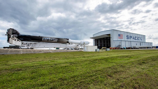
Space Systems Command (SSC) and SpaceX are preparing to launch the U.S. Space Force (USSF)-52 mission into orbit. The Falcon Heavy mission is set to launch on Dec. 10, 2023, from the historic Launch Complex (LC)-39A at NASA’s John F. Kennedy Space Center in Florida.
USSF-52 is the seventh mission of the X-37B Orbital Test Vehicle, an experimental program with technologies designed to provide the U.S. Space Force with a reliable, reusable, unmanned space test platform.
This launch adds to a notable year. The last NSSL Falcon Heavy launched in early January; that mission, USSF-67, was followed by a Falcon 9 launching a GPS satellite 61 hours later, both from the Eastern Range and using the same Space Systems Command crew. The Assured Access to Space team worked alongside SpaceX to complete both launches.
In preparation for a challenging and busy launch schedule, the U.S. Space Force is placing greater importance on being agile and resilient. The ability to conduct launch operations at a faster pace will be particularly crucial for successfully deploying multiple constellations, the Space Force said.
As part of our celebration of the 50th anniversary of the Global Positioning System, three long-time players in the industry share their “GPS origin story,” recent breakthroughs, and their view on the next 50 years of positioning, navigation and timing (PNT). All three began their involvement with GPS between the late 1970s and the late 1980s, before the system was completed. All three are continuously making GPS more resilient and resistant to jamming and spoofing or augmenting it with layered multi-orbit architectures of complementary PNT.
Read the origin stories, recent breakthroughs, and more insights from the following companies:
BAE Systems has more than 45 years of military GPS experience. In fact, the first ever GPS signal reception on Earth happened at one of our offices in Cedar Rapids, Iowa, on July 19, 1977, when one of our legacy companies received the signal. Since that historic day, BAE Systems’ engineers have introduced more than 50 GPS products, including GPS anti-jam and precision landing systems.
As a pioneer in military GPS technology, BAE Systems has delivered nearly two million GPS devices on more than 280 platforms around the world. We design and produce advanced GPS technology compatible with the next generation M-code signal, improving security and anti-jamming capabilities for critical defense applications.
Can you share any recent innovations from BAE Systems?
BAE Systems innovates a full portfolio of M-code-compatible military GPS solutions to meet warfighters’ needs. Our Strategic Anti-jam Beamforming Receiver — M-code (SABR-M) is the most capable integrated anti-jam (AJ) electronics GPS receiver and the first integrated AJ M-code receiver available for weapons systems. It delivers assured, global position, velocity, altitude and timing, as well as strong protection against GPS signal jamming and spoofing — critical capabilities for unmanned aerial vehicles (UAVs), precision-guided munitions (PGMs), and missiles in threat environments.
This past June, at the Joint Navigation Conference in San Diego, BAE Systems unveiled NavGuide, a next-generation Assured Positioning, Navigation and Timing (A-PNT) device featuring M-code GPS technology. It is our response to strong defense market demand for a cost-effective, high performance handheld GPS upgrade. NavGuide provides an intuitive user interface and integrates easily into platforms currently using BAE Systems’ Defense Advanced GPS Receiver (DAGR).
How is your company preparing for the next 50 years of PNT with GPS and beyond?
BAE Systems is making advancements in our critical navigation capabilities for the warfighter through the Military GPS User Equipment (MGUE) Increment 2 program. We are developing a Next-Generation Application Specific Integrated Circuit (NG ASIC) for our small form factor Miniature Serial Interface (MSI) receiver. This will enhance our full portfolio of ground, airborne and weapons M-code assured GPS receivers beyond 2030.
We have invested an enormous amount of time and energy into our facilities and simulator capabilities, especially in our state-of-the-art simulators powered by Spirent Federal signal generation and RF wavefront technology. We want to be prepared to meet the technical demands of an ever-changing threat environment, and we need to be certain our receivers are prepared for the fight the first time, every time. We put our receivers through the paces by running them through thousands of trials on our Spirent simulators to validate and verify our performance under the most demanding scenarios.
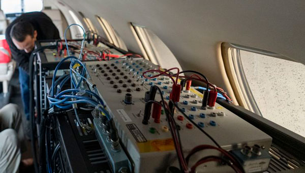
A flight test of Northrop Grumman’s airborne navigation solution, embedded GPS/INS modernization, EGI-M (Image: Northrop Grumman)
What was Northrop Grumman’s GPS Origin Story?
Northrop Grumman’s involvement with GPS has its origins during the mid-1980s, when we became an early adopter. We applied our prior decades of technical expertise in defense and commercial navigation solutions to recognize the significance of GPS as an emerging technology to optimize our inertial navigation products. The first GPS receiver was integrated with the LN-33, our main product for military aircraft, in 1987.
Around the same time, our engineers began to develop an indigenous civil GPS receiver to complement our inertial navigator for use in commercial airliners. This resulted in the certification and fielding of the LTN-2001 product, an eight channel C/A Code GPS receiver. This receiver, in concert with our Autonomous Integrity Monitored Extrapolation (AIME) algorithm, provided our customers a first-ever sole means navigation system using GPS/inertial for non-precision approach.
By the early 1990s, advancements in the semiconductor industry facilitated the reduction of the GPS receiver from a 1,000 cu in stand-alone box to a roughly 6-in by 6-in circuit card. This critical milestone allowed GPS to be embedded into an inertial navigation system (INS) without a significant increase in its size or power consumption and thereby the ubiquitous Embedded GPS INS (EGI) was born. Our first inertial navigation system with embedded military GPS capability was the LN-100G in 1991. This standard form factor was produced across the industry with installations on virtually all the front-line tactical aircraft and rotorcraft for the U.S. Department of Defense (DOD) and many of our allies.
Can you share a breakthrough?
Inspired by accomplishments in the survey community, our team conducted early location accuracy experiments to demonstrate a few decimeters of accuracy between our Woodland Hills, California, location and a facility in San Jose, California, about 500 km away. Leveraging this experience and the same signal processing, our teams became a broader solution provider for adjacent mission applications including precise formation flying for in-flight automated refueling, precision approach and landing, and decimeter-level positioning for the intelligence, surveillance and reconnaissance (ISR) community.
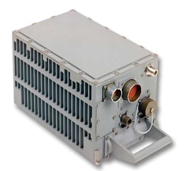
LN-100G. (Image: Northrop Grumman)
In parallel with these developments, Northrop Grumman, in partnership with the Defense Advanced Research Projects Agency (DARPA), improved the resilience of embedded GPS receivers with a more intimate coupling of INS and GPS. The DARPA GPS Guidance Package (GGP) program demonstrated a Navigation Grade Fiber Optic Gyro (FOG), greatly improved GPS tracking performance under extreme vehicle dynamics, and the ability to track at lower signal-to-noise levels. Our success on this program reinforced our reputation as a GPS integration leader and led to the introduction of Northrop Grumman’s current LN-251 product line, which is broadly used in tactical military aircraft.
In the early 2000s, Northrop Grumman initiated research into the feasibility of a Global Navigation Satellite System (GNSS) software-defined radio and started development of what we now call SERGEANT (Software Enabled Reconfigurable GNSS Embedded Architecture for Navigation and Timing). The company used Spirent signal simulators to evaluate proper GPS M-code tracking over a wide range of test cases in a controlled laboratory environment. Together with the Air Force Research Laboratory (AFRL), Northrop Grumman demonstrated advanced receiver capabilities using SERGEANT starting in 2010. In 2018, AFRL used SERGEANT for the first real-time flight demonstration of a GPS M-code SDR.
How is your company preparing for the next 50 years of PNT with GPS and beyond?
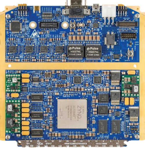
SERGEANT Flight Test SDR. (Image: Northrop Grumman)
Northrop Grumman foresees the world of GNSS being dramatically influenced by the emergence of alternative radio navigation sources as augmentations to traditional GNSS constellations to provide additional robustness and resilience. Our PNT SDR technology is a foundational tool to integrate these emerging radio navigation signals quickly and accelerate deployment to our customers.
Northrop Grumman has led medium-Earth orbit (MEO) and low-Earth orbit (LEO) PNT technology studies through the DARPA Blackjack proliferated LEO (pLEO) program, starting in 2017. Northrop Grumman’s SERGEANT SDR transceiver is currently being integrated for use in emerging pLEO constellations. We anticipate that these capabilities, as well as emerging cooperative radio navigation signals, will become a critical part of the next 50 years of PNT with GPS.
A Spirent user employs a portable GSS6450 attached to an antenna to record GPS, other GNSS, and complementary signals for resilient PNT testing. (Image: Spirent)
What is Spirent’s GPS origin story?
Spirent’s GPS genesis began on a rooftop in the middle of the night in the early 1980s. Engineers were attempting to acquire the new GPS signals with their receivers, scheduling their lives around the times when satellites would pass overhead, angling antennas off a roof in the dark, and hoping for favorable conditions. Those difficulties inspired an idea: since real-world conditions are never the same twice, simulating the signals in a lab would control variables and provide repeatable and trustworthy results.
That idea grew to be Spirent’s positioning division — a team of experts whose sole focus is to partner with customers to accelerate the deployment of robust PNT technology. In 1985, one of the first groundbreaking simulators provided to a customer generated six GPS L1/L2 signals. Soon after, we developed the world’s first simulator with SA-A/S capability, establishing our reputation for innovation. Today, simulation is for much more than convenience. The further upstream testing starts, the better for R&D and investment decisions. Because of that, we work across the spectrum in close partnership with constellation developers, receiver manufacturers, and OEM application integrators.
Can you share a recent breakthrough?
GPS regional military protection (RMP) is a nascent anti-jamming capability that uses a steerable, narrow-beam M-code signal, allowing U.S. and allied forces to operate much closer to interference without losing connection. Spirent supports RMP, so modernized GPS user equipment (MGUE) can be tested and integrated with RMP long before live-sky signals are available.
Another major breakthrough is in AltNav, a catch-all term that includes non-GNSS sources of RF and other complementary PNT, with recent attention focused on low-Earth orbit (LEO) constellations. Spirent has developed LEO AltNav simulators for both the military and commercial sectors that seamlessly integrate with Spirent’s extensive testbed for GNSS, threat simulation, inertial navigation systems, and additional complementary PNT.
How is your company preparing for the next 50 years of PNT with GPS and beyond?
As a trusted industry test partner, one of Spirent’s guiding principles over the past five decades has been to support PNT developers and early adopters by being first-to-market with new signals and constellations. Enabled by our flexible solutions, our dedication to that tenet will continue across the next five decades.
NAVWAR resilience testing is an area where emerging test needs will continue to demand more from the test environment. Layered PNT positioning engines — including GNSS, secure military signals, CRPA systems, multi-orbit architectures, and sensor fusion — are driving complexity in the test regimes that support them. Spirent’s purpose-built solutions are designed to meet these advancements, with deterministic simulation that delivers definitive validation and accurate test results.
Spirent pioneered the use of software-defined radios for GNSS simulation with the GSS9000, which enabled the same architecture to support new signal types, higher motion rates, user-defined waveforms, and more than double the generated signals. The next generation will extend that flexibility, capacity, and ease of integration to future complementary PNT sources while maintaining system performance across physical and virtual realms.
The Educational Irish Research Satellite, EIRSAT-1, has successfully launched from Vandenberg Space Force Base, California, on Dec. 1, 2023. Hitching a ride on a SpaceX Falcon 9 launcher, the small satellite has made history as Ireland’s first satellite.
Over the course of six years, EIRSAT-1 was designed, built and tested by students from University College Dublin (UCD) in Dublin, Ireland, participating in the European Space Agency (ESA) Academy’s Fly Your Satellite Program. The program is a hands-on initiative that helps university student teams develop their own satellites according to professional standards. The launch opportunity itself was provided by the ESA.
Throughout the development of the satellite, ESA experts provided training and guidance to dozens of UCD students, the ESA said. The students’ learning journey included test campaigns at ESA Education’s CubeSat Support Facility in Belgium, as well as dedicated spacecraft communications sessions at both ESA Academy’s Training and Learning Centre and the European Space Operations Centre in Darmstadt, Germany. These sessions were designed to teach the procedures for operating Ireland’s first spacecraft.
From low-Earth-orbit (LEO), EIRSAT-1 will carry out three main experiments, which were built from scratch by the students:
GMOD, a detector to study gamma ray bursts, which are the most luminous explosions in the universe and occur when a massive star dies or two stars collide.
EMOD, an experiment to see how a thermal treatment protects the surface of a satellite when in space.
WBC, an experiment to test a new method of using Earth’s magnetic field to change a satellite’s orientation in space.
Following EIRSAT-1’s deployment to orbit, the student team is now working to establish contact with the satellite and start operations from their dedicated ground control facility, also entirely operated by students and located at UCD in Dublin.
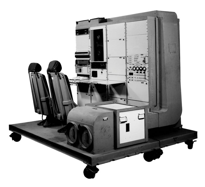
1976: The first military GPS five-channel receiver built in one of several programs that studied the feasibility of GPS. The receiver weighed more than 270 pounds and had seats for two operators. (Image: Rockwell Collins/Smithsonian)
Half a century ago, on December 22, 1973, Deputy Secretary of Defense William P. Clements, on the recommendation of the Defense Systems Acquisition and Review Council, directed the entire Department of Defense — through the Navstar GPS Joint Program Office, under the spectacular leadership of Col. Bradford Parkinson — to proceed with the GPS program. While this magazine mostly focuses on the present and the future, we occasionally pause to remember how it all began.
In the following articles, we are lucky to benefit from the long memories of four gentlemen who were there. Read the full articles.