Category: GNSS

  • Authoritative reference: Projecting GNSS trends through EUSPA’s first market report

    Authoritative reference: Projecting GNSS trends through EUSPA’s first market report

    The European Union Agency for the Space Programme (EUSPA) has released its first EO and GNSS Market Report, where EO stands for Earth observation. The report is the result of a collaboration between 15 EUSPA experts from various fields and market research companies supporting EUSPA, backed by more than 50 external experts who helped validate the market trends and the data. In his foreword to the report, Rodrigo da Costa, EUSPA’s executive director, wrote: “Since its inception, the report has established itself as the most authoritative reference document for information on the global GNSS market. It is regularly referenced by policymakers and business leaders around the world.”

    EUSPA’s EO and GNSS Market Report combines market and application data into one report that provides global coverage of EO and GNSS applications across 17 different market segments: agriculture; aviation and UAVs; biodiversity, ecoystems and natural capital; climate services; consumer solutions, tourism and health; emergency management and humanitarian aid; energy and raw materials; environmental monitoring; fisheries and aquaculture; forestry; infrastructure; insurance and finance; maritime and inland waterways; rail; road and automotive; space; urban development and cultural heritage.

    GNSS receiver shipments will grow continuously in the next decade, from 1.8 bn units in 2021 to 2.5 bn units by 2031. (All images courtesy of EUSPA)
    GNSS receiver shipments will grow continuously in the next decade, from 1.8 bn units in 2021 to 2.5 bn units by 2031. (All images courtesy of EUSPA)

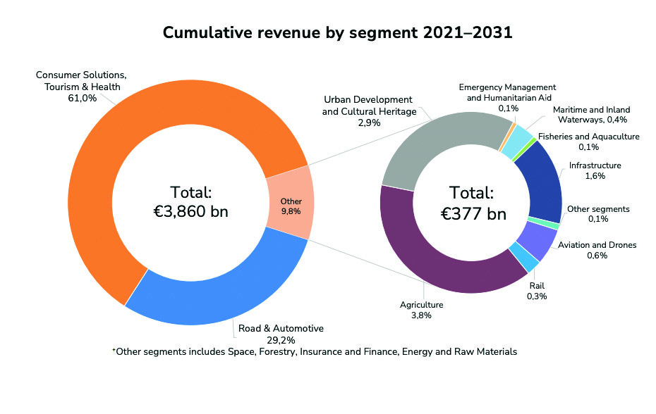
    Growth dominated by consumer solutions

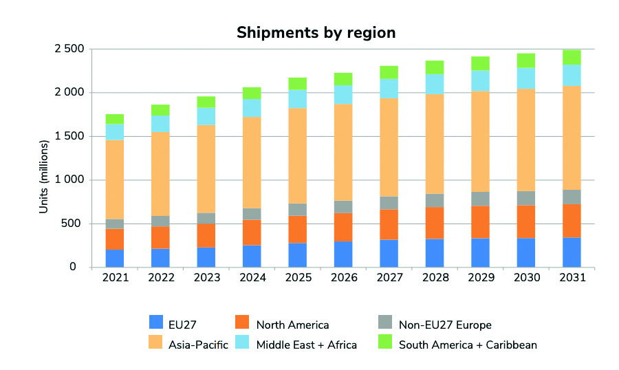
    Between 2021 to 2031, yearly shipments of GNSS receivers are projected to grow from 1.8 billion units to 2.5 billion units. The shipments will be dominated by the consumer solutions, tourism and health segments as the global sales of smartphones and wearables continues to increase.

    The overall installed base will increase from 6.5 bn units in 2021 to 10.6 bn units by 2031.
    The overall installed base will increase from 6.5 bn units in 2021 to 10.6 bn units by 2031.

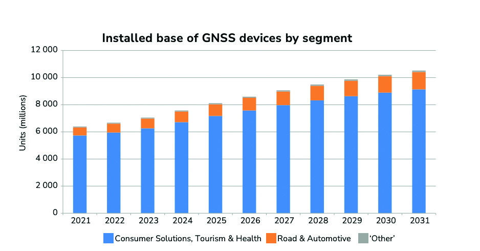
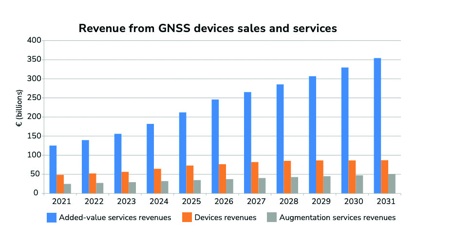
    The global installed base of GNSS devices in use is expected to reach more than 10 billion units by 2031 — dominated by consumer solutions, tourism and health, and road and automotive market segments, which will contribute to 98% of all devices in use. The global GNSS downstream market revenues, which covers both device sales and service-related revenues, is expected to grow at a CAGR of 9.2% over the next decade, reaching €492 billion by 2031. More than 82% of the revenue will be generated by value-added services. Beyond the mass markets, the markets of agriculture, urban development and cultural heritage, and infrastructure will be the main contributors to the global GNSS revenue stream.

    The Asia-Pacific region continues to be at the top of the GNSS revenue market both for device sales and service revenues based on demand. The region is expected to increase its share of the global services revenues, nearing 46% by 2031; however, it will see a decline of its market share of device revenues. The Asia-Pacific region will be challenged by the upcoming markets of South America and the Caribbean, Non-EU27 Europe, the Middle East, and African regions.
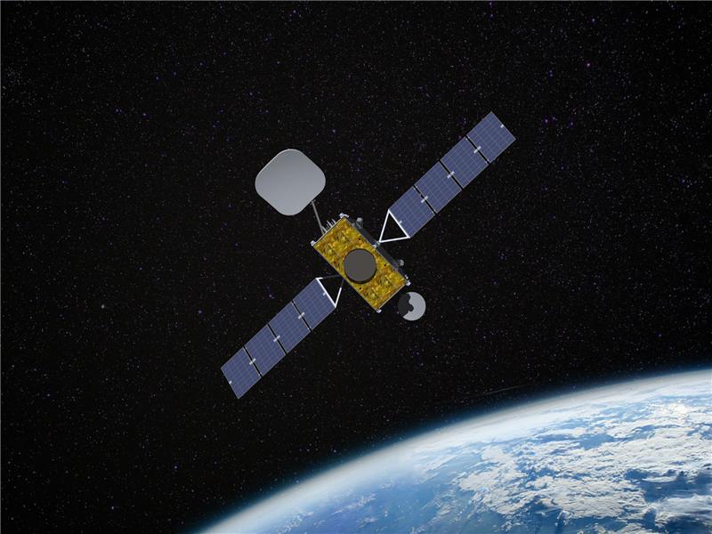
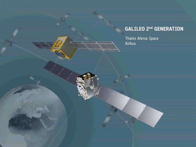
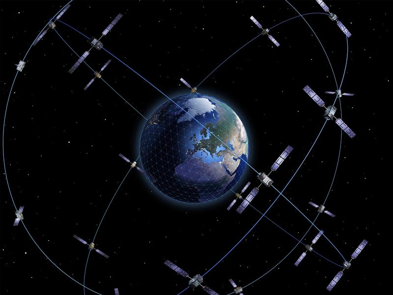
    The GNSS market

    The report defines the GNSS market as activities in which GNSS-based positioning, navigation and/or timing is a significant enabler for functionality. The GNSS market is comprised of device revenues, revenues derived from augmentation and added-value services attributable to GNSS.

    The aviation and UAV market is expected to have significant growth, increasing from 42 m units in 2021 to 49 m units by 2031.
    The aviation and UAV market is expected to have significant growth, increasing from 42 m units in 2021 to 49 m units by 2031.
    The global GNSS downstream market revenues from both device sales and services will grow from €199 bn in 2021 to €492 bn by 2031 with a CAGR of 9.2%. This growth is mainly generated through the revenues from added-value services.
    The global GNSS downstream market revenues from both device sales and services will grow from €199 bn in 2021 to €492 bn by 2031 with a CAGR of 9.2%. This growth is mainly generated through the revenues from added-value services.

    Augmentation services include software products, digital maps and GNSS augmentation subscriptions. Added-value service revenues include data downloaded through cellular networks specifically to run location-based applications, the GNSS-attributable revenues of smartphone apps, subscription revenues from fleet management services, and UAV service revenues across a range of industries. For multi-function devices such as smartphones, the revenues include only the value of GNSS-functionality, not the full device price, so, a case-specific correction factor is used.

    About the charts

    Data on the charts presented in the report start from the year 2020 and are estimated, projected and subject to update in the next edition of EUSPA’s Market Report. Historical figures are actual numbers based on reliable sources, per EUSPA. These will change if the number of applications is expanded in future reports.


    Source: EUSPA EO and GNSS Market Report ISSUE 1,
    copyright EU Agency for the Space Programme, 2022

  • Inmarsat to deliver SouthPAN satellite service to Australia and New Zealand

    Inmarsat to deliver SouthPAN satellite service to Australia and New Zealand

    Image: Inmarsat
    Image: Inmarsat

    Inmarsat has partnered with Australia and New Zealand to deliver the Southern Positioning Augmentation Network (SouthPAN), which will provide accurate, reliable, and instant positioning services in the Asian Pacific region. The positioning service will be delivered on one of Inmarsat’s three new I-8 satellites in 2027.

    SouthPAN will improve positioning accuracy to 10 cm for users in the maritime, agriculture and construction industries.

    “SouthPAN represents extraordinary potential for the region,” Todd McDonell, president of Inmarsat Global Government, said. “It can save lives by enabling precision safety tracking, help farmers improve productivity through automated device tracking, or even support transport management systems of the future.”

    The Inmarsat I-8 satellites will also be a critical part of a safety-of-life-certified SouthPAN for aviation and other applications, scheduled for 2028.

  • Galileo second gen enters full development phase

    Galileo second gen enters full development phase

    Image: Galileo_Second_Generation.jpg
    Image: ESA

    On May 31, the European Space Agency (ESA) announced the main procurement batch of Galileo Second Generation (G2), initiated in summer 2022, has been finalized. The system is now ready for its on-orbit validation development phase.

    Following the opening session of the European Navigation Conference (ENC), Javier Benedicto, director of navigation for the ESA, invited Thales Alenia Space, Airbus Defence and Space, and Thales Six GTS  to sign contracts commencing system engineering support for the next generation of Europe’s navigation satellite system.

    Satellite-building contracts were awarded in May 2021 to Thales Alenia Space and Airbus Defence and Space to create two independent families of satellites amounting to 12 G2 satellites in total. Separate contracts were also awarded to Safran Electronics and Defence-Navigation and Timing and Leonardo to provide the ultra-precise atomic clocks carried aboard.

    Employing electric propulsion for the first time, and hosting a higher-strength navigation antenna, the G2 satellites will incorporate six (rather than four) enhanced atomic clocks as well as inter-satellite links to communicate and cross-check with one another. They will be controllable with an increased data rate to and from the ground and will operate for 15 years on orbit.

    In addition, G2’s fully digital payloads are being designed to be easily reconfigured on orbit, enabling them to respond to the evolving needs of users with novel signals and services.

    There are 28 Galileo satellites on orbit, making it the most precise satellite navigation system —providing meter-level accuracy to more than four billion users around the globe. There are 10 Galileo satellites due to be launched, after which the first of the G2 satellites with enhanced capabilities are expected to join the constellation in the next few years.

  • Xona Space Systems certifies Spirent’s SimXona

    Xona Space Systems certifies Spirent’s SimXona

    Image: Spirent Federal Systems
    Image: Spirent Federal Systems

    Xona Space Systems has fully certified Spirent Federal System’s SimXona, a Xona satellite constellation simulator. Spirent will launch SimXona at the ION Joint Navigation Conference, June 12-15, 2023, in San Diego, California.

    SimXona can simulate the Xona low-Earth orbit (LEO) constellation on its own, and in tandem with Spirent’s positioning, navigation, and timing (PNT) and threat simulation capabilities. Spirent has developed LEO simulation solutions for both the military and commercial sectors, including modeling software that combines the simulation of precise LEO orbits and highly accurate GNSS signals — delivering greater realism for applications that have no margin for error.

    Spirent will be accepting orders for SimXona soon.

  • Galileo SAR enhanced with new Greenland site

    Galileo SAR enhanced with new Greenland site

    Image: KimKimsenphot/iStock / Getty Images Plus/Getty Images
    Image: KimKimsenphot/iStock / Getty Images Plus/Getty Images

    The European Union Agency for the Space Programme (EUSPA) and Naviair — a company that specializes in air navigation and related infrastructure services and is owned by the Danish state and represented by the Ministry of Transport — have partnered to strengthen the monitoring capabilities of the Galileo search and rescue (SAR) service by adding a new site in Greenland.

    The partnership between EUSPA and Naviair will expand the ground segment and current SAR capabilities. As part of the agreement, Naviair will contribute to the Galileo Programme objectives by procuring, deploying, hosting, and operating a reference beacon (REFBE) near the Kangerlussuaq Airport in Greenland.

    The new SAR/Galileo site and REFBE will be located around the margins of the declared service coverage area and will be fully integrated into the SAR ground segment, bringing the number of REFBEs to eight. The REFBEs provide data for service performance monitoring.

    There are currently five REFBEs in the European coverage area and two in the Indian Ocean coverage area.

    The REFBEs are fitted with vertical linear polarized antennas that transmit timely, synchronized signals equivalent to a standard 406 MHz Cospas-Sarsat beacon. This, combined with their well-known position, enables specific SAR/Galileo Service performance indicators to be derived.

    The new site will be ready by the fourth quarter of 2023.

    The SAR/Galileo component of the EU Space Programme plays a crucial role in the detection of emergency signals transmitted by distress beacons in support of the internationally recognized SAR Cospas-Sarsat program. As part of this program, the Galileo SAR Service utilizes SAR instruments onboard Galileo satellites, medium-Earth orbit local user terminals, and a network of SAR REFBEs located across Europe.

  • Seen & Heard: Earthquakes and high-speed chases

    Seen & Heard: Earthquakes and high-speed chases

    “Seen & Heard” is a monthly feature of GPS World magazine, traveling the world to capture interesting and unusual news stories involving the GNSS/PNT industry.


    Photo:
    Image: Dennis Laughlin/iStock/Getty Images Plus/Getty Images

    GNSS records Alaska earthquake data 

    Researchers in Alaska were able to compare the quality of GNSS and seismic station data when assessing the magnitude 8.2 Chignik earthquake near Dillingham, Alaska. Research recorded by Revathy Parameswaran and colleagues at the University of Alaska, Fairbanks, shows that GNSS and acceleration seismic data can be used interchangeably or in tandem to estimate rapid magnitude or ground motion. The research showed the Chignik earthquake velocity records were almost identical at co-located GNSS and seismic stations for observations at frequencies of less than 0.25 Hz.


    No more high-speed chases

    Photo:
    Image: Screenshot from CBS New York video

    The Old Westbury Police Department of Long Island, New York, has chosen a high-speed pursuit alternative — GPS-equipped darts that relay the current location of suspects, reported CBS New York. It took $36,000 to equip six patrol cars with the air-powered dart launcher, called StarChase, which can be activated from inside the patrol car. When the launcher is activated, it shoots onto the suspect’s vehicle a dart with a GPS receiver inside and an adhesive exterior. It is considered a safe alternative to high-speed chases and safe to use around pedestrians.


    TikTok CEO says app doesn’t track 

    Photo:
    Image: Marco_Piunti/iStock/Getty Images Plus/Getty Images

    Shou Zi Chew, CEO of the popular app TikTok, testified before Congress that TikTok does not collect precise location data from its users. During the hearing, which lasted for more than five hours, Chew assured committee members the app does not collect nor distribute location data. TikTok is under fire as a bipartisan Senate proposal is aimed at banning the social media app, arguing it poses cybersecurity risks. The House Committee interrogated Chew regarding the app’s algorithmic feed, policies for young users and — given TikTok’s Chinese ownership — the amount of access the Chinese government has to user data.


    Just some water, please 

    Photo:
    Image: Bob Douglas/iStock/Getty Images Plus/Getty Images

    Satellite mapping data analyzed at Graz University of Technology’s Institute of Geodesy has revealed long-term drought conditions in Europe, reported GIM International. The data confirmed groundwater levels have been low consistently since 2018. The drought situation was originally published by Eva Boergens in “Geophysical Research Letters” in 2020 when she noted there was a severe water shortage in Central Europe during the summers of 2018 and 2019. There has been no significant rise in groundwater levels since then, and groundwater levels have stayed constantly low. 

  • EUSPA to hold Galileo HAS Days

    EUSPA to hold Galileo HAS Days

    Image: ESA
    Image: ESA

    On June 28-29, the European Union Agency for the Space Programme (EUSPA) will host Galileo High Accuracy Service (HAS) Days for users, industry stakeholders, application developers and international experts to learn more about HAS. This event provides an opportunity for all attendees to discuss and share expectations of Galileo HAS, its challenges, and benefits.

    Over two days, participants will learn more about the status of Galileo HAS, including current performance, evolution plans and key user applications. There will also be dedicated user sessions, including live demonstrations allowing participants to experiment the Galileo HAS capabilities.

    In addition, participants will visit the European GNSS Service Centre (GSC), the single interface between the Galileo system and the users. The GSC is a center of expertise, knowledge sharing, custom performance assessment, information dissemination and support to the provision of value-added services enabled by the Galileo services.

    The GSC hosts the high accuracy data generator, which computes the HAS orbit and clock corrections as well as the signal biases that are broadcast through the Galileo constellation and over the internet.

    This first edition of the Galileo HAS Days will be held as a hybrid event, so attendees can join either online or physically at the Instituto Nacional de Técnica Aeroespacial (INTA), in Torrejón de Ardoz, Madrid, Spain.

    The draft agenda is available here.

    Registration for the event is open until June 16 for those willing to attend onsite. Click here for more information.

  • New Galileo sensor station operating in South Pacific

    New Galileo sensor station operating in South Pacific

    Photo:
    Image: Screenshot of GSS Map from EUSPA

    The newest addition to the network of Galileo sensor stations (GSS) is up and running in Wallis and Futuna, a French territory in the South Pacific consisting of three main islands and many tiny islets. It enables increased Galileo coverage in the southern hemisphere.

    The European Union Agency for the Space Programme (EUSPA) reported that the decision for the new station was made in June 2020; however, due to COVID-19, its deployment did not begin until summer 2022. In October 2022, the second mission to Wallis and Futana took place to complete the deployment and connect the station to the ground mission segment network for data collection.

    The GSS is a network of antennas deployed at remote locations around the world. They have small, omnidirectional receiving antennas 50 cm high that check the accuracy and signal quality of individual satellites and pinpoint current satellite orbits. Establishing GSS is difficult and requires security accreditation by EUSPA’s Security Accreditation Board.

    To make the best use of the Galileo services, users rely on more than just the satellites. Dedicated facilities such as the Galileo control centers, sensors, and uplink stations are important components that make up the Galileo ground segment — which supports the service provision of Europe’s GNSS. The GSS is an important element of Galileo’s ground segment.

  • China completes multiple satellite launches that include replenishing the BeiDou constellation

    China completes multiple satellite launches that include replenishing the BeiDou constellation

    Photo:
    Image: Nikada/E+/Getty Images

    On May 16, China launched a BeiDou satellite to replenish the constellation, reported Space News. This brings the constellation total to 56 satellites.

    This backup satellite was aboard a Long March 3B rocket, which launched from the Xichang Satellite Launch Center in southwest China at 10:49 p.m. Eastern Time. The satellite aims to improve BeiDou’s stability, positioning precision and overall health.

    In addition to launching the BeiDou satellite, China also launched satellites to study Earth and synthetic aperture radar test satellites (SAR) for disaster prevention.

    On May 21, the Macau Science Satellite 1A and 1B launched on a Long March 2C rocket from the Jiuquan Satellite Launch Center at 4 a.m. Eastern Time. This satellite was designed to study the Earth’s magnetic field.

    Also, on May 21, aboard the same rocket was the Luojia-2 (01), a Ka-band synthetic aperture radar test satellite for Wuhan University. The Luojia-2 (01) will test signal enhancement and integration of remote sensing imaging, meteorological detection and more.

    The China Aerospace Science and Technology Corporation has planned more than 60 launches this year and has already completed 20 thus far.

  • UK considering eLoran broadcast licenses

    UK considering eLoran broadcast licenses

    Photo:

    The United Kingdom’s spectrum agency, Ofcom, is seeking comments on its proposal to issue licenses for broadcasting eLoran signals and services. This initiative comes, it says, after the agency was “…approached with a request to authorize use of the 90-110 kHz spectrum for the provision of a long-range navigation system, based on eLoran technology.” Issuing licenses could be a way to treat all interested parties fairly.

    After briefly describing the importance of positioning, navigation, and timing (PNT) services to modern life, the Ofcom request for comment observes: “Satellite-based PNT systems like the Global Positioning System (GPS) can be susceptible to interference and can be vulnerable to space weather events. The eLoran technology provides a terrestrial-based alternative … which could in [the] future act as a supplementary or back-up system to GPS. [I]t has the potential to support innovation in the delivery of resilient PNT.”

    This rationale is quite similar to that cited by other governments operating Loran-like systems around the world.

    Until now, with a few minor exceptions, only government entities and those working on their behalf have been authorized to use the frequency. Such licenses would authorize holders to broadcast eLoran in the 90 kHz to 110 kHz band, which is the portion of spectrum reserved internationally for radio navigation.

    From October 2014 to December 2015, the UK had an operational eLoran network serving the waters off its east coast and authorized for maritime use. That system was discontinued when France and Norway bowed to pressure from supporters of Europe’s Galileo system, which was still in development. The UK Ministry of Defence still broadcasts a single eLoran signal from Anthorn, UK, that can be used as a wireless timing source.

    Several other nations currently broadcast some version of Loran in the 90 kHz to 110 kHz band. These include PNT systems operated by South Korea, Saudi Arabia, Russia and China. Reports indicate Iran is also broadcasting in the spectrum, though other details remain unclear.

    Unconfirmed reports from amateur radio operators in the United States seem to indicate that testing of Loran-like signals in the 90 kHz to 11 0kHz band has been conducted in North America periodically over the last 10 years.

    Until now, the UK has only formally authorized eLoran and the frequency for maritime use. Observers in the UK say this Ofcom initiative will almost certainly expand that to its use everywhere and for multiple applications, such as timing for critical infrastructure.

    Ofcom says, “[d]eployment of eLoran in the UK could complement existing PNT services, particularly in locations where there is poor GPS coverage or weak signals, like tunnels or deep inside buildings. eLoran could also provide resilience (i.e., back-up) for satellite-based systems against interference, jamming and spoofing, thereby aiding protection of key national infrastructure…”

    This Ofcom notice may be the first official move toward encouraging one or more entirely commercial eLoran services.

    Commercial wide-area PNT services capable of protecting critical infrastructure and national economies have long faced an uphill battle, though.

    Several industry leaders have commented that “it’s impossible to compete with free GNSS!”

    The same leaders have also criticized the U.S. government for not “walking the talk” when it comes to resilient PNT. At a U.S. Department of Transportation meeting last year they urged the government to not just tell others, but to set an example and protect itself with resilient PNT services. Doing so, they said, would show industry and users the government is serious and instill confidence that commercial services were reliable and would be sustained.

    Yet, experts cite a “chicken and egg” problem.

    “The government can’t subscribe to services that don’t exist, and companies can’t stand up and provide nation-wide services without having an anchor-customer first,” according to an industry insider.

    To solve this dilemma, public-private-partnerships have been proposed over the years in both the UK and the United States. To date, a willing “public” or government partner has yet to be identified for either nation.

    This might be changing in the UK government with growing awareness about the limitations of and threats to GNSS and other space systems. While a national strategy for PNT has been promised for years and is yet to be published, a cross-government PNT office has recently been established.

    “The UK is in a great position to lead the world on resilient PNT,” said one observer at a recent Royal Institute of Navigation event. “The key is working with GPS and other GNSS, while at the same time ensuring your nation has its own sovereign system independent of space. We (in the UK) have deep expertise and experience at the GLA (General Lighthouse Authority) with eLoran, and we have a superb tech economy. Britain could be the world’s leading producer of a resilient PNT tech stack that includes eLoran transmitters, receivers that use GNSS, eLoran, and other signals or phenomena, and all the supporting gear and IP (intellectual property) to make it all work.”

    “Realizing that vision will take a bit more government leadership than just issuing a few broadcast licenses, though,” they said.

  • SSC completes final delivery of second payload to Japan for hosting on QZSS

    Space Systems Command (SSC) has successfully delivered the second and final spaceflight-ready payload to Japan, bolstering the contribution by the U.S. Space Force (USSF) to integrated deterrence in the region.

    The two USSF payloads, developed by MIT Lincoln Laboratories, will be hosted on Japan’s GEO-based Quasi-Zenith Satellite System (QZSS). The deliveries of both payloads to Japan follows a Memorandum of Understanding signed between the two nations in December 2020.

    This effort aims to demonstrate the ability of the U.S.-Japan alliance to extend to space; contribute toward the Department of Defense’s broader integrated deterrence posture against shared adversaries in the Indo-Pacific theatre; contribute to the USSF’s Space Domain Awareness; and provide a basis for future opportunities with international partners.

    The hosted payloads will augment the USSF’s ability to conduct persistent, time-dominant volume search at geosynchronous orbit. Launch dates for the host satellites, QZS-6 and QZS-7, have not yet been announced.

  • TRX Systems awarded military contract for PNT device

    TRX Systems awarded military contract for PNT device


    Image: TRX Systems 
    Image: TRX Systems

    TRX Systems has been awarded a $402 million, seven-year contract by the U.S. Army for the procurement of dismounted assured positioning, navigation, and timing system generation II systems and services (DAPS GEN II).

    The TRX Systems solution to be provided under the contract, TRX DAPS II, enables dismounted maneuver operations even where GPS is compromised or denied. TRX DAPS II provides assured positioning, navigation, and timing (PNT) to dismounted users by disseminating assured position and time to dependent devices in GPS-challenged environments.

    TRX DAPS II fuses inputs from M-code GPS, inertial sensors, and complementary PNT sources. It is a small, lightweight PNT device that supports both standalone operation and integration with the Nett Warrior ensemble. It can also distribute PNT information to a customized tactical watch.

    The TRX DAPS II solution employs a modular architecture and adheres to Army PNT interface standards, facilitating the addition of new PNT sensors as threats evolve.

    TRX DAPS II will be in production for the Army later this year.