ION’s Pacific PNT Conference is a global cooperative development of Positioning, Navigation and Timing technology and applications where policy and technical leaders from around the world meet to discuss policy updates, receive program status updates and exchange technical information.
The 2022 conference will be hosted virtually April 11-13 PDT on a complimentary basis for ION members. The conference will include sessions on policy and status updates, performance schedules and plans, plus special challenges affecting Asia-Pacific presented by an elite list of experts representing BeiDou, COSMIC/ FORMOSAT, and QZSS.
A session will broadcast each day at 9:00 a.m. JST / 5:00 p.m. PDT. Live-stream attendees will have the opportunity to participate in virtual question and answer periods through the portal.
Russian military doctrine assumes GLONASS and other GNSS will not be available once a battle begins, so will instead turn to Loran-C for navigation
Russian forces are expert at jamming and spoofing GNSS. As a result, military analysts say, Russian military doctrine assumes that signals from space, including it’s own GLONASS and other GNSS, will not be available once a battle begins.
According to the Russia and CIS Radionavigation Plan, the terrestrial Chayka system, a version of Loran-C, is maintained to protect their homeland with navigation and timing services when signals from space are not available. The portable Skorpion system is designed for military use during expeditions to areas where Chayka or Loran is not available, according to western military analysts.
“Fixed Chayka transmission sites operate between 90 Khz and 110 Khz. Power output is typically between 200 and 800 kW with effective ranges over land of about 800 miles and over water of 1,000 miles,” explained Dana Goward, president of the Resilient Navigation and Timing Foundation. He noted that little information is publicly available about the military Skorpion system.
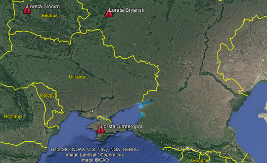
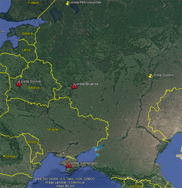
“Three of Russia’s Chayka/Loran stations have Ukraine surrounded,” explained UrsaNav CEO Charles Schue, referring to a graphic he provided GPS World. “They provide ideal coverage and will allow navigation accuracy of between 20 and 50 meters over most of the Ukraine. Upgrading to an eLoran equivalent could give them 5-to-10-meter accuracy, but I am sure the current setup is more than adequate for their purposes at the moment.”
Image: Charles Schue, UrsaNav
Schue was the first commanding officer of the U.S. Coast Guard’s Loran Support Unit and the first program manager for the congressionally mandated Loran Modernization and Recapitalization project that was upgrading the U.S. Loran-C system to eLoran. As CEO of UrsaNav, he is helping several countries with Loran-C and eLoran projects.
One of the three surrounding Loran transmission sites is in the Crimea, which Russia invaded and annexed in 2014.
“The primary reason for taking Crimea may have been ensuring access to the ocean,” Schue said, “but it also allowed them to regain control of the Loran transmission site there. This has assured them sovereign terrestrial PNT [positioning, navigation and timing] for the entire region, including the Black Sea.”
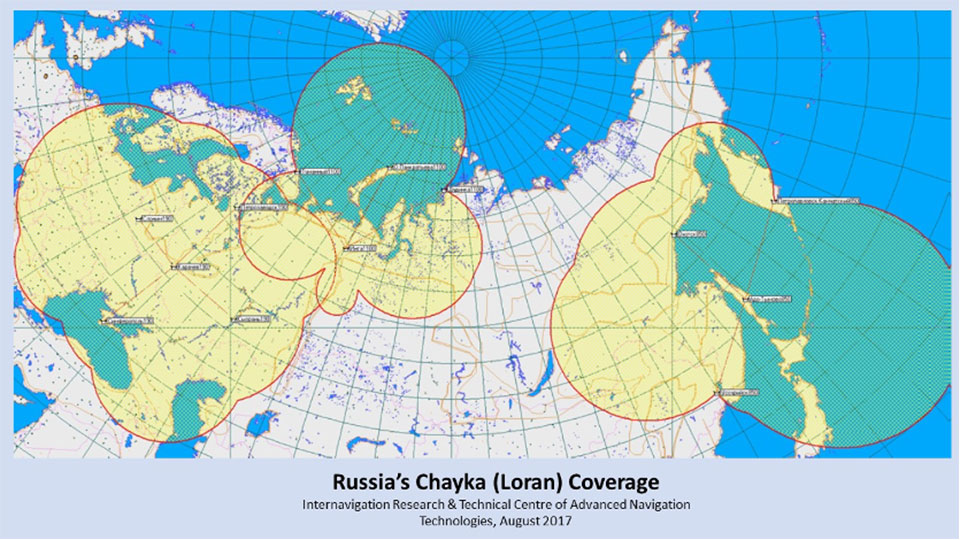
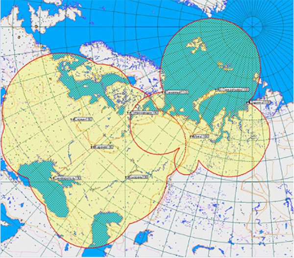
A 2017 coverage map from Russia’s Internavigation Research and Technical Centre of Advanced Navigation shows Chayka serving eastern Europe, western Russia, and almost all of the Black Sea.
Image: Russia’s Internavigation Research and Technical Centre of Advanced NavigationImage: Russia’s Internavigation Research and Technical Centre of Advanced Navigation
The European Space Agency is looking for navigation and positioning ideas, with its Navigation Innovation and Support Programme (NAVISP) seeking input by March 31.
NAVISP is divided into a trio of elements. Element 1’s scope of activities ranges from initial feasibility studies and viability analyses all the way to full proof of concept for promising positioning, navigation and timing (PNT) systems and services.
To compile its annual Element 1 workplan, NAVISP invites innovative PNT concepts from companies or academic entities across NAVISP participating states. Those interested can submit a 1-page description, along with notifying their national ESA delegation of their application. See details here.
NAVISP Industry Days took place in 2020 at at ESA’s ESTEC, The Netherlands. (Photo: ESA)
The NAVISP Element 1 workplan supports cutting-edge European companies in development of novel PNT technologies and services. Underscoring the commercial priority of this field, 20 ESA Member States plus Canada have joined the program.
PNT underpins a 10th of Europe’s economy, according to ESA, in areas such as transport, precision agriculture, power, communication, banking and the fast-growing internet of things.
Satellite navigation, with signals from space extending across the globe, represents the single biggest source of PNT information, but these signals are not available in all locations and are vulnerable to natural or human-made interference.
NAVISP Element 1 is focused on innovation in PNT, involving novel concepts, techniques, technologies and systems along the entire value chain. They often combine GNSS with other solutions such as artificial intelligence, other sensors, adding Wi-Fi or 5G signals to PNT fixes, or employing high-altitude atmospheric platforms to supplement GNSS coverage over regions in need.
Hemisphere GNSS has added to its lineup another Vega heading and positioning OEM board that uses Lyra II and Aquila chipset technology — the Vega 34. The Vega 60 board was previously announced as using the Lyra II and Aquila chipsets.
Hemisphere’s Lyra II and Aquila application-specific integrated circuit (ASIC) designs simultaneously track and process more than 1,100 channels from all GNSS constellations and signals including GPS, GLONASS, Galileo, BeiDou, QZSS, NavIC, SBAS and L-band.
Integrators who use predecessor Hemisphere 34-pin products, such as Crescent Vector H220 and Phantom 34 OEM boards, can easily transition to the improved positioning performance and the superior satellite tracking abilities of the Vega series, the company said.
The Vega 34 board connectors have no circuitry changes and are identical for all Vector users, enabling them to add Atlas H10 and H30 precise point positioning (PPP) into their solutions.
“Vega 34 gives our integrators an easy path forward to enrich their own product offerings,” said Miles Ware, director of marketing at Hemisphere. “For the first time, Crescent Vector integrators can upgrade to multi-frequency without changing pinouts. They can also take advantage of other standard features like more than 1,100 tracking channels, Cygnus interference mitigation technology and spectral analysis.”
NavIC Upgrade. The introduction of the Vega 34 board also brings a new firmware release. Version 6.05 extends several features and improvements and introduces NavIC (IRNSS) tracking and positioning across the entire Vega and Phantom product lines.
Both real-time kinematic and Atlas positioning solutions are enhanced with improved performance in challenging environments. Users of the BeiDou satellite systems and B2b PPP integrators also will see significant advances in their solutions.
ComNav Technology Ltd. is providing GNSS technology to Africa for projects in land mapping, continuously operating reference station (CORS) construction, precision agriculture and other fields, according to a Feb. 11 article in People’s Daily, the largest newspaper in China.
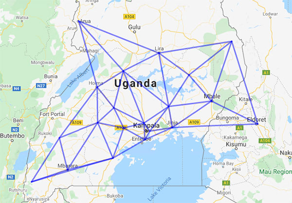
Every day, thousands of users in Africa are using GNSS products, the newspaper stated, highlighting specifically the use of China’s BeiDou satellite navigation system. For instance, CORS using ComNav GNSS/BeiDou receivers have been built in 11 sub-Saharan African countries, including Kenya and Uganda.
Uganda. To meet the demand for high-precision GNSS, the government of Uganda purchased ComNav’s real-time kinematic (RTK) receivers to build its own CORS. Thirty stations have been built so far, creating the most advanced CORS network in East Africa. Its high-precision spatial and temporal information supports land mapping, mining, vehicle management and meteorological monitoring, among other industries.
In 2015, Mulindwa David, chairman of the Uganda Surveying Association, and others visited the Shanghai headquarters of ComNav to learn about its high-precision products and technologies. After training, David and others mastered basic RTK operation and learned simple maintenance.
David used to carry heavy optical equipment every day, but now he only needs to hold a BeiDou receiver to process the relevant data, which has greatly improved his work efficiency and accuracy. “It took at least three days to survey a dozen kilometers of road with optical equipment,” he said. “With BeiDou high-precision receivers, only 10 hours is enough.”
The Uganda CORS network. (Image: ComNav)
Burkina Faso. In response to the COVID-19 outbreak, the Burkina Faso government decided to build a hospital for infectious diseases. In April 2021, it used ComNav GNSS high-precision technology to provide survey data for the hospital’s construction. The land security and topographic surveying tasks were completed in six days, half the time scheduled, said Augustin Bamouni, secretary-general of the country’s national surveying association.
A surveyor in Burkina-Faso surveys the site of a new hospital for infectious diseases. (Photo: ComNav)
Tunisia. The China-Arab BeiDou/GNSS Center is located in the Ghazara Science Park in northern Tunis, the capital of Tunisia. Inaugurated in 2018, it is China’s first overseas BeiDou center, providing satellite navigation training, test evaluation and technical research for African and Arab countries. On average, the center receives real-time data from more than 12 BeiDou satellites at once.
The center will help Tunisia and other African countries train professionals in GNSS technology to support development of the digital economy, according to Amiri Khalil, state secretary in charge of scientific research at Tunisia’s Ministry of Higher Education.
China-Arab BeiDou/GNSS Center is in Tunis, Tunisia. (Photo: ComNav)
China-Africa Forum. The first China-Africa BeiDou System Cooperation Forum was held in November 2021 in Beijing to encourage cooperation between China and Africa and promote use of BeiDou. Four cases from ComNav Technology were described in the forum’s document citing application scenarios of BeiDou in Africa.
ComNav Technology has deepened its cooperation with Africa since China’s Belt and Road Initiative began in 2013. Besides providing products and technologies, ComNav arranged employees to go abroad to provide technical support, traveling to Cameroon, Nigeria, Mali, Zambia, and other African countries. Despite the pandemic, ComNav continues to provide professional service and training both in person and remotely.
“Seen & Heard” is a monthly feature of GPS World magazine, traveling the world to capture interesting and unusual news stories involving the GNSS/PNT industry.
GO, FISH!
Scientists at Ben-Gurion University in Israel discovered goldfish are good drivers. An aquarium on wheels uses lidar, an onboard camera, and motion-detection software to track a fish in the tank. When it swims toward a side of the tank, the vehicle rolls in the same direction. Fish learned to navigate a small area to hit a target for a reward at least 15 times per half-hour, showing their sense of direction isn’t limited to a watery environment.
North Korea’s recent missile tests are being guided by GLONASS rather than BeiDou, claims a source close to the Chinese military. In January, Pyongyang fired at least four short-range ballistic missiles into the sea off the coast of the Korean peninsula. North Korea also tested hypersonic missiles on Jan. 5 and 11. As reported by the South China Morning Post, the source said North Korea has been using GLONASS and has benefited from Soviet technology.
The National Highways Authority of India (NHAI) will start using GNSS/3D automated machine guidance to construct highways. First up: the new Lucknow-Kanpur Expressway. Three machine-control systems will be integrated, guided by a computerized 3D model of the project. NHAI expects the technology to almost double the speed of highway construction, as well as provide stakeholders with mobile updates.
Photo: Tonga Meteorological Services, Government of Tonga
SATELLITES REGISTER OCEAN ERUPTION
While imagery satellites captured the explosive Jan. 15 underwater volcanic eruption in Tonga, GNSS satellites also registered its effects. The energy released reached the ionosphere and was picked up by GNSS signals passing through it (see JPL’s findings). The eruption blanketed Tonga’s main island in ash and devastated its western coastline, affecting up to 80,000 people, according to news reports. It also caused damage to an underwater cable, resulting in a major communication outage. The tsunami that followed reached as far as Japan and the U.S. West Coast, and caused a massive oil spill off of Peru.
The Munich Satellite Navigation Summit program is now online and registration for the event is open. The summit will be held online March 7-8.
The Munich Satellite Navigation Summit focuses on satellite navigation in the present day and future, featuring global speakers and highlighting the latest developments in the field of GNSS. This year’s theme is “AI in GNSS – Intelligence brought to Navigation”.
The summit will feature 12 sessions from industry experts, including sessions on the following topics:
First and Second Generation of the European Satellite Navigation System Galileo
Modernization of the US Global Positioning System
Status and modernization of the Russian Global Satellite Navigation System GLONASS and the Chinese Beidou System (BDS)
Developments of regional systems like the Japanese QZSS and the Indian IRNSS and the Korean Positioning System (KPS)
Use of AI within the navigation world and its implications
The 216-page report is designed to help anyone who seeks to make EU space technologies part of their business plan, develop new space downstream applications, and see a tangible return on investment.
More than ever society relies on innovative solutions to deal with the big data paradigm, respond to and mitigate climate change, natural and man-made disasters, curb the spread of diseases and strengthen a global supply chain that underpins our daily lives.
Download report here.
Earth observation and GNSS data is becoming increasingly important to innovative solutions for climate change, disaster and disease response, and global supply chain management. Dozens of applications are emerging or already in use by citizens, businesses, governments, industry, international organizations, NGOs, and researchers around the world.
The report provides analytical information on the dynamic GNSS and EO markets. In 2021, GNSS and EO downstream markets generated more than €200 billion in revenues and are set to reach almost half a trillion over the next decade.
The report also offers in-depth analyses of global trends and developments through illustrated examples and use cases. Using advanced econometric models, it also offers market evolution forecasts of GNSS shipments or EO revenues spanning to 2031.
Green Investments
EUSPA is committed to helping the EU deliver on the Green Deal agenda and the fight against climate change, starting with embedding space data and services into professional activities. According to EUSPA, accelerating Europe’s engagement in space is pivotal to enabling the green transition and reaching climate neutrality by 2050.
The report emphasises how users of EO and GNSS contribute to compliance, monitoring and efficiency of green investments, benefiting companies, regulators and society as a whole. It focuses on concrete examples across the 17 identified market segments.
For instance, Galileo can provide smart power grids with robust timing and synchronization down to a nanosecond, improving their performance. In another example, EU space plays a role in green energy, as Copernicus helps optimize performance of tidal power generators by providing tidal current prediction systems.
Key Report Findings
Global GNSS- and EO-enabled revenues crossed €200 billion in 2021 and are set to reach almost €500 billion over the next decade.
The global installed base of GNSS devices in use will reach more than 10 billion units in 2031.
The market for Earth observation applications is boosted by a large pool of value-added services (85% of global revenue).
The European EO industry is dominated by SMEs and start-ups; from a supply perspective, European companies hold more than 41% of the global EO market.
The downstream space application market accompanied by the EU Space Programme will continue growing and thereby effectively contributing to European policies (such as the European Green Deal and EU’s Digital Decade), as well as global policies (such as the United Nation’s Sustainable Development Goals and the Paris Agreement) in combination with other technologies.
The U.S. Coast Guard Navigation Center (NAVCEN) will transition to a new and enhanced website in the first quarter of this year. The actual transition date has yet to be determined.
As part of the transition, the URLs will be updated across the site, including URLs linked to PDFs. URLs from the legacy site will no longer work. Any bookmarked URLs or URLs used in automatic downloading of data or products will need to be updated.
“We have identified the below URLs as essential to your continued business,” reports Rick Hamilton, CGSIC Executive Secretariat, in a . “Please keep in mind, that while we are sending the URLs in advance, they will not be active until we launch the new website. Once the new website goes live, your URLs will be available for re-bookmarking.”
A new surveying and mapping textbook is now available on the OPEN Textbook network.
Written in English, the book provides an academic introduction to the field of surveying and mapping. It is based on handouts and readers written for the third-year course “Surveying and Mapping” in the civil engineering bachelor’s program at Delft University of Technology in The Netherlands.
The textbook covers a wide range of measurement techniques, from land surveying using GPS/GNSS and remote sensing to the associated data processing, the underlying coordinate reference systems, and the analysis and visualization of the acquired geospatial information.
Although a few parts of the book are specific to The Netherlands, for the most part the material is applicable globally.
Surveying and Mapping
Authors: Christian Tiberius, Hans van der Marel, René Reudink and Freek van Leijen / Delft University of Technology / The Netherlands
NextNav participated in the European Commission’s Joint Research Centre (JRC) alternative positioning, navigation and timing (APNT) evaluation in Ispra, Italy. At the trial, NextNav showcased an alternative PNT backup to GNSS, TerraPoiNT.
According to the JRC, the trial is analyzing the technologies “which could deliver positioning, and/or timing information, independently from GNSS, to be effective backup in the event of GNSS disruption, and if possible to be able to provide PNT in the environments where GNSS cannot be delivered.”
The test furthers the European Union’s creation of a backup to GNSS and is intended to assess which technologies could strengthen and expand the European PNT capacity.
PNT services are critical for the global economy, with studies estimating a contribution to the European GDP of approximately 10%. Today, GNSS services are the backbone of PNT, with an increasing role in new services and technologies, including car-sharing, autonomous vehicles, ship and aircraft navigation, smart logistics and precision agriculture.
It’s About Time
The timing capabilities of PNT are heavily utilized today by critical infrastructure, which is strategic from a commercial and societal perspective, including telecom, energy, finance and transportation. Published studies estimated economic losses of around 1 billion EUR per day if GNSS were unavailable.
NextNav’s TerraPoiNT trial focused on measuring the precision of timing delivery across alternate timing sources to better understand performance in GNSS-free environments — including instances of outages, spoofing and jamming. As a part of the trial, NextNav also demonstrated its capabilities in providing both indoor and outdoor z-axis vertical location.
TerraPoiNT is a system for assured PNT that uses terrestrial transmitters deployed around a service area to triangulate the location of a device. Unlike national space-based systems, the proximity of NextNav’s transmitters makes the signal strength 100,000 times that of GPS.
“The trials are part of the global trend to develop a resilience layer to space-based GPS/GNSS systems that is more secure and available,” said Ganesh Pattabiraman, NextNav CEO. “We are redefining the capabilities of APNT technologies and look forward to working with the European Commission on furthering these initiatives to build a GNSS backup layer that can deliver highly precise PNT across use-cases.”
Trials for U.S., Europe
The U.S. and countries across Europe continue to invest in both understanding and taking steps towards creating a resilient PNT layer in each nation. Participation in the JRC trial builds upon the recent evaluation of APNT technologies in the United States, including a 2021 U.S. Department of Transportation report, where TerraPoiNT was found to be the best performing APNT solution across use cases.
Further, NextNav recently created an APNT testbed in the San Francisco Bay area that was developed as part of a U.S. Department of Homeland Security demonstration used to evaluate the precision and resilience of NextNav’s TerraPoiNT network.
The JRC is expected to report results from the evaluation this spring.
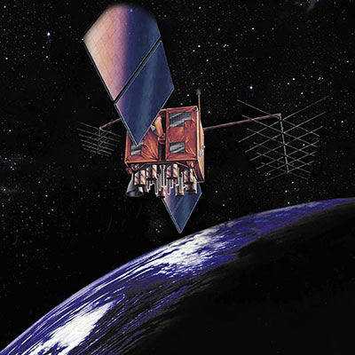
Artist’s rendition of a GPS-IIR satellite in orbit. (Image: GPS.gov)
The U.S. Space Force has announced the decommissioning of GPS satellite SVN-47 (PRN-22), which officially took place Jan. 18. The satellite has been unusable since Dec. 2.
SVN-47 was a replacement satellite in the second generation of GPS satellites (GPS-IIR), launched Dec. 21, 2003.
The announcement was made in a Notice Advisory to NavStar Users (NANU 2022001) issued by NAVCEN, U.S. Coast Guard.
The designation PRN-22 will be used to bring SVN-41 back in to the active constellation. After 2200 Zulu on Jan. 2o, GPS will transition SVN-41 (PRN-22) into the broadcast almanac for all satellites, and SVN-41 will resume transmitting L-band signals. The almanac transition, accomplished one satellite at a time, will require approximately 24 hours to complete.
A second NANU emphasized that “Before, during, and after transition SVN-41 (PRN22) will remain unusable until further notice.”
SVN-41, the sixth of the GPS-IIR satellites, was launched on Nov. 10, 2000, and set to active service a month later on Dec. 10. It was decommissioned in July 2021.