The U.S. Coast Guard has issued a Notice Advisory to Navstar Users (NANU) detailing the changes to the constellation now that the second GPS III satellite has joined.
The U.S. Space Force Second Space Operations Squadron (2 SOPS) issued an Initial Use (USABINIT) NANU for the second of the new generation of GPS-III satellites, designated SVN-75/PRN-18.
SVN-75 was launched on Aug. 22, 2019, and — having successfully undergone rigorous operational testing on orbit — has taken its place in the active GPS constellation with the slot and plane designation of D6.
Constellation changes
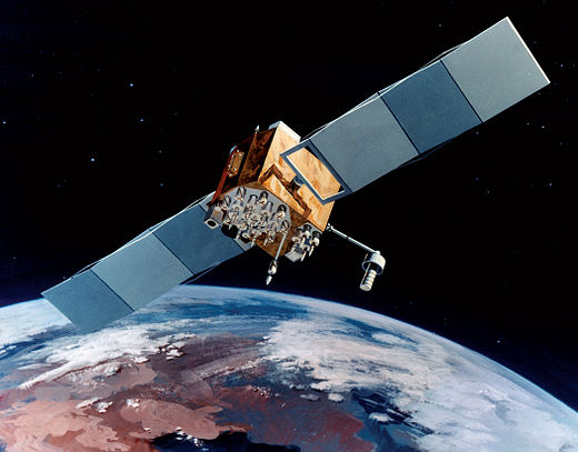
Artist’s rendering of GPS IIF satellite. (Image: U.S. Air Force )
SVN-45/PRN-21 is being re-phased from D3 to D2F replacing SVN46. Upon its arrival, SVN-46/PRN-11 will then be moved to residual status in Launch, Anomaly and Disposal Operations (LADO).
SVN-60/PRN-23 was decommissioned on March 2, eight and a half years beyond its expected service life. SVN-60 was the 12th GPS-IIR to go in to orbit, and began service on July 9, 2004.
The Edge1 system by Skycatch is a combination GNSS base station and drone data-processing unit that delivers high-accuracy maps and point clouds in minutes.
The high-performance built-in Nvidia TX2 Mobile GPU enables both maps and point-cloud processing locally within 30 minutes, as well as running artificial intelligence (AI) tasks in real time.
The base station of the Edge1 uses a Swift Navigation dual-frequency GNSS real-time kinematic (RTK) receiver. The receiver supports signals from GPS, GLONASS, BeiDou and Galileo, enabling reliably fast centimeter-level accuracy globally even in remote locations, with reliable 5-centimeter accuracy.
Users of the Edge1 system can process and receive their maps in the field, without the need for internet connectivity to process data. The system automatically generates 2D maps and 3D data, with the capability to download and use them in Skycatch’s Data Hub, as well as commonly used programs like Civil 3D, BIM360 and others.
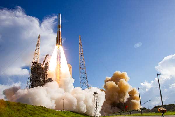
A ULA Delta IV rocket carrying GPS III SV02 lifts off from Space Launch Complex-37 on Aug. 22. (Photo: ULA)
The Space and Missile Systems Center achieved a major GPS milestone on March 27 with the Contingency Operations (COps) program and GPS III Space Vehicle (SV) 02, both of which received U.S. Space Force’s Operational Acceptance approval.
COps is an upgrade to the current GPS Operational Control System to operationally command and control GPS III satellites. These satellites are the newest generation built by Lockheed Martin, providing precise positioning, navigation and timing information with three times better accuracy, and up to eight times improved anti-jamming capability than previous generations of GPS satellites.
The first GPS III satellite, SV01, was launched on Dec. 23, 2018, and achieved Operational Acceptance on Jan. 2, 2020. USSF made SV01 available for use by military and civilian users for critical missions worldwide on Jan. 13.
Operating in a trial period since October 2019, COps supports developmental testing of the GPS III ground and space capabilities. The trial period culminated in a fully mission capable rating from the Air Force Operational Test and Evaluation Center’s Operational Utility Evaluation conducted on the new GPS III satellite and COps upgrade. This event successfully completed on Feb. 20.
Subsequently, GPS Operational Control System and COps received the second GPS III satellite — SV02, nicknamed “Magellan” — which the Space and Missile Systems Center launched on Aug. 22, 2019.
“The COps and GPS III SV02 Operational Acceptance marks another major milestone for the GPS enterprise and presents a clear picture that the Department of Defense is moving to the future,” said Lt. Col. Stephen Toth, 2nd Space Operations Squadron commander. “Of all the programs that will be delivered this year, there are few that carry with it as significant an impact to the warfighter and civilian users as this program will. This is truly a remarkable leap forward for the GPS enterprise and the capability it provides, and I couldn’t be more proud of the team that came together to make it happen.”
Photo: ULAA ULA Delta IV rocket carrying GPS III SV02 lifts off from Space Launch Complex-37 on Aug. 22. (Photo: ULA)
GPS IIIF’s M-code can be broadcast from a high-gain directional antenna in a concentrated, high-powered spot beam, in addition to a wide-angle, full-Earth antenna. (Artist rendering: Lockheed Martin)
U.S. Space Force, Lockheed Martin upgrade Operational Control System (OCS) and refresh GPS constellation with new satellites.
The final steps to fully enable the ultra-secure, jam-resistant military code (M-code) signal on GPS are now underway.
As part of the U.S. military’s effort to modernize GPS, the U.S. Space Force has been steadily upgrading its existing GPS Ground Operational Control System (OCS). The Space Force recently announced Operational Acceptance of the GPS Contingency Operations (COps) upgrade, developed by Lockheed Martin.
The Space Force’s M-Code Early Use (MCEU) upgrade, delivered earlier this year, will enable the OCS to task, upload and monitor M-code within the GPS constellation, as well as support testing and fielding of modernized user equipment, prior to the completion of the next-generation ground control systems.
This spring, work will begin to install the components needed to command and monitor the M-Code encrypted GPS signal, which enhances anti-jamming and protection from spoofing, as well as increases secure access for our forces, into the GPS OCS. M-code signals are available on all the on-orbit GPS IIR-M, IIF and III space vehicles.
A key to enabling M-code is a new software-defined receiver Lockheed Martin developed and is installing at all six Space Force monitoring sites. The M-code Monitor Station Technology Capability (M-MSTIC) uses a commercial, off-the-shelf general purpose graphics processing unit (GPU) to cost effectively receive and monitor M-code signals. Operators can monitor the signal as needed. M-MSTIC complements MSTIC’s, which Lockheed Martin developed and fielded to replace aging hardware receivers that were becoming difficult and expensive to maintain.
“Our warfighters depend on GPS signals every day for many critical missions, so anything we can do to make these signals more resistant to jamming and spoofing is extremely important — and available today,” said Johnathon Caldwell, Lockheed Martin vice president of Navigation Systems. “The more powerful GPS III/IIIF satellites coupled with Lockheed Martin’s upgrades to the GPS ground system are making that possible.”
GPS III also provides a new L1C civil signal, compatible with other international GNSS, such as Europe’s Galileo.
Lockheed Martin is contracted to build up to 32 GPS III/GPS III Follow On (GPS IIIF) satellites to help modernize the GPS constellation with new technology and advanced capabilities. The delivery tempo for these modernized GPS satellites will allow for several launches per year. The third M-code enabled GPS III satellite, named “Columbus,” is expected to launch in April, 2020.
Red Dragon Cybersecurity Suite
Cyber defenses across the upgraded GPS system were recently evaluated by a government assessment team and passed the Operational Utility Evaluation. Lockheed Martin delivered the Red Dragon Cybersecurity Suite (RDCSS) Phase III upgrade during the fourth quarter of 2019, dramatically improving Defensive Cyber Operations (DCO) visibility into GPS network traffic.
Other add-ons include user behavior analytics to analyze patterns of traffic and network taps to improve data collections.
“GPS is an attractive target for our adversaries, so it was critical we bring our best cybersecurity defenses to the table,” said Stacy Kubicek, vice president of Mission Solutions Defense and Security. “Since we began sustaining the Ground OCS in 2013, we have systematically upgraded and replaced software and hardware — it’s now a very secure system.”
Lockheed Martin has sustained the GPS Ground OCS since 2013. In November of 2018, the team completed the AEP 7.5 architectural change – replacing the hardware and software to improve resiliency and cybersecurity. In December of 2018, the Air Force awarded Lockheed martin the GPS Control Segment Sustainment II (GCS II) contract to further modernize and sustain the AEP OCS through 2025.
The GPS III team is led by the Production Corps, Medium Earth Orbit Division, at the Space Force’s Space and Missile Systems Center, at Los Angeles Air Force Base. The GPS OCS sustainment is managed by the Enterprise Corps, GPS Sustainment Division at Peterson Air Force Base. 2 SOPS, at Schriever Air Force Base, manages and operates the GPS constellation for both civil and military users.
The U.S. Space Force’s Space and Missile Systems Center’s GPS Next Generation Operational Control System (OCX) program on March 26 instructed Raytheon to replace the computer hardware in OCX prior to system delivery.
The IBM computer product line used in the system was sold to a Chinese company, Lenovo, in August 2014. At the time of the sale, the U.S. government identified this as a major impact to OCX by creating an unacceptable cyber risk. However, the government waited implement a fix until Raytheon showed promising program performance in delivering OCX.
“Over the last two and a half years, since OCX came out of its Nunn-McCurdy breach, Raytheon has been executing as planned, giving us confidence in OCX’s ability to transition into operations,” said Lt. Gen. John Thompson, SMC commander.
Software development was completed in the fall of 2019, and the program is in the integration and test phase. Within a year, Raytheon is expected to deliver a qualified software baseline capable of operating the GPS constellation, Thompson said.
In 2017, the federal government sponsored a hardware trade study with U.S.-based vendors to replace IBM’s hardware. As a result of the study, Hewlett Packard Enterprise (HPE) was selected as the vendor. The program then conducted a pilot project replacing the IBM hardware in the 17 external monitoring stations and four ground antenna sites, resulting in successful HPE replacement.
“This gave us confidence that we had a viable OCX technical solution providing a long term sustainable hardware baseline that meets our stringent cyber security requirements,” said Lt. Col. Thomas Gabriele, SMC’s OCX materiel leader. “As Raytheon continues to track to their contractual commitments, addressing the unsupportable IBM cyber security risk is prudent to do pre-system delivery to the government.
“Although this government-directed change will impact the Raytheon schedule, the government is holding Raytheon accountable to deliver qualified software prior to integrating on the HPE platform and deploying to operational sites,” Gabriele said.
“By executing the fix now we eliminate $150 million in rework and retesting, and ensuring we deliver a system that is capable of transitioning to operations,” said Barbara Baker, SMC Command and Control Division’s senior materiel leader.
Decades-old hardware
Another benefit of the $378 million government-directed contract change is the opportunity to replace the now decade-old IBM hardware. This will improve system performance and increase the OCX program supportability posture.
“OCX is critical to continuing high priority national efforts to modernize GPS with new military and civil positioning capabilities, including enhanced security, precision, reliability, and integrity. OCX will deliver sustained, reliable GPS capabilities to America’s warfighters, allies, and civil users,” Baker said.
The OCX program is part of the GPS Enterprise Modernization. OCX will deliver two times more satellite capacity, modern cyber-secure infrastructure, improved accuracy, globally deployed modernized receivers with anti-jam capabilities, and improved availability in difficult terrain.
“As a high interest program, we will continue to work with our industry partners to deliver a global GPS capability, Gabriele said.
In response to the ongoing coronavirus pandemic, the test campaign for the first two satellites of Galileo’s Batch 3 has been suspended.
The suspension is based on the medical advice for social distancing — too high a concentration of people is needed on site if testing were to continue, according to the European Space Agency (ESA).
An aerial view of ESTEC. The Erasmus building is at front right. The T building (home to ESA’s Galileo team) is in the foreground. (Photo: ESTEC)
The satellites are based at the ESTEC Test Centre in the Netherlands for engineering tests ahead of launch. The stored satellites are being monitored by staff visiting ESTEC every few days, to verify that all is in order.
Other Galileo-related testing continues with the aim of supporting future launches. ESTEC-based lifetime testing of the next set of rubidium atomic clocks is set to continue, involving on-site monitoring every few days.
Working from home
ESA’s Directorate of Navigation has shifted to teleworking while also ensuring the continuity of essential tasks, in particular the continued delivery of positioning, navigation and timing services of both Galileo and EGNOS.
The ESA team is using video and audio conferences to continue meetings with the industries involved and minimize the impact on the deliveries of EGNOS upgrades, Galileo Batch 3 satellites, and preparatory work for Galileo Second Generation.
The national, local and industrial decisions on travel, meetings and quarantine are impacting the ability to deliver all ongoing commitments, so measures are being taken to minimize their impact, ESA said in a press release.
Priority has been given to ensure continued operations of both EGNOS and Galileo, so the ESA Navigation Directorate has been supporting the European GNSS Agency (GSA), the operator of Galileo and EGNOS, on behalf of the European Commission.
The team also is maintaining constant contact with various stakeholders.
NAVISP and Horizon 2020
Research and development projects under the Directorate’s Navigation Innovation and Support Programme (NAVISP) are continuing at a somewhat slower pace, given the crisis. So are satellite navigation projects financed by the EU’s Horizon 2020 programme, which develop future technology for the EU satellite navigation projects.
“Confronted with this unprecedented situation, our efforts are focussing on business continuity and supporting the GSA with services provision of Galileo and EGNOS, while taking all necessary measures to protect our personnel,” said Paul Verhoef, ESA Director of Navigation. “An impact assessment will only be possible when we see the end of the restrictions in the various European countries. For the time being, stay home, stay healthy, is the priority, whereas however we are in close contact with industry to try and keep momentum on the projects that are underway.”
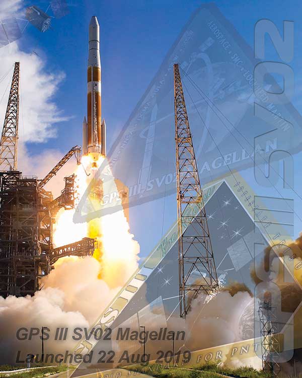
On March 23, the U.S. Space Force’s Space and Missile Systems Center successfully transferred the second GPS III space vehicle (GPS III SV02) to Space Operations Command.
GPS III SV02, dubbed “Magellan” in honor of Ferdinand Magellan, the Portuguese explorer who led the first expedition to circumnavigate the Earth, is now officially under the control of the Second Space Operations Squadron located at Schriever Air Force Base, Colorado.
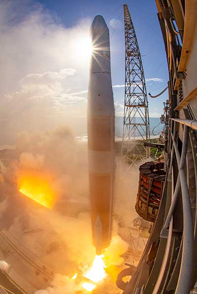
GPS III SV02 was launched on August 22, 2019, aboard a United Launch Alliance Delta IV Medium+ launch vehicle from Cape Canaveral Air Force Station, Florida.
GPS III satellites deliver positioning, navigation and timing information with three times better accuracy, and up to eight times improved anti-jamming capability than its predecessor. This is crucial for the warfighter, who will benefit from the increased power, accuracy and protections provided by the newer GPS III systems.
“This marks our second transfer of Satellite Control Authority for the GPS III program as we continue to modernize the GPS constellation with more capable and resilient systems,” said Col. Edward Byrne, chief of Production Corps’ Medium Earth Orbit Space Systems Division. “It’s only through the hard work, professionalism, and dedication of our entire government and industry partner team that we can successfully transition GPS III SV02 to operations.”
The GPS III spacecraft has a 15-year design life, 25 percent longer than the last generation of GPS satellites currently on-orbit. Additionally, it delivers new capabilities, such as a fourth civilian signal (L1C), designed to enable interoperability between GPS and international satellite navigation systems, such as Galileo. GPS III satellites will also bring the full capability of the military code (M-code) signal, increasing anti-jam resiliency in support of the warfighter.
These continued improvements and advancements to the GPS system make it the premier space-based provider of positioning, navigation, and timing services for more than four billion users around the globe.
U.S. Space Force’s Space and Missile Systems Center, located at Los Angeles Air Force Base in El Segundo, California, is the U.S. Air Force’s Center of Excellence for acquiring and developing military space systems. Its portfolio includes the Global Positioning System, military satellite communications, defense meteorological satellites, space launch, range systems, satellite control networks, space-based infrared systems and space situational awareness capabilities.
The U.S. Air Force is using a digital replica of a GPS IIR satellite to detect any cyber-security issues, reports Air Force Magazine.
Booz Allen Hamilton created the “digital twin” of the Lockheed Martin-built Block IIR GPS satellite — and then tried to hack the system.
“The satellite itself was on orbit,” BAH Vice President Kevin Coggins told Air Force Magazine. “So we built this digital model … and then we went looking for vulnerabilities. We did [penetration] testing and we saw what we could discover.”
The project is in response to a congressional mandate to test GPS for cyber vulnerabilities. Testing areas include the satellite, ground control stations and the radio-frequency links between them. BAH then conducted “man-in-the-middle” attacks on the communication links to identify potential weaknesses between the satellite and its ground control station.
The 12 Block IIR legacy satellites, launched between 1997-2004, were designed for a 7.5 year lifespan, but it will be years before they can be decommissioned.
Russia has launched another GLONASS-M satellite, according to Roscosmos, the Russian State Space Corporation.
A Soyuz-2.1b launch vehicle successfully carried the satellite to its planned orbit from the Plesetsk cosmodrome. The launch took place on schedule on March 16.
Ground-based facilities of the G.S. Titov Space Forces VKS immediately took control of the satellite. A stable telemetry connection has been established and maintained with the satellite. The onboard systems of the spacecraft are operating normally.
The launch used a Fregat booster block produced by NPO Lavochkin, part of the Roscosmos State Corporation. The satellite was manufactured by ISS, also part of Roscosmos State Corporation.
The Soyuz-2.1b launch vehicle with encapsulated GLONASS-M satellite is transported to the launchpad. (Screenshot: Russian Ministry of Defense video)
For the GLONASS constellation, a full complement of 24 satellites are set healthy. In addition, four satellites previously in the constellation are classified as spares, in maintenance or in test.
The just-launched satellite is expected to replace a currently operational GLONASS-M satellite, specifically GLONASS 735 in orbital slot 24). Of the 24 healthy satellites, one is a K1; the rest are Ms. The satellite in test is also a K1 (the first K1 to be launched).
Government officials, advisors and congressional staff gathered at NASA’s Langley Research Center on March 13. They were there to discuss the Department of Transportation’s (DoT’s) GPS Backup Technology Demonstration program and view the offerings of six different companies.
A second event to view and discuss technologies offered by the other five companies in the program is scheduled (as of this writing) for Friday, March 20, at Joint Base Cape Cod, Massachusetts.
View from Washington, D.C.
The day began with remarks by Karen Van Dyke from the U.S. Department of Transportation, as well as remarks prepared by Colonel Joseph Frankino, deputy director of the National Coordination Office, a multi-agency staff that supports the National Space-Based Positioning, Navigation, and Timing (PNT) Executive Committee, whose members were unable to attend.
Van Dyke provided an overview of the program and pointed out the increasing importance of resilient PNT. As just one example, improvements in autonomy and self-driving cars are entirely dependent upon consumers having confidence in the entire system, much of which is underpinned by PNT.
Col. Frankino’s remarks reflected the Defense Department’s commitment to and support of DoT’s resilient PNT efforts. He pointed out that the nation’s military depends upon the defense industrial base, which depends upon uninterrupted PNT.
Volpe Transportation Systems Center
The technology demonstration effort is being coordinated by Andrew Hansen from DoT’s Volpe Center. Dr. Hansen pointed out that the ongoing effort, the analysis and assessment of which is expected to be concluded in May, is a series of demonstrations vice tests. This means that the companies involved were showing what their systems could do, vice being measured against set criteria.
He also mentioned that the maturity of all the systems involved seems to have improved significantly over the last year. All are at Technical Readiness Level 6 or better. Also, that things so far had gone very smoothly with no need for any “re-dos.”
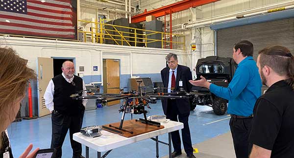
GPS and a cesium clock were being used as reference standards for the demos. Two of the systems, NextNav and Skyhook, were also demonstrated on a drone at Langley’s 150 acre open air site.
Report and Transparency
Data from the demos is not proprietary and belongs to the government which intends to make “as much of it available as possible.” DoT representatives mentioned several times their desire for maximum transparency.
Admiral (ret.) Thad Allen (left), chair of the National PNT Advisory Board, was among the attendees learning about DoT’s GPS Backup Technology Demonstration project at NASA’s Langley Research Center. (Photo: RNT Foundation)
Attendee Observations
After a day of viewing and discussing the six different technologies with their vendors, the group reconvened to offer feedback. All agreed the day was very worthwhile and complemented DoT and NASA on the event.
Kicking off the discussion, the DoT hosts remarked that the department is fully committed to GPS and its modernization. That said, there is broad recognition of the importance of other PNT systems. This is evidenced by the recent White House Executive Order on PNT.
Also, that there is no single solution that will fill the PNT needs of everyone. In fact, GPS does not serve the PNT needs of everyone. The need across sectors for a wide variety of sources to “backup” GPS is why the demonstration project includes some systems that only provide time, or only positioning.
Feedback from attendees included:
The reason for this project is that we have a 20th-century GPS and 21st-century threats. New technologies need to be examined for vulnerabilities. Security must be “baked in” from the beginning. Moderators commented that the DHS Conformance Framework was one of the tools that would help with this.
Rural and other underserved areas (such as wilderness, remote transportation networks, maritime) need PNT and should be a part of the government calculus.
Many systems depend upon infrastructure provided by others versus being self-sufficient.
In the view of many in Congress, it is good to see the demos going well. Overall, though, things are about two years late. Members and staff are very interested in when there will be an RFP and schedule for implementing the timing system mandated by the National Timing Resilience and Security Act of 2018.
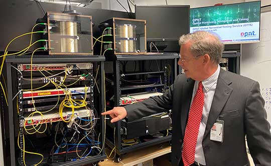
Monty Johnson of the company OPNT demonstrates precise time transfer through 100 kilometers of spooled fiber-optic cable. (Photo: RNT Foundation)
Systems Demonstrated at NASA Langley
During the course of the day, attendees had the opportunity to interact with representatives from the following companies and their systems.
The IEEE/ION PLANS Conference has been canceled. The conference — officially the IEEE/ION Position Location and Navigation Symposium (PLANS) — was scheduled to take place April 20-23 in Portland, Oregon.
“After careful consideration, the ION Executive Committee, in cooperation with the IEEE/ION PLANS program committee, made the decision this afternoon to cancel,” said ION Executive Director Lisa Beaty in an email sent March 12.
The Institute of Navigation’s (ION’s) official position has been posted here.
The ION National Office has notified PLANS authors, exhibitors and vendors and provided each with additional information pertaining to their particular relationship or circumstance.
“The ION Executive Committee will be discussing additional follow-up considerations later this month,” Beaty said.
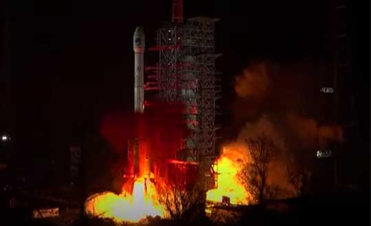
China successfully launched the penultimate Beidou navigation satellite on March 9. An official Xinhuanet news release has not yet been issued, but CGTN — a television station partially funded by the Chinese government — posted a video of the launch.
China launched the new satellite from the Xichang Satellite Launch Center in southwest China’s Sichuan Province at 19:55 Monday (Beijing Time), paving the way for its completion and full global coverage in May.
The Long March 3B/E rocket lifted off from Xichang Satellite Launch Center at 7:55 a.m. ET. The Beidou GEO-2 satellite was sent into a geosynchronous transfer orbit.
Coronavirus Fight
China has touted the BeiDou constellation’s role in helping the country fight the novel coronavirus (COVID-19) epidemic with high precision from space.
“When China was building the two makeshift hospitals — Huoshenshan (Fire God Mountain) and Leishenshan (Thunder God Mountain) in Wuhan, the epicenter of the epidemic — equipment based on the BeiDou Navigation Satellite System (BDS) provided high-precision positioning service and accelerated the construction,” stated a press release from the China Aerospace Science and Technology Corp. (CASC).
Drones based on the BDS have been utilized to spray disinfectant, according to the press release. Police in Ruichang, east China’s Jiangxi Province, used BDS-based drones to patrol crowded places to prevent intensive contact between people.
China’s Ministry of Transport sent epidemic prevention and transportation service information to more than 6 million vehicles via the BDS terminals, and provided services for the transportation of emergency materials to the areas most affected by the epidemic.
China Post Group Co. Ltd. has installed 5,000 BDS terminals on its trunk line vehicles, and used the vehicle positioning information to conduct real-time supervision and allocation, so as to ensure timely delivery of epidemic prevention materials.
In Wuhan, the BDS-based robots of the e-commerce and logistics company JD.com delivered medical materials to hospital isolation areas with high speed.
China began to construct its navigation system, named after the Chinese term for the Big Dipper constellation, in the 1990s and started serving the Asia-Pacific Region in 2012.
Over the past two years, China has successfully sent 28 BDS-3 satellites and two BDS-2 satellites into orbit.
With the system’s upgraded intelligent operation and maintenance capabilities, the BDS-3 has provided stable and accurate services, boasting a positioning accuracy of better than five meters.
China plans to launch more BDS satellites in March and May to complete the global network.