Organizers stated, “In light of the current situation caused by the coronavirus as well as related travel restrictions and resulting cancellations we unfortunately are forced to cancel the Munich Satellite Navigation Summit 2020 as we are no longer able to provide a well-ordered and appropriate program.”
Those who were attending are asked to be patient as the event organizers proceed to “sort out all necessary administrative issues.”
The summit brings together experts in industry and government; this year, it was go take place in Alte Kongresshalle, Munich, Germany.
Attendees are also told it may be possible to transfer their registration to the 2021 conference.
NASA is partnering with the New Zealand Ministry of Business, Innovation and Employment, New Zealand Space Agency, Air New Zealand and the University of Auckland to install next-generation GNSS reflectometry receivers on passenger aircraft to collect environmental science data over New Zealand.
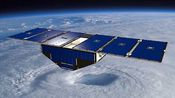
The program is part of NASA’s Cyclone Global Navigation Satellite System (CYGNSS) mission, a constellation of eight small satellites launched in 2016 that use GPS satellite signals that reflect off Earth’s surface to collect science data.
The CYGNSS satellites orbit above the tropics and their primary mission is to use GPS signals to measure wind speed over the ocean by examining GPS signal reflections off choppy versus calm water. This allows researchers to gain new insight into wind speed over the ocean and will allow them to better understand hurricanes and tropical cyclones.
Measurements over land
In addition to its primary over-water research capabilities, scientists have discovered that the CYGNSS technology is also capable of collecting valuable measurements over land, including of soil moisture, flooding, and wetland and coastal environments.
“Partnering with New Zealand offers NASA and the CYGNSS team a unique opportunity to develop these secondary capabilities over land. Taken together over time, they’ll also have an important story to tell about the long-term impacts of climate change to these landscapes,” said Gail Skofronick-Jackson, CYGNSS program scientist at NASA Headquarters, Washington.
The CYGNSS team, led by principal investigator Chris Ruf at the University of Michigan in Ann Arbor, has developed a next-generation GNSS reflectivity receiver with support from NASA’s Earth Science Technology Office. These receivers will be installed in late 2020 on one of Air New Zealand’s Q300 domestic aircraft.
Artist’s concept of one of the eight CYGNSS satellites in orbit. (Image: NASA/University of Michigan)
Aircraft overlap satellite path
As the aircraft traverses New Zealand, it will collect data from the land below, some of which will overlap with the flight paths of the CYGNSS satellites.
This overlap, which will have frequent data observations from regular commercial flights, will provide the CYGNSS team a wealth of data to use to validate and improve the CYNGSS satellite observations, said Ruf.
In addition, the varied New Zealand terrain will provide comparison points with data collected in similar terrains in other parts of the world.
“As a result of this partnership, both Air New Zealand engineers and researchers across New Zealand will now have the opportunity to work with NASA on a world-leading environmental science mission,” said Peter Crabtree, general manager of Science, Innovation and International at New Zealand’s Ministry of Business, Innovation and Employment.
Science Payload Operation Centre
The University of Auckland will host the Science Payload Operation Centre, which will begin operations and data collection in late 2020.
“Over time, the data that will be collected by these receivers could form one of New Zealand’s largest bodies of long-term environmental data, and as such it represents a wide range of research opportunities,” said radar systems engineer and project lead Delwyn Moller of the University of Auckland.
Air New Zealand will be the first passenger airline to partner with NASA to collect data for a science mission. Air New Zealand has 23 Q300s in its fleet, and if the approach is successful, the airline will explore introducing the technology more widely.
An Air New Zealand Bombadier Q300. (Photo: Air New Zealand/NASA)
“As an airline, we’re already seeing the impact of climate change, with flights impacted by volatile weather and storms. Climate change is our biggest sustainability challenge, so it’s incredible we can use our daily operations to enable this world-leading science,” said Air New Zealand Chief Operational Integrity and Standards Officer Captain David Morgan.
The agreement will enable AER to process satellite data for commercial companies that sell their Earth observation data products to government agencies and other organizations that provide customized environmental information to a range of clients.
Under the agreement, AER will adapt UCAR’s SatDAACâ software system to process observations from satellites using GNSS radio occultation to observe the atmosphere. Those observations can lead to significantly improved weather forecasts.
From basic research to industry
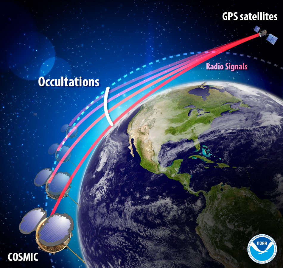
GNSS radio occultation measures the extent to which the radio signals from GNSS transmitter satellites (including GPS satellites) bend as they propagate through denser regions of the atmosphere.
The measurements can be further processed into information about temperature, pressure, and humidity in the lower atmosphere as well as the electron density in the ionosphere. The technique provides considerable accurate knowledge about a large volume of the atmosphere from near-Earth orbit down to the surface.
Image: NOAA
NASA’s Jet Propulsion Laboratory was first to use radio occultation to profile the atmospheres of Mars, Venus, and the outer planets starting in the 1960s. UCAR, in collaboration with JPL, pioneered the GNSS radio occultation observing technique for Earth’s atmosphere, building on basic research with funding from the National Science Foundation.
In 2006, UCAR began producing the first operational GNSS radio occultation data from a specialized constellation of small satellites known as the Constellation Observing System for Meteorology, Ionosphere, and Climate (COSMIC). The observations from COSMIC led to improved predictions of tropical cyclones and other storms as well as information about space weather and global climate.
A second constellation of small satellites, known as COSMIC-2, was launched in June 2019. It will provide twice as many soundings of the atmosphere with higher quality than COSMIC.
More GNSS-RO satellites coming
Now that the technology has been successfully demonstrated, additional satellites with GNSS radio occultation technology are being launched.
“This technology has moved quickly from being a research concept to providing vital information to forecasters,” said Ying-Hwa “Bill” Kuo. “The original investment in basic research is generating substantial benefits for society.”
Lead GNSS radio occultation researcher at AER Stephen Leroy said, “Earth radio occultation has a nearly 30-year history and has been a revolutionary force in numerical weather prediction and climate science in that time; and now with the commercialization of RO [radio occultation] data, we are looking forward to an explosion in RO data volume. I am really excited that we are performing the operational processing of this new data stream and expanding its scope and utility.”
The UCAR-AER agreement will likely lead to further advances in GNSS radio occultation technology, according to Bill Schreiner, director of the UCAR COSMIC Program.
“By transferring technology to the private sector, AER can take it to the next level in terms of distributing the data and finding new applications that help society,” he said. “This agreement will leverage SatDAAC’s advanced capabilities to develop new products for use by the environmental observing and prediction communities and will help us continue to innovate.”
At least three commercial enterprises are currently developing and deploying nanosatellites and microsatellites that perform GNSS radio occultation — Spire, GeoOptics and PlanetiQ — as well as several international space agencies.
AER works with governments and businesses worldwide to advance understanding of climate- and weather-related risks. The company develops analytical tools to help measure and observe the properties of the environment and translate those measurements into actionable information.
UCAR is a nonprofit consortium of 120 colleges and universities focused on research and training in the atmospheric and related sciences.
On April 2, a new museum exhibit will open that focuses on the U.S. Air Force’s role in the management of GPS satellite systems.
The National Museum of the United States Air Force is holding a grand opening event for the new GPS Exhibit from 2-3:30 p.m., with remarks by U.S. Air Force personnel involved with the exhibit followed by light refreshments.
The museum is located at 1100 Spaatz Street, Wright-Patterson Air Force Base, Riverside, Ohio.
On April 2, 2020 a new exhibit will open focusing on the U.S. Air Force role in the management of GPS satellite systems. (Artist’s concept: USAF)
History and Benefits. GPS began as a military navigation tool in the early 1960s. Later, the U.S. Air Force became the lead organization for developing the system. It manages the system, providing highly accurate position, navigation and timing information to users worldwide, for free.
The exhibit describes what GPS is and how it works by outlining satellite and ground systems and their historical development. It explains how atomic clocks and GPS satellites enable all kinds of important activities.
These include mapping and navigation for everyday users and the military, commerce, farming, construction, cell phone systems, the power grid, and climate research.
The exhibit also explains how satellite orbits work, and it outlines the problem of “space junk.”
Hands-on. Interactives and videos help all ages better understand GPS, learn how to find their location on the Earth, and see how orbits and satellites work.
The museum will be open late on opening day, allowing guests to tour the museum until 8 p.m., with an opportunity to walk inside an AC-130A. The Lockheed AC-130 gunship is a heavily armed, long-endurance, ground-attack variant of the C-130 Hercules transport, fixed-wing aircraft.
The exhibit opening will take place in the Space Gallery (fourth building).
The 6th Satellite-Based Augmentation Systems Interoperability Working Group (SBAS IWG) took place Feb. 5-7 in Delhi, India.
During the meeting, SBAS developers and operators were joined by users of the systems, with representatives of airlines, aircraft makers and avionics manufacturers. About 50 people in total attended the meeting.
“Satellite-based augmentation systems deliver the necessary accuracy, integrity, availability and service continuity for aircraft to be able to rely on them though all phases of flight, from cruising in the air to being guided down for landing,” said navigation engineer Didier Flament, head of the European Space Agency’s (ESA) EGNOS and SBAS division, representing ESA at the SBAS IWG.
The meeting covered the Southern Positioning Augmentation Network (SPAN), which had been born since IWG’s previous gathering six months ago. SPAN, a regional SBAS program, covers Australia and New Zealand.
The meeting also covered the progress of the four SBAS currently under definition or development: China’s Beidou SBAS, BDSBAS, represented by the China Satellite Navigation Office; South Korea’s KASS, represented by the Korea Aerospace Research Institute; the African and Indian Ocean SBAS, represented by the Agency for Aerial Navigation Safety in Africa and Madagascar; and the Russian Federation’s System for Differential Corrections and Monitoring (SDCM), represented by Russian Space Systems, RSS.
Current systems are mostly based around the U.S. GPS system (except for SDCM using Russia’s Glonass and BDSBAS using China’s Beidou) but plans are being laid to move to a dual-frequency, multi-constellation version making use of Europe’s Galileo, China’s Beidou and Russia’s Glonass satnav systems later this decade, IWG said.
Finally, the meeting touched on SBAS research and development, including applying SBAS to Europe’s railways.
Today, there are 10 satellite-based augmentation systems for satnav that are either in operation or active development, IWG added. The group is working to ensure that the future evolutions of all these systems will operate on a similar basis with common technical requirements, allowing the easy transition of continent-crossing air traffic from one system to another.
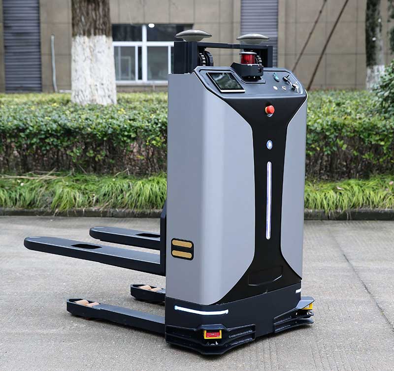
With the development of intelligent shipping ports, many port-related tools — gantry cranes, loaders and forklifts — can be made autonomous and controlled automatically. These applications use GNSS to obtain positioning and orientation data for machine operators.
In traditional container-intensive terminals, forklift drivers spend a lot of time locating the designated goods; operating the forklift itself requires highly experienced drivers. Tersus GNSS offers a positioning and orientation solution that can greatly reduce the need for experienced drivers, improve the port’s operational efficiency, reduce error rates and improve accuracy.
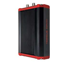
Installed on an autonomous forklift, a David Plus receiver and anti-interference GNSS dual antenna calculates positioning solutions, enabling operators to locate exactly where the target goods are and guide the forklift to them via the quickest, most convenient routes.
The David Plus’s compact design can be easily installed on even small forklifts without affecting normal operation. The David Plus obtains high-precision positioning and orientation values by connecting via wireless to an Ntrip network, and then forwards corrections to the port-dispatching system as raw data.
The David Plus supports GPS L1/L2, GLONASS L1/L2 and BeiDou B1/B2 from the primary antenna, and GPS L1/GLONASS L1 or GPS L1/BeiDou B1 from the secondary antenna. Its 384 channels can capture numerous satellite signals within a short time.
Image: Tersus GNSS
With an IP67-rated enclosure, the David Plus GNSS receiver is built for outdoor environments such as shipping ports. A palm-sized unit, it can be easily integrated with various application systems. As a backup data-saving measure, 4 gigabytes of built-in memory record data for post-processing.
A manned forklift can benefit from the positioning data. When the forklift reaches the designated position in the stack, the heading antenna will calculate the correct lift height of the forklift arm. This provides a suitable height for handling the cargo, and prevents accidents such as the cargo falling.
For a fully autonomous forklift, the system will automatically analyze the orientation data and lift the forklift arm to the corresponding height of the cargo. It will then retrieve and lower the cargo to a safe height, and automatically drive it to the new storage point. During this process, additional infrared obstacle avoidance sensors can accurately identify the distance between the forklift and the cargo, avoiding inadvertent collisions.
The positioning and orientation data obtained by the David Plus can be shared with third-party software and hardware. For instance, port terminal systems can configure containers to capture distribution information and instructions. By importing the positioning information of the forklift equipped with David Plus into the system in real time, it is possible to calculate the optimal driving trajectory to the final cargo delivery point.
The Tersus David Plus positioning and orientation solution can combine its own high-precision positioning and orientation data with other automation system hardware and software to form a complete forklift unmanned/manned automated driving and handling solution.
We’ve come a long way since the inception of GPS. Today, location often is taken for granted, but that’s true of every mainstream technology.
It’s absolutely remarkable how far the technology has evolved. From receivers that were as big as backpacks to tiny chipsets supporting multi-constellation dual-band GNSS receivers in smartphones with antennas that are etched into the body of cell phones, it’s really an amazing technology.
I’ve had the privilege to work on GPS in phones since before “smart” appeared in front of them. And it’s truly amazing to see how “GPS has revolutionized our day-to-day lives.” But this is not my quote.
In January at the Google campus in Mountain View, California, we hosted Dr. Brad Parkinson (widely known as the Father of GPS) who gave a talk on this subject. He was the one who called this a revolutionary technology, and that had been a stealthy revolution. Frank van Diggelen secured Brad to come to Google to give this talk.
His talk was titled “GPS for Humanity.” In the talk, available on YouTube (see below), Brad goes over first hand how, over the past 30 years, this new utility came into being. It came into the fabric of our worldwide society, creating dependencies that did not exist before.
He detailed how GPS was created, what technologies were essential to its success, all the various ways that GPS keeps crucial processes intact, and how it supports a $1.4 trillion economic impact that this system brings us today.
It was a privilege and honor to have Brad give a candid and timely talk, and I hope you enjoy it as much as we did!
To watch his talk, search for “Brad Parkinson Talks at Google” on Google or YouTube. Or follow the link
Steve Malkos is the lead technical program manager in the Android Context Group at Google.
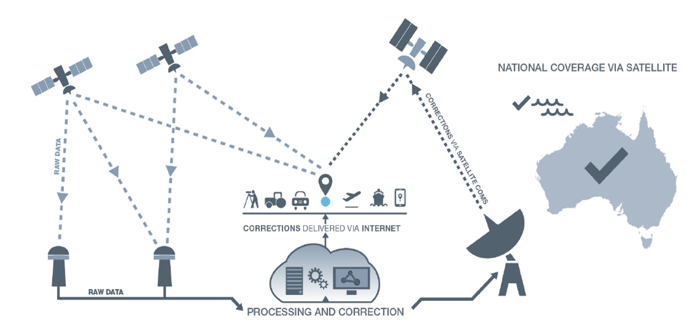
Australia and New Zealand are partnering to roll out satellite technology that will be able to pinpoint a location on Earth to within 10 centimeters, unlocking more than $7.5 billion in benefits for industries in both countries.
Prime Minister Scott Morrison and New Zealand’s Prime Minister Jacinda Ardern committed jointly to implement a satellite-based augmentation system (SBAS), to operate across Australia and New Zealand, at the Australia-New Zealand leaders’ meeting held Feb. 28.
The system will improve the accuracy of GPS and other positioning services from the current five to 10 meters to as little as 10 centimeters across Australia and New Zealand without the need for mobile or internet coverage.
The new project follows 18 months of successful trials that tested 27 projects across a range of industries. It will be delivered by Geoscience Australia and Land Information New Zealand under the joint science research and innovation treaty.
Minister for Resources, Water and Northern Australia Keith Pitt said the project, to be operating by 2023, will have significant benefits to a range of industry sectors including mining, agriculture and transport.
“We welcome New Zealand’s commitment to join Australia in rolling out this exciting new technology, which will deliver substantial economic benefits for both countries,” Minister Pitt said.
“An independent analysis by Ernst and Young (EY) has found improved positioning technology will deliver more than $6.2 billion in benefits for Australia, and more than $1.4 billion in benefits for New Zealand, over the next 30 years.
“Trial projects have also found the system can make our roads and rail systems much safer, and can improve the way farmers manage their land, crops and livestock. For the resources sector, the technology can track vehicles and improve site surveys to enable precise extraction of deposits.”
Industry, Science and Technology Minister Karen Andrews said the project will complement Australia’s other investments in space to drive economic growth and create new jobs.
“The Morrison Government is backing these types of technologies because of the positive impact they have on the lives of everyday Australians — from the discoveries that make life easier through to growing industries that create high-value jobs,” Minister Andrews said.
“Many industries stand to benefit from this technology. It could help improve safety and efficiency in aviation and shipping and will be crucial to the development of autonomous vehicles.
“This work also supports our government’s broader commitment to triple the size of the space sector to $12 billion and an extra 20,000 new jobs by 2030.”
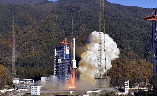
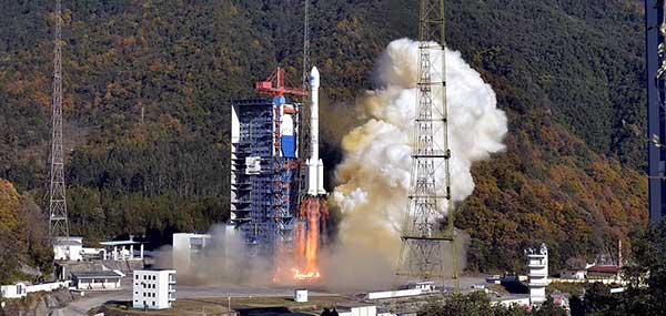
Four new satellites of the BeiDou Navigation Satellite System (BDS) have passed tests in orbit and joined the system to provide positioning, navigation and timing services, according to China news service Xinhuanet.
The four satellites include the 47th, 48th, 52nd and 53rd satellites of the BDS family, according to China’s Satellite Navigation System Management Office.
All of them, operating in medium Earth orbit, were developed by the China Academy of Space Technology under the China Aerospace Science and Technology Corporation.
The 47th and 48th BDS satellites were launched on Sept. 23, 2019, and the 52nd and 53rd BDS satellites were launched on Dec. 16, 2019.
Two to the Last. The China Satellite Navigation System Management Office said the last two Beidou-3 satellite launches will take place in March and May, and complete the Beidou system.
China began to construct its navigation system, named after the Chinese term for the Big Dipper constellation, in the 1990s and started serving the Asia-Pacific Region in 2012.
Over the past two years, China has successfully sent 28 BDS-3 satellites and two BDS-2 satellites into orbit.
China plans to launch more BDS satellites in March and May to complete the global network.
L3Harris Technologies has reached a major milestone in the U.S. Air Force’s Navigation Technology Satellite-3 (NTS-3) project — passing the preliminary design review that defines the spacecraft’s path to delivery and allows the program to move to the next phase of development.
NTS-3 is an experimental program examining ways to improve the resiliency of the military’s positioning, navigation and timing capabilities. It will also develop key technologies relevant to the Global Positioning System (GPS) constellation, with the goal of future transition to the GPS IIIF program.
In collaboration with the Air Force Research Laboratory, Space and Missile Systems Center, and United States Space Force, L3Harris is combining experimental antennas, flexible and secure signals, increased automation, and use of commercial command and control assets.
Satellite NTS-3 closeup. (Illustration: Lt. Jacob Lutz, AFRL Space Vehicles Directorate)
“The NTS-3 vanguard is an experimental, end-to-end demonstration of agile, resilient space-based positioning, navigation, and timing,” said Arlen Biersgreen, Air Force NTS-3 program manager. “It has the potential for game-changing advancements to the way the Air Force provides these critical capabilities to warfighters across the Department of Defense. The commitment demonstrated by United States Space Force to partner with AFRL and support technology transition was a key element in NTS-3 being designated as an Air Force vanguard in September 2019.”
The Space Enterprise Consortium selected L3Harris for the $84-million contract in 2018 as the prime system integrator to design, develop, integrate and test NTS-3, including ground mission applications.
“We have moved from contract award to finishing an early design review in under one year, which is an amazing accomplishment for a satellite development program that normally takes twice that amount of time,” said Ed Zoiss, President, Space and Airborne Systems, L3Harris. “We have proven we can move quickly to support the Air Force’s go-fast mission requirements.”
L3Harris has more than 40 years of experience transmitting GPS navigation signals. The company’s technology has been onboard every GPS satellite ever launched.
Turkey has opened GNSS base station in Antarctica, according to Sputnik News. The station can track changes in the location of icebergs and transmit photos of Antarctica’s surface, as well as process data from GPS, GLONASS and Galileo.
“A GNSS satellite navigation base station was set up within the framework of the fourth Turkish scientific expedition to Antarctica,” said Turkish Industry and Technology Minister Mustafa Varank, as quoted by the national Anadolu news agency. “A group of specialists from the Turkish General Directorate of Mapping has built Turkey’s first GNSS base station abroad.”
The 24-member Turkish research team joins 15 scientific projects in the Earth, life, and marine sciences. The expedition is being conducted under the auspices of the Turkish Presidential Administration and the Ministry of Industry and Technology and coordinated by the TUBITAK.
On Feb. 12, the White House released an “Executive Order on Strengthening National Resilience through Responsible Use of Positioning, Navigation, and Timing Services.”
It is gratifying to see White House attention to this issue. The increase in public awareness it brings will benefit individual users and the nation as a whole.
The order also hints at market driven solutions that could quickly improve America’s PNT resilience.
Needless delays
Unfortunately, the order fails to direct immediate action on this critical national and economic security issue. Instead it needlessly pushes most action and responsibility off for a year or more to do “more study.”
This is hard to understand as most of the “more study” has already been completed. For example, the order tells the Department of Commerce to take up to a year to examine PNT use in various sectors, and identify vulnerabilities and user needs. The Department of Homeland Security has already completed a National Risk Assessment and, according to congressional staff, has recently completed a report on user requirements mandated in 2017’s National Defense Authorization Act.
The Office of Science and Technology Policy is given a year to develop a plan to test robust and resilient non-GNSS PNT services (but is not required to actually do any testing). Congress mandated such a test program in 2017 and funded it with $10 million in 2018. After much delay, the Department of Transportation will complete the testing in May of this year.
The order gives the Department of Commerce six months to make available a time source to support critical infrastructure. For more than 60 years, the nation’s master clock has been available to users at the department’s NIST Laboratory in Boulder, Colorado.
Note the challenge has not been the clock, but that the nation has no way — other than vulnerable GPS signals — to distribute time at the needed level of accuracy to millions of critical infrastructure nodes. Government studies in 2007 and 2014 determined that the best way to do this was with a ground-based system. The Department of Transportation’s ongoing testing program is examining this issue again.
Market-driven solutions
Aside from increasing public awareness, the best thing the Executive Order does is to point a way forward for market-driven resilient PNT solutions.
The order calls for federal contracts to (in 21 months, if everyone does their jobs on time) require that vendors use existing and new resilient PNT sources.
If this eventually happens, the government could leverage its enormous influence in the market and stimulate creation of one or more commercial distribution systems for resilient, non-GNSS PNT. This is a great concept, and very much in keeping with America’s tradition of letting market forces solve some of its biggest problems.
But this solution will not spring into life on its own.
No commercial entity will invest tens of millions of dollars, or more, in a PNT system without assurance in advance of an income stream. Especially since federal contracting officers can and will waive the requirement if offerors cannot reasonably meet it.
If stimulating a market solution is the administration’s intent, it must stay actively involved and encourage the process for some time to come.
This includes complying with the 2018 law that requires establishment of at least one wireless, terrestrial, difficult-to-disrupt source to back up the timing signals provided by GPS.
Fortunately, this can be done by leveraging the free market at minimal cost and with little administrative effort.
By contracting to subscribe to a commercial service that will provide resilient PNT signals, the government need only invest a relatively small yearly sum using a fairly simple contract vehicle. Such a contracting technique has been used before with great success.
In 2007 the Federal Aviation Administration (FAA) did this as a way to establish its ADS-B aviation tracking and safety network. Once the subscription contract was let, the commercial provider was able to get financing and quickly build out the system.
Today, the FAA gets the information it needs, doesn’t have the headache of owning and maintaining a large network, and even shares in the revenue the system owner earns from selling data to other companies.
Additional leadership needed
It is important to remember that, regardless of the issue, presidential pronouncements are not enough.
In 2004, President G.W. Bush directed a number of actions to protect the nation’s critical PNT, including establishment of a GPS backup capability. While 16 years later his directive is still official executive branch policy, that mandate and many others from his order are still unexecuted.
Real improvements to PNT resilience and our nation’s security depend not on one-time pronouncements, but continued leadership focus and engagement.
This is always a challenge for initiatives driven by the White House. It will be doubly so in this case as there is no clear department leader for civil PNT issues the administration can rely on while it attends to the next issue of the day.