Category: GNSS

  • Galileo now replying to SOS messages worldwide

    Galileo now replying to SOS messages worldwide

    News from the European Space Agency

    As well as providing global navigation services, Europe’s Galileo satellite constellation is contributing to saving more than 2,000 lives annually by relaying SOS messages to first responders. And from now on the satellites will reply to these messages, assuring people in danger that help is on the way.

    This ESA-design return link system, unique to Galileo, was declared operational this week, during the 12th European Space Conference in Belgium. The delivery time for the return link acknowledgement messages from initial emergency beacon activation is expected to be a couple of minutes in the majority of cases, up to 30 minutes maximum, depending primarily on the time it takes to detect and locate the alert.

    Cospas-Sarsat rescue beacon activated. Its signals are picked up by satellites in orbit, including Galileo. (Photo: GSA)
    Cospas-Sarsat rescue beacon activated. Its signals are picked up by satellites in orbit, including Galileo. (Photo: GSA)

    “Anyone in trouble will now receive solid confirmation, through an indication on their activated beacon, informing them that search and rescue services have been informed of their alert and location,” explains ESA’s Galileo principal search and rescue engineer Igor Stojkovic. “For anyone in a tough situation, such knowledge could make a big difference.”

    All but the first two out of 26 Galileo satellites carry a Cospas-Sarsat search and rescue package. At only 8 kg in mass, these life-saving payloads consume just 3 percent of onboard power, with their receive-transmit repeater housed next to the main navigation antenna.

    Image: ESAPhoto:
    Image: ESA

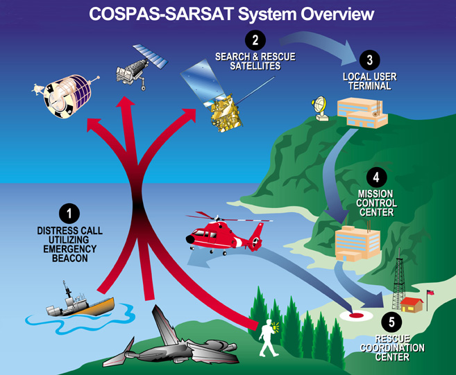
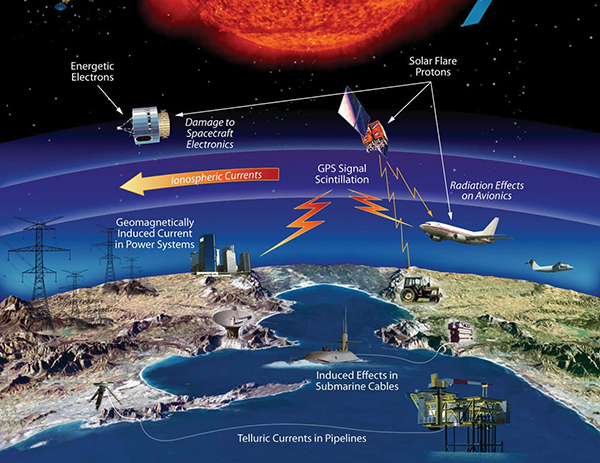
    Founded by Canada, France, Russia and the US in 1979, Cospas-Sarsat began with payloads on low-orbiting satellites, whose rapid orbital motion allows Doppler ranging of distress signals, to pinpoint their location. The drawback is these fly so close to Earth that their field of view is comparatively small.

    Geostationary satellites went on to host Cospas-Sarsat payloads. These see much more of the planet, but because they are motionless relative to Earth’s surface, Doppler ranging is not possible.

    Medium-orbiting satellites such as Galileo – orbiting at 23 222 km altitude – offer the best of both worlds, providing a wide ground view by multiple satellites combined with time-of-arrival and Doppler ranging techniques to localise SOS signals. This improves the maximum signal detection time from four hours to less than five minutes, down to one or two kilometres (within a formal specification of 5 km within 10 minutes).

    Galileo’s Search and Rescue service is Europe’s contribution to Cospas-Sarsat, operated by the European Global Navigation Satellite System Agency, GSA, and designed and developed at ESA. As the overall Galileo system architect and design authority, ESA has been responsible for the interface between the core Galileo infrastructure to the Return Link Service Provider facility, procured by the European Commission and operated by French space agency CNES.

    The Cospas-Sarsat satellite repeaters are supplemented by a trio of ground stations at the corners of Europe, known as Medium-Earth Orbit Local User Terminals (MEOLUTs), based in Norway’s Spitsbergen Islands, Cyprus and Spain’s Canary Islands and coordinated from a control centre in Toulouse, France. This trio is soon to become a quartet, with a fourth station on France’s La Reunion Island in the Indian Ocean under development.

    The satellites relay distress messages to these MEOLUTs, which then relay them to local search and rescue authorities.

    a public demonstration of Galileo's return link service was performed at the Cospas-Sarsat Joint Committee Meeting in Doha in Qatar in summer 2019. ()Photo: ESA)
    A public demonstration of Galileo’s return link service was performed at the Cospas-Sarsat Joint Committee Meeting in Doha in Qatar in summer 2019. ()Photo: ESA)

    The service’s return link message capability was developed as an inherent part of the Galileo system. The messages are relayed to the individual beacons that sent the original distress call by being embedded within Galileo signals broadcast from satellites in their view.

    “The switching on of the return link service was enabled by a thorough test campaign carried out by ESA, with the support of the GSA and CNES,” adds Igor. “We needed to be sure the service remains reliable even with multiple distress calls being replied to at once.”

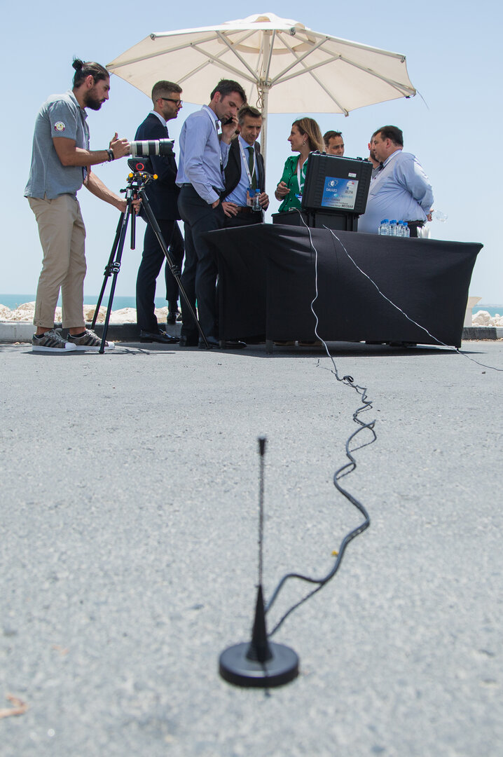
    A key milestone was a public demonstration of the return link service, performed at the Cospas-Sarsat Joint Committee Meeting in Doha in Qatar last summer.

    “The return link is a joint service of Cospas-Sarsat and Galileo and therefore agreement by Cospas-Sarsat was crucial,” adds Igor.

    “This acceptance was achieved through long discussions led by the European Commission at the Cospas-Sarsat Council last November, supported by plentiful documentation of simulations and test results provided by ESA and CNES.”

  • 4th GPS civilian signal goes live

    4th GPS civilian signal goes live

    A new GPS civilian signal is now available for use. The new signal is stronger, more accurate, more resilient to interference events, and interoperable with European Galileo system.

    Researchers from the Finnish Geospatial Research Institute (FGI) recorded the new civilian signal transmitted by the first GPS III operational satellite.

    On Jan. 13 at 21:29 Finnish time, the first GPS III satellite (SVN74) was marked healthy after extensive operational testing in orbit. The satellite broadcasts PRN04 identification codes. It also transmits a new GPS civilian signal, known as L1C, different than the legacy L1 C/A signal used nowadays.

    10 times longer

    The two signals are transmitted at the same frequency, but L1C codes are 10 times longer than L1 C/A. This makes the signal more robust to interference when multiple satellites are tracked on the same frequency band.

    “Marking a satellite health means receivers can use this satellite in their positioning, navigation and timing applications,” said Octavian Andrei, senior research scientist at the Finnish Geospatial Research Institute (FGI). “L1C is the 4th GPS signal for the civilian use.” The Finnish Geospatial Research Institute is a part of the National Land Survey of Finland.

    The other three civilian signals of GPS are L2C, L5 and L1 C/A.


    For more on the L1C signal, also see First light: Broadcast of L1C by GPS III,


    Interoperable with the European GNSS signalL1C signal is transmitted on L1-band at 1575.42 MHz. It is meant to replace the legacy C/A signal in the future. L1C allows for the first time GPS compatibility and full interoperability with signals from other satellite systems, such as E1 signal from the European Galileo.

    The interoperability with Galileo is further enhanced by transmission of the inter-system timing biases; that is, the GPS-Galileo Time Offset. All these improvements will bring further benefits and developments to the GNSS market and civilian users in general.

    Ionosphere no problem with dual-frequency

    Andrei said the new signals means “Exciting times ahead for the civilian users and applications that demand precise satellite positioning and navigation. Most of the effects due to the ionosphere layers of the atmosphere are removed by combining signals from two frequency bands sufficiently apart from each other. This is the case with L1 and L2 or L1 and L5. All these civilian signals are stronger and more robust than ever before,” he explained.

    The satellite signals are affected by errors while travelling through the atmosphere. The main errors are due to the ionosphere, which is a dispersive medium and frequency dependent. The latter proves to be actually a significant benefit for the precise applications.

    The new signal (L1C, marked with blue) is 3-5 dBHz stronger and more robust than the legacy L1 C/A signal (marked with orange). (Image: Octavian Andrei)
    The new signal (L1C, marked with blue) is 3-5 dBHz stronger and more robust than the legacy L1 C/A signal (marked with orange). (Image: Octavian Andrei)

    More than 99 % of the ionosphere effect is removed by forming special linear combination of signals observed on two different frequencies. This is the main reason why high-precision is achieved with dual-frequency receivers.

    FinnRef network ready for new satellites and signals

    “Two GPS III satellites have been launched until now and two more are expected to be launched during 2020. With signals from four satellites, we will also be able to estimate L1C-only positions,” Andrei said.

    The first GPS III satellite SVN74, nicknamed Vespucci, was launched on Dec. 23, 2018. The second satellite SVN75, nicknamed Magellan, was launched on Aug.22, 2019. The third and the fourth satellite are planned to be launched in March and July during 2020. The first L1C testing signals were recorded at the FinnRef station in Metsähovi on April 5, 2019.

    FinnRef national network includes state-of-the-art multi-constellation tracking stations distributed around Finland. These stations are capable of tracking multiple satellite signals on multiple L-band frequencies from almost 120 GNSS satellites, including the European Union’s Galileo, US GPS, Russian GLONASS, and Chinese BeiDou constellation.

    Using new signals often requires updates to station equipment, usually meaning firmware updates on the receiver software. After the new firmware enabling L1C tracking is properly tested, the receivers will be updated and then whole FinnRef will start tracking GPS L1C.

  • Seen & Heard: Pedestrian safety, canoe tracking

    Seen & Heard: Pedestrian safety, canoe tracking

    “Seen & Heard” is a monthly feature of GPS World magazine, traveling the world to capture interesting and unusual news stories involving the GNSS/PNT industry.


    Keeping canoeists afloat

    The United Kingdom’s Hire a Canoe company has installed Kinesis trackers on its fleet to manage transport of clients to and from their water sport activities. Real-time traffic updates and live Estimated Time of Arrival calculations help manage riverside customer pickup, while advanced geofencing provides instant notification if a canoe, kayak or paddle board leaves a defined zone during off hours.


    Moscow historical district. (Photo: poludziber/iStock Editorial/Getty Images Plus)
    Moscow historical district. (Photo: poludziber/iStock Editorial/Getty Images Plus)

    Glonass aims for pedestrian safety

    Russian company Glonass is investing RUB 4–5 million in a mobile application aimed at pedestrian safety, reports Telecompaper. The app will warn pedestrians using smartphones and headphones of approaching cars, based on an AI collecting data from smart traffic lights. Tests will take place in 2020 in the Samara, Volgograd, Tomsk, Kursk, Tambov and Moscow regions.


    Image: Vladimir Obradovic/iStock/Getty Images Plus
    Image: Vladimir Obradovic/iStock/Getty Images Plus

    GPS spoofing service

    Virtual private network (VPN) Surfshark has added GPS Spoofing to its Android VPN. The new optional feature allows users to shield their online presence from unsolicited tracking by giving them the ability to change their device’s physical GPS location. The new feature is for “privacy conscious people” who want “to keep their physical location information only to themselves.” Instead of the user’s location, the app provides one of the Surfshark VPN server locations.


    Image: Skytruth
    Image: Skytruth

    ‘Spoofing circles’ appear in China

    “GPS spoofing circles” have been discovered at 20 locations along the Chinese coast, according to the non-profit environmental group Skytruth. Of the locations observed, 16 were oil terminals; the others were corporate and government offices. The spoofing in Shanghai resulted in reported positions from ships, fitness trackers and other GPS-enabled devices forming circles some distance from the shore — a phenomenon first observed by the non-profit C4ADS. Professor Todd Humphreys briefed the phenomena at an Institute of Navigation conference in September, and MIT Technology Review published an article about it in November 2019.

  • Working together for a more navigable world

    Working together for a more navigable world

    “Diverse teams bring diverse ideas to the table, and that’s the best way to progress.”

    So said Professor Sheila Rowan, the UK government’s chief scientific advisor to Scotland, opening the Royal Institute of Navigation’s 2019 International Navigation Conference. Professor Rowan’s comments set the scene perfectly. Success in navigation is no longer about just getting a fix, or even an accurate fix. To succeed as a system or application provider, diversity and collaboration are key, whether it be multiple disciplines and the skills that go with them, or a mix of ages, beliefs and backgrounds. So, what were some key messages to emerge from four days of working together?

    John Pottle opens the 2019 International Navigation Conference sponsored by the Royal Institute of Navigation (RIN). (Photo: RIN)
    John Pottle opens the 2019 International Navigation Conference sponsored by the Royal Institute of Navigation (RIN). (Photo: RIN)

    More practical help for non-experts wanting to improve resilience in positioning, navigation and timing (PNT) is needed. The top request from delegates at the pre-conference short course was for more detailed and specific information on threats to PNT. Of particular interest were how to measure the impacts and test the merits of various mitigation approaches. In other words: how to assess risk? How to decide what steps to take?

    User acceptance and regulatory/legal structures for driverless vehicles are greater challenges than the positioning and communications technology. In the UK and across Europe, projects are under way to evaluate good practices for so-called “beyond line of sight” drone flights. For driverless cars, while huge strides have been taken to enable secure and resilient absolute and relative positioning, much remains to be done. Practical issues were highlighted, such as over-cautious vehicles and a tendency for driverless cars to make occupants feel more travel sick. So work needs to be done to avoid a stressfully slow and sickly experience.

    Skills and knowledge are changing — and education/training needs to, too. A major developed-world problem is that the experts with experience who have seen generation after generation of technology evolution are now in their later careers or retired. Because of the wealth of knowledge vested in these individuals — we can all think of some, I’m sure — organizations have tended to over-rely on them. A key theme of the conference closing plenary was that the community wants to do more to collaborate — that word again — to define training needs and figure out how to deliver the skills that are needed today and tomorrow.

    The next couple of years bring fewer, bigger navigation conferences in Europe. The European Navigation Conference (ENC) 2020 takes place in Dresden, May 11–14, organized by the German Institute of Navigation, DGON. ENC2021 will be combined with the triennial global congress of the International Association of Institutes of Navigation (IAIN), Nov. 15–18, 2021, in Edinburgh, organized by the Royal Institute of Navigation.

    Please save the dates — joining these events is rewarding and stimulating as we work together toward a more navigable world.


    John Pottle is director of the Royal Institute of Navigation.

  • 2nd Space Operations Squadron sets first GPS III healthy and active

    2nd Space Operations Squadron sets first GPS III healthy and active

    By Staff Sgt. Matthew Coleman-Foster, 50th Space Wing Public Affairs

    The 2nd Space Operations Squadron set Satellite Vehicle Number-74 (SVN-74, the first GPS III satellite) as healthy and active to users on the 2nd SOPS operations floor.

    Setting SVN-74 healthy and active means the satellite will be available for use by military and civilian GPS users around the world as part of the constellation currently maintained by the squadron. This makes the satellite the first iteration in the GPS III family to join the active constellation following its launch Dec. 23, 2018.

    Capt. Ryan Thompson, 2nd SOPS assistant director of sustainment, said various training modules and upgrades were instrumental in making the satellite operational.

    “In order to operate GPS III, we first had to install Architecture Evolution Plan 8.0,” he said. “This allowed our squadron to control the new satellite without a next generation operational control system. The 2nd SOPS training and evaluations flight was able to expeditiously give our operators top-up training that allowed them to become comfortable with the new satellite.”

    The GPS III vehicle family provides new capabilities vital to ensuring the fidelity of the constellation and signal in the contested, degraded and operationally limited environments.

    According to the Lockheed Martin press release, GPS III satellites have three times better accuracy and up to eight times improved anti-jamming capabilities than their predecessors, and a design life extending 25 percent longer than the newest GPS satellites on-orbit today. GPS III’s new civil signal will also make it the first GPS satellite to broadcast a compatible signal with other international global navigation satellite systems, like Galileo, improving connectivity for civilian users.

    2nd SOPS is already preparing for the second GPS Block III vehicle in orbit, awaiting its day to become healthy and active.

    “There are vehicles currently projected to be put into the constellation and then following this there will be the Block III-F follow-on vehicles,” said Capt. Kaoru Elliot, 2nd SOPS assistant director of operations. “With those vehicles in place, all of those capabilities will come into the next decade.”

    A third vehicle for GPS III is scheduled for launch later this year.

    “It [GPS Block III vehicle two] is being managed currently by Lockheed Martin,” Elliott said. “They are the ones actually getting the satellites up there and once it is up in orbit, they make sure everything is good before handing it over to us.”

    The work within 2nd SOPS to ensure SVN-74 is healthy and active in the constellation shows their commitment to continue providing the gold standard of position, navigation, and timing to 4 billion users around the world.

    Second Lt. Kelley McCaa, 2nd Space Operations Squadron satellite vehicle operator, and Airman 1st Class John Garcia, 2nd SOPS satellite systems operator, set satellite vehicle number-74, the first iteration of GPS Block III vehicles, as healthy and active to users Jan. 13, 2020, Schriever Air Force Base, Colorado,. Setting the vehicle healthy and active makes the satellite available for use by military and civilian GPS users around the world for agriculture, banking and navigation. (Photo: U.S. Air Force/Staff Sgt. Matthew Coleman-Foster)
    Second Lt. Kelley McCaa, 2nd Space Operations Squadron satellite vehicle operator, and Airman 1st Class John Garcia, 2nd SOPS satellite systems operator, set satellite vehicle number-74, the first iteration of GPS Block III vehicles, as healthy and active to users Jan. 13, 2020, Schriever Air Force Base, Colorado,. Setting the vehicle healthy and active makes the satellite available for use by military and civilian GPS users around the world for agriculture, banking and navigation. (Photo: U.S. Air Force/Staff Sgt. Matthew Coleman-Foster)
  • First GPS III satellite now available

    First GPS III satellite now available

    CGSIC logo

    The U.S. Air Force Second Space Operations Squadron (2 SOPS) has issued a statement that the first GPS III satellite is available for backup. While occupying the same plane as SV-68, the new satellite is broadcasting healthy, usable signals and is an active part of the constellation in the vicinity of slot F3 near SV-68.

    On. Jan. 13, 2 SOPS issued an Initial Use (USABINIT) NANU for SVN-74, the first of the new generation of GPS-III satellites, according to Rick Hamilton, CGSIC executive secretariat.

    SVN-74/PRN-04 was launched on Dec. 23, 2018. Now, having successfully undergone rigorous operational testing on orbit, the satellite has taken its place, backing up SVN-68/PRN-9 at F3 in the active GPS constellation.


    NOTICE ADVISORY TO NAVSTAR USERS (NANU) 2020004

    SUBJ: SVN74 (PRN04) USABLE JDAY 013/1734

    NANU TYPE: USABINIT
    NANU NUMBER: 2020004

    NANU DTG: 131735Z JAN 2020

    REFERENCE NANU: N/A

    REF NANU DTG: N/A

    SVN: 74

    PRN: 04

    START JDAY: 013

    START TIME ZULU: 1734

    START CALENDAR DATE: 13 JAN 2020

    STOP JDAY: N/A

    STOP TIME ZULU: N/A

    STOP CALENDAR DATE: N/A

    CONDITION: GPS SATELLITE SVN74 (PRN04) WAS USABLE AS OF JDAY 013
    (13 JAN 2020) BEGINNING 1734 ZULU.

    POC: CIVILIAN – NAVCEN AT 703-313-5900, HTTPS://WWW.NAVCEN.USCG.GOV
    MILITARY – GPS OPERATIONS CENTER at HTTPS://GPS.AFSPC.AF.MIL/GPSOC, DSN 560-2541,

    COMM 719-567-2541, [email protected], HTTPS://GPS.AFSPC.AF.MIL

    MILITARY ALTERNATE – JOINT SPACE OPERATIONS CENTER, DSN 276-3514,

    COMM 805-606-3514, [email protected]

  • Space weather research the focus of US House bill

    Space weather research the focus of US House bill

    The U.S. House Committee on Science, Space and Technology has approved legislation to coordinate federal government space weather research. Included in the bill is a finding that space weather adversely affects space-based position, navigation and timing (PNT).

    ‘‘The effects of severe space weather on the electric power grid, satellites and satellite communications and information, aviation operations, astronauts living and working in space, and space-based position, navigation, and timing systems could have significant societal, economic, national security and health impacts.”

    If passed, the bill would mandate coordination of government space weather forecasting and related operations, with input from academia, international groups and commercial firms affected by space weather.

    The Promoting Research and Observations of Space Weather to Improve the Forecasting of Tomorrow (PROSWIFT) Act was introduced in November by Democrat Ed Perlmutter of Colorado and Republican Mo Brooks of Alabama, reports Space News. Similar legislation, the Space Weather Research and Forecasting Act, was approved in April by the Senate Commerce, Science and Transportation Committee.

    PROSWIFT calls for the National Science and Technology Council to establish an interagency working group on space weather that includes the National Oceanic and Atmospheric Administration (NOAA), NASA, the National Science Foundation, Defense Department and Interior Department. It directs members of the interagency working group to collaborate with the international community, academia and the commercial space weather sector.

    PROSWIFT also tasks NOAA with establishing a space weather advisory group with members representing academia, the commercial space weather sector and space weather data customers.

    Read the bill here.

    The effects of space weather on critical Earth systems. (Image: NASA)
    The effects of space weather on critical Earth systems. (Image: NASA)
  • GPS backup demonstration projects explained

    GPS backup demonstration projects explained

    The U.S. Department of Transportation awarded contracts to 11 companies to demonstrate their technologies’ ability to act as a backup for GPS.

    We wanted to know a bit more about what each of them were going to demonstrate, so we asked each for an explanation. Most provided just that, so much of what appears here is in their own words. A couple of companies sent us a whole lot more than 100 words and two did not respond. For those, we did our best with the materials they sent us and other publicly available materials.

    Wi-Fi, Cellular, Ultra-Wideband

    PhasorLab plans to demonstrate its Hyper Sync Net (HSN) technology as a backup to GPS-based PNT solutions. HSN is a self-organizing mobile mesh network capable of maintaining high-precision time (<<1 ns) and frequency (<<1 ppb) synchronization throughout the whole network as well as an instantaneous 3D locational map of the whole mesh network requiring as little as a single master reference node.

    The HSN can be deployed either as a set of fixed reference nodes providing time and positioning references to other mobile UE clients, which is like a terrestrial version of GPS, or as a private ad-hoc mobile mesh network where all members are expected to be mobile.

    Skyhook Technology’s system is powered by an immense database — created and maintained by Skyhook — that contains more than five billion geolocated access points and 200 million cell base station IDs, enabling it to accurately locate phones and devices worldwide. The user is not required to be connected to a Wi-Fi network for the system to work. The scan will simply detect Wi-Fi access points in the local area based on signals sent periodically (or on demand) according to the IEEE 802.11 specifications. Many devices will acquire information on as many as 100 access points in the surrounding area. Skyhook’s Wi-Fi positioning system (WPS) will compute an estimated end-user location based on each of the signal sources independently, and compute an optimal hybrid location estimate from all sources.

    Fiber/Network

    OPNT’s Global Terrestrial Timing Service (GTTS) provides GPS-independent timing-as-a-service over global fiber-based networks. Trading off cost versus service-level agreement (SLA)-backed accuracy, standard network connectivity offerings and bidirectional fibers are combined to meet application needs. As will be demonstrated with simulations of National Institute of Standards and Technology (NIST) and the two U.S. Naval Observatory (USNO) clocks, OPNT’s fully redundant solution receives its core Coordinated Universal Time (UTC) timing directly from the non-maskable interrupts (NMIs).

    The demonstration will include sub-nanosecond stability with fault detection and glitchless recovery. Using the precision-timed fiber base, OPNT will also demonstrate precision monitoring of wireless signals with continuous, real-time corrections to keep the wireless transmissions and its local timing source in sync.

    Seven Solutions’ core technology is called White Rabbit and was born at CERN. In this demonstration, Seven Solutions plans to showcase the performance of this technology, both on local and wide-area deployments, and explain the capabilities in terms of interoperability (integrating multiple synchronization technologies, i.e. IEEE 1588 PTP, NTP, PPS, 10-MHz clocks), scalability and resiliency. The goal is to provide a reference technology that can provide very stable time references over fiber in GPS-denied scenarios as a backup source or to complement other PNT solutions that need timing distribution at their core.

    eLoran

    Hellen Systems’ team said it is excited by its recent contract award to perform a GPS back-up demonstration for the Department of Transportation. Its team plans to demonstrate advanced eLoran technologies and offer resilient PNT services. Its next-generation solution will include a solid-state eLoran transmitter from Continental Electronics Corp. integrated with advanced timing and frequency products from Microsemi, a Microchip company. Hellen Systems also plans to deploy its proprietary receiver and reference systems developed by Microsemi.

    Hellen Systems and program integrator L3Harris will manage the demonstration, with Booz Allen Hamilton providing technical and engineering leadership.

    UrsaNav supplies eLoran, LFPhoenix and low-frequency technology for very wide-area, GPS-independent, PNT data and frequency services. UrsaNav was selected by the Volpe Center to demonstrate wide-area UTC time synchronization and distribution utilizing the former Loran site in Wildwood, New Jersey. UrsaNav will provide innovative new eLoran technology at the site in Wildwood to broadcast a UTC-synchronized eLoran signal. The demonstration will be conducted at one of the Volpe Center demonstration sites at Joint Base Cape Cod in Massachusetts or the Langley Research Center in Langley, Virginia. Either site can be utilized in the demonstration as eLoran signal transmissions from the Wildwood site can easily cover 700 miles or more.

    Serco recently acquired Alion’s Naval Systems Business unit. This included a group working in New London, Connecticut, that has previously worked with and published on eLoran. While we did not get a response from Serco to our inquiry, eLoran is likely the technology the company will demonstrate.

    Satellite

    Globalstar-Echo Ridge’s system is based on Augmented Positioning System (APS) technology that uses ordinary signals from communications satellites (not special positioning/navigation signals, such as those from GPS satellites) to produce accurate position and timing information in compatible user devices. No new infrastructure is needed; Globalstar’s constellation of 24 low-Earth-orbit (LEO) satellites and Echo Ridge software and compatible devices at the user end provide the building blocks for the APS-based system. APS technology has been successfully demonstrated in diverse environments and incorporates multiple features to assure accurate PNT information under circumstances that can challenge or disable GPS/GNSS technology.

    Satelles provides unique timing and location solutions delivered over the Iridium constellation of 66 LEO satellites. These timing and location signals are available anywhere on Earth without the need for local infrastructure, making the system perfect for complementing GPS and other location-based technologies.

    Unlike standard GPS, these high-power signals can reach into many building structures. Most importantly, Satelles has customized the Iridium signal-in-space to provide a location-specific signature that can reliably prove (or authenticate) the location of a mobile device or other equipment, while being virtually impervious to spoofing and other attacks.

    TRX Systems’ NEON Personnel Tracker provides ubiquitous 3D location, tracking and mapping. (Screenshot: TRX Systems)
    TRX Systems’ NEON Personnel Tracker provides ubiquitous 3D location, tracking and mapping. (Screenshot: TRX Systems)

    Other

    TRX Systems is the developer of NEON GPS-denied location solutions, delivering 3D location and mapping for dismount personnel where GPS is not available or is unreliable — including indoors, underground, in dense urban areas, and where GPS is found to be erroneous. NEON delivers ubiquitous, low-cost, GPS-denied location by using advanced sensor fusion, ranging and patented dynamic mapping algorithms that improve safety and situational awareness for military, public safety and industrial personnel.

    NextNav’s Metropolitan Beacon System (MBS) is a 3GPP-compliant, terrestrial network of long-range broadcast beacons, transmitting a “GPS-like” signal in licensed spectrum in the sub-GHz range. The combination of an on-board atomic clock and the ability to self-synchronize allows the system to operate independent of GPS and provide full PNT services in its footprint. The ability to integrate the MBS signal in mass-market GPS and LTE chipsets can provide a seamless ability to provide full PNT services in the presence and absence of GPS. Because of its terrestrial nature, MBS is able to work indoors, in urban environments and outdoors; for barometer-equipped devices, MBS also enables floor-level altitude determination.

  • CubeSat finds its way in space with Galileo receiver

    CubeSat finds its way in space with Galileo receiver

    A miniature CubeSat has become the first satellite to perform Galileo-based position fixes in orbit using a commercial satnav receiver.

    News from the European Space Agency

    Swiss start-up Astrocast launched successfully its first test satellite from Vandenberg Air Force Base, 4 December 2018. (Photo: ESA)
    Swiss start-up Astrocast launched successfully its first test satellite from Vandenberg Air Force Base, 4 December 2018. (Photo: ESA)

    CubeSats are nanosatellites based on standardised 10 cm-sized units. Originally devised for educational uses, they are nowadays being put to commercial and technology testing uses. The Swiss Astrocast company is assembling a constellation based on 3-unit CubeSats to serve the emerging internet of things (IoT).

    Vigilant for new initiatives that foster innovation in the field of navigation, ESA navigation researchers supported Switzerland’s ETH Zurich technical university to fly a navigation payload — composed of four low-cost multi-constellation mass-market satnav receiver modules plus two antennas — aboard a test CubeSat.

    “This mission has demonstrated the first use of Galileo to perform positioning and timing in orbit supporting precise orbit determination using a commercial product developed for ground users,” explains ESA’s Global Navigation Satellite Systems (GNSS) R&D Principal Engineer Roberto Prieto Cerdeira.

    “The purpose of this initiative was to demonstrate the capabilities of Galileo in orbit with a small, low-cost, low-power European satnav receiver. This will pave the way for future navigation experimentation, scientific experiments and technology demonstrations of Galileo in orbit with CubeSats and low-cost receivers for scientific activities.

    This Astrocast CubeSat launched in December 2018 included a test satnav receiver. (Image: ESA)
    This Astrocast CubeSat launched in December 2018 included a test satnav receiver. (Image: ESA)

    “The navigation payload is also capable of performing position fixes by combining Galileo with the US GPS, Russian Glonass and Chinese BeiDou systems for increased performance.”

    ESA R&D navigation engineer Rok Dittrich adds, “The receiver itself was not specially developed and tested for space but is a modified version of a low-cost mass-market product from the Swiss u-blox company. It underwent ground testing emulating its use in space, along with firmware added to take into account the dynamics of low-Earth orbit.”

    This opportunity, funded through ESA’s European GNSS Evolution programme, was conceived together with ESA’s Galileo Science Advisory Committee, a group of scientists advising ESA on scientific matters related to Galileo and fostering its scientific exploitation.

    This first AstroCast CubeSat was launched in December 2018, and the first results confirming the use of Galileo satellites for positioning were reported at the recent Galileo Science Colloquium in Zurich, typically demonstrating orbital positioning precision down to less than 5 m.

    ESA’s Galileo Navigation Science Office and GNSS Evolution are looking into extending this pioneering experience to perform more CubeSat-based experiments in space to test ideas for evolutions of European satnav systems and scientific experiments with Galileo, in partnership with universities and research institutions.

    The Astrocast CubeSat's four u-blox receiver modules mounted on an acrylic glass to be placed into a proton radiation beam at the Paul Scherrer Institute in Switzerland. (Photo: ESA)
    The Astrocast CubeSat’s four u-blox receiver modules mounted on an acrylic glass to be placed into a proton radiation beam at the Paul Scherrer Institute in Switzerland. (Photo: ESA)

    Satnav is already widely used by satellites in low-Earth orbit for guidance, navigation and control, relying on the satnav constellations flying above them in medium-Earth orbit. Some telecommunication and weather satellites in higher orbit also make use of the satnav signals flying at lower orbit, with very weak satnav signals from satellites located at the other side of the Earth.

    For the future, satnav is a key enabling technology for the safe operation of low-Earth orbit constellations, allowing individual satellites to maintain optimum formation relative to the other constellation members.

    ESA and NASA have previously demonstrated Galileo-only and Galileo-GPS fixes from the International Space Station, although using a space-qualified software-based receiver.

    ESA is developing dual Galileo-GPS receivers for the next generation of Earth-observing Copernicus Sentinel satellites. The more precise the orbit determination, the more accurate the environmental data that can be returned to Earth.

    Combined use of Galileo and GPS signals on an interoperable basis for positioning and precise orbit determination should bring significant advantages for space users in particular, set to provide a seamless navigation capability from low to high Earth orbits — and potentially beyond.

    The Astrocast CubeSat's navigation payload comprises four global navigation satellite system (GNSS) receiver modules plus two antennas. (Diagram: ESA)
    The Astrocast CubeSat’s navigation payload comprises four global navigation satellite system (GNSS) receiver modules plus two antennas. (Diagram: ESA)
  • Thales awarded GSA grant for GIANO Galileo receiver

    Thales awarded GSA grant for GIANO Galileo receiver

    Photo: Canetti / iStock / Getty Images Plus
    Photo: Canetti / iStock / Getty Images Plus

    News from the European GNSS Agency (GSA)

    Thales Alenia Space has been awarded a grant under the European GNSS Agency’s (GSA) Fundamental Elements funding mechanism for the development of the GIANO (Galileo-based TIming Receiver for CriticAl INfrastructure Robustness) receiver, which aims to make critical infrastructure more robust against interference, jamming and spoofing.

    In an increasingly complex GNSS environment in which there is both unintentional and deliberate disruption of satellite signals, the GSA is funding the development of a timing receiver for professional applications to address the needs of the critical infrastructure user community, mainly energy generation and distribution, telecommunications and financial operators.

    Improved resilience

    The GIANO receiver will leverage Galileo and EGNOS-driven innovation to improve the resilience of the receiver against interference, jamming and spoofing and increase the accuracy and reliability of the time transfer service. The timing platform prototype to be developed and validated will integrate all the latest innovative technologies, including professional products from Thales Alenia Space, paving the way for future Galileo-based timing receivers that offer improved resilience and accuracy at a reasonable cost.

    “Critical infrastructure operators use GNSS for timing and synchronisation and are an important target segment for GSA Market Development because Galileo can make a difference. By funding the development of the GIANO receiver, the GSA aims to provide technological solutions to this community for robust and reliable timing,” said GSA head of market development Fiammetta Diani.

    Toward this goal, outreach activities have been conducted among potential final users in the main commercial target groups to collect and analyse their needs. Then, following the definition and consolidation of stakeholders’ needs and the platform specifications, the project conducted a preliminary design review at the end of November 2019.

    Europe-wide cooperation

    The two-year project, funded under a GSA grant related to the Development of a Galileo-based timing receiver for critical infrastructures (GSA/GRANT/05/2017), will be coordinated by Thales Alenia Space in Italy, in collaboration with four European partners: Business Integration Partners S.p.A (BIP, Italy), PIKTime Systems (Poland), Space Research Centre of the Polish Academy of Science (SRC PAS, Poland) and DEIMOS (Portugal).

    The project will also benefit from the support of the European Commission’s in-house science service – the Joint Research Centre (JRC) and the Italian National Metrology Institute (INRIM), which will make available its test facilities for verification activities on the developed equipment.

  • NeQuick G code available for download

    NeQuick G code available for download

    Global ionospheric map calculated with NeQuick G for the 18 09 2019 at 07 UT (DOY 261, 2019)I (Image: GSA)
    Global ionospheric map calculated with NeQuick G for the 18 09 2019 at 07 UT (DOY 261, 2019). (Image: GSA)

    News from the European GNSS Agency (GSA)

    A version of the NeQuick G algorithm using a new coding approach is now available for download on the GSC website. This version is the result of intensive recoding by engineers at the EU’s Joint Research Centre.

    GNSS signals traveling through the ionosphere can be significantly delayed by the electrical charges in this atmospheric layer before reaching the users’ terminal. To compensate for this delay in the signal, Galileo receivers integrate a dynamic model of the ionosphere composition known as the NeQuick G model.

    Receiver manufacturers will now be able to benefit from a version of the NeQuick G correction algorithm that implements a new coding approach.

    Rigorous testing

    The JRC concluded its work recently after successful rigorous testing in the framework of the gLAB tool (GNSS software suite from the Universitat Politecnica de Catalunya). This version of the code has been designed to be highly modular, rendering it more legible for a potential programmer with no specific knowledge about signal propagation in the ionosphere. A library has been also developed to enable its quick integration into existing applications.

    This software will be released as free and open source software under the terms of the European Union Public Licence (EUPL), version 1.2.

    The open-source code is now ready to be implemented on single-frequency platforms and can be used on a global scale without limitation under the EUPL. This freedom should contribute to a wider adoption of the NeQuick G model at user level.

    This version of the NeQuick G code is available for download on the GSC website. Users can register here,  and then download the software here.

  • Chinese GPS spoofing circles could hide Iran oil shipments

    Chinese GPS spoofing circles could hide Iran oil shipments

    “GPS spoofing circles” have been discovered at 20 locations along the Chinese coast, according to the non-profit environmental group Skytruth. Of the locations observed, 16 were oil terminals; the others were corporate and government offices.

    GPS spoofing in Shanghai that resulted in reported positions from ships, fitness trackers and other GPS enabled devices forming circles some distance from the shore was first observed by the non-profit C4ADS. Subsequently, Professor Todd Humphreys briefed the phenomena at an Institute of Navigation conference in September. The MIT Technology Review published an article about it in November.

    This caught the interest of an analyst at the environmental non-profit Skytruth.

    Evaluating a larger data set of ship AIS (Automatic Identification System) data, analyst Bjorn Bergman discovered at least 20 locations near the Chinese coast where similar spoofing had taken place in the last two years.

    Sixteen of these “spoofing circle” locations were oil terminals. The most frequent occurrences by far were at the port of Dalian in northern China, close to the border with North Korea. Based upon the timing of the spoofing, imposition of sanctions on purchase of Iranian oil by the United States, and observations by others of Iranian oil being received by China, Bergman suggests that much of the spoofing is designed to help conceal these transactions.

    Of the four locations not associated with oil terminals, three were government offices and one was the headquarters of the Qingjian industrial group, a huge engineering and construction conglomerate. These infrequent and irregular events may be related to visits by important government officials. A C4ADS report earlier this year demonstrated Russia uses GPS spoofing extensively for government VIP protection.

    Bergman suggests that the actual spoofing device is located at the center of each of the rings formed by false GPS reports. He has also observed that not all AIS/GPS receivers in the impacted area are affected, the spoofing circles tend to be about 200 meters in diameter, many false vessel positions orbit the circle counterclockwise at 21 knots or 31 knots, and some receivers are spoofed to locations other than the circle.

    Mass GPS spoofing is most easily detected and analyzed in coastal areas because of the availability of large data sets from AIS transmissions. AIS is a maritime safety system that uses GPS for location and movement information. This data is broadcast to other ships and shore stations to help prevent collisions and improve traffic management.

    The U.S. Coast Guard first experimented with receiving AIS signals by satellite in 2008. Since that time, numerous governments and commercial entities have established AIS data services using both space-based and terrestrial receivers.

    It is likely that the kinds of disruptions seen in Russian and Chinese maritime regions are occurring elsewhere. The lack of easily accessible data from non-maritime areas, though, makes this more difficult to detect.

    Confounding this problem is an apparent reluctance of many users to report disruptions. The U.S. Coast Guard Navigation Center has had only one official report a GPS problem from a user in Russian waters and one from Chinese waters, for example. Yet it is clear that thousands of vessels have been impacted in ways that must have been quite evident to their captains and crews.

    Image: Skytruth
    Image: Skytruth