Category: GNSS

  • US efforts pointing to coherent, resilient PNT architecture

    US efforts pointing to coherent, resilient PNT architecture

    DoT remarks follow China announcement on “comprehensive PNT”

    The U.S. Department of Transportation “…is seeking the best solutions to ensure that America has a combination of  PNT [positioning, navigation and timing] systems which, when used together, will be difficult to disrupt” according to remarks made at a recently concluded conference.

    Diana Furchtgott-Roth (Photo: USDOT)
    Diana Furchtgott-Roth

    Diana Furchtgott-Roth is the department’s Deputy Assistant Secretary for Research and Technology. She made the comments during a keynote address at the Royal Institute of Navigation’s annual conference in Edinburgh mid-November.

    Trained as an economist, Furchtgott-Roth noted that Edinburgh was the home of Adam Smith who in the 1700s referred to the efficiency of free markets as an “invisible hand” guiding economies. She regularly referred to GPS as “the invisible hand” guiding individuals, transportation, and technologies across the globe.

    Citing GPS as a “one of the great and heroic systems of our times,” she also acknowledged wide and generally unconscious reliance on GPS signals, and its vulnerabilities. “A lot of the work in research and technology at the Transportation Department…assumes the existence of GPS. It assumes that GPS will continue to work, sight unseen, without interference.”


    A dedicated GPS-only receiver “sounds as outdated as a pager.”


    While PNT is essential now, she said, it will be even more important in the future as it becomes essential for even more safety applications.

    “Public confidence in these will be critical. People will not be comfortable getting into an automated vehicle or with platooning driverless trucks heading down the highway if they think that their invisible hand is not reliable and that their GPS might be spoofed.”

    As part of this, development and adoption of a wide variety of space-based, terrestrial, and self-contained navigation sensors must be deployed and widely adopted. A dedicated GPS-only receiver, she said, “sounds as outdated as a pager.”

    She also echoed the theme of protecting frequencies, toughening receivers, and augmenting GPS signals as a way of achieving greater PNT resilience.

    The department let a contract in November for demonstration of 11 technologies that could serve as a GPS augmentation/backup system. Furchtgott-Roth said, “This effort will inform implementation of a system that by law is required to be terrestrial, wireless, have wide area coverage, be difficult to disrupt, and be capable of expansion to provide positioning and navigation services.”

    Departing from her prepared script, she added, “The Department of Transportation hopes to come to a decision by next May. Then we will get together with the Defense Department and the Department of Homeland Security and chose a technology or combination of technologies… And then we hope that our Congress will allocate funds to purchase this equipment. Our top priorities are national and economic security. We cannot have GPS be a single point of failure for transport and other critical infrastructure.”

    The United States published its National PNT Architecture Study in 2008 citing the need for an integrated and resilient approach. Despite its call for use of multiple phenomenologies and an implementation plan signed several years later little has been done as of yet now.

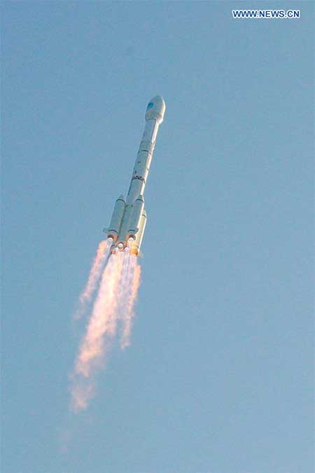
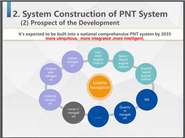
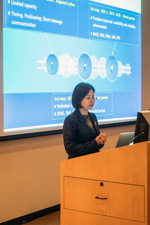
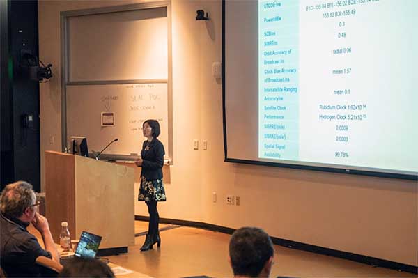
    Furchtgott-Roth’s comments came roughly a month after a Chinese representative to a Stanford symposium that here nation was developing a national “comprehensive PNT” after the fashion of what was called for in the U.S.’s 2008 study.

    Her prepared remarks are available here.

  • World-renowned PNT expert David Last presumed lost at sea

    World-renowned PNT expert David Last presumed lost at sea

    UPDATE: The search was called off on Tuesday afternoon. Additional information is available in this Evening Standard article.


    David Last (Photo: @harriethallphoto via Dana Goward)
    David Last (Photo: @harriethallphoto via Dana Goward)

    Just before 13:00 GMT on Nov. 25, a private plane piloted by David Last, former president of the Royal Institute of Navigation, disappeared from radar and hit the sea approximately two miles off the coast of Wales.

    On-going search and rescue efforts have recovered pieces of wreckage and personal effects.

    “Last was one of the most respected and well-loved figures in the worldwide positioning, navigation, and timing community. His loss creates a hole that cannot be filled,” said Dana Goward, president of the Resilient Navigation and Timing Foundation. “David was a close personal friend. Our grieving will not be brief.”

    According to BBC News, the search for the missing plane and its pilot off the Welsh coast resumed on Nov. 26. North Wales Police said the light aircraft was flying from Caernarfon Airport to the Great Orme, Llandudno, and back on Monday when it disappeared. There were no other passengers and officers were supporting the missing pilot’s family.

    The Maritime and Coastguard Agency said the search has resumed around Puffin Island, near Penmon, Anglesey. A plane carrying a sonar technology camera is searching the area as well as a lifeboat, helicopter and coastguard teams on foot.

    David Last was a U.K. consultant engineer specializing in radio navigation and communications systems, professor emeritus at the University of Bangor, Wales, and past president of the Royal Institute of Navigation.

    He also was a member of the expert panel and co-author of the January 2018 Blackett Report.

  • China launches two MEO BeiDou-3 satellites

    China launches two MEO BeiDou-3 satellites

    China sends two BeiDou satellites into space a Nov. 23. (Photo: Guo Wenbin/Xinhua)
    China sends two BeiDou satellites into space a Nov. 23. (Photo: Guo Wenbin/Xinhua)

    China launched two satellites of the BeiDou Navigation Satellite System (BDS) into space from the Xichang Satellite Launch Center in Sichuan Province at 8:55 a.m. Saturday, Nov. 23.

    Launched on a Long March-3B carrier rocket and the Yuanzheng-1 (Expedition-1) upper stage attached to the carrier rocket, the two satellites have entered their planned orbits. They are the 50th and 51st satellites of the BDS satellite family.

    The two medium earth orbit (MEO) satellites are also network satellites of the BeiDou-3 system.

    The two new satellites, the carrier rocket and Yuanzheng-1 were all developed by the Innovation Academy for Microsatellites of the Chinese Academy of Sciences and the China Academy of Launch Vehicle Technology under the China Aerospace Science and Technology Corporation.

    The launch was the 319th mission for the Long March series carrier rockets.

  • U.S. Air Force to put NTS-3 into geostationary orbit

    U.S. Air Force to put NTS-3 into geostationary orbit

    History of the program: NTS-1, 2 and 3. (Illustration: Lt. Jacob Lutz, AFRL Space Vehicles Directorate)
    Satellites NTS-1, 2 and 3. (Illustration: Lt. Jacob Lutz, AFRL Space Vehicles Directorate)

    The Air Force seems to be on track to experiment with positioning, navigation and timing (PNT) satellites in geostationary orbit.

    The idea for Navigation Technology Satellite 3 (NTS-3) has been around for a while, and notionally scheduled for launch in 2023.

    Recently, the Air Force announced it will engage in the Vanguard science and technology program to quickly bring capabilities to the service. It is unclear whether or not this will ensure the 2023 launch takes place, or if the program will be accelerated for an earlier launch.

    NTS-3 will include:

    • Experimental antennas
    • Flexible and secure signals
    • Increased automation
    • Use of commercial assets
    • A new digital signal generator that can be reprogrammed on-orbit, enabling it to broadcast new signals
    • Digital signatures for detecting spoofing attacks
    • Steerable regional beams in multiple frequencies and signal codes
    • “Bounce-Back” capabilities for recovery from attack, solar and other disruptions

    The NTS-3 marks the first time in 40 years the service has launched such a pioneering effort, following GPS.

    The Department of Defense PNT Strategy calls for future military efforts and the results to be classified, making it unlikely that NTS-3 experiments will benefit the majority of PNT users in the civil sector.

    NTS-3 Fact Sheet from ARFL.

  • GSA announces 2019 winners of MyGalileoApp competition

    GSA announces 2019 winners of MyGalileoApp competition

    First place winners ARGEO accept their prize. (Photo: GSA)
    First place winners ARGEO accept their prize. (Photo: GSA)

    News from the European GNSS Agency

    The winners of this year’s MyGalileoApp competition were announced at a ceremony held at the European GNSS Agency (GSA) headquarters in Prague on Nov. 7.

    First prize of EUR 100,000 went to ARGEO, a mobile app based on geolocation, augmented reality and blockchain that allows users to discover content such as prizes, coupons and shopping cards geo-located around the streets of a city.

    Second prize, worth EUR 50,000, went to the Tractor Navigator app, which provides guidance for farmers driving tractors, enabling them to visualise their position and trajectory in an open field. Finally, the EUR 30,000 third prize went to Ready Park, an app that makes parking easier by pairing drivers leaving a spot with users looking for one.

    The 10 finalists from eight countries made their pitches to a panel of jurors throughout the afternoon of Nov. 7, after which the jury reached its decision on the winning apps.

    Welcoming the competitors to the finals, GSA Executive Director Carlo des Dorides noted that the 10 finalists had been selected from a total of 150 competing teams, representing more than 35 nationalities.

    “The MyGalileoApp competition is the largest app development competition ever organised within the Galileo programme. After reaching 1 billion smartphones equipped with Galileo earlier this year, the next big challenge is to develop applications that will make best use of the Galileo differentiators,” des Dorides said.

    Following the pitches was an investors’ panel, with presentations by experts from various institutions, including venture capital firms and accelerators, providing information on how apps can bridge the gap between great ideas and viable business opportunities.

    “Private and public investors will have an opportunity today to expand their investment portfolio with the Galileo apps generated by the competition, helping to transform the apps into commercial successes,” des Dorides said, adding that the goal of the MyGalileoApp competition was not just to make beautiful apps, but to create jobs and generate economic growth. For a full agenda of the day’s events, click here.

  • China leads world with plan for ‘comprehensive’ PNT

    China leads world with plan for ‘comprehensive’ PNT

    Speaking at the annual Stanford Positioning, Navigation, and Timing (PNT) Symposium, a Chinese representative described how her nation is building the world’s first resilient and robust, and, in her words, “comprehensive” PNT architecture.

    Xiaochun Lu presents at Stanford PNT Symposium on Oct. 30, 2019. (Photo: Stanford University)
    Xiaochun Lu presents at Stanford PNT Symposium on Oct. 30, 2019. (Photo: Stanford University)

    Xiaochun Lu of China’s National Timing Service Center described a multi-source PNT system that will be “more ubiquitous, more integrated, more intelligent.”

    Centered around continually upgraded BeiDou GNSS at medium earth orbit (MEO), it will incorporate a wide variety of other PNT sources. These will include a PNT constellation at low earth orbit (LEO), Loran-C, inertial sensors, and systems like quantum navigation that have yet to be developed.

    A new PNT constellation at LEO was mentioned several times in the presentation according to Rich Lee, CEO of iPosi, who attended the symposium. Lee has advocated the benefits of LEO PNT and suggested the U.S. should pursue such a system to augment GPS.

    Research has shown that received signals from PNT constellations at LEO will be stronger and more difficult to disrupt than those from MEO. When combined with MEO PNT signals, they will also enable much more precise positioning.

    In discussions after her presentation, Lu indicated that China has an application pending at the ITU for 120 LEO PNT satellites flying at 700 km.

    Also noteworthy was inclusion in the architecture of China’s existing Loran-C terrestrial PNT system. China has operated this system for decades and regularly coordinates its integrated use with Russian and South Korean systems as part of the Far East Radio Navigation Service (FERNS).

    Xiaochun Lu discusses China’s Comprehensive PNT Plan with Rich Lee of iPosi and Logan Scott of Logan Scott Consulting at 2019 Stanford PNT Symposium. (Photo: Stanford University)
    Xiaochun Lu discusses China’s Comprehensive PNT Plan with Rich Lee of iPosi and Logan Scott of Logan Scott Consulting at 2019 Stanford PNT Symposium. (Photo: Stanford University)

    The United States terminated Loran-C service in 2010 over the objection of its national PNT advisory board. Europe’s Loran system was taken off the air at the end of 2015. This was despite the United Kingdom’s implementation of a more accurate and automated eLoran version at the beginning of that year.

    Today the United States is in the process of establishing a terrestrial backup system for GPS timing that could be expanded to include positioning and navigation services.

    Europe has acknowledged that GNSS alone is insufficient for critical and safety of life applications. Officials are examining what that means in terms of systems required.

    China”s announcement at Stanford is the first for a plan to build a comprehensive national PNT architecture.

    Graphic: Xiaochun Lu, China National Timing Center
    Graphic: Xiaochun Lu, China National Timing Center

    Both Europe and the United States have published radionavigation plans, though these tend to be more descriptions of current systems than forward looking and actionable plans.

    The United States published a “National Positioning, Navigation, and Timing Architecture Study” in 2008. Little action was ever taken to implement its recommendations. A graphic from this document was included in Lu’s Stanford presentation indicating that the U.S. study may have helped inspire and motivate China’s plan.

    Xiaochun Lu presents at Stanford PNT Symposium on Oct. 30, 2019. (Photo: Stanford University)
    Xiaochun Lu presents at Stanford PNT Symposium on Oct. 30, 2019. (Photo: Stanford University)

    In August 2019, the U.S. Department of Defense publicly released its PNT strategy. It is similar in many ways to the Chinese plan described by Lu, calling for the use of multiple and diverse sources of PNT. As part of this, Army Futures Command is working with the University of Texas to leverage for PNT thousands of yet-to-be-built communications satellites planned to be deployed at LEO.

    U.S. military PNT efforts, though, are unlikely to help protect the American populace. The defense department strategy says that civil use of GPS has hindered the ability to leverage it for military purposes. Future U.S. military PNT systems will be “increasingly classified” and therefore not available for civil use.

  • CGSIC meeting material available for download

    CGSIC meeting material available for download

    CGSIC logo

    By Rick Hamilton, CGSIC Executive Secretariat, U.S. Coast Guard Navigation Center

    The 59th meeting of the U.S. Civil GPS Service Interface Committee was held Sept. 16-17 at the Hyatt Regency Miami hotel in Miami, Florida, in conjunction with the Institute of Navigation’s GNSS+ (ION-GNSS+) conference.

    For readers who were unable to attend, a synopsis of the meeting is provided below. The full agenda and presentations are available for download from the GPS.gov website.

    The meeting of the CGSIC is an annual event, free and open to the public, conducted to provide updates from U.S. GPS program officials and ensure effective information exchange between the U.S. government and civil GPS users.

    The two-day meeting is hosted by the U.S. Department of Transportation (DOT) and the Coast Guard Navigation Center (NAVCEN). DOT serves as the civil lead for GPS and chairs the CGSIC in this capacity. NAVCEN is assigned duties as Deputy Chair and Executive Secretariat for the CGSIC.

    Engaging sessions were conducted throughout the day of Sept. 16 for the CGSIC Timing, Surveying Mapping and Geo-Sciences, and International Information Subcommittees. The plenary session of the full committee was held on Sept. 17.

    Keynote. Diana Furchtgott-Roth, deputy assistant secretary, Office of the Assistant Secretary for Research and Technology, U.S. Department of Transportation provided the keynote for this year’s plenary session.

    She conveyed to the audience the importance of the U.S. GPS for transportation safety and numerous other civil applications and that its spectrum must be protected from harmful interference.

    However, given threats from jamming and spoofing, the U.S. is committed to leading the world in positioning, navigation and timing (PNT) and to building and using the best possible PNT solutions to maintain resiliency.

    James Platt, director at the PNT Program Management Office of the U.S. Department of Homeland Security, highlighted the need to understand cyber vulnerabilities in critical infrastructure supply-chain management.

    The meeting included many other interesting briefings related to the status of the U.S. GPS program and the use of GPS around the world, including presentations from the National Space-Based PNT Coordination Office, U.S. Air Force, State Dept., FAA, DOC and NASA.

    Presentations during the plenary session focused on the operational status of the GPS constellation and ground control system modernization, U.S. Space-Based PNT policy, GPS augmentation systems, U.S. engagement with other international GNSS providers, as well as a variety of topics related to the status and progress of ongoing GPS programs in the U.S. government.

    If you have suggestions for topics to include in upcoming CGSIC meetings, would like to present a topic, or if you found information from past meetings useful and would like to hear more, contact Hamilton via the Navigation Center “contact us” form. Be sure to select “Civil GPS Service Interface Committee (CGSIC)” from the pull-down menu.

    From a GPS operational perspective, civilian non-aviation users can submit GPS-related inquiries or report signal interference or degradation to the U.S. Coast Guard Navigation Center online or to the 24 hour watch desk at 703-313-5900.

    Civil aviation users within the United States should contact the Federal Aviation Administration for GPS user support. The GPS Operations Center at Schriever Air Force Base, Colorado, is the lead in the Department of Defense for operational issues and questions from military users of GPS.

  • Webinar talks GNSS final frontier — space

    A free GPS World webinar on Nov. 21 tackles a new frontier, if not the final one, for GNSS. “Developments in Space GNSS Navigation,” sponsored by NovAtel, brings together experts from NASA, ESA, NovAtel and Spire (the CubeSat company) to discuss how they’re taking GNSS capabilities beyond Earth’s boundaries.

    Navigating through space has long proven to be challenge for aerospace engineers and professionals because of the complex combination of technology and cost required for success.

    However, with advancements in GNSS and receiver technology, organizations and nations around the world are increasingly interested in space exploration activities.

    Today, the space industry is seeing GNSS technology used in low-Earth orbit (LEO) and highly elliptical orbit scenarios.

    In this webinar, speakers from NASA, ESA (the European Space Agency), NovAtel and Spire will examine emerging trends regarding the usage of GNSS technology in the space industry, including an increasing need for situational awareness while navigating through space and the ability to service satellites while in orbit.

    These experts will also provide a look into their own experiences with a variety of ambitious space projects and applications.

    Speakers include:

    • Werner Enderle, Head of Navigation Support Office, ESA European Space Operations Center
    • Benjamin Ashman, Aerospace Engineer, NASA
    • Erin Kahr, Critical Safety Systems, NovAtel
    • Dallas Masters, GNSS Program Manager, Spire

    Date: Thursday, November 21, 2019
    Time: 1 p.m. EST / 10 a.m. PST / 7 p.m. (1900h) Central European Time

    Learn details of the webinar, or register for free.

  • China launches a new BDS-3 satellite

    China launches a new BDS-3 satellite

    China sent a new satellite of the BeiDou Navigation Satellite System (BDS) into space from the Xichang Satellite Launch Center in Sichuan Province at 17:43:04.482 UTC on Nov. 5.

    Launched on a Long March-3B carrier rocket, it is the 49th satellite of the BDS satellite family and the 24th satellite of the BDS-3 system.

    It also marked that a total of three BDS-3 satellites have been sent into the inclined geosynchronous Earth orbit.

    The launch was the 317th mission for the Long March series of carrier rockets.

    The new satellites and the carrier rocket were developed by the China Academy of Space Technology and the China Academy of Launch Vehicle Technology, under the China Aerospace Science and Technology Corporation.

    China will launch another six BDS-3 satellites to complete the BDS global network.

    A new BeiDou satellite is launched from the Xichang Satellite Launch Center in southwest China's Sichuan Province on Nov. 5. (Photo: Liu Xu/Xinhua)
    A new BeiDou satellite is launched from the Xichang Satellite Launch Center in southwest China’s Sichuan Province on Nov. 5. (Photo: Liu Xu/Xinhua)
  • “Unacceptable! Never again!”: EC Deputy on Galileo outage

    “Unacceptable! Never again!”: EC Deputy on Galileo outage

    Pierre Delsaux speaks at an EU breakfast on space policy . (Photo: European Union)
    Pierre Delsaux speaks at an EU breakfast on space policy . (Photo: European Union)

    Responding to a suggestion about the Galileo outage this past summer to the effect of “these things happen,” a senior European Commission (EC) official pushed back strongly, calling the event “Unacceptable!” and vowing “Never again!”

    The comments by Pierre Delsaux came during a question-and-answer session at breakfast hosted by the European Union on “EU Space Policy: Trends for the Future.” The breakfast was held as a parallel event to this year’s International Astronautics Conference in Washington, D.C.

    Delsaux is the European Commission Deputy Director General in charge of space and defense industries. In his presentation, Delsaux described the success of a number of European space initiatives, stressing civilian use and applications and how they have benefited the world.

    His comments highlighted a principle difference between Galileo and other GNSS systems including its being built and operated by an entirely civilian organization. With an accuracy of 20 centimeters, it exceeds other GNSS, he said. Also, that Galileo signals can be authenticated and trusted.

    Delsaux’s remarks were especially pertinent and timely being made this week in the United States. A strategy document recently made public by the U.S. Department of Defense states that civil dependence on GPS has limited its use as a military tool. Because of this, new military PNT technologies will be “increasingly classified,” which is understood to mean “not shared with civil users.”

    During the question-and-answer period, Delsaux was asked about criticism in the press this summer related to Galileo’s multi-day outage. European media outlets commented about poor communications and a lack of transparency during the outage, and the absence of a terrestrial backup system for when space is not available.

    Rejecting the idea that such outages might be expected in such a difficult undertaking, Delsaux said that the event was unacceptable and “never again!”

    While admitting things can always be done better, he thought that, given what was known with certainty at the time, a reasonable amount of information was made available.

    Subsequent investigation has shown that the primary cause was an initial human error compounded by that person not taking the right corrective action.

    Even with these compounded errors Galileo service would still not had been impacted, but for the mischance that this happened when a backup site was temporarily out of service.

    Going forward, the European Commission is committed to being as transparent as possible about the results of the investigation, given security constraints.

    Reinforcing the transparency message, other EC officials mentioned separately that Galileo personnel had given presentations about the outage at a recent Institute of Navigation Conference in Miami.

    Delsaux did not respond to press criticism over a lack of a backup system (the title of a Der Spiegel article about the Galileo failure translates as “Who relies on a single system is stupid!”).

    Later, other EC officials observed that that the European Radionavigation Plan recognizes that for critical applications, it is broadly accepted that GNSS, even multi-constellation and multifrequency, should not be the unique source of PNT information. For those applications, a complementary, alternative or backup solution should be maintained or developed.

    The EC is still developing its approach to this issue.

  • Raytheon upgrades WAAS with GEO 6 payload

    Raytheon upgrades WAAS with GEO 6 payload

    Photo: Nieuwland Photography/Shutterstock
    Photo: Nieuwland Photography/Shutterstock

    Raytheon has delivered the Wide Area Augmentation System Geosynchronous Earth Orbiting 6 satellite navigation payload to the U.S. Federal Aviation Administration (FAA) to broadcast the WAAS message, which corrects errors in GPS satellite signals, provides expanded coverage, improves accuracy and increases reliability.

    The WAAS GEO 6 payload is now operational and fully integrated into the WAAS network, working with two other WAAS satellite payloads already in orbit.

    The SES-15 satellite hosting Raytheon’s WAAS GEO 6 payload was launched in 2017 and completed extensive system integration in July 2019.

    GEO 6 replaces an older WAAS geostationary satellite that had reached its end-of-service life.

    About WAAS. Developed and installed by Raytheon for the FAA, WAAS is a North American satellite-based augmentation system that increases GPS satellite signal accuracy for precision approach at 200 feet altitude to meet strict air navigation performance and safety requirements for all classes of aircraft in all phases of flight.

    WAAS contains space and ground equipment that works together to identify GPS satellite corrections.

    Operational since 2003, the WAAS network consists of three geostationary satellites and 49 terrestrial-based stations dispersed across the continental U.S., as well as Alaska, Canada, Hawaii, Puerto Rico and Mexico.

    “Never has a consistent and precise GPS signal been more critical to ensuring safety of flight,” said Matt Gilligan, vice president of Raytheon’s Intelligence, Information and Services business. “As the airspace increases in complexity, there is absolutely no room for error.”

    To learn more about Raytheon’s portfolio of air traffic management solutions, visit here.

  • ESA to use CORS networks for global error mapping

    ESA to use CORS networks for global error mapping

    News from the European Space Agency

    There are more than five billion satnav devices on Earth. Along with smartphones and mobile receivers, this figure includes networks of fixed receiver stations, used to improve accuracy. An ESA-led project will harness these networks to provide an ongoing overview of satnav performance from the global to national and regional scale.

    <b>CORS station:</b> The CORS network is a multi-purpose cooperative endeavor involving government, academic and private organizations. The sites are independently owned and operated. Each agency shares its data with NGS, and NGS in turn analyzes and distributes the data free of charge. (Photo: NOAA)
    CORS station: The CORS network is a multi-purpose cooperative endeavor involving government, academic and private organizations. The sites are independently owned and operated. Each agency shares its data with NGS, and NGS in turn analyzes and distributes the data free of charge. (Photo: NOAA)

    “The general assumption is that Global Navigation Satellite System (GNSS) services can always be relied on, which is true 99% of the time,” commented Michael Pattinson of Nottingham Scientific Ltd. in the United Kingdom, which is developing this new project for ESA.

    “That’s fine for the ordinary smartphone user, but for safety-critical applications, in particular, we need to know exactly when systems are not performing optimally, and why.

    “Current performance monitoring is often partial, based around individual signal frequencies or constellations, carried out by the service operators themselves. With our new COLOSSUS — Crowd-Sourced Platform for GNSS Anomaly Identification, Isolation and Attribution Analysis — data platform, we’ll be creating the most detailed possible picture of overall performance from the user side, covering all satellite constellations, signal frequencies and receiver types.

    OS Net Station: A CORS station in Tiree, the Hebrides, part of the Ordnance Survey's 110-strong OS Net network. (Photo: ESA)
    OS Net Station: A CORS station in Tiree, the Hebrides, part of the Ordnance Survey’s 110-strong OS Net network. (Photo: Ordnance Survey)

    “The aim is to immediately identify system failures, faults and other errors on an immediate, autonomous basis. And we’ll do this by harnessing a resource that is already out there: gathering and analysing positioning data from networks of ‘continuously operating receiver stations’, known as CORS for short.”

    There are many hundreds of these CORS stations across the globe. By performing positioning continuously at a fixed site in the landscape, they can be used as a standard, serving to identify and subtract measurement errors to boost positioning accuracy on a localised basis.

    Many CORS networks have been established for scientific uses, such as the worldwide International GNSS Station (IGS) network, used as a standard geographical reference and to measure shifts in the solid Earth, oceans and ice.

    Others have been set up by national mapping agencies, such as the Ordnance Survey in the UK. There are also private-sector networks, employed for improving the accuracy of services such as land surveying, air service providers, road charging or driverless cars.

    IGS Global Network: the worldwide International GNSS Station (IGS) network of CORS stations is used as a standard geographical reference and to measure shifts in the solid Earth, oceans and ice.(Image: ESA)
    IGS Global Network: the worldwide International GNSS Station (IGS) network of CORS stations is used as a standard geographical reference and to measure shifts in the solid Earth, oceans and ice.(Image: ESA)

    “Each network is different,” added Pattinson. “Some make their data freely available, others involve registering or payment. We’re talking to operators to allow us to access their data in exchange for sharing our results, and they’re very interested in accessing such performance metrics.

    “With measurements from so many sites, when a failure does occur we’ll be able to pin down its likely source almost immediately. Is it localised interference, or does it have a wider impact? Is it atmospheric disturbance? Is only a single model of GNSS receiver affected, or multiple types? Is it a problem with a single satellite, multiple satellites or even multiple constellations?”

    The company is also deploying its own CORS receivers as an additional data source, at the same time as it develops and tests its processing algorithms. The aim is to begin testing the cloud-based COLOSSUS towards the end of 2019 and bring the service online in the first few months of 2020.

    “Once the service starts, it will run continuously, just like the CORS stations themselves,” Pattinson said. “Our goal is for COLOSSUS to become a key player in GNSS performance monitoring, building up a database of all anomalies that occur and their consequences in terms of constellations, geographical regions and receiver types, to give users, service providers, and regulators an informed sense of how much ‘trust’ to place in these systems.”

    This project is supported through ESA’s Navigation Innovation and Support Programme, NAVISP, applying ESA’s hard-won expertise from Galileo and Europe’s EGNOS satellite augmentation system to new satellite navigation and — more widely — positioning, navigation and timing challenges.