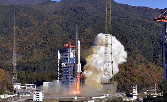
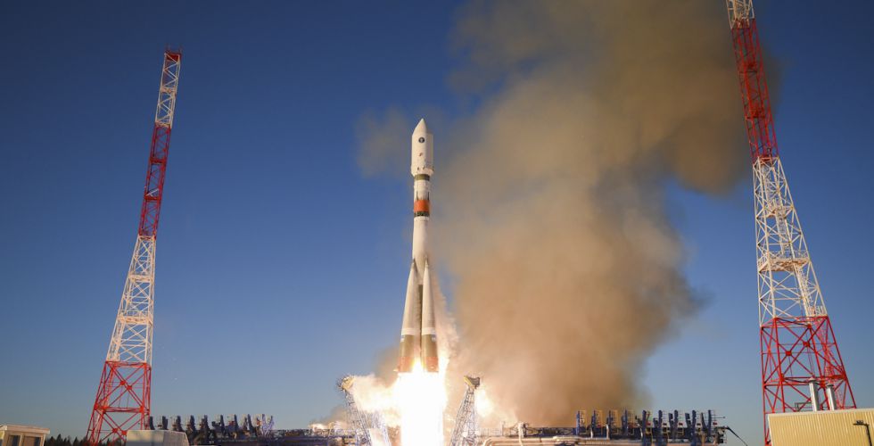
China successfully sent two satellites of the BeiDou Navigation Satellite System (BDS) into space from Xichang Satellite Launch Center in Sichuan Province at 15:22 on Dec. 16.
So far, 24 medium earth orbit (MEO) BDS-3 satellites have been successfully sent into space, and the deployment of the core BDS-3 constellation system has been completed, according to Yang Changfeng, chief designer of the BDS.
Launched on a Long March-3A carrier rocket, the two satellites entered preset orbit after a more than three hours of flight, according to XinhuaNet, China’s official news service.
The launch was the 321st mission for the Long March series carrier rockets and the 108th mission for the Long March-3A carrier rocket.
In June, China stated its plan to complete the BDS-3 constellation by 2020.
Yury Urlichich, First Deputy Director General, Roscosmos. (Photo: Roscosmos)
By Yury Urlichich, First Deputy Director General of ROSCOMOS State Space Corporation Sergey Karutin, Designer General of GLONASS Nikolay Testoedov, Director General, Information Satellite Systems
Roscosmos keeps concentrating on user needs as it did in previous years. Growing digitalization is driving a high demand for high-accuracy navigation services. Space information technologies support user needs by modern digital services, including increasing accuracy of position and velocity determination. Because of this, it is of vital importance for us to ensure that GLONASS provides continuous services and stable performance.
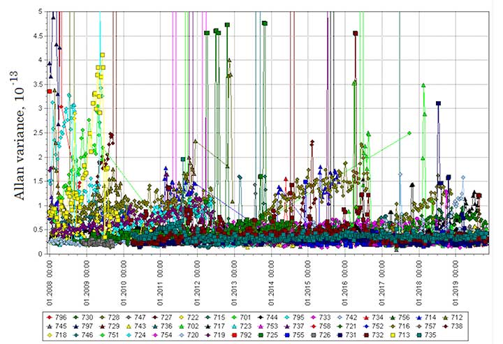
Figure 1. Mature Glonass-M satellites show improved cesium frequency standards performance in terms of daily stability. (Image: Roscosmos)
Performance Standard & ICD
This year, we finished drafting the GLONASS Open Service Performance Standard (GLONASS OS PS; the Russian language version is available). In 2020, the new version of the GLONASS Interface Control Document (ICD) also will be publicly available.
GLONASS OS PS serves as a high-level mainframe document specifying the values of the achieved GLONASS performance characteristics plus the significant guaranteed margin. These, coupled with the signal reception environment and a priori estimation of user equipment performance characteristics, can further be translated into the performance that an end user can expect to achieve in his specific PVT solution.
This GLONASS OS PS is a basis for certification of GLONASS services and development of lower level standards for user receiver and GLONASS-based service, as well as for development of international standards like those of the International Civil Aviation Organization (ICAO), the International Maritime Organization (IMO) and others.
Use of the unified set of performance parameters and calculation methods for all GNSS — GLONASS, GPS, Galileo and BDS — is a conventional practice. The similar standards for GPS, Galileo and BDS have been published and are regularly updated.
In fact, this GLONASS OS PS is the second one after the ICD baseline interface between GLONASS and user receiver manufacturers and the GLONASS-based services developers. The OS PS establishes the minimum performance that can be achieved by users with a high level of trust based on the system’s long-term statistical history.
Signal-in-Space. This OS PS specifies standards for the GLONASS OS Signal-in-Space (SIS) performance neglecting receiver biases, signal propagation and reception biases (in terms of performance metrics used to specify system performance, that is, taking into account the GLONASS space segment and the GLONASS ground segment contributions to the performance). It can serve as a basis for certification of the GLONASS-based services and receivers incorporating GLONASS, including those used in aviation and other user domains.
The OS PS provides an overview of the GLONASS system and an overview of the GLONASS Open Service SIS. It specifies the standards for the performance characteristics of the channel of standard accuracy used to provide the Open Service, and lists the legal reference documents.
L3 CDMA. One of the most significant tasks is the harmonization of GLONASS user interfaces with respect to new L3 CDMA signals. The requirements related to the interface between the space segment of GLONASS and the navigation user segment for radio frequency links is established by the GLONASS ICDs.
The new version of ICD for CDMA L1, L2 and L3 signals to be broadcast by new-generation Glonass-K2 satellites was issued in 2016. However, the Glonass-M satellites (## 755-758) and the Glonass-K satellites currently in orbit transmit the L3 signal as per the L3 Open Access CDMA Radionavigation Signal Interface Control Document (Edition 1) of 2011.
In order to mitigate the above-mentioned discrepancies, five reference documents (Interface Control Documents for open-access signals) have been updated and prepared for publication. In addition, flight tests to verify new ionospheric and tropospheric delay models have been scheduled.
Incorporating More Data
The new ICDs for open access and authorized signals incorporate changes related to the introduction of additional data into the spare bits of the navigation message. This additional data is to be used by user receivers for better PVT solution purposes.
The updated versions of ICDs will incorporate:
The mathematical ionospheric delay model and inclusion of the model parameter into the navigation message.
The mathematical tropospheric delay model, which does not require that any specific parameters be included into the navigation message. It only employs data on the latitude of a user receiver location and the season (i.e., winter, spring, summer, and autumn).
The attribute (or flag) to inform a user that a satellite is in the turn mode and its antenna phase center behavior is different from that when a satellite is in the sun orientation mode.
Information about the types of signals broadcast on the L1, L2, and L3 frequencies; 5-bit field, in which the first three bits denote L1, L2, and L3 CDMA signals, respectively, while the 4th and the 5th bits denote L1 and L2 FDMA signals, respectively.
A 5-bit field to be used to broadcast age of data (AOD) for time offsets in addition to the similar field used to broadcast AOD for ephemerides.
Backward Compatibility. The updated CDMA and FDMA ICDs will support the backward compatibility for the uninterrupted operation of the existing envelope of user equipment and the introduction of the ionospheric and tropospheric model parameters into the message spare capacity.
Constellation Refresh
The GLONASS constellation has been replenished steadily. Since 2013, we have been launching one to two satellites a year, and this year is not an exception. The launch on May 27 and the December launch will help sustain the nominal constellation. The Glonass-M satellites demonstrate good dynamics for the average operational life. Two satellites are well beyond their 10-year design life — their operational lifetime has exceeded 12 years. As some of the Glonass-M satellites grow older, their cesium frequency standards performance in terms of daily stability improves (see Figure 1).
Glonass-K. In 2020, the launch campaign for the Glonass-M satellites will come to its end. The Glonass-K satellites will come on stage with the first launch of Glonass-K-15 scheduled for the beginning of the next year. We are fully confident that this satellite will not disappoint our users.
By Javier Benedicto
Head, Galileo Programme department,
European Space Agency
Javier Benedicto, left, accept the 2018 GPS World Satellites Leadership Award on behalf of Giuliano Gatti of the European Space Agency, from Phil Froom of Rockwell Collins. (Photo: Melanie Beus)
Since the Galileo initial services declaration in December 2016, the Galileo Program has been providing global PNT and search-and-rescue services for users worldwide. The European GNSS Agency (GSA) just issued its GNSS 2019 Market Report in October, providing a complete overview of the current status and trends of the GNSS worldwide market with focus on European GNSS (Galileo and EGNOS) applications and services.
In parallel with service provision, the Galileo Program is undertaking extensive infrastructure development and deployment activities to reach Full Operational Capability (FOC), incorporating new service capabilities, but above all aiming at increasing the robustness and resilience of the system infrastructure, operations and service provision.
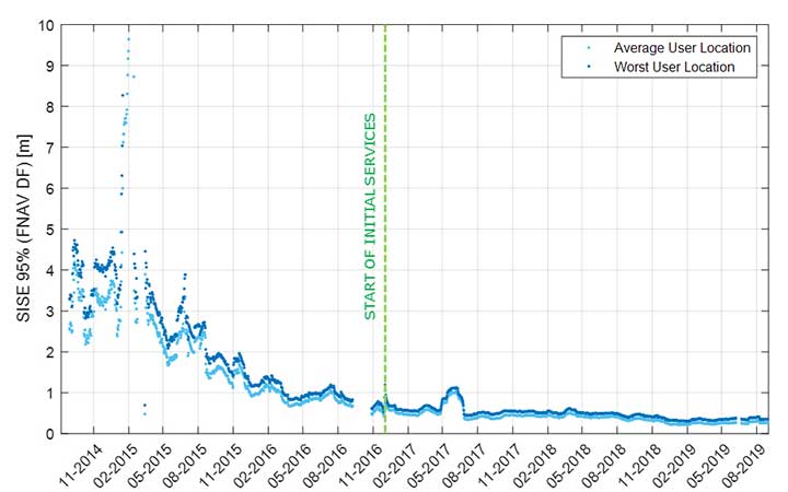
Galileo’s signal-in-space quality has steadily improved over the past few years, reaching in 2019 a best signal-in-space error (SISE) of about 0.25 meters (95%, global average; Figure 1). This has been achieved through a combination of several factors, including the increased number of operational satellites, enhanced versions of the Ground Mission Segment, and higher uplink rate of the navigation message (lower age of data). This performance is well within Galileo’s initial service accuracy commitments, as defined in the public Open Service – Service Definition Document (OS SDD).
Figure 1. Long-term historical SISE plot over a 30-day sliding window, constellation averaged. (Image: ESA)
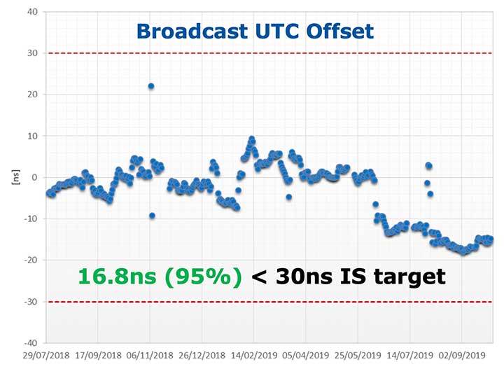
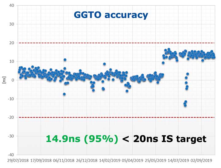
Figures 2 and 3 (see page 40) show Galileo’s timing performance as broadcast UTC offset and GGTO accuracy. The evaluation was performed with calibrated GPS/Galileo timing receivers operated in UTC(k) laboratory (PTB, INRIM). Again, the initial timing service commitments have been fully met.
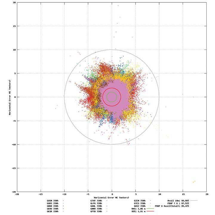
Probably the most significant discriminator of Galileo compared to other GNSS is its capability to broadcast multi-frequency (E1, E6, E5) signal components on all operational satellites. The position performance of a dual-frequency user receiver on-ground is shown in Figure 4. This measurement from June 2019 demonstrates a Galileo position accuracy well below 2 m (95%).
Figure 4. Galileo position accuracy performance, dual-frequency, June 2019. (Image: ESA)
With the aim of further improving the Open Service (OS) performance, three newly introduced I/NAV message improvements on Galileo E1-B are under implementation, namely FEC2 Reed-Solomon Clock and Ephemeris (CED), Reduced CED, and Secondary Synchronization Pattern (SSP). Galileo Open Service (OS) users will benefit from improved robustness in terms of navigation data retrieval in challenging environments, in addition to facilitating a reduced time to first fix. Those I/NAV improvements on Galileo E1-B are backwards compatible with previously released OS SIS ICDs.
In addition, Galileo infrastructure is currently being upgraded to provide means for OS authentication. The protocol proposed uses the E1B External Data Broadcast Service (EDBS) to provide authentication data to the user. The OS Navigation Message Authentication (NMA) is based on an adaptation of the Timed Efficient Stream Loss-tolerant Authentication (TESLA) protocol.
Beyond the OS, the Galileo system has been designed to allow for the dissemination of value-added data, such as high accuracy and authentication, in the E6B signal component. The component has been designed to broadcast the Galileo High Accuracy Service based on the provision of accurate satellite data (clocks, orbits and biases) and atmospheric data (mainly ionospheric corrections) to enable multi-frequency multi-constellation PPP with correction data transmitted through an open format in the Galileo E6B signal.
The introduction in early 2020 of the automatic acknowledgment of the SAR/Galileo Return Link Message (RLM) as part of the Cospas-Sarsat system will enable space assets to be used for search and rescue — persons in distress will get swift acknowledgement that their alert has been detected and located. The Return Link is the means to interact with a SAR beacon, improving the effectiveness of SAR operations. Extensive testing has demonstrated that the median latency for the reception of a return link message on the ground is 14.2 seconds, while 99% of messages are received within 57 seconds, after the request for the RLM transmission is delivered to Galileo (from Cospas-Sarsat to the RLSP). At the same time, the measured rate of reception was 100%, considering line-of-sight availability, thanks to the very robust Galileo navigation data link. This performance has been demonstrated to be uniform across the globe, as shown in Figure 5.
Figure 5. Beacon activation map and RLM delivery latency through the Galileo system. (Image: ESA)
Following the re-profiling of the Galileo Safety-of-Life (SoL) service, Galileo is meant to be exploited through dual-frequency multi-constellation (DFMC) SBAS and will support the provision of integrity through the concept of Horizontal Advanced Receiver Autonomous Integrity Monitoring (H-ARAIM). To allow the exploitation of Galileo for these SoL applications, a thorough analysis of the actual signal-in-space (SiS) performance and of potential feared events critical for SoL users is key. In this context, the Galileo Integrity Failure Mode and Effect Analysis (IFMEA) process is implemented through measurements and review of the system design, including feared-events characterization.
Ground Segment Brings Robustness
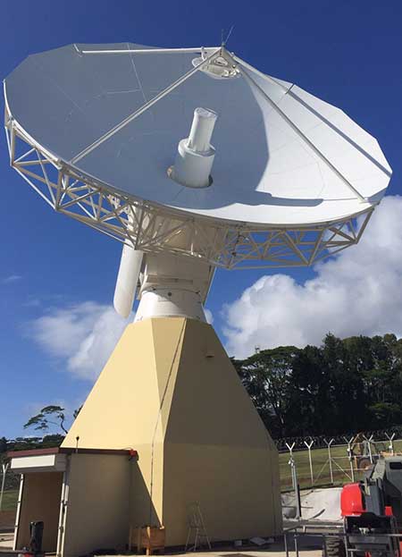
Galileo telemetry and telecommand ground station. (Photo: ESA)
Galileo’s Ground Segment is being upgraded to fully redundant control centers. These include processing and storage, monitoring and control facilities, and security monitoring centers. A worldwide network of Galileo Sensor Stations (GSS) allows monitoring and measuring of satellite signals; uplink stations allow dissemination of the navigation message to users through Galileo satellites; and telemetry, tracking and control (TTC) stations allow monitoring and control of the satellites.
Ground segment upgrades under production by Thales Alenia Space France (in charge of the ground mission segment and security monitoring) and GMV Spain (in charge of the ground control segment) are addressing increased service robustness, through the introduction of a more flexible infrastructure with a significant technology refresh, improved security, service continuity, enhanced service performances, and enhanced operability features.
One important objective of the ongoing upgrades is to implement a modern infrastructure, based on leading virtualization technologies. This modernized infrastructure will make it possible to easily accommodate hardware and software changes without requiring significant redesign or requalification, and will minimize the impact to Galileo service operations — under responsibility of Spaceopal GmbH — during future deployment activities.
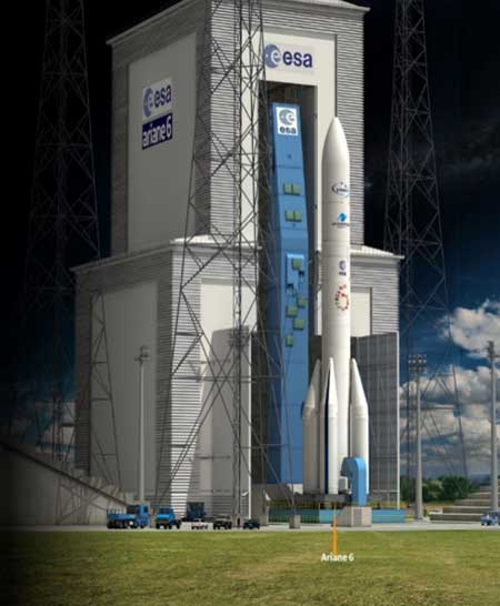
Batch 3, Ariane 6 Under Production
Ariane 6 on the launchpad. (Artist’s concept: ESA)
The production of Batch 3 of 12 additional Galileo FOC satellites is proceeding, aiming at readiness for launch by the end of 2020 onward. The satellite design includes a selected number of improvements compared to the 22 FOC satellites launched previously and built by the same satellite manufacturer OHB Systems.
The different stages of assembly, integration and initial test phase in the OHB production plant in Bremen have already started, before shipment to ESA-ESTEC in the Netherlands for the environmental test campaign consisting of thermal vacuum, mechanical tests, interface verification with the launcher and system end-to-end performance tests with the elements of the Galileo ground segment.
Following the phasing out of the Ariane 5 SE launcher, the third batch of Galileo satellites will be progressively launched with the new Ariane 62 launcher vehicle, the two solid-booster variant of Ariane 6 now in the final stages of development.
Evolution to Meet User Needs
The Galileo Second Generation roadmap has achieved maturity in 2019 and is now entering the preliminary design and implementation phase. Based on the EU’s H2020 Galileo Second Generation activities managed by ESA, and the GSA prospective market analysis, the European Commission, in close consultation with EU member states, has agreed on an ambitious set of long-term PNT goals for the future European GNSS infrastructures.
Technology pre-developments, critical engineering activities and synergic design activities between space and ground infrastructure are being conducted. This will translate into the progressive deployment of a complete set of space/ground infrastructure that is tailored to satisfy the diversified user needs in four main dimensions:
Satellite and ground segment infrastructure with capabilities that can dynamically adapt to current and future user needs. Key drivers are flexibility and robustness, ensuring fast time to market to meet user needs.
Full synergy between GNSS and SBAS systems infrastructure, to complement and enhance the service portfolio. This will allow segmentation and complementarity of safety-critical services and extension to all new PNT services available today, including high-accuracy positioning integrity.
Enhanced integration with terrestrial systems — 5G/6G, signals of opportunity (SOOP), terrestrial beacon systems (TBS). ESA and GSA have been actively leading the 5G positioning standardization worldwide in collaboration with public and private institutions inside 3GPP and will soon move toward the start of standardization of 6G terrestrial positioning and GNSS interconnection technologies.
Full complementarity with external sensors (such as INS, barometer and lidar) and application environments (low-power devices and internet of things) so that the Galileo Second Generation Infrastructure enhances and complements the capabilities provided by these external means.
A key pillar for this long-term strategy is the Galileo transition satellites. The competitive procurement procedure for the first batch of transition satellites is coming in 2020. The flexibility and robustness of these satellites will allow the European PNT infrastructure to satisfy all the different user needs in the next decade. This procurement — together with others at system, ground segment and technology level — will enable the start of the in-orbit validation of second-generation capabilities from 2025 onward.
Additional ground and test infrastructure are in early engineering analysis, design and technology development, in order to proceed with additional procurements for experimental and operational usage, starting early in the 2020s.
Yang Changfeng, Chief Architect, BeiDou Navigation Satellite System. (Photo: BeiDou)
By Yang Changfeng Chief Architect, BeiDou Navigation Satellite System
As one of the core Global Navigation Satellite Systems (GNSS) providers, the BeiDou Navigation Satellite System (“BDS”) has been developed steadily following a three-step strategy. BDS has been providing global services since the end of 2018. By around 2020, the BDS-3 system will be entirely completed to provide global users with free, open and high-quality navigation, positioning, timing, short message communication and other services. A more ubiquitous, integrated and intelligent positioning, navigation, timing system will be built before 2035.
In 2019, BDS has progressed with regard to aspects of system construction, integrated applications and international development.
System Construction
Accelerating Satellite Deployment. From January to November 2019, three BDS-3 satellites in inclined geosynchronous satellite orbit (IGSO) and four satellites in medium Earth orbit (MEO) were launched, and one IGSO satellite has completed in-orbit tests, to further improve the global system constellation.
The last two MEO satellites are planned to be launched by the end of 2019, marking the completion of the BDS core global constellation deployment. By June 2020, another two GEO satellites will be launched, and the full deployment of the BDS-3 system will be completed.
Ground System Construction. In 2019, 12 new ground operation and control stations (including one uplink station and 11 class-II monitoring stations) have been built, to complete the satellite-ground joint debug and integration tests, and the overall operation of the system is stable.
By the end of October 2019, 34 BDS satellites are operating in orbit to provide services to global users, including 15 BDS-2 satellites and 19 BDS-3 satellites.
Improving Service Performance
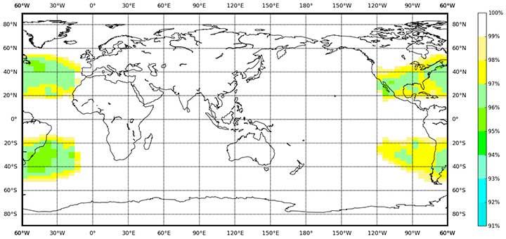
Key Service Areas. In May 2019, the last BDS-2 backup satellite was launched to further improve the performance in the key service areas of the BDS-2 system. As the BDS-3 satellites go into operation, the accuracy and availability of the BDS B1I and B3I signals, in the BDS-2service area, has been improved by about 30% and 5% respectively, compared with that of solely relying on the BDS-2 system.
Global Service Areas. The BDS B1I and B3I service areas have been expanded from the Asia Pacific region to the world, and the accuracy and availability have been further improved. With the condition of PDOP ≤6, the availability is better than 99% in most regions all over the world (in parts of the United States, better than 97%). In the global area, the mean value of the actual measured positioning accuracy is about 3.6m horizontally and 6.6m vertically, velocity measurement accuracy is about 0.05m/s, and timing accuracy is about 9.8 nanoseconds (95% confidence). So far, the BDS-3 new signals, B1C and B2a, have possessed service capacity worldwide. The system availability is better than 87%, in the condition of PDOP ≤ 6. The mean value of the actual measured positioning accuracy is about 2.4m horizontally and 4.3m vertically, velocity measurement accuracy is about 0.06m/s and timing accuracy is about 19.9 nanoseconds (95% confidence).
Building of the Featured Capacity. The BDS/GNSS ground based augmentation system has been providing basic services. It consists of 155 framework reference stations and nearly 2,200 regional stations in China. The system has carried out high-precision applications in many fields, such as surveying and mapping, land resources, earthquake, transportation and meteorology. Its basic services include real-time positioning at the meter, decimeter and centimeter level, as well as precise post-processing positioning at the millimeter level.
The BeiDou Satellite-Based Augmentation System (BDSBAS) is being developed in accordance with International Civil Aviation Organization (ICAO) standards to provide navigation services with superior accuracy and integrity. In 2019, the first GEO satellite with the BDSBAS payload has been tested in orbit and the satellite is in good condition.
Integrated Applications
As the system construction accelerates, BDS is also making great efforts to strengthen the development of the fundamental products and applications in various fields. The integrated applications adopt the “BDS+” model to stimulate the growth of satellite navigation industry.
Fundamental Products. At present, the fundamental BDS products have been used in such areas as mass market applications, of which the performance has reached or is close-to the world-class level. The development of full-frequency integrated high-precision chips is near its completion, and the performance of the BDS chips will improve further. By the end of 2019, BDS navigation chips, modules and antennas have been exported to more than 100 countries and regions. In 2018, the domestic output value was more than RMB 300 billion (US$43 billion), in which the BDS contribution exceeds 80%.
Industrial Applications. BDS has been widely used in various fields — communication and transportation, public security, agriculture, forestry, animal husbandry and fishery, hydrological monitoring, meteorological forecast, time synchronization, power dispatching, disaster prevention and mitigation — generating significant economic and social benefits. In the field of transportation, by September 2019, more than 6.47 million road operating vehicles and 42,300 postal and express delivery vehicles in China are using BDS, and the world’s largest dynamic supervision system of operating vehicles has been formed, which effectively improved management efficiency and road transportation safety.
In agriculture, a BDS-based automatic driving system has been equipped on more than 20,000 sets of agricultural machinery and equipment, saving 50% of the labor cost. The BDS-based agricultural machinery operation supervision platform and the IoT platform has been serving 10 million units of agricultural machinery equipment, greatly improving management and operational efficiency.
In disaster prevention and mitigation, a tri-level platform covering the national ministry, the provinces, and cities and counties has been built to offer six-tier application services, with more than 45,000 terminals using BDS. The BDS/GNSS high-precision technologies have been applied in the field of geological disaster monitoring, while the landslides in Gansu province have been successfully forecast repeatedly, with time accuracy at the second level and deformation accuracy at the millimeter level.
Mass Market Applications. The BDS-based navigation and positioning services have been adopted by various enterprises in the fields of e-commerce, smart mobile terminal manufacture, location-based services (LBS), the sharing economy and the mass market, thereby changing people’s production and life style profoundly. Mainstream manufacturers in China and around the world have introduced BDS-compatible chips that integrate communication and navigation functions.
According to Chinese market statistics, in the third quarter of 2019, 151 types of mobile phones applying for license have positioning functions, among which 110 models support BDS. Using BDS/GNSS ground based augmentation stations, the spatial-temporal services including centimeter-level positioning, millimeter-level perception and nanometer-level timing services can be provided, while the accelerated positioning services cover 220 countries and regions with more than 390 million global users.
International Development
Bilateral Cooperation. BDS continues to carry out bilateral cooperation with other navigation satellite systems, to promote compatibility and joint applications. China and the United States have set up joint working groups in areas such as compatibility and interoperability, augmentation systems and civil services to continuously develop cooperation and exchanges.
China and the EU set up a technical working group on the compatibility and interoperability between the BDS and Galileo systems to carry out coordination, exchanges and cooperation, under the framework of the China-EU space cooperation dialogue and the International Telecommunications Union (ITU). The agreement between the Government of the People’s Republic of China and the Government of the Russian Federation on Cooperation in the Field of the Use of BeiDou and GLONASS for Peaceful Purposes has come into effect.
In August 2019, China and the Russian Federation held their sixth bilateral meeting in Kazan, Russia, signed the site survey certificate of GNSS monitoring stations, and achieved many cooperation results. In addition, the bilateral cooperation with Iraq, Tunisia and Saudi Arabia has also been steadily promoted.
Multilateral Cooperation. During the 62nd session of the Committee on the Peaceful Uses of Outer Space (COPUOS) in June 2019, an exhibition on ancient Chinese navigation technologies was held at the Vienna International Center with the theme “From Compass to BeiDou,” which vividly demonstrated China’s brilliant achievements in timing, mapping, cartography and navigation science and technology. In April and October, 2019, the second China-Arab States BDS Cooperation Forum and China-Central Asia BDS cooperation forum were held in Tunis and Nanning, China, respectively, to promote the BDS to serve the Arab region and Central Asian countries.
The BDS Overseas Applications Were Steadily Promoted. With BDS high-precision products being exported, BDS has been widely used in different regions and fields, such as land registration, precision agriculture, warehouse logistics in ASEAN countries, construction in Western Asia, airport timing and piling at seas in South Asia, electric power inspection in Eastern Europe, and land survey in African countries. As BDS-3 system continues to improve construction, it will provide quality services for more people in a wider area.
Ratification of BDS by International Standards. BDS has made a clear schedule to be ratified by the ICAO standards in 2020. It has formulated 26 standards in the field of international mobile communication based on the BDS B1I signal, and other standards based on the B1C and B2a signals are being developed. A receiver positioning result output protocol (NMEA0183) and a receiver data exchange format (RINEX 3.04) supporting BDS are to be released. Technical parameters and index information of BDS search and rescue (SAR) payloads are included in relevant COSPAS-SARSAT documents, and the development and in-orbit test of the first batch of SAR payload has been completed. The first BDS standard in the International Electrotechnical Commission (IEC) has been developed and approved and is expected to be released in June 2020.
Future Plans
After BDS achieves global service capabilities by 2020, it will further improve global navigation, positioning, timing and regional short-message communication services, and finalize global short-message communication, international search and rescue, satellite-based augmentation, precise point positioning, and other service capabilities. China’s BDS will contribute Chinese solutions to the world, and give full play of its role, with a renewed attitude, stronger capabilities and better services, to serve the world and benefit humankind.
By Colonel John Claxton Chief, PNT Mission Integration, Air Force Space and Missile Systems Center
Image: USAF
The Global Positioning System has provided the citizens of the United States and the world the gold standard for positioning, navigation and timing (PNT) for the past 40 years. These days, GPS is seamlessly integrated into our daily lives in ways that we hardly notice. In fact, most of us expect GPS to be available in much the same way that our lights come on when we flip a switch or water comes out when we use the kitchen faucet.
None of this is easy, however, and wouldn’t happen if it wasn’t for the incredible work and communication by the members of the GPS Program Office and our terrific enterprise partners. During the next 18–24 months, the GPS enterprise will deliver the new and more powerful modernized GPS III capabilities across all segments of the system, which have been in the works and promised for the past 8–10 years. As we transition to the Space and Missile Systems Center’s (SMC) 2.0, this is a very exciting time for the GPS program. Below are some updates on our major programs.
Program Updates
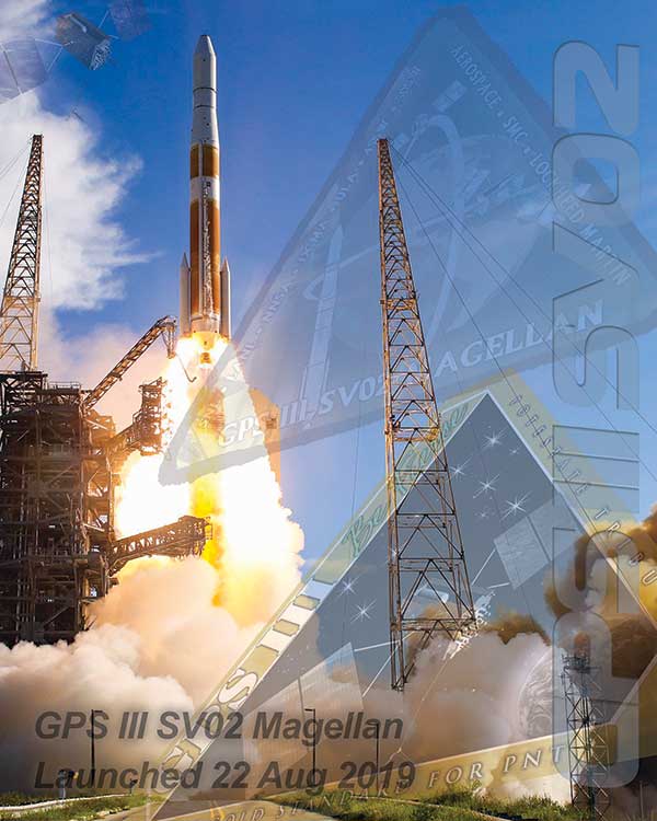
GPS III. The space segment of modernized GPS has reached our goals from 2018, and then some. SV01 “Vespucci” launched on Dec. 23, 2018, heralded by celebrations across the GPS community. The GPS III team was honored to share this event with so many giants of the GPS world. We completed space vehicle (SV) 01’s On-Orbit Checkout Test in July, meeting and exceeding all performance objectives, and plan to transfer SV01 Satellite Control Authority from SMC to the 14th Air Force by the end of the year. SV01 then begins operational testing and is expected to be certified for full operations in April 2020.
SV02 “Magellan” launched on Aug. 22 aboard a United Launch Alliance Delta IV Medium rocket — the last Delta of its class — to much fanfare and celebration as well. We completed SV02 orbit raising and initial checkout in early September, and Magellan is next in line to transition to operations in 2020.
We received delivery of SV03 and SV04 from Lockheed Martin Space Systems on May 16 and Sept. 10, respectively, with launches targeted for March and July 2020.
Challenges remain — this business is hard — but the GPS III team is focused on delivering capability: improving and streamlining the largest big-satellite production line in the Department of Defense and driving our launch campaign to bring modernized capabilities, higher power performance, and the shared international L1C signal to the GPS-using world.
Figure 1. Mature Glonass-M satellites show improved cesium frequency standards performance in terms of daily stability. (Image: Roscosmos)
GPS IIIF. The GPS III Follow-On program looks to continue the success of GPS III as it moves forward in production of the first two GPS IIIF satellites. The program is well into a year-long set of detailed design reviews projected to conclude in March 2020. With Lockheed Martin as the prime contractor for both GPS satellite programs, GPS IIIF can take advantage of production-line improvements learned from GPS III to significantly reduce assembly, integration and test timelines.
Additionally, the program is helping to shape SMC’s Enterprise Commonality Initiative: an effort focused on aligning common products and processes across multiple programs to improve quality, speed up delivery and lower costs. With plans to procure 22 satellites and a delivery timeline spanning 15 years, the program has implemented a technology-insertion strategy and partnered with the Air Force Research Laboratory to ensure a timely transition of new capabilities to meet future military requirements. It is great to see the progress GPS IIIF is making in delivering its new baseline capabilities along with the steps it’s taking toward future capability insertion. The first GPS IIIF satellite launch is forecast for 2026.
GPS Next Generation Operational Control System (OCX). This past year, we used OCX Block 0, also known as the GPS III Launch and Checkout System, to launch and initialize both GPS III SV01 and SV02 and have been flying them in caretaker status until they are ready to be incorporated into the operational constellation. On OCX Block 1, all coding is complete, and the program focus is transitioning from development to system integration, test, and then transitioning the system to operations. Program investments over the past couple of years to change the program culture and modernize the factory infrastructure (often referred to DevOps) is paying off and yielding real-time metrics used to make data-driven decisions and produce higher quality code at a significantly faster rate. As a result, OCX is no longer troubled, but is now a typical large-complex software-intensive program that will experience challenges and risks. Fortunately, the right tools are in place to deliver this critical capability.
GPS Legacy Ground Sustainment. We continue to sustain our existing GPS infrastructure associated with the current Operational Control System (OCS). These sustainment efforts ensure GPS will continue to deliver the gold standard in PNT while providing the crucial on-ramp to incorporate the next generation of modernized GPS capabilities. We operationally accepted the largest OCS upgrade in GPS history. This upgrade, known as Version 7.5, virtualized the network, implemented two-factor authentication, secured connections to worldwide ground antennas, and improved encryption for mission data.
Challenged with a need to rapidly mitigate mission risk and provide enhanced cyber protection, the Red Dragon Cybersecurity Suite (RDCSS) emerged as the GPS OCS monitoring platform, providing data aggregation, analytics and multi-level Indicators of Compromise (IOC). It has evolved into an efficient and effective means to detect, investigate, and report security events and incidents.
Additionally, in August 2019 we established an RDCSS connection into the Space Enterprise Defensive Cyber Operations (DCO) solution, known as the Cyber Defense Correlation Cell for Space. This created a layered defense and a tiered DCO environment for protecting and sustaining the GPS mission.
GPS User Equipment. Over the past year our soldiers, sailors, marines and airmen continued testing and integrating mature, next-generation GPS receiver cards that provide more accurate and reliable positioning, navigation and timing. The first
Military GPS User Equipment (MGUE) receiver card was qualified this year, and the core technologies are being leveraged to develop many other types of GPS receiver cards for a wide range of DoD weapon systems. This exciting work is the culmination of nearly two decades of modernization efforts throughout the GPS enterprise.
In the near term, we are utilizing M-code-capable lead platforms — the USAF B-2 Bomber, USMC Joint Light Tactical Vehicle, USN Arleigh-Burke Class Guided Missile Destroyer and Army Stryker combat vehicle — to prove those capabilities. The second increment of MGUE now underway will focus on requirements for precision-guided munitions, a joint common modular handheld unit, as well as circuit cards and components for low size, weight and power needs. With MGUE, the DoD and services are poised to have enduring PNT solutions the warfighter can leverage for years to come.
GPS Integration Roadmaps
Integration of modernized GPS III capabilities into our major programs is a key focus of the GPS Program Office as we deliver capabilities to our warfighter and civilians users. We have continued to refine our plans and further integrate our programs and teams to ensure a seamless transition and continued high level of service.
Enterprise Road to Launch (ERTL). The Road to Launch team achieved an historic victory of firsts in December 2018. We successfully launched GPS III SV01, the first of its class. SMC partnered with SpaceX to launch SV01 aboard a Falcon 9 rocket — their first National Security Space Launch. SV01 reached orbit under the command and control of our first GPS OCX delivery, the GPS III Launch and Checkout System.
This colossal accomplishment of firsts was only possible because of the exceptionally close integration, tenacity and highly collaborative effort among all players in the community — spacecraft, payloads, launch, control, signal monitoring, acquisition, operations, test and many others. For SV01, the ERTL has now passed the torch to the Enterprise Road to Mission team — but the Road to Launch team is as busy as ever.
The mission planners, launch and orbital operations crew ensured SV02 reached medium Earth orbit with needle-threading precision in August; the team is implementing improvements based on experience as we prepare for up to three more GPS III launches in 2020; and we are already ramping up efforts to design the launch campaign for GPS IIIF.
GPS Enterprise Road to Mission (ERM). With two GPS III satellites now on orbit, it is now time to execute the Enterprise “Integration Playbook” we have developed and coordinated over the past year. The Contingency Operations (COps) modification upgrade has now been integrated into OCS on the 2 SOPS operations floor and is undergoing Developmental Testing with the GPS III SV on orbit. The program anticipates operational testing in January 2020 and Operational Acceptance in April 2020. All of our community stakeholders are ready, and with the COps modification to OCS in place, it is time to get the GPS III satellites into mission and start providing its new capabilities to our users. Over the next few months, the GPS III capabilities are expected to be operationally certified and ready for use.
GPS Enterprise Road to M-Code Mission (ERM-M-Code). With COps now in place, the next major delivery will be M-Code Early Use modification to OCS, installation of new M-code signal monitoring equipment at sites around the globe, modification of mission planning software, MGUE Increment 1 development, service lead platform integration efforts, and operationalization of space receivers. It is our continued objective to improve the ability of the Combined Space Operations Center, to respond to urgent PNT needs of the combatant commanders as they engage more sophisticated adversaries. We remain closely aligned with our peers at USSTRATCOM, AFSPC and our worldwide users across the Joint Service and allied team.
Conclusion
It has never been a more exciting time to be part of the GPS program and enterprise. Our outstanding government and contractor teams have worked so incredibly hard on integrating and communicating our programs to ensure the successful and seamless delivery of GPS III capabilities to both our warfighter and civilian users. It is a great world we live in today, and GPS makes it even better.
Collins Aerospace is one of the world’s largest suppliers of aerospace and defense products, and joins founding-member companies John Deere, Garmin and Trimble as well as 11 national organizations who make up GPSIA’s affiliates program.
Collins will further bolster the Alliance’s goal of enhancing GPS innovation, creativity and entrepreneurship.
“We are excited to welcome Collins Aerospace as the newest member of the GPS Innovation Alliance,” said GPSIA Executive Director J. David Grossman. “As one of the leading aerospace companies in the world, Collins has a long and deep history with GPS technology, beginning with the first GPS signal ever received from the roof of their facilities in Cedar Rapids, Iowa. We look forward to working with Collins Aerospace as the newest member of GPSIA and are confident that they will be a valuable addition in our efforts to heighten awareness of the economic importance and societal benefits of GPS.”
“GPS technology is vital to Collins Aerospace, enabling us to achieve innovative solutions for the aerospace and defense industries,” said Frank Zane, associate director of Business Development, Position, Navigation, Timing (PNT), Collins Aerospace. “We are thrilled to join the GPS Innovation Alliance in their long-standing efforts to ensure the continuous availability, accuracy, reliability, and resiliency of the GPS constellation.”
The GPS Innovation Alliance was founded by Deere & Company, Garmin International, Inc. and Trimble Inc. The alliance recognizes the ever-increasing importance of GPS and other GNSS technologies to the global economy and infrastructure and is firmly committed to furthering GPS innovation, creativity and entrepreneurship.
A new Glonass-M navigation satellite is now aloft, preparing to join Russia’s GLONASS constellation.
The satellite launched Dec. 11 at 11:54 Moscow time aboard a Soyuz-2.1b launch vehicle from the Plesetsk cosmodrome, the Russian Ministry of Defense’s Information and Communications Department said.
The launch was initially scheduled for December 10, but was postponed for a day for technical reasons.
Glonass-M satellites form the basis of the orbital constellation of the GLONASS system. They provide navigation information and accurate time signals to land, sea, air and space consumers.
The Ministry of Defense noted that pre-launch operations and the launch of the rocket were normal. “Means of the ground-based automated spacecraft control complex of the Russian orbital group controlled the launch and flight of the rocket,” the military department said.
The Fregat booster unit was manufactured by NPO Lavochkin (part of Roscosmos State Corporation.) The Glonass-M navigation satellite was produced by ISS Reshetnev (Reshetnev Information Satellite Systems).
By Tony Murfin GPS World Professional OEM Contributing Editor
In today’s world where local conflicts can spill over into many other places, it’s become common to encounter GPS signal jamming. Even in locations that defense forces might have considered “backwater” in terms of technology, enemies can apparently launch attack drones, jam adjacent countries, and generally render GPS, if not GNSS, useless for navigation.
The U.S. military came up with anti-jam technology to counter foreseen jamming scenarios several decades ago, but the initial seven-element controlled radiation pattern antenna (CRPA) designs were bulky and required multiple RF antenna cable connections to large, remote receiver processor units. These units not only processed the signals to derive position, but also eliminated jammer and satellite signals in the direction from which the jamming signal was received (null processing). Most of these early units were large and power hungry, so their application was limited to larger aircraft and ships.
Anti-jam technology has gradually evolved over time. Component integration and miniaturization has enabled CRPA performance to be self-contained within the antenna enclosure. At least one design has now migrated the null-processing into the same enclosure as the CRPA antenna, and is sold on a commercial basis to several military forces around the world. The device outputs a single composite RF signal that has been cleaned of any detected jamming signals for use by both commercial and military remote receivers alike.
Now Quantum Reversal (QR) — a new company based in Calgary, Alberta, Canada — has come up with a novel design that processes the CRPA signal in the RF domain, eliminating the need for extensive null-processing electronics. Without these signal-processing electronics, power requirements are reduced from about 15–30 watts to around 1 watt, the size is smaller (4 inches in diameter versus the nominal 6–8 inches in diameter), and cost is significantly lower. These reductions might allow this new anti-jam technology to move into small unmanned aerial vehicle (UAV) applications, timing networks, and reference monitoring networks where continuous uninterrupted GPS/GNSS service is mandatory.
This antenna is designed to enable continuous navigation using GPS or GNSS signals in the presence of unintentional low- to medium-power interference signals. It should be able to reduce the power of an unintentional interference or jamming signal by 35–45 dB, depending on whether it contains three or four CRPA antenna elements.
Increasing the number of antenna elements of the QR design improves the null depth (on average 8–10 dB per antenna element) at the expense of increased circuit complexity, power consumption and antenna size. An average null depth of –70 dB may be possible with a seven-element CRPA antenna. (Image: Quantum Reversal)
On CBS’ Sunday Morning show Dec. 1, correspondent David Pogue was invited into the Air Force’s GPS Master Control Station at Schriever Air Force Base in Colorado Springs, Colorado, to show viewers what GPS is all about.
Pogue discussed the GPS program with Brigadier General DeAnna Burt, who oversees the program as the director of operations at Air Force Space Command at Peterson Air Force Base in Colorado Springs.
He also discussed GPS vulnerabilities with Dana Goward, president of the Resilient PNT Foundation and contributor to GPS World magazine.
Pogue also visited Lockheed Martin’s satellite assembly facility, where the new generation of GPS III satellites is being built.
Europe’s scattered monitoring of GNSS signals found almost 500,000 interference events over three years. About 59,000 were clearly intentional. European standards for resilient receivers have been published and acquisition of an interference detection network is underway.
Russia is improving its terrestrial Loran/Chayka PNT system for military use and has promised to make the upgraded service available to civilians.
China has retained its terrestrial Loran PNT system as an augmentation/backup for its BeiDou GNSS. It is also testing PNT satellites in low earth orbit (LEO) to provide more powerful and reliable signals than available from current GNSS.
In contrast to the actions of other countries, little is being done in the United States to protect civilian GPS/GNSS users.
The U.S. Department of Defense (DoD) has been very active protecting its own with GPS M-code signals and receivers. It is exploring use of LEO communications satellites and high-powered, low-frequency ground transmissions, such as Loran, to add to the GPS signals.
Yet DoD claims civilian use of GPS has limited its ability to use it as a military tool. It says it has no intention of sharing any new PNT systems with civilians.
At the same time, the 99% of GPS use in the U.S. that is non-military is arguably more important to the nation’s safety and security. GPS signals are used by every networked technology and every mode of transportation. They are so important that officials at the Department of Homeland Security have called GPS “a single point of failure for critical infrastructure.”
The U.S. military recently updated its PNT strategy, has a designated leader for its PNT efforts, and clearly defines the responsibilities of its various staffs and organizations.
Civil agency responsibilities were last updated in 2004 and are spread across more than a dozen departments, agencies, and staffs.
Most significantly, no one is in charge.
This has meant that over the past 15 years, many of the civil mandates and responsibilities to protect signals and users have gone unfulfilled. As just one example, rather than ramp up to address increases in jamming, the Federal Communications Commission has reduced its enforcement equipment and staff.
Putting someone in charge is key to reversing America’s civil PNT decline and energizing both federal and private stakeholders.
A single, empowered federal leader should be responsible, not for doing everything, but for leading and coordinating federal and other civil efforts. This would be someone to be held accountable, and to hold others accountable — an evangelist for the essentiality of these services, and their advocate at the highest levels of government.
Such a leader should be positioned outside the daily turmoil of the White House and National Security Council. They should be in the civil department with the portfolio that most depends on GPS and other PNT. The one that suffers first when GPS and other PNT are not available — the Department of Transportation (DOT).
DOT is already the federal interface with civil GPS users, and co-chairs the national PNT executive committee with DOD. A few edits to national policy and a few staff reassignments could establish a national PNT leader in DOT and make all the difference.
Regaining U.S. PNT leadership is essential to America’s future security and prosperity. We must take the first step by appointing and empowering a single federal leader to make it happen.
On Dec. 3, four U.S. engineers were awarded the 2019 Queen Elizabeth Prize for Engineering during a ceremony at Buckingham Palace for their work creating the first truly global, satellite-based positioning system, GPS.
The QEPrize is the world’s most prestigious engineering accolade, a £1 million prize that celebrates the global benefit of engineering innovation on humanity. The honorees were announced in February.
His Royal Highness The Prince of Wales presented the trophy to Dr. Bradford Parkinson, Hugo Fruehauf, Richard Schwartz and Anna Marie Spilker, who accepted the award on behalf of her late husband, Professor James Spilker, Jr. Learn more about Spilker from his wife’s account.
Bradford Parkinson — often regarded as the “father of GPS” — led the development, design, and testing of the system. Hugo Fruehauf developed a highly accurate, miniaturized atomic clock, a foundational component of the system. Richard Schwartz engineered a satellite hardened to resist intense radiation in space, with a lifespan three times greater than expected. Professor James Spilker, Jr, was the main designer of the GPS civil signal and, with his team at Stanford Telecommunications, built the receiver that processed the first GPS satellite signals.
Lord Browne, chairman of the Queen Elizabeth Prize for Engineering Foundation, highlighted the critical role of collaboration in engineering, and in groundbreaking innovations such as GPS: “Our laureates’ success was the result of inter-disciplinary collaboration, a drive for excellence, and an ability to turn the fruits of scientific discovery into practical solutions. That is what engineers do,” he said.
Today, an estimated four billion people around the world use GPS. At just $2 per receiver, GPS provides an accessible service and a powerful tool that people can integrate with their applications. Simple smartphone apps can track disease outbreaks, self-driving tractors can optimize crop harvests, and sports teams can improve team performance. New applications for GPS continue to revolutionize entire industries, and its annual economic value has been estimated to be $80 billion for the USA alone.
GPS combines a constellation of at least 24 orbiting satellites with ground stations and receiving devices. Each satellite broadcasts a radio signal containing its location and the time from an extremely accurate onboard atomic clock. GPS receivers need signals from at least four satellites to determine their position; they measure the time delay in each signal to calculate the distance to each satellite, then use that information to pinpoint the receiver’s location on earth.
This year’s QEPrize trophy was designed by 17-year-old Jack Jiang from Hong Kong. Jack’s elegant trophy design won the 2019 Create the Trophy competition, an international competition that invites those aged between 14-24 around the world to submit innovative trophy designs for the world’s leading engineers. The 2019 competition saw a record number of entries, with submissions stemming from over 50 countries worldwide.
From left: Lord John Browne, Richard Schwartz, HRH The Prince of Wales, Bradford Parkinson, Hugo Fruehauf, Anna Marie Spilker at the Queen Elizabeth Prize for Engineering ceremony at Buckingham Palace, December 3, 2019. (Photo: Jason Aldean)
Lord Browne of Madingley, Chairman of the Queen Elizabeth Prize for Engineering Foundation, said, “This year’s laureates have demonstrated that engineering makes things happen. With the first global, satellite-based positioning system, they created an engineered system which provides free, immediate and accurate information about position and time, anywhere around the globe.
“The world now depends on GPS completely and without exception. The high-frequency trading systems, telecommunications and electricity grids of today are all built around GPS. And we will rely on it for the drone delivery systems, self-driving cars and climate monitoring solutions of tomorrow.
“In honoring the 2019 prize winners, we hope to inspire the next generation of engineers to continue to push back the frontiers of the possible.”
Bradford Parkinson said: “Today marks a landmark moment in all of our lives—there is no prize for engineering greater than this, it is an honor. This recognition reflects the responsibility incumbent upon those developing technology today to strive to do so for the good of humanity. Day-after-day, we are astounded at the new ways in which people across the world use GPS. It is a ‘System for Humanity’ in each and every sense.”
Hugo Fruehauf said: “The accuracy of modern GPS satellites astounds me. The atomic clocks we built for the satellites were accurate to within billionths of a second, but today’s generation are working a factor of 100 times better than that. They’re a lot like wine, in a sense—they only get better with time. And they have to be accurate; the timing for GPS is used for core systems around the world—vital infrastructure like banking systems, telecommunications networks, and power grids. Today the world relies on those clocks.”
Richard Schwartz said: “One of the best things about GPS is its accessibility. We designed the system to produce a signal that anyone can use, regardless of where they are on the planet. Today, engineers around the world can still access that signal, for free, and use it to build creative solutions to benefit people around them. It took a great deal of collaboration to make the system work, and it’s great to see the next generation collaborating on innovative products now because of that.”
Anna Marie Spilker, on behalf her late husband, Professor James Spilker, Jr, said: “Jim’s mission statement has always been to create, teach, and mentor for world-changing benefits to humanity through his engineering talents. When working on GPS, Jim knew that it could be of profound benefit globally, and he was right; because of their work, Jim and his colleagues have helped billions of people around the world. He was immensely proud of that. He said many times that ‘Engineering technology is the necessary catalyst for progress to world changing benefits to humanity; it’s magic.’”
A new post-Brexit GNSS “must be secured,” according to the UKspace trade association. On Nov. 21, UKspace published its manifesto for a future British government to consider, which includes actions that will enable Britain to compete in the “new space race.”
Among the recommendations is a satellite system to provide navigation services.
“The UK’s post-Brexit participation in a new global satellite navigation system must be secured, whether through ESA or a sovereign capability,” the manifesto said.
“The 2019 Spending Review committed to continuing to provide £191M of funding to support Brexit-related activities ‘including the development of a UK Global Navigation Satellite System option and delivering business stability for company law and audit.’
“Following this initial design phase, the estimated cost of the programme is £5B. This needs to be reflected in long-term budget lines to sustain key precision, navigation and timing skills in the industry.”
Other topics in the manifesto include increased funding for the European Space Agency (ESA), establishment of a national space program, continuing to partner on Copernicus, and funding for the new National Space Council.