This month, the University of Texas at Austin became a major research hub for the U.S. Army Futures Command.
On Oct. 12, the Futures Command broke ground on a $130 million research facility at the Texas A&M University System’s RELLIS Campus in Bryan, Texas. Efforts at both locations will include research on advanced and assured positioning, navigation and timing (PNT) systems.
The Army Futures Command was established in Austin during the summer of 2018. It has been working to build long-standing partnerships with University of Texas at Austin, Texas A&M University System and others in central Texas.
Groundbreaking ceremony for the Bush Combat Development Complex at the Texas A&M University System RELLIS Campus, named in honor of former President George H.W. Bush. (Photo: Texas A&M University)
“The Army designated UT Austin as a strategic partner,” said Professor Todd Humphreys, faculty lead for the Radionavigation Laboratory at the University of Texas, Austin. “UT will focus on two key areas: assured PNT and robotics.” Humphreys has a background in both.
Humphreys says his organization is eager to begin working with the Army. The main focus of his PNT efforts will be “… leveraging the tens of thousands of communications satellites projected to be in low earth orbit in the next few years for PNT services,” he said. “We are working with a major provider and already have some interesting results we can share.”
A member of Humphreys’s team is expected to discuss this work at a meeting of the National PNT Advisory Board next month.
A secondary focus for Humphreys’s lab will be development of integrated sensing equipment with GNSS, low-earth-orbit PNT, radar, vision, inertial, and communications that can deliver assured PNT for the Army’s mounted platforms.
“Assured PNT is one of the principal platforms we are working on,” said Greg Winfree, agency director of the Texas A&M Transportation Institute, a state agency and member of the A&M System. Winfree is also a board member for the RNT Foundation. “Our efforts will be complementary and collaborative with UT’s lead role.”
Winfree sees new PNT sources and their intersection with automated vehicle technologies, drones and robotics as an ideal area for his organization’s contributions. “Our core themes include four application areas that the A&M System could credibly bring forward: RF testing and analysis, vehicle communications and connectivity, unmanned aerial systems, and precision agriculture.”
This could generate a number of spinoffs for civilian agriculture. “Precision Agriculture is a key consideration since reliance upon GPS is a core technological underpinning. Texas A&M has the premier agricultural science program in the country.”
He sees specific areas ripe for investigation by A&M as including:
Creating software defined chips/modules and developing miniaturized antennae for new signal sources
Addressing the potential for degraded sensitivity posed by antenna miniaturization
Developing multi-frequency radios and sensors to allow automated vehicles, drones and robotics to seamlessly utilize GPS along with signals from sources such as ELoran, DSRC, C-V2X, and 5G
Developing AI equipped aerial and underwater drones to test functionality and reliability of signals in challenging environments.
The A&M System has a strong team to bring to bear on such issues, according to Winfree. It includes Dr. Stephen Cambone, associate vice chancellor for research security for the A&M System and the first DoD undersecretary for cybersecurity, and Dr. Byul Hur, assistant professor of engineering technology and industrial distribution and head of the A&M Radio Frequency Test Group.
Dana A. Goward is the president of the Resilient Navigation and Timing Foundation.
Eutelsat Communications is investigating an incident on one of the two solar arrays on its Eutelsat 5 West B satellite. The satellite, launched Oct. 9, carries a payload for the European GNSS Agency (GSA) called GEO-3. GEO-3 is designed to be aboard a geostationary satellite to augment GNSS signals.
Eutelsat is working to assess the potential impact on the performance of the satellite and will communicate on it as quickly as possible, according to a statement from the company.
Eutelsat Communications said the satellite is fully insured against the eventuality of loss by a launch-plus-one-year insurance.
Eutelsat 5 West B hosts the GEO-3 payload of the European Geostationary Navigation Overlay System (EGNOS) under a 15-year agreement signed in 2017 with the European GNSS Agency (GSA), and valued at approximately $112 million dollars (102 million euros).
The EGNOS payload, manufactured by Airbus Defence and Space, will hone the accuracy of satellite navigation signals over Europe for use in aviation, maritime and other industries as part of the European Geostationary Navigation Overlay System (EGNOS).
Revenues generated in Financial Year 2018-19 by Eutelsat 5 West A, the satellite that West B is intended to replace, amounted to about $33.3 million (30 million euros).
With Brexit on the horizon, the U.K. Space Agency is interested in creating its own GNSS.
The agency is investing in research and development that explores challenges and ideas around receivers for a future UK global navigation satellite system.
Specifically, the agency is seeking UK organizations that are interested in investigating and developing concepts for satellite system receivers.
Following Brexit, the UK would be locked out from the European Union’s Galileo-provided services, including the upcoming Public Regulated Service (PRS), an encrypted navigation signal for governmental-authorized users and sensitive applications such as the military.
Tells Space Advisory group spectrum issues a concern for all
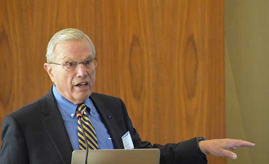
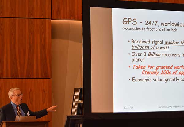
Speaking to a gathering of space industry leaders, Dr. Brad Parkinson, the original chief architect for establishment of the Global Positioning System, outlined the threats to GPS signals posed by a proposal from Ligado Networks that is before the Federal Communications Commission (FCC).
The proposal, which was initially approved, has been pending since 2011 over concerns about its impact on reception of GPS signals.
When asked why the proposal has been pending for so long, Parkinson speculated a combination of the enormous sums of money potentially involved and difficulties for the FCC in arriving at an equitable solution were to blame.
“I hope they find some spectrum for Ligado,” he said. “Just not the spectrum they are asking for.” Referring to the powerful proposed transmissions in frequencies adjacent to those used by weak GPS signals, he said “You don’t want to put a rock band next to a retirement home.”
“You don’t want to put a rock band next to a retirement home.”
Parkinson was speaking to the National Space Council’s User Advisory Group (UAG). The UAG was chartered under the Federal Advisory Committee Act in December 2017. Membership includes the CEOs of Lockheed, Boeing and other companies with interests in space, the Governor of Alabama, five former astronauts, and other leaders in space technology and policy.
This was the first time the UAG’s agenda focused on GPS and positioning, navigation, and timing issues. Parkinson was invited to discuss the activities of the U.S. National Space-based Positioning, Navigation, and Timing Advisory Board. The UAG was interested in learning from the PNT Advisory Board’s experience, and about some of the issues it has encountered over the 15 years since its establishment in 2004.
Parkinson used the PNT board’s experience with adjacent band compatibility and the Ligado proposal as an example of a particularly thorny issue. He said the Ligado issue was an ongoing concern that the UAG should share.
Brad Parkinson shared his concerns over lack of Ligado decision with the National Space Council’s User Advisory Group (UAG). (Photo: Rebecca Zia)
Also that spectrum issues writ large should be of great concern to all users of space as the competition for spectrum from terrestrial users will continue increase. He called the Ligado proposal “a grave threat to GPS,” especially for aviation and high-precision users.
During the course of the presentation Parkinson asked for the UAG’s support of the PNT Board’s recommendations on the Ligado proposal. He also asked the group to endorse the National PNT Executive Committee’s adjacent band compatibility methodology to any future such proposals.
Parkinson’s presentation concluded with a discussion of how GPS is increasingly being used to support activities in space. It has long been used for booster guidance during the initial phase of space flight.
Relatively recent work using side lobe signals from GPS satellites has caused engineers to recognize a Space Service Volume for GPS. This allows use of the signals for mid-course launch corrections, satellite station-keeping, rendezvous, and potentially trans-lunar navigation.
Satelles Inc., provider of highly secure satellite-based time and location services, has raised $26 million in Series C funding. C5 Capital led the round, with participation from Iridium Communications and existing investors.
The new investment brings Satelles’s total funding since the launch of its platform to $39 million and will help the company expand its sales and marketing efforts, broaden its partner network, and accelerate product development.
In 2016, Satelles demonstrated sub-microsecond timing using its Satellite Time & Location (STL) service with a stand-alone TCXO-based receiver. In February 2018, the company released new tests using configurations with a differential source and with a more accurate OCXO clock, producing timing accuracy of 160 nanoseconds.
Industry and government requirements for positioning, navigation, and timing (PNT) are expanding at a rapid pace, and the Satellite Time and Location (STL) broadcast signal from Satelles provides assured PNT across a range of applications and at scale.
“Today’s world runs on systems requiring trusted time and location information, and C5 Capital shares our commitment to make it a more secure and better place,” said Michael O’Connor, CEO of Satelles. “We are delighted that C5 led this latest investment round because they bring great insight into cybersecurity, and their international network is unparalleled.”
Attacks such as jamming and spoofing — where a radio transmitter near the target is used to interfere with legitimate GPS or GNSS signals — and hacking are becoming more of a threat because of the key role that GPS and GNSS play in the operation of critical infrastructure.
The STL signal strength is much greater than GNSS because the LEO satellites are much closer. (Slide: Satelles)
According to the company, the Satelles STL platform brings security to telecommunications networks, financial exchanges, electrical grids, maritime transportation systems, and many other sectors that depend on timing or location information.
Downtime or malfunctions in these systems due to such attacks would be very costly. A June 2019 report sponsored by the National Institute of Standards and Technology estimated a $45 billion loss to the U.S. economy if GPS were to experience a 30-day service disruption.
The Satellite Time and Location broadcast service from Satelles is encrypted to thwart malefactors aspiring to spoof or otherwise disrupt the STL signal, which is delivered via the low-Earth-orbit (LEO) satellite constellation operated by Iridium, an investor in this financing round.
“STL addresses a critical and growing need across many applications and industries, so Iridium’s investment in Satelles aligns with our strategic vision,” said Matt Desch, CEO of Iridium Communications. “Satelles’s technology is unique and powerful, and we are proud to host such an innovative service that solves important problems and leverages the unique capabilities of our network.”
The Iridium satellite constellation-based system offers many advantages:
A signal 1,000 times stronger than GPS/GNSS is better at reaching users and facilities in GPS/GNSS-challenged environments such as inside buildings, underground locations, and urban canyons.
Overlapping and constantly moving spot beams enable revolutionary cybersecurity solutions that can rely on trusted time and location for authentication and data access.
Polar-orbiting, cross-linked satellites ensure truly global coverage.
The L-band frequency range allows small, low-cost equipment to receive the Satelles STL signal.
“The capabilities of Satellite Time and Location are enhanced by the technical and service delivery attributes of low-Earth-orbit satellites,” said Dr. Gregory Gutt, President and CTO of Satelles. “An extraordinary constellation such as Iridium’s gives us an incredible platform from which to deliver our trusted PNT solutions, so we remain committed to LEO technologies going forward.”
Commenting on the closure of the Series C investment in Satelles, Andre Pienaar, Managing Partner of C5 Capital, said, “Space is a rapidly developing battleground for cyber threats to critical infrastructure, and GPS is unable to meet all these challenges. Satelles has developed a powerful solution which not only prevents attacks but provides a stronger and more effective service through STL. We are pleased to have led this funding round and look forward to working closely with this remarkable business.”
The Official Journal of the European Union (EU) will publish a funding opportunity in the near future for a GNSS “Advanced Interference Detection and Robustness Capabilities System,” according to officials familiar with the project.
Advance notice of this procurement was first given in August of last year, with an award projected for the first quarter of 2019. Some observers have speculated that the procurement delay was related to a change in how the final system is envisioned. The current version of the notice asks for a crowdsourcing, software and networked-based solution.
The advance notice calls for the vendor to both establish the system and operate it.
The purpose of the present tender is to establish a new mechanism to detect interference at receiver and antenna level based on crowdsourcing and sharing information coming from any user (individuals or associated ones) and run the service for a period of two years.
While for many “crowdsourcing” suggests the participation of large numbers of individuals, this will likely not be part of the scheme. Speaking to a government advisory board, Jean Yves Courtois, CEO at Orolia, said that battery drain on cell phones would prevent this from being practical. “Privacy concerns would also be an issue,” he said. Each individual would have to affirmatively agree to have their location information used continuously. This additional administrative burden would be significant.
Much easier and preferable would be using Information from already deployed networks of fixed receivers, such as base stations. Unchanging locations and existing network connections make the engineering easier and thorny privacy concerns would be minimized. These ideas are also reflected in the current version of the advance notice:
The activity shall also focus on identifying and engaging users (such as entities currently monitoring vast networks of devices integrating GNSS receivers) by means of an appropriate enrolment scheme ensuring the provision of the data. The design of the system shall ensure that the sensitivity of the data (GNSS vulnerabilities) is always protected.
Crowdsourcing and collating such information is seen by many in industry as a relatively straight-forward engineering problem. Representatives from Orolia and Microsemi, for example, included ideas about crowdsourcing disruption data in recent presentations to the U.S. PNT Advisory Board. Both agreed, though, that there are few commercial incentives to do such work without a government customer.
It is perhaps not a surprise that the EU is taking the lead in this field while other GNSS providers seem to have little interest.
Unlike GPS, GLONASS and BeiDou, which are first and foremost national security systems, Europe’s Galileo was built and is operated by a civil organization focusing on economic and civil benefits. Interference with signals directly undercuts these benefits and can be easily seen in direct economic costs.
Many European countries are using GNSS for road tolling, for example. Small GNSS jammers are easy to acquire off the internet and their illegal use is likely costing nations millions of euros in lost tolls each year. Without the ability to regularly detect, sanction, and deter this activity financial losses will continue to mount.
The interference with tolling problem is not specifically addressed in the EU’s advance notice. It may well be that tolling authorities and others will be expected to install their own application specific interference detectors and then encouraged to link them to the EU backbone and database.
The European Commission has been aware of this vulnerability for some time. In 2015 it contracted with Nottingham Scientific Ltd. in the UK to lead a multi-nation team and assess the extent of the problem.
The STRIKE3 project was in operation from February 2016 to January 2019. Its goals were to sample and classify interference events, recommend a standard event reporting scheme, and assess the vulnerability of different types of GNSS receivers.
The project’s sampling activity in 23 different countries detected nearly 500,000 interference events. Of these, 59,000 were classified as deliberate attempts to disrupt GNSS signals.
Within the deliberate events the STRIKE3 team were able to identify about 300 jammer “families,” according to Mark Dumville, Co-Founder and Director at Nottingham Scientific. Along with the jammers they were able to classify into groups, there were “some very interesting outliers,” Dumville said. “These are likely evidence of jammer technology continuing to develop and evolve.”
STRIKE3 is viewed as a very successful project by most everyone in the international PNT community, and certainly within the EU, according to officials.
The upcoming announcement and future establishment of an on-going interference detection capability are some of the next logical steps to better securing Europe’s PNT services.
Galileo and EGNOS were the focus of attention at a special workshop at this year’s Intergeo in Stuttgart, which took place in September. Intergeo is the world’s leading conference and trade fair for geodesy, geo-information and land management.
Intergeo provided an opportunity to give an update on the status of the Galileo and EGNOS programs and to present user case studies at a special workshop focusing on the geomatics market.
In his presentation at the conference, Eduard Escalona, Market Development Innovation Officer at the European GNSS Agency (GSA), stressed the key role of GNSS.
“GNSS is a cornerstone in many areas: It is a fundamental element for cadastral surveying, in the construction sector, in mining, land surveying and mapping activities, for all geographic information systems (GIS), for infrastructure monitoring and for marine surveying. For all of you who are working in these and many other areas, Galileo is now helping to provide the GNSS services you need,” he said.
Dual-frequency boosts market
The European GNSS programs, Galileo and EGNOS, continue to move forward in terms of adoption by the professional market and among general users, thanks in no small part to the development of dual-frequency capability.
Traditionally, mobile, location-based applications have been powered by single-frequency GNSS receivers operating under stringent battery-power and footprint constraints. With a dual-frequency chipset, these devices now benefit from better accuracy, ionosphere error cancellation, improved tracking and better multipath resistance.
Galileo is leading the way in the area of dual-frequency signal delivery, now with more dual-frequency operational satellites in orbit than any other GNSS system. Market uptake of Galileo receivers has been impressive; in addition to the geomatics-related areas of particular interest to the Intergeo public, dual-frequency GNSS chipsets are also appearing in the automotive sector, where connected cars and autonomous vehicles present a clear and pressing need for accurate and reliable positioning information.
New services to come
“To date, more than one billion Galileo-enabled devices have been sold,” said Escalona, “but Galileo isn’t standing still, waiting. We are proposing new services to appear in the coming years.”
These include the much-anticipated High-Accuracy Service (HAS) and a new Authentication Service. “The HAS will be a free, globally available service providing an accuracy of 20 cm, with PPP [Precise Point Positioning] corrections,” Escalona said.
Meanwhile, the Authentication Service (OS-NMA) will provide protection against jamming, spoofing and meaconing on the E1B signal and a separate Signal Authentication Service (SAS) will provide an even higher level of protection on the E6 signal.
“EGNOS is currently working with GPS, but of course we are looking forward to augmenting Galileo in the near future,” said Sergio Cabrera Bona, EGNOS Service Adoption Tools Engineer at the European Satellite Services Provider, whose core activities comprise EGNOS operations and service provision.
“GNSS is critical in all of these fields, whether it is mapping and GIS, farming, forestry, thermal pictures, management of natural terrains,” Cabrera said. He listed other areas, including management and inspection of utilities, power networks, water supply, telecoms, drones, inventory, surveying, field campaigns and determination of perimeters in agriculture as areas where GNSS plays a key role.
“It is not possible to mention all of the activities where you need reliable positioning. What you have to know is that with EGNOS augmentations you already have a horizontal accuracy below one metre and a vertical accuracy below two metres, so this is a very good accuracy,” he said.
There is much more that could potentially be done right now, Cabrera explained. “Most of the professional equipment is already EGNOS-enabled, but in practice users do not always configure their equipment correctly to exploit this capability. EGNOS adoption and support is going ahead full speed, but in the GNSS device market, many users still do not know they can use EGNOS. So the education process remains an ongoing effort,” he said.
Cabrera explained that the EGNOS user support website can be an important part of this educational drive on the top of the help desk. “We have very interesting tools and resources available online. For example, we will have a new EGNOS usability map available very soon on the website. With this tool you will be able to easily see the current availability of EGNOS signals in your location, which will be very useful especially in urban environments, for example. We also have many user support services and there is a new mobile app coming, so please visit our website and take advantage of EGNOS. It is there for you.”
Introducing the GSC
Galileo services improvement expert Pedro Gómez Martínez informed participants about the European GNSS Service Centre (GSC), defining both the concept of operations as well as the procedures necessary to provide the services that the GSA offers to Galileo users.
“The European GNSS Service Centre is the single interface between the infrastructure and users of the Galileo open services, commercial service and search and rescue service (SAR),” said Gómez. “So the GSC is a center that provides experts, know-how, evaluation of capability, distribution of information and support for the provision of value-added services provided by the Galileo system.”
The GSC website is a core resource for Galileo users, Gómez said, reporting real-time system status and incident notifications, with a bank of key documents and a full-time help desk. “It is very important for us that this is a two-way interactive service that includes your feedback. We need you to report any incidents that you might experience related to the product, service and data provision. We are very interested in user satisfaction, and we want to know how you respond to improvements. And of course, in general, we are here to promote GNSS in all its forms, in all areas, for all users.”
The GSC launched a new version of its website in the run-up to the InterGEO event. “More than ever we are making it easier for you to engage in dialogue with us and to provide your feedback. This is very important to us with new services coming up in the future,” Gomez said.
Research fundamentals
“One of the very important responsibilities of the GSA is the management of a number of EGNSS research and development programmes,” said Eduard Escalona. “We have Horizon 2020, the European Union’s research Framework Programme. There we have a final call for proposals coming up in November, with a deadline in March 2020. The GSA also is overseeing the Fundamental Elements programme, which is funding research specifically targeted at developing Galileo-enabled chipsets, receivers and related technologies.”
To illustrate Escalona’s point, the presentations featured EU-funded GNSS-related research projects leveraging the accuracy and integrity offered by Galileo. Pere Molina of Geonumerics presented the MapKite project. Funded under Horizon 2020 and now completed, MapKite integrates an unmanned aerial system (UAS) and a mobile mapping aystem (MMS) for simultaneous capture of geo-data from the air and from the ground. Molina showed data from a successful corridor mapping exercise run using the MapKite system.
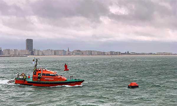
Operation Shark Bait showed how this vital service can quickly trigger a rescue operation and save lives at sea. Despite a grey day and choppy sea conditions, an emergency rescue was initiated in just over three and a half minutes after intrepid “volunteer victim,” Australian broadcaster and explorer Tara Foster, operated her Galileo-enabled SAR beacon from a small life raft buffeted by the waves just offshore from the port of Ostend.
Operation Shark Bait was a specially designed demonstration of the capabilities of the Galileo SAR service that took place around the new state-of-the-art Belgian Maritime Rescue and Coordination Centre (MRCC) in Ostend with an invited audience of VIPs and media. The whole operation was streamed live over YouTube and the Europe By Satellite (EBS) TV service.
The Shark Bait test took just over three and a half minutes to locate the PLB developed under a GSA Horizon 2020 project. (Photo: GSA)
The scenario was simple. Tara was left alone at sea in a small life raft, but with a 406-MHz Cospas-Sarsat personal locator beacon (PLB). On activating the beacon, the stopwatch started. The time to receive the distress signal, compute her position and alert the relevant rescue authorities was recorded. The Belgian fast rescue boat ORKA R6 then dashed out to sea to pick her up.
Subsequently, a NH90 Cayman SAR helicopter from the Belgian 40th squadron was also scrambled to help transfer “injured” Tara to hospital.
Shark Bait was a great success with just 3 minutes 32 seconds elapsing from Tara activating her Galileo-enabled personal locator beacon (PLB) to the moment commanders at MRCC could dispatch the ORKA to her location.
The location, with an initial accuracy of 100 metres, is provided by the Galileo receiver inside the PLB to the Galileo satellites in view. The Galileo satellites then forward this information to the Cospas-Sarsat infrastructure, where the position is validated.
“The PLB used was developed under one of our Horizon 2020 projects and is the first Galileo-enabled beacon on the market,” said Fiammetta Diani, head of market development at the GSA.
Time saver, life saver
The day started at the MRCC in Ostend with a visit to the operations centre, an inspection of the ORKA Fast Rescue Boat and a chance to talk to Tara Foster before she was “castaway” on the waves.
Dries Boodts, deputy nautical director at MRCC, described the role of the center, which has a single focus on safety at sea. “The globe is divided into Search and Rescue Regions (SRRs),” Boodts said. “The MRCC oversees the Belgian maritime region that extends up to 47 miles off the Belgian coast.”
The region includes major shipping lanes and two large offshore wind energy parks. The MRCC deals with around 450 incidents each year involving a range of craft and issues from collisions at sea to war munitions recovery. It can call on an assortment of assets including its own rescue craft, police and navy vessels and the Belgian air force and the MRCC collaborates extensively with authorities in neighbouring countries.
Galileo is Europe’s contribution to upgrading Cospas-Sarsat, the global satellite-based search-and-rescue system. Since its introduction in 1981, Cospas-Sarsat is estimated to have saved 45,000 lives.
The current MEOSAR (Mid-Earth Orbit Search and Rescue) upgrade is based on the EU’s Galileo satellite constellation that carries a dedicated Cospas-Sarsat payload for the 406-MHz distress beacons that give users free access to global system.
The addition of Galileo (and other GNSS satellites) to the system has already enabled a dramatic increase in performance in terms of better accuracy to locate activated distress beacons and vastly improved global coverage.
“With the Galileo system, all parts of the world will be covered at least every 10 minutes — previously this was up to four hours — and guaranteed location accuracy is reduced from 10 to 2 kilometers,” explained Jolanda van Eijndthoven from the European Commission.
As well as the 23 SAR payloads currently provided by Galileo, with more to come, the EU also provides ground infrastructure including MEO Local User Terminals (LUTs) to pick up the signals relayed from the satellites. These LUTs are not just in Europe, and a fourth facility is o be opened soon on La Reunion island to improve coverage across the Indian Ocean.
Return link reassurance
From the end of the year the Galileo system will also provide a Return Link Service (RLS) that will be able to send an acknowledgement to the victim that their distress signal has been received and help is on its way. This new ability to provide reassurance should deliver a valuable psychological lift to victims and further boost survival rates.
“The PLBs developed under our Horizon 2020 projects will be the first ones on the market to have the RLS capability,” said Fiammetta Diani.
Back on dry land, Tara confessed that the simulation had felt very real to her. “The scariest part was the transfer to the helicopter from the rescue boat,” she said. “The winch was like a lift without a floor and very fast! Stepping from the flimsy life raft to the ORKA was also not easy – those waves were high!”
“The operation went just like clockwork,” concluded Paul Flament Head of the Galileo and EGNOS unit at the European Commission’s DG GROW.
A Eutelsat communications satellite launched Oct. 9 carried a payload for the European GNSS Agency (GSA) called GEO-3. GEO-3 is a geostationary satellite designed to augment GNSS signals.
The EGNOS payload, manufactured by Airbus Defence and Space, will hone the accuracy of satellite navigation signals over Europe for use in aviation, maritime and other industries as part of the European Geostationary Navigation Overlay System (EGNOS).
The Eutelsat-5 West B satellite also hosts a payload that will enable service continuity for television broadcasting in Europe and North Africa.
The GSA signed a contract in March 2017 with Eutelsat Communications for the development, integration and operation of the next-generation GEO-3 EGNOS payload.
EGNOS operational messages are broadcast via navigation payloads on-board two GEO satellites, including an Inmarsat-3F2 satellite that is fast approaching end-of-life. The GEO-3 services replenish the EGNOS SBAS payloads, guaranteeing EGNOS availability and supporting the transition to the dual-frequency multi-constellation-capable EGNOS V3.
Eutelsat will also develop two redundant RF ground stations to uplink the EGNOS message to the payload. It will also host EGNOS’ Navigation Land Earth Stations (NLES) in Rambouillet, France, and Cagliari, Italy, both of which will be co-located and connected to the RF ground stations.
Proton-powered launch
The satellite was carried aloft on a Proton rocket along with a second satellite, the Mission Extension Vehicle-1 for Northrop Grumman subsidiary SpaceLogistics, designed to service satellites. Both spacecraft were built by Northrop Grumman.
The Proton rocket lifted off at 6:18 a.m. Eastern Time from Russia’s Baikonur Cosmodrome in Kazakhstan. Its two passengers separated from the rocket 16 hours later in a supersynchronous transfer orbit.
Eutelsat-5 West B is a replacement for the 17-year-old Eutelsat-5 West A satellite.
Raytheon plans to deliver the final phase of the GPS Ground Control System (OCX) upgrade to the United States Air Force by June 2021, despite past delays to the program.
A report by the General Accountability Office (GAO), issued in May, said the Air Force has yet to develop full cost estimates for the new ground system, as well as the user equipment needed to access the expanded capabilities of GPS III.
In the report, the GAO recommended that the Department of Defense (D0D) conduct an independent schedule assessment of the full program schedule at the end of 2019. DOD did not agree with the recommendation.
“OCX delivery, acceptance, and the ready to transition to operations decision will likely be delayed, potentially exceeding the April 2023 threshold date for completing the program,” the GAO report said.
However, Raytheon said Oct. 1 that it had completed software and hardware development and has started testing and integrating the system, keeping it on track to meet its contractual deadline.
In an Oct. 1 Denver Post article, David Wajsgras, president of Raytheon’s Intelligence, Information and Services business, said Raytheon has changed its process for the OCX upgrade by adopting less-traditional tech startup development processes.
The new process —now in action at Raytheon’s Aurora, Colorado, campus — emphasizes collaboration across teams and has a less linear structure.
“I’d call it almost a 180 from the way we had developed software in the past, from the traditional way for the Department of Defense,” Wajsgras told the Post.
“A few years ago the GPS OCX program was considered the No.1 problem program in the entire Department of Defense,” Wajsgras acknowledged. “Our team truly stepped up to the challenge of what needed to be done in order to get one of the most important programs for U.S. government back on track.”
DOD’s Defense Digital Service helped the company apply an “agile” approach to “DevOps” (development and operations) that stresses collaboration across teams as well as flexibility.
The new process includes “dojos,” centers for focused, quick training, and “hives,” open workspaces without cubicle walls.
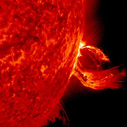
A solar flare in 2015. (Photo: Photo: Solar Dynamics Observatory, NASA)
You wake up and turn on the TV. Your usual shows aren’t airing. You flip on the radio and learn that the Paris and Tokyo stock markets have closed. Back on TV, CNN is trying to use Skype in an attempt to cover what’s happening around the world following a solar superstorm.
In a U.S. bunker, the military has lost contact with armed drones flying over hostile areas in the Middle East. Loss of global communication satellites makes it difficult to send commands and surveillance data to soldiers, ships and aircraft, rendering them vulnerable to attack.
Throughout the day, more challenges arise. First responders don’t have access to their location systems. Delays in ground and air traffic begin to develop. Systems that depend on GPS time stamps — ATMs, power grids, computer-data and cell-phone networks — begin to fail, and the cloud becomes unstable. The internet soon collapses.
These events take place just a few hours into “A Day Without Satellites” as presented by Pål Brekke, solar physicist and senior advisor at the Norwegian Space Agency. Brekke spoke at the plenary session of ION GNSS+ on Sept. 17 in Miami.
Brekke reviewed the Carrington Event of September 1859, the first documented solar superstorm. In that event, a solar coronal mass ejection (CME) hit Earth’s magnetosphere, and its effects were observed and recorded by British astronomers. The storm wrought havoc with telegraph systems.
Today, a solar storm of this magnitude would cause widespread disruptions, blackouts and damage from extended outages of the power grid, communications networks, and of course, GNSS. The solar storm of 2012 was probably as big, but we were lucky — Earth wasn’t in the ejection path.
Without more data, it’s difficult to predict how often such superstorms take place, but it’s a sure bet that the scenario Brekke presented will happen eventually. To prepare, agencies around the world are studying and planning for the phenomenon, including the United Nations Office for Outer Space Affairs (COPUOS), the World Meteorological Organization (WMO) and the International Civil Aviation Organization (ICAO). Space and emergency agencies in the U.S, European countries and other countries are also developing plans.
Good to hear in the face of a threat that would undoubtedly affect us all.
New app gives field crews a fast, easy way to record information while mobile
Esri has released ArcGIS QuickCapture, a mobile app designed for rapid and at-speed field data-collection workflows.
Data can be collected from a moving vehicle with the touch of a button and sent back to the office for real-time analysis, leading to faster and more effective decision-making. The new app is designed for road inspections, aerial surveys, monitoring vegetation encroachment and more.
ArcGIS QuickCapture allows users to configure a customized interface that suits their specific project requirements, eliminating unnecessary features and options. This personalization helps users take advantage of the single-tap, big-button system to capture details and photos as they go. The app is intuitive and user-friendly, eliminating the need for extensive crew training.
The new app integrates with the user’s existing IT infrastructure and ArcGIS platform, which simplifies implementation. It uses the existing GPS and camera on smartphones and tablets, and it is compatible with iOS, Android and Windows devices.
For high-accuracy data collection workflows, QuickCapture is also compatible with external GNSS receivers.
“ArcGIS QuickCapture builds upon and enhances our existing field data collection offerings in ArcGIS,” said Ismael Chivite, senior product manager at Esri. “Field crews are demanding user experiences that are tailored to the way they work. QuickCapture is designed to capture GIS data with the tap of a button, while on the go. At-speed road asset inventories and quick damage assessments are examples of workflows where QuickCapture excels.”