NavtechGPS is offering the following multi-day training sessions on GNSS/GPS technology in New Orleans this December. Both courses will take place at the InterContinental New Orleans Hotel.
Take this 4-day course to gain a comprehensive understanding of GPS/GNSS system concepts, design and operation, including information on GPS signal processing by the receiver; techniques by which GPS obtains position, velocity and time and a brief introduction to differential GPS (DGPS) and Kalman filtering.
Expanded to a full five full days based on attendee requests, this course on GPS-aided navigation will thoroughly immerse you in the fundamental concepts and practical implementations of the various types of Kalman filters that optimally fuse GPS receiver measurements with a strapdown inertial navigation solution. The course includes the fundamentals of inertial navigation, inertial instrument technologies, technology surveys and trends, integration architectures, practical Kalman filter design techniques, case studies, and illustrative demonstrations using MATLAB.
Five fulls days allow for a fuller and detailed development of the design of an aided navigation system, combined with a detailed discussion of the use of lower quality IMUs, and advanced filtering techniques.
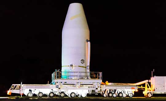
The second GPS III satellite — nicknamed Magellan — is now at the launchpad at Cape Canaveral Air Force Station, Florida, in preparation for liftoff on Aug. 22.
United Launch Alliance tweeted out an image of the encapsulated satellite on its way to the rocket.
The Lockheed Martin-built satellite was originally scheduled for launch on July 25, but the launch was pushed to Aug. 22 because of “an anomaly during component testing at a supplier that created a cross-over concern. Upon further evaluation, additional time is needed to replace and retest the component on the launch vehicle,” ULA said.
Launch Updates
The launch window on Aug. 22 will open at 9 a.m. EDT (1300 UTC) and extend to 9:27 a.m. EDT (1327 UTC), a 27-minute duration. ULA’s live countdown blog begins at 11:45 p.m. EDT (0345 UTC) on Aug. 21. The launch webcast starts at 8:40 a.m. EDT (1240 UTC).
GPS III SV02 will be the 29th and final flight of the Delta IV Medium rocket, the 73rd GPS launch by a ULA or heritage vehicle and marks ULA’s 135th mission.
GPS III SV02 is named Magellan in honor of the Portuguese explorer who led the first expedition to circumnavigate the Earth.
The satellite, encapsulated in the 4-meter-diameter composite payload fairing, was moved overnight last week from its processing facility to the seaside launchpad at a top speed never exceeding 5 mph.
The satellite was hauled by a motorized KAMAG Elevating Platform Transporter (EPT) that provided hydraulic leveling and precision positioning capabilities along the route. The EPT also towed a Portable Environmental Control System (PECS) trailer to supply conditioned air to the payload fairing during the trip.
Once parked in the hoistway on the backside of the Mobile Service Tower (MST), technicians used the crane system in the gantry the next morning to carefully lift the satellite onto the Delta IV rocket’s second stage to complete a successful vertical integration of the launch vehicle and payload. The fully assembled rocket now stands 207 feet tall.
A tip-to-tail electrical test of the combined payload and launch vehicle will occur next, an operation known as the Integrated Systems Test (IST). Once that is completed, the comprehensive process to verify flight readiness will begin in parallel to final vehicle closeouts for the launch targeted for Aug. 22 at 9 a.m. EDT (1300 UTC).
ULA rockets have successfully launched 70 GPS satellites since 1978.
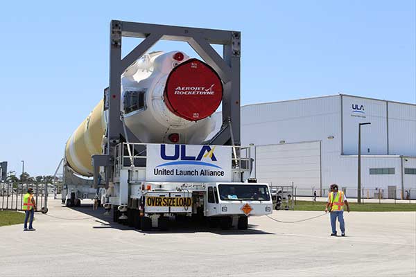
ULA technicians transport the GPS III satellite to the Delta IV launchpad. (Photo: United Launch Alliance)The Delta IV rocket leaves the the Horizontal Integration Facility (HIF) aboard a 36-wheel, diesel-powered transporter on May 28 and traveled to Space Launch Complex-37. The trip took 40 minutes. (Photo: ULA)
The European GNSS Agency (GSA) is looking for experts with a high level of expertise in navigation satellite systems to assist it with tasks related to the implementation of the Fundamental Elements funding mechanism.
The GSA is interested in experts with professional experience in specific market segments such as aviation, location-based services, agriculture, surveying, rail, road, maritime, and timing and synchronisation and/or with hi-tech business building skills.
Specifically, the GSA would like to involve business and technical experts with proven experience in one or more of the following areas:
E-GNSS signal processing;
Development (hardware, software/firmware algorithms etc.) of E-GNSS receivers and antennas;
Applications, services and products in the area of E-GNSS;
E-GNSS technologies state of the art boosting, particularly E-GNSS differentiators.
Experts assist in:
Evaluation of proposals, prize applications and tenders
Monitoring of actions, grant agreements, public procurement contracts
Experts also provide opinion and advise on preparation, implementation and evaluation of EU programmes and design of policies.
No deadline, but apply early
To select experts, the European Union Institutions regularly publish calls for expression of interest detailing the selection criteria, the required expertise, the description of the tasks, their duration and the conditions of remuneration.
The call for expression of interest is permanently open, so there is no application deadline. However, early application is encouraged because the first experts should be appointed in the third quarter of 2019. Anyone interested can register here.
Experts who have already registered in the Participant Portal expert database are invited to log-on here to declare their interest in Fundamental Elements assignments and to update their area(s) of expertise.
For more information and to download the call, click here.
Fundamental Elements
Fundamental Elements is an EU R&D funding mechanism supporting the development of EGNSS-enabled chipsets, receivers and antennas. Fundamental Elements projects are part of the overall European GNSS strategy for market uptake, led by the GSA. The objectives of the programme can be summarised as follows:
Facilitate the adoption of EGNSS, building on innovative services and differentiators;
Improve the competitiveness of EU industry ;
Address user needs in priority market segments ;
Maximise benefits to European citizens.
The total budget for projects to be carried out in 2015-2020 is EUR 111.5 million.
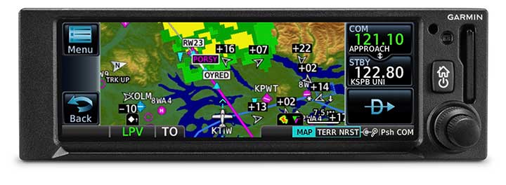
The GNC 355 is a GPS navigator with localizer performance with vertical (LPV) approach guidance and a built-in communications radio. (Photo: Garmin)
Garmin International Inc. has launched the GNC 355 — a GPS navigator with Localizer Performance with Vertical (LPV) approach guidance and built-in communications radio.
With the GNC 355, pilots can take advantage of the benefits of WAAS/SBAS GPS guidance, while also incorporating a modern comm radio into their existing avionics stack.
Intended for Class I/II aircraft that weigh 6,000 lbs./2,721 kg. or less, as well as experimental/amateur-built (EAB) aircraft, the GNC 355 Supplemental Type Certification (STC) is imminent and will be available in August for more than 700 aircraft makes/models.
“Based on the popularity of legacy products like the GX 60 and the GNC 250/300XL, as well as customer excitement for our new GPS 175 and GNX 375, we’re pleased to bring the GNC 355 to market,” said Carl Wolf, Garmin vice president of aviation sales and marketing. “The GNC 355 gives value-minded customers a simple upgrade path to a GPS navigator with a number of capabilities including WAAS/LPV approach guidance, wireless connectivity, a modern Comm radio, and with its standard mark-width form factor, pilots can easily add the GNC 355 without overhauling the panel of their aircraft.”
Aircraft owners can incorporate the GNC 355 into an existing avionics stack because of its standard 6.25-inch wide by 2-inch tall design. A vibrant, colorful and responsive touchscreen display boasts a familiar Garmin user experience, while a dual concentric knob and home button offer added versatility when interfacing with the touchscreen.
The user interface has been optimized for the screen size of the display, while also retaining a familiar menu structure similar to other Garmin products. Pilots can quickly access direct-to functionality, moving map, flight plan, nearest, procedures, waypoint and terrain pages, as well as frequency information using the touchscreen, and create customizable data fields and shortcuts for quick, one-touch access to important information.
Fully WAAS/SBAS IFR-approach-capable, the GNC 355 gives pilots the benefit of flying LPV, as well as Area Navigation (RNAV) approaches. Many approaches offer vertical approach guidance as low as 200-feet above ground level (AGL).
Pilots can also leverage the touchscreen and moving map to generate customized holding patterns over an existing fix in the navigation database or over a user-defined waypoint and easily insert it into a flight plan. Visual approaches are also available within the GNC 355 and provide lateral and vertical approach guidance in visual flight conditions.
Two versions, the GNC 355 and GNC 355A, are available with 25 kHz and 8.33 kHz frequency channel spacing respectively. Using the internal frequency database, airport, weather, Air Route Traffic Control Center (ARTCC) and Flight Service Station (FSS) frequencies are easy to find and can be loaded to the standby position by selecting the frequency from the airport information page. Recent, nearby and saved frequencies also offer easy access to frequency information. For example, with built-in standby frequency monitoring, pilots can listen to ATIS while monitoring tower frequency simultaneously. The airport identifier and frequency type are also displayed below the frequency so pilots can communicate with confidence.
An array of interface options includes the G3X Touch flight display for experimental and certificated aircraft, the G5 electronic flight instrument, the GFC 500 and GFC 600 autopilots, as well as select third-party autopilots. Course deviation and roll steering outputs can also be coupled to the GFC 500/GFC 600 autopilots and select third-party autopilots so procedures such as holds, radius-to-fix (RF) legs and missed approaches may be flown using the autopilot. Aircraft owners can also retain many of their existing flight instruments, audio panels and many legacy CDI/EHSI indicators such as the KI 208/209 products.
Additional interface options include pairing the GNC 355 with a dual-link Garmin Automatic Dependent Surveillance-Broadcast (ADS-B) solution, such as the GTX 345 or GDL 88. When paired with these products, the GNC 355 is capable of displaying subscription-free Flight Information Service-Broadcast (FIS-B) weather and ADS-B traffic targets, which includes patented TargetTrend and TerminalTraffic.
Wireless Connext devices running the Garmin Pilot and FltPlan Go applications. Pilots can also use the Flight Stream 510 to access the wireless benefits of Garmin’s Database Concierge, which uploads aviation database information from the Garmin Pilot app to the GNC 355 in minutes.
The GNC 355 provides a number of additional benefits, including graphical flight plan editing, allowing pilots to more easily edit their flight plan based on an ATC amendment or weather. Features such as FastFind simplify flight plan entry by applying predictive logic to suggest airports and waypoints using current GPS location, while Smart Airspace makes it easier to identify pertinent airspace on the moving map.
The addition of SafeTaxi airport diagrams displays runways, taxiways, Fixed Based Operators (FBOs), hangars and more relative to the aircraft’s location on the airport surface.
The GNC 355 and GNC 355A can be purchased through the Garmin Authorized Dealer network at that time starting at a list price of $6,9951 and $7,6951 respectively.
European Union Aviation Safety Agency (EASA) validation is expected at a later date.
A free GNC 355 trainer app is also available for download on Apple mobile devices, which allows customers to explore the feature set.
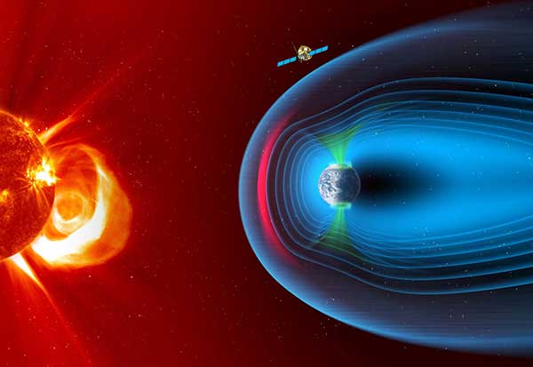
The European Space Agency has chosen Airbus to build the European component of the SMILE (Solar wind Magnetosphere Ionosphere Link Explorer) satellite.
SMILE will be the first joint satellite mission between the European Space Agency (ESA) and the Chinese Academy of Sciences (CAS), following on from the success of the Double Star/Tan Ce mission which flew between 2003 and 2008.
The objective of SMILE is to study and understand space weather. Specifically, it will look at the physics behind continuous interaction between particles in the solar wind and Earth’s magnetosphere, the magnetic shield that protects the existence of life in our planet.
Space weather can interfere with GNSS signals.
The mission is now entering a four-year period of manufacturing, testing and integration of the payload module and the platform. In launch configuration, these two components will form a 3.15-meter-high stack.
The spacecraft will have a mass of 2,200 kg and will travel in a highly elliptical orbit around the Earth. Its perigee will be at a distance of 5,000 km (from where it will download data to the Troll ground station in Antarctica and the CAS ground station in Sanya, China), while the apogee will be as far as 121,000 km (almost one third the distance to the Moon). At this vantage point the satellite will have a prolonged view of the Earth’s northern polar regions, to enable the boundary of the Earth’s magnetic field and the Northern Lights, or aurora borealis, to be imaged.
Payload in Madrid, platform in Shanghai. The payload module will be built at the Airbus site in Madrid, where the instruments will be integrated. The platform will be built in Shanghai. Both, the payload module and the platform will be integrated and tested at ESA’s European Space Research and Technology Centre facilities by a multinational team.
The science payload consists of four instruments:
The Soft X-ray Imager will obtain unique measurements of the regions where the solar wind impacts the magnetosphere.
The Ultra-Violet Imager will study the global distribution of the auroras.
The Light Ion Analyser will measure the energetic particles in the solar wind.
The Magnetometer will assess changes in the local magnetic field.
“Today, we are able to predict the weather on Earth; now it’s SMILE’s turn to help us understand space weather around the Earth and who knows? Probably one day, we will have enough data to be able to forecast dangerous solar storms that could disrupt our systems in space and on the ground,” said Fernando Varela, head of Airbus Space Systems in Spain. “We thank the Spanish Administration for their decisive and continued support to scientific missions.”
Other ESA missions, built by Airbus, such as Cluster that studied the Earth’s magnetosphere, and SOHO that studied the Sun, have already improved understanding of space weather.
Under the current plans, the spacecraft will be launched by a European Vega-C or Ariane 62 rocket in 2023.
Ensuring the freedom to continue innovating is vital to our global economy, job creation and ultimately to empowering the next generation of GPS-enabled applications.
GPS — it’s a household name and has come to benefit so many aspects of our day-to-day lives. Today across the globe, it is estimated that there are more than 3 billion GPS receivers in the marketplace. Included in this total are GPS receivers found in mobile phones, automobiles, airplanes, tractors, boats and high-precision surveying equipment, to name just a few examples. In the past decade alone, GPS applications like these have helped generate more than $1.2 trillion for the U.S. economy and millions of jobs.
So how did GPS become so ubiquitous? Thanks to the leadership of the United States Air Force, which maintains and operates the GPS constellation, and long-standing U.S. policy, which makes GPS available as a vital public resource, any private sector company can design and build a receiver capable of listening for these GPS signals, without seeking the government’s approval or paying user fees. This freedom to innovate is at the heart of why GPS has been so successful and continues to drive innovation across our economy.
With the freedom to innovate, GPS receiver manufacturers have developed a range of advanced technologies to address market needs from the simple to the highly complex. These technologies reflect the inherent functional and technical differences between radio communications services and a navigation service like GPS.
Huge range of technologies. GPS receiver innovations enable a receiver to listen for a GPS signal that is less than a millionth of a billionth of a watt, while simultaneously resisting interference that is 10,000 times greater. Whether the GPS receiver is found in a tiny smartwatch or a 20-ton tractor, what they have in common is the ability to convert a faint radio signal into what we most commonly recognize as our current location displayed as a blue dot. They do this remarkably well.
Today’s regulatory landscape also correctly recognizes that every GPS-enabled application has unique requirements driven by intended function, environment and design factors. For example, a GPS receiver used for synchronizing financial transactions has different demands from a GPS receiver found in an autonomous vehicle. The former focuses on timing while the latter needs precise positioning to help maintain lane-level guidance.
Similarly, high-precision surveying equipment capable of delivering centimeter-level accuracy will no doubt have different receiver and antenna requirements than those found in a typical smartphone. The freedom to innovate enables GPS receiver manufacturers to support this market differentiation.
GPS resiliency. With many of our nation’s key critical infrastructure sectors dependent on GPS, there has been increasing discussion in Washington about the resiliency of GPS. Some have specifically expressed concern that a GPS jamming or spoofing attack could disrupt these key services and have advocated for new requirements on GPS receivers.
To be clear, GPS jammers and spoofers are illegal devices, designed specifically to interfere with GPS signals, either blocking the signal outright or emitting a fake signal in order to falsify one’s location. In either scenario, this interference occurs within a localized area from a detectable source. So, the reality is that mandates won’t stop a malicious actor intent on illegally interfering with GPS or another wireless technology, but vigorous enforcement of U.S. federal law can.
It is also important to remember that the GPS satellites are a multi-use U.S. military-civilian asset, supporting the mission of our armed forces, and have therefore been built with the highest levels of security and redundancy. Any attempts to attack the GPS constellation risks impacting not just civil services but the military signal as well.
Mission-critical applications. When it comes to resiliency, open innovation enables GPS receiver manufacturers to work with mission-critical application providers to develop products designed to meet their specific requirements. Different categories of users can and should define and specify performance and resiliency requirements appropriate for their applications.
For example, the requirements for a military GPS receiver are much more demanding than those for the receiver in an IoT device that reports its position hourly or daily. A military GPS receiver will, therefore, be significantly more expensive than an IoT receiver. Conversely, those who deploy internet of things (IoT) receivers will require low price points to support ubiquitous applications.
GPS manufacturers and applications developers have responded to market requirements by providing new and innovative techniques for increasing resilience, including designing receivers capable of receiving signals from multiple GNSS systems. This is the best way to ensure resilience — via application-specific requirements that are driven by customers who are most knowledgeable about their needs, not by general regulations or government fiat.
Preserving signal access. At the same time, the government does have a responsibility to investigate and take the necessary enforcement action to preserve unhindered reception of GPS signals. Vigorous enforcement of federal law by the Federal Communications Commission (FCC) and other government agencies — which already prohibits the manufacture, importation, marketing, sale and operation of GPS jammers — can keep these illegal devices out of the hands of those seeking to disrupt GPS operations. Such enforcement is critical to protecting our military operations, aviation and other safety-of-life applications.
Over the past three decades, worldwide adoption of robust, innovative GPS receivers attests to the trust users have placed in GPS as the gold standard for availability, accuracy, reliability and resiliency. Ensuring the freedom to continue innovating is vital to our global economy, job creation and ultimately to empowering the next generation of GPS-enabled applications.
About the GPS Innovation Alliance
The GPS Innovation Alliance was founded by Deere & Company, Garmin International Inc. and Trimble Inc. The Alliance recognizes the ever-increasing importance of GPS and other GNSS technologies to the global economy and infrastructure and is firmly committed to furthering GPS innovation, creativity and entrepreneurship. The GPS Innovation Alliance seeks to protect, promote and enhance the use of GPS. For more information, visit www.gpsalliance.org or follow @GPS4Life.
J. David Grossman serves as executive director of the GPS Innovation Alliance (GPSIA), an organization dedicated to protecting, promoting and enhancing the use of GPS. Prior to joining GPSIA, Grossman spent nearly a decade in public service, including as chief of staff to FCC Commissioner Mignon Clyburn; legislative director and senior advisor for technology policy to Rep. Anna Eshoo of Silicon Valley; and as technology counsel to the U.S. House Small Business Committee under the leadership of Rep. Nydia Velázquez.
Grossman holds a Master’s Degree in Public Policy from George Mason University and a B.A. in Political Communication from George Washington University’s School of Media and Public Affairs.
The 28th edition of the European Navigation Conference (ENC 2020) will be held May 11-14 at the International Congress Center in Dresden, Germany.
The conference is hosted by the German Institute of Navigation (DGON). Because of the rapid development of analog and digital technologies, there is increasing progress in performance of GNSS.
The conference brings together scientists, engineers and international experts to discuss new ideas, latest research results, future developments and new applications. High-level presentations will allow each participant to receive an in-depth view on the current status of satellite navigation technology. Topics include:
GNSS Updates & Policies
GNSS Algorithms & Techniques
Resilience and Autonomy
Multi-Sensor & Data Fusion
Aviation & Marine Navigation
Space & Science Applications
Mobility and Transportation
Speakers. Keynote speakers will be Julia Klöckner, Federal Minister of Food and Agriculture, and Dr. Pascale Ehrenfreund, German Aerospace Center, chair of the Executive Board.
Expo. A technical exhibition provides an opportunity for companies, agencies and research institutions to display their offerings; it will be directly placed in the conference area.
Abstracts. The European Navigation Conference aims to provide a forum for both academic and industrial professionals in navigation topics from all over the world and to bring together academicians, researchers, engineers, system analysts, graduate and undergraduate students with government and non-government organizations to share and discuss both theoretical and practical knowledge. Experts are invited to submit outstanding and valuable original research papers and participate in the technical exhibition during the conference. The deadline for abstracts is Nov. 1, 2019.
About Dresden. The city of Dresden is located at the river Elbe and has a long and colorful history. Although Dresden is a relatively recent city of Slavic origin, it is well-known as the capital and royal residence for the Electors and Kings of Saxony, who for centuries furnished the city with cultural and artistic splendor. After the reunification process in 1989, Dresden has regained importance as one of the cultural, educational, political and economic centers of Germany and Europe.
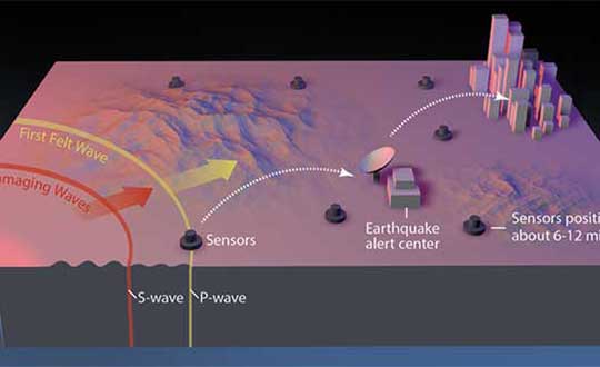
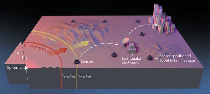
Previous research suggests that not until halfway through a rupture (90 seconds for a magnitude-9 quake) can magnitude be predicted. Geodetic GNSS data could bring this down to as little as 10 seconds — greatly extending and enhancing earthquake early warning systems.
How soon can we predict the magnitude of an earthquake?
Seismologists Diego Melgar of the University of Oregon and Gavin Hayes of the U.S. Geological Survey (USGS) in Golden, Colorado, tackled this question by chance while Melgar was writing code to simulate earthquakes to check the accuracy of Earthquake Early Warning systems in the Pacific Northwest.
He reached out to Hayes, who curates a database for the USGS that contains “source time functions,” which show how the seismic energy release changes through time as the earthquake ruptures.
As a rupture grows, the speed of growth changes, and source time function captures that change. Melgar and Hayes focused on the acceleration of the energy release in large (M>7) and great (M≥9) earthquakes, and found that acceleration wobbled between 2 and 5 seconds after the quakes began.
In February 2016, the USGS rolled out the second-generation ShakeAlert Earthquake Early Warning test system in California. The diagram shows how the system would operate. (Image: USGS)
However, with the approximately 250 M≥7 earthquakes in their database, they found that between 10 and 15 seconds after rupture began, these larger earthquakes started to behave similarly, and that behavior scales with their final magnitude, Hayes said. “In other words, the acceleration at 10 to 15 seconds is diagnostic of their final magnitude.”
Earthquake ruptures sputter along for about 10 seconds, after which the big ones accelerate, according to Melgar and Hayes. Three different source time function databases showed the same consistency.
Vertical movement near the source of large earthquakes can be between 3 and 5 meters, according to data from GNSS geodetic receivers. Analysis of near-source GNSS data from 12 M≥7 earthquakes showed that for the first 10 seconds after the first indication of an earthquake was recorded, the earthquakes made almost immeasurable movements. But between 10 and 15 seconds, the amount of vertical displacement began to rapidly diverge for the different magnitude groupings. By 20 to 25 seconds, the vertical movement was distinct.
Previous research indicated roughly half the source duration must pass before an accurate prediction could be made. Cutting the prediction time down to 15 seconds would be invaluable to earthquake early warning systems and tsunami prediction algorithms, where every second counts.
GNSS sensors are installed onshore across the globe, but the majority of megathrust earthquakes occur underwater. To integrate Melgar and Hayes’ findings effectively into earthquake early warning systems would require sensors installed along the seafloor, they noted. “You [would also] need to have fiber-optic cables from shore to the bottom of the ocean, winding around with sensors, and then eventually coming back on shore, and that’s not cheap,” Melgar said.
An additional 10 to 30 seconds of warning to a city or nuclear reactor of an imminent quake would have enormous benefits. But if the hypothesis is wrong, using it now would lead to a greater rate of false alarms and missed quakes, eroding the value of these warnings to society. Melgar and Hayes acknowledged their finding needs to be rigorously tested.
Summarized from Temblor’s website. The Temblor Android app and website provide earthquake, landslide, tsunami and flood information.
Citation
Tripathy-Lang A. (2019), “Can the size of a large earthquake be foretold just 10 seconds after it starts?”. Temblor, http://doi.org/10.32858/temblor.029
“Seen & Heard” is a monthly feature of GPS World magazine, traveling the world to capture interesting and unusual news stories involving the GNSS/PNT industry.
Photo: Nuro
Hey, R2, Where’s my pizza?
Domino’s pizza will start using Nuro’s R2 unmanned vehicles for delivery in Houston, Texas, later this year. Once customers have opted in, they can track the R2 vehicle via the Domino’s app and will be provided with a unique PIN code to unlock a compartment to get their pizza. Nuro is already at work in Houston delivering goods from dinner to dry cleaning.
Screenshot: BBC
Drone Attack
A BBC documentary has sent the drone industry into a tizzy. “Britain’s Next Air Disaster? Drones” begins with the December 2018 Gatwick Airport incident when two drones entering airport airspace led to a disruption of operations for three days. Dronemakers dislike the documentary’s thrust that drones are a threat to public safety and a tool for terrorists, while barely mentioning their positive contributions in fields such as search and rescue, plant inspections and agriculture.
Photo: Rawpixel.com/Shutterstock.com
NavIC Rising
The Indian Space Research Organisation is in talks with chipmakers Qualcomm and Broadcom to substitute GPS in Indian mobile phones with its own satellite system (NavIC). The Times of India noted that cellphones hold the biggest commercial potential for NavIC, with more than 650 million mobile users in India. ISRO and the Indian Air Force are also working to equip fighter jets with the navigation system, and commercial vehicles registered after April 1 are mandated to have NavIC trackers.
Photo: Monitum Pty Ltd.
Infrastructure sensors are Mthing
Internet of things (IoT) project Mthing is researching GNSS monitoring sensors to record near-real-time measurements of infrastructure construction. The 18-month project in Brisbane, Australia, aims to develop GNSS IoT sensors that will provide cost-efficient, constant and high-precision monitoring that will connect to cloud services and provide instant alerts. Mthing aims to produce low-cost sensors with broad market potential. The research team includes Queensland University of Technology, survey company Monitum, and the Innovative Manufacturing Cooperative Research Centre.
China’s National Reference Station Network. (Image: BeiDou)
A Russian law was approved July 26 that sets forth cooperation between Russia and China on using GLONASS and BeiDou for peaceful purposes.
According to the RosCosmos website, the law was approved at a meeting of the Council of Federation of the Federal Assembly of the Russian Federation. The law is officially named, “On ratification of the agreement between the Government of the Russian Federation and the Government of the People’s Republic of China on cooperation in the use of GLONASS and Beidou global navigation satellite systems for peaceful purposes.”
An intergovernmental agreement was signed on Nov. 7, 2018, in Beijing during the 23rd regular meeting of the heads of government of Russia and China. The agreement creates an institutional and legal framework for cooperation in the development and manufacture of civil navigation equipment using GLONASS and Beidou systems.
It also establishes cooperation in the development of Russian-Chinese standards for the application of navigation technologies using both systems — in particular, standards for the control and management of traffic flows across the Russian-Chinese border. The border is 4,200 kilometers (2,615.5 miles) long — world’s sixth-longest international border.
Under the agreement, the two countries plan to place in their own countries measuring stations for the other country’s GNSS, on a reciprocal basis.
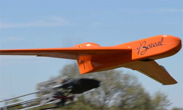
EGNSS improves positioning integrity and accuracy for the Boreal drone. (Photo: GSA)
News from the European GNSS Agency
The Skyopener project, co-financed by the European GNSS Agency (GSA), aims to pave the way toward increased use of remotely piloted aircraft system (RPAS) in civil applications.
The project has tested the benefits of multi-frequency GNSS and EGNOS in RPAS, revealing gains in availability, accuracy and robustness.
There is increasing demand to operate RPAS over long distances because of their potential for a wide range of civil applications. However, regulation regarding RPAS use in civil airspace does not yet allow beyond-visual-line-of-sight (BVLOS) operations, and remotely piloted aircraft are not allowed to fly in non-segregated civil airspace and are not yet widely used for civil and commercial applications.
This is something that Skyopener aims to change.
RPAS for civil applications. The project is developing operational processes that will reduce all categories of risks associated with RPAS and allow an air navigation service provider (ANSP) to manage very-low-level RPAS operations. Thanks to the benefits it offers in terms of improved integrity and positioning accuracy, EGNSS (Galileo and EGNOS) will play a central role in these processes.
Through these operational processes, Skyopener will contribute to the roadmap for the integration of civil RPAS into non-segregated airspace, which will have a huge impact on the service applications that can be offered by these aircraft.
“Systems that enable RPAS to fly safely, in compliance with regulations, will enable market access and significantly reduce the cost of insurance premiums for RPAS operators, making a wide range of RPAS applications more commercially attractive and widely used,” said Marc Pollina, CEO of Skyopener consortium member M3 Systems.
Excellent results. A test conducted by the project into the benefits of multi-frequency GNSS and EGNOS has delivered excellent results. The test found that the use of GPS and Galileo in L1/E1 and L5/E5 multi-frequency combinations provides improved availability, better accuracy and greater robustness against interference, as interference with one frequency band has no effect on the second.
What’s more, EGNOS helps meet increasingly stringent requirements for robust navigation, continuity, accuracy and availability — further complemented by Galileo’s multi-constellation capacity and integration with other sensors such as inertial or vision sensors.
The Boreal drone used in the project is a fixed-wing system that operates over a long range (more than 100 kilometers) in BVLOS, with EGNOS and Galileo enhancing navigation by improving positioning integrity and accuracy. In addition, the RPAS is equipped with a newly developed communication and navigation surveillance (CNS) system that combines use of GNSS, satcom and special security measures.
Essential GNSS. GNSS technologies are essential for RPAS. The primary need is obviously for navigation — the RPAS uses GNSS waypoints to follow the trajectory defined in its mission. However, GNSS also addresses other key needs, such as geofencing to ensure that the RPAS keeps within the mission parameters and surveillance to enable adequate tracking by the operator and civil aviation authority.
GNSS also enables high accuracy and, ultimately, automated landing and the geo-referencing of collected data. These benefits will increase in the future, with the Galileo authentication service reducing the risk of threats, and PPP data correction on E6 providing better geo-referencing.
Galileo’s Control Centre in Fucino is used to oversee the satellites’ navigation payloads and services. (Photo: ESA)
Global markets learned something important from the brown-out of Galileo signals over a week’s time in July: Life goes on without a hiccup in the absence of the European GNSS.
Very unfortunately for the backers and boosters of Galileo, this message will reverberate down through the years. If vital affairs proceed unaffected by Galileo’s travails, or triumphs for that matter, who needs it? The response, a shrug. I’m tempted to say a Gallic shrug, were it not that the Gauls, the French, are prime among the system’s boosters and backers.
I’m among that number as well. Galileo and I have known each other all our lives, all our professional lives. When I started on this magazine 19 years ago, the first story I edited was on Galileo’s public-private partnership.
Galileo then was just a collective gleam in several politicians’ and scientists’ eyes. Look how far it has come: 20 satellites flying in various operational or testing states.
The European GNSS Agency was very careful to point out during the crisis that Galileo is in its initial services phase. Its signals are available for use in combination with other GNSS and are not intended to provide a complete solution by themselves. This status is expressly designed to allow for “the detection of technical issues before the system becomes fully operational.”
So, it doesn’t count. Because, the game hasn’t really started yet. Right?
Not quite.
Because this episode occurred, it will be remembered. Because it lasted so long, it will be factored. Because the official announcements about it were so obscurantist, the system may find it more difficult to regain trust.
Of course a full, careful, in-depth investigation must take place before officially announcing what caused the debacle. But more than was said could surely have been said, during the crisis. A full week now, as of this writing, after the week-long outage concluded, we still have no indication as to which piece of ground equipment or software failed and why there wasn’t a smooth transition from the Italian to the German control station.
Redundancy was built into the system to preclude exactly such failures as this. Why didn’t redundancy work?
Transparency is a rhyming word that goes well with redundancy.
Trust — corporate confidence — is fundamental to installation in multi-GNSS chips, boards, modules, all manner of devices. Four systems compete for spots at a table that may comfortably fit only three. Even three could be a stretch.
GLONASS suffered a much shorter (11-hour) timing glitch in 2014, and has yet to climb back into the public-confidence ring.
Here’s a very public lesson in transparency: When the GPS satellite SVN49 failed rather spectacularly in 2009, the GPS Directorate was very forthcoming, almost embarrassingly so, about what happened and why. GPS never lost a step in the public’s and the industry’s eyes.