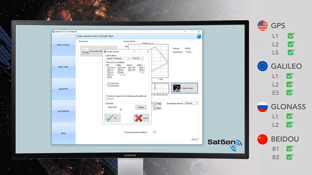
Racelogic Ltd. has released the latest update to its SatGen GNSS simulation software for PC, which now incorporates Galileo RF simulation.
Designed to create a GNSS RF I&Q or IF data file based on a user-generated trajectory file, the updated software can now accurately simulate the European Galileo GNSS satellite constellation alongside existing GPS, GLONASS and BeiDou RF signal generation.
The full range of Galileo frequencies that SatGen can simulate are Galileo E1 B/C, E5a, E5b and E6 B/C (see below for details).
SatGen 3.11.39 Galileo simulated RF frequencies
Galileo E1 B/C. Transmitted by all Galileo satellites on the E1 (1575.42 MHz) frequency, same as GPS L1. Standard precision Open Service signal consisting of Data component B and Pilot component C.
Galileo E5a. Transmitted by all Galileo satellites on the E5a (1176.45 MHz) frequency, same as GPS L5. Open Service signal consisting of Data component I with the F/NAV navigation message and Pilot component Q. Intended to be used together with E1 B/C to improve accuracy.
Galileo E5b. Transmitted by all Galileo satellites on the E5b (1207.14 MHz) frequency, same as BeiDou B2. Open Service signal consisting of Data component I with the I/NAV navigation message and Pilot component Q. Intended to be used together with E1 B/C to improve accuracy.
Galileo E6 B/C. Transmitted by all Galileo satellites on the E6 (1278.75 MHz) frequency. High accuracy Commercial Service signal consisting of Data component B and Pilot component C. Because the content of the C/NAV navigation message is encrypted, SatGen transmits a dummy navigation message, which should be accepted by all receivers.
“Given the vast improvements in navigation and timing that Galileo has brought to its global users, we extremely excited to be releasing a version of SatGen that allows engineers to generate Galileo-specific scenarios for their test procedures,” said Mark Sampson, LabSat product manager.
Other changes to the software include various user interface tweaks, performance optimization and fixes.
For more information on SatGen, contact Katie Harland or call Racelogic LabSat at +44 1280 823 803.
By Fabio Dovis, A. Minetto, A. Nardin, Politecnico di Torino Department of Electronics and Telecommunications, E. Falletti, D. Margaria, M. Nicola, M. Vannucchi, LINKS foundation
Following the issue by the Galileo Service Center of the Notice Advisory to Galileo Users (NAGU) reporting Service Outage for all the Galileo satellites, as curious Galileo users our team of researchers of the NavSAS group started an independent investigation of the received signals in space (SISs).
In fact, we observed that a commercial ublox EVK-M8T receiver, forced to use Galileo-only satellites, provided a “no-fix” indication. Three Galileo-enabled smartphones, the Xiaomi MI 8, Huawei P 10 and Samsung Galaxy S8, which use assistance from the cellular network, were also not providing a Galileo-based position solution, considering the Galileo satellites as “not usable.”
However, the investigation started exploiting our in-house developed software receiver NGene, that was used in the past for similar monitoring of the GNSS signals, for example at the time of the transmission of the first IOV Galileo satellites in 2012, and the transmission of anomalous GPS signals from SVN49 in 2009. Monitoring the Galileo SISs, which were usable until the day before, we found that they were still correctly trackable, with normal power levels and Doppler profiles within feasible limits.
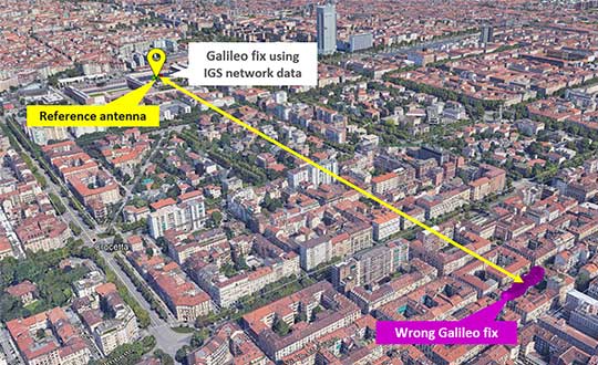
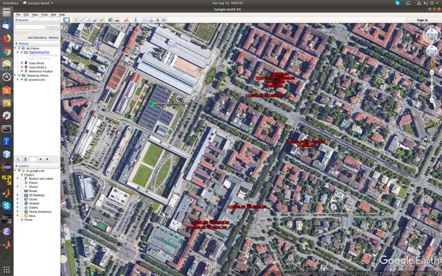
At the time of the first analysis, seven satellites were visible in the sky over Torino, Italy. Figure 1 reports a screenshot of the positions computed by means of NGene between 07:14:54 and 07:24:54 UTC on July 15, plotted on Google Earth. The position estimated using the Galileo-only satellite or hybrid GPS-Galileo solutions (red dots) showed errors on the order of 500 meters or even more. The georeferenced antenna position is depicted by the green pin.
Figure 1. Misplaced Galileo and GPS+Galileo solutions. (Screenshot: Politecnico di Torino and LINKS Foundation)
The monitoring of the status flags taken from the Galileo E1B I/NAV message showed that the SIS was marked as “healthy” for all the visible PRNs apart the number 14, which is known to be “not usable” for a long time. The Signal in Space Accuracy Index (SISA) was set to 109, which is an acceptable prediction of the minimum standard deviation of an overbound of the SIS error.
According to the Galileo Open Service, Service Definition Document (OS SDD, issued 1.1, May 2019), a SIS “Healthy” means that the SIS is expected to meet the Minimum Performance Level and “a navigation solution obtained with Galileo SIS is expected to meet the Minimum Performance Levels reported in the Galileo OS SDD only if receivers comply with the assumptions reported in Section 2.4, including the use of navigation parameters within their broadcast period.”
In fact, the document specifies that “The navigation solution is expected to meet the Minimum Performance Levels only if receivers do not use navigation parameters beyond their broadcast period. The maximum nominal broadcast period of a healthy navigation message data set is currently 4 hours.”
The check of the nominal broadcast period was bypassed in our software receiver, which is indented as a research tool and not a commercial product as the one mentioned above, so that we were still able to obtain a GPS + Galileo PVT solution, since this check looked to be the only discrimination factor to validate and thus exclude the computed solution.
On July 17, the SISA flag was changed to 255: according to the OS SDD, the accuracy status was “No Accuracy Prediction Available (NAPA).” This means that the status of the broadcast SIS must be intended as “Marginal.” In this condition the EVK-M8T restarted to provide Galileo-based fixes, while the Xiaomi Mi8 Pro smartphone still excluded the Galileo satellites from its PVT fix.
The analysis of the decoded Galileo navigation message led to the conclusion that ephemerides and clock correction data were last updated around 19:00 UTC of 1July 16. For example, PRN 3 and 15 changed Issue Of Data (IOD) from 958 to 17 at Galileo Signal Time TOW 241855, which corresponds to 19:01:25.
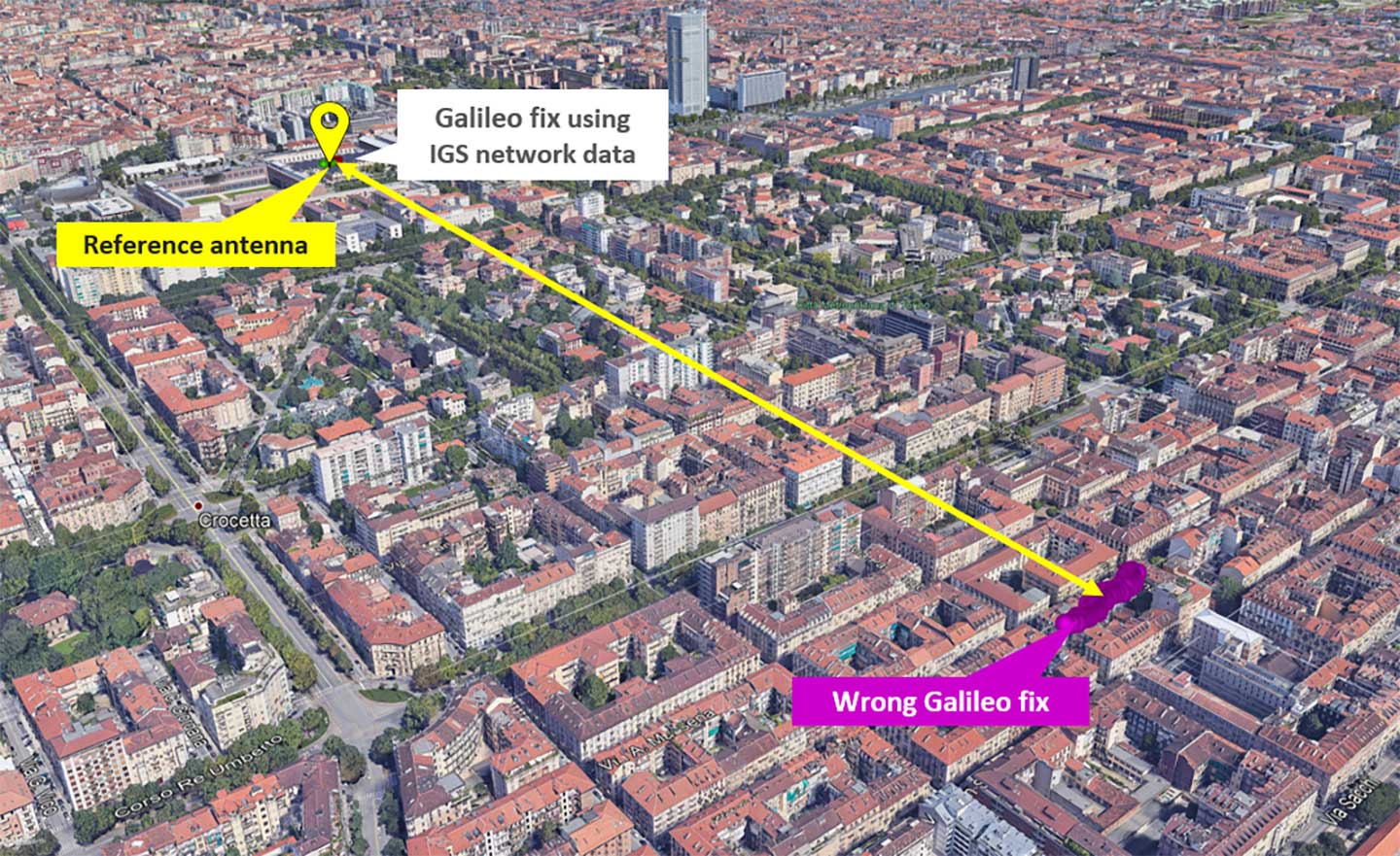
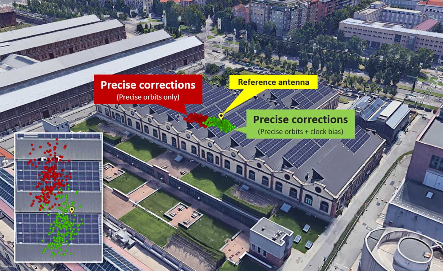
As a final check, we used external ephemerides to process the Galileo signals during the “system outage.” Figure 2 and Figure 3 show different navigation solutions obtained by processing a data collection taken on July 12 at 10.00 UTC (12.00 Local time). The purple dots indicate few fixes obtained by demodulating the navigation message transmitted by the Galileo satellites and show a remarkable bias with regard to the reference antenna location.
Figure 2. Comparison of Galileo-only solutions using Navigation message ephemeris data and IGS ephemeris. (Image: Politecnico di Torino and LINKS Foundation)Figure 3. Zoom on the Galileo-only positions obtained by using IGS data.(Image: Politecnico di Torino and LINKS Foundation)
In Figure 3, the green dots are the navigation solution obtained correcting the satellites positions according to precise orbits data and clock drift provided by the IGS network. The fix is a simple code based Least Mean Square solution without smoothing of the pseudoranges.
The two results were obtained by processing the same satellites signals, thus proving that their quality was still sufficient to get an acceptable positioning solution during the Galileo service outage period. This brought us to the conclusion that, during the outage, only the ephemerides updates were affected by problems, while the other SIS components appeared sound and usable.
Galileo Initial Services have been restored after a week-long signal outage, according to a statement released on July 18 by the European GNSS Agency (GSA).
“Commercial users can already see signs of recovery of the Galileo navigation and timing services…although some fluctuations may be experienced until further notice.”
After a signal outage that began on July 11, efforts to restore services reportedly found a malfunction in the calculation of time and orbit predictions (ephemeris).
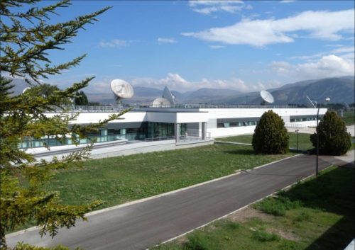
Why the error affected both Precise Timing Facilities (PTFs) within the Galileo ground control system, at Fucino in Italy and Oberpfaffenhoffen in Germany, has not been explained. System redundancy in the form of such doubled facilities was meant to prevent such breakdowns.
The GSA statement continues:
“Galileo Initial Services have now been restored. Commercial users can already see signs of recovery of the Galileo navigation and timing services, although some fluctuations may be experienced until further notice.
“The technical incident originated by an equipment malfunction in the Galileo ground infrastructure, affecting the calculation of time and orbit predictions, and which are used to compute the navigation message. The malfunction affected different elements on the ground facilities.
“A team composed of GSA experts, industry, ESA and Commission, worked together 24/7 to address the incident. The team is monitoring the quality of Galileo services to restore Galileo timing and navigation services at their nominal levels.
“We will set an Independent Inquiry Board to identify the root causes of the major incident. This will allow the Commission, as the programme manager, together with the EU Agency GSA to draw lessons for the management of an operational system with several millions of users worldwide.”
The full statement, including links to previously issued Notice Advisories to Galileo Users (NAGUs) is available here on the GSA website.
The Galileo signal outage, ongoing since Thursday, July 11, has been attributed to a problem with the system’s ground infrastructure, according to an announcement by the European GNSS Agency (GSA). “Experts are working to restore the situation as soon as possible,” states the GSA. “An Anomaly Review Board has been immediately set up to analyze the exact root cause and to implement recovery actions.”
No update has appeared at this time as to when service will resume.
[Photo: Galileo’s Ground Mission Segment in the Fucino Control Centre in Italy oversees Galileo navigation services and satellite payload operations. Photo: Telespazio.]
The announcement points out that Galileo is currently in its initial services phase, wherein its signals are available for use in combination with other GNSS and do not provide a complete solution in and of themselves. This status is expressly designed to allow for “the detection of technical issues before the system becomes fully operational,” according to the GSA.
Indeed, experiments undertaken with Galileo-capable smartphones found that these devices excluded Galileo participation in their position solution. This is likely true of commercial receivers as well, which employ sophisticated signal checks as well as following system notice advisories, which have been issued in this case.
“For each constellation, there is a defined maximum age of ephemeris that is considered valid,” explained Sandy Kennedy, vice president, innovation at NovAtel. “Once an ephemeris is too old, our receiver will deem it invalid. Measurements made to satellites without a valid ephemeris are not allowed to contribute to the PVT solution. We noticed the missing Galileo ephemeris within 3 hours of the broadcast stopping. It wasn’t the NAGU that alerted us to the problem.”
The company posted a bulletin to its website on Friday afternoon, July 12, stating: “During this time [without ephemeris], NovAtel receivers will continue to track Galileo signals, but without a valid ephemeris, the signals are not included in the position solution. . . . Once the Galileo service returns to normal and transmits ephemeris information, NovAtel receivers will revert to normal operation.”
The experiments mentioned above were conducted by the Navigation Signal Analysis and Simulation (NavSAS) Group at Fondazione LINKS (formerly the Istituto Superiore Mario Boella) and the Politecnico di Torino. In their account they state that, using a software receiver that tracked the Galileo signals in space (SISs), “the position solution computed using both the GPS and Galileo constellation is affected by errors on the order of 500 meters or even more.”
In a detailed technical analysis, the NavSAS Group found three other curious and unexpected aspects of the situation, all explored and illustrated at the Group’s posting.
The entire Galileo system suffered an unexpected and hitherto unexplained signal outage, beginning on Thursday, July 11, at 1 p.m. Central European Time. At about that time, users noticed that all ephemeris stopped broadcasting, and then a Notice Advice to Galileo Users (NAGU) appeared:
NAGU Subject: Service Degradation
Satellite Affected: ALL
Event Description: Until further notices, users may experience service degradation on all Galileo satellites.s this means that the signals may not be available nor meet the minimum performance levels defined in the service definition documents and should be employed at users’ own risk. The nominal service will be resumed as soon as possible.”
The signal outage has persisted for more than two days (as of Saturday) and as yet no word has emerged as to the cause or duration of the signal outage.
On the evening of July 13, a second NAGU appeared, saying simply that “Until further notice, users experience a service outage. the signals are not to be used.”
On the European GNSS Service Centre’s constellation status page, 22 Galileo satellites are listed as “Not Usable” with cause being “Service Outage.”
[Photo: Galileo Control Center, Oberpfaffenhofen. Photo: GSA]
GPS could be used to pilot in and around lunar orbit during future Artemis missions.
A team at NASA is developing a special receiver that would be able to pick up location signals provided by the 24 to 32 operational GPS satellites. Such a capability could soon also provide navigational solutions to astronauts and ground controllers operating the Orion spacecraft, the Gateway in orbit around the Moon and lunar surface missions.
The advanced GPS receiver would be paired with precise mapping data to help astronauts track their locations in space between the Earth and the Moon, or on the lunar surface.
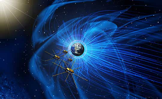
Artist’s concept of NASA’s Magnetospheric Multiscale mission consists of four identically equipped observatories that rely on Navigator GPS to maintain an exacting orbit that is at its highest point nearly halfway to the Moon. (Image: NASA)
Navigation services near the Moon have historically been provided by NASA’s communications networks. The GPS network could help ease the load on NASA’s networks, freeing up that bandwidth for other data transmission.
“What we’re trying to do is use existing infrastructure for navigational purposes, instead of building new infrastructure around the Moon,” said engineer and principal investigator Munther Hassouneh at Goddard Space Flight Center in Greenbelt, Maryland.
NASA has been working to extend GPS-based navigation to high altitudes, above the orbit of the GPS satellites, for more than a decade. The agency now believes its use at the Moon, which is about 250,000 miles from Earth, can be done.
“We’re using infrastructure that was built for surface navigation on Earth for applications beyond Earth,” said Jason Mitchell, chief technologist for Goddard’s Mission Engineering and Systems Analysis Division. “Its use for higher altitude navigation has now been firmly established with the success of missions like Magnetospheric Multiscale mission (MMS) and the Geostationary Operational Environmental Satellites (GOES). In fact, with MMS, we’re already nearly halfway to the Moon.”
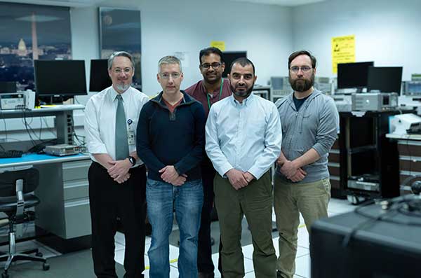
Navigator GPS
The team developing a GPS receiver for use in and around lunar orbit (from left): Jason Mitchell, Luke Winternitz, Luke Thomas, Munther Hassouneh and Sam Price. (Photo: NASA/T. Mickal)
The lunar GPS receiver is based on the Goddard-developed Navigator GPS, which engineers began developing in the early 2000s specifically for NASA’s MMS mission, the first-ever mission to study how the Sun’s and Earth’s magnetic fields connect and disconnect. The goal was to build a spacecraft-based receiver and associated algorithms that could quickly acquire and track GPS radio waves even in weak-signal areas. Navigator is now considered an enabling technology for MMS.
Without Navigator GPS, the four identically equipped MMS spacecraft couldn’t fly in their tight formation in an orbit that reaches as far as 115,000 miles from Earth’s center — far above the GPS constellation and about halfway to the Moon.
“NASA has been pushing high-altitude GPS technology for years,” said Luke Winternitz, the MMS Navigator receiver system architect. “GPS around the Moon is the next frontier.”Extending the use of GPS to the Moon will require some enhancements over MMS’s onboard GPS system, including a high-gain antenna, an enhanced clock and updated electronics.
“Goddard’s IRAD (Internal Research and Development) program has positioned us to solve some of the problems associated with using GPS in and around the Moon,” Mitchell said, adding that a smaller, more robust GPS receiver could also support the navigational needs of SmallSats, including a new SmallSat platform Goddard engineers are now developing.
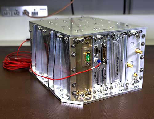
Building on NavCube
NavCube, which will be tested aboard the International Space Station later this year, is being used as a baseline for a lunar GPS receiver. (Photo: NASA/W. Hrybyk)
The team’s current lunar GPS receiver concept is based on NavCube, a new capability developed from the merger of MMS’s Navigator GPS and SpaceCube, a reconfigurable, very fast flight computer platform. The more powerful NavCube, developed with IRAD support, was recently launched to the International Space Station where it is expected to employ its enhanced ability to process GPS signals as part of a demonstration of X-ray communications in space.
The GPS processing power of NavCube combined with a receiver for lunar distances should provide the capabilities needed to use GPS at the Moon. Earlier this year, the team simulated the performance of the lunar GPS receiver and found promising results. By the end of this year, the team plans to complete the lunar NavCube hardware prototype and explore options for a flight demonstration.
“NASA and our partners are returning to the Moon for good,” Mitchell said. “NASA will need navigation capabilities such as this for a sustainable presence at the Moon, and we’re developing enabling technologies to make it happen.”
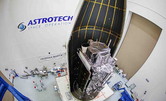
The second next-generation GPS III satellite — nicknamed “Magellan” by the U.S. Air Force — is encapsulated and ready for its planned July 25 launch.
On June 26, Lockheed Martin Space and United Launch Alliance (ULA) technicians completed encapsulating GPS III Space Vehicle 02 (GPS III SV02) in its launch fairings at the company’s Astrotech Space Operations facility, where the satellite has undergone pre-launch processing and fueling since its March 19 arrival in Florida. This final step enclosed GPS III SV02 in a protective, aerodynamic, nose-cone shell.
In the coming days, the enclosed GPS III SV02 satellite will be mounted to a ULA Delta IV rocket for launch. The current window for launch on July 25 opens at 10:55 a.m. ET.
“GPS III SV02 is launching just a brisk seven months after the nation’s first GPS III satellite lifted off back in December. The first satellite’s performance during on-orbit testing has exceeded expectations,” said Johnathon Caldwell, Lockheed Martin’s vice president for Navigation Systems. “We are excited to deploy more GPS III satellites so this new technology and capabilities can be distributed constellation-wide.”
GPS III satellite production and launch cadence is picking up. On May 27, the Air Force declared the next GPS III satellite, GPS III SV03, available for launch, pending an official launch date.
“More GPS III satellites are coming. If you looked at our production line back in Denver today you would see GPS III space vehicles 04, 05 and 06 already fully-assembled and in various stages of testing. And space vehicles 07 and 08 are being built up at the component assembly level now,” Caldwell added. “It is a smooth, efficient, methodical process.”
Lockheed Martin is under contract to develop and build up to 32 GPS III/IIIF satellites for the Air Force. GPS III will deliver three times better accuracy and provide up to eight times improved anti-jamming capabilities. GPS III’s new L1C civil signal will make it the first GPS satellite to be interoperable with other international global navigation satellite systems, like Galileo.
Additional GPS IIIF capabilities will begin being added with the 11th satellite. These will include a fully-digital navigation payload, a Regional Military Protection capability, an accuracy-enhancing laser retroreflector array, and a search-and-rescue payload.
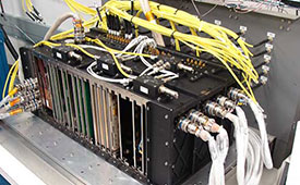
The Harris-supplied navigation payload before integration into the second GPS III SV. (Photo: Harris)
L3Harris Technologies announced the successful completion of the all-stock merger between Harris Corporation and L3 Technologies on June 29. Headquartered in Melbourne, Florida, L3Harris becomes the sixth largest defense company in the U.S., and a top 10 defense company worldwide, with approximately $17 billion in revenue and 50,000 employees, including 20,000 engineers and scientists.
Both companies have long been dominant presences in the U.S. GPS industry: Harris as a provider of the GPS satellite navigation payloads and geospatial intelligence software products, and L3 as a provider of military GPS user equipment and guided munitions. Both companies supply a wide range of other geospatially-related products as well.
L3Harris has organized its operating businesses into four segments to best meet customers’ mission requirements and leverage the combined company’s broad technical capabilities:
Integrated Mission Systems — headquartered in Palm Bay, Florida, with approximately $4.9 billion in revenue. Includes intelligence, surveillance and reconnaissance; advanced electro optical and infrared solutions; and maritime power and navigation
Space and Airborne Systems — headquartered in Palm Bay, Florida, with approximately $4.0 billion in revenue. Includes space payloads, sensors and full-mission solutions; classified intelligence and cyber defense; avionics; and electronic warfare
Communication Systems — headquartered in Rochester, New York, with approximately $3.8 billion in revenue. Includes tactical communications; broadband communications; night vision; and public safety
Aviation Systems — headquartered in Arlington, Texas, with approximately $3.8 billion in revenue. Includes defense aviation products; security, detection and other commercial aviation products; air traffic management; and commercial and military pilot training
Shares of Harris common stock, which traded on the NYSE under the ticker symbol “HRS,” began trading on July 2 under the ticker symbol “LHX.” L3 Technologies shares ceased trading upon market close on June 28 and have converted into 1.3 L3Harris shares for each L3 share.
The merger comes at approximately the same time that two other leading GPS companies, Raytheon and United Technologies, itself a merger including the former Rockwell Collins, now Collins Aerospace, also merged.
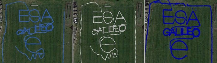
To test the accuracy of the competing satnav smartphone apps, the words ESA and Galileo were traced along ESTEC’s football field. The left side uses single-frequency GPS and Galileo signals, the center uses dual-frequency signals from the two constellations while the right is with precise corrections. The word “ESA” is 15 meters high, while “Galileo” is 7 meters high. (Photos: ESA)
News from the European Space Agency
Europe’s students and young researchers were challenged to design a smartphone app to take advantage of Galileo’s dual-frequency signals. The winning entries should soon be available to the public.
Run by ESA in collaboration with the European Global Navigation Satellite Systems Agency — GSA — plus the European Commission with the support of Google, a total of five teams made it to the final, which took place at ESA’s ESTEC technical heart in the Netherlands.
Following on from last year’s inaugural competition — which has already resulted in the winning app becoming publicly available — this year’s event challenged teams to make use of the dual-frequency capability of the latest smartphones running Android 8.0, including and computing dual-frequency positioning solutions from satnav signals to compare them with their single frequency equivalents. The competition slogan was “Galileo give mE5,” referring to Galileo’s dual E1 and E5 frequencies.
“Galileo give mE5”
The objective of the competition was to reach meter accuracy or less worldwide in unobscured sky, while allowing the user to select Galileo-only positioning, GPS-only positioning and the combination of both on a simultaneous basis, with the potential to include other satnav constellations in turn.
The winner was selected based on technical checks and a jury’s vote. Separate awards were also given to the most innovative app and the winner of a public vote.
The multinational O ThiSaVRoS team — named after the Greek word for treasure — developed the “GNSS Android-based Dual Frequency Iono-estimating Precise Point Positioning” or GADIP3 app.
The multinational ‘O ThiSaVRoS’ team – named after the Greek word for treasure – developed the ‘GNSS Android-based Dual Frequency Iono-estimating Precise Point Positioning’ or GADIP 3 app, winning the ESA-EC-GSA Galileo smartphone app competition 2019. (Photo: ESA)
Winners
The app allows users to perform reliable positioning fixes in real time — selecting which constellations to employ and a choice of single or dual frequency signals — while advanced users can modify the way the positioning is performed, and log all available data for follow-up analysis.
“Our mission goal is to provide precise positioning to everyone,” explained team coordinator Lotfi Massarweh. The O ThiSaVRoS team performed analysis on more than 120 hours of data from stationary, pedestrian and mobile testing to come up with a pre-processing approach involving rejection of signals from low elevation and under a specific signal-to-noise ratio.
The five-person team hail from China, Greece, Italy and Spain, studying at Portugal’s Instituto Superior Técnico Lisboa, Delft University of Technology in the Netherlands, Germany’s Leibniz Universität Hannover and the Universities of Bath and Nottingham in the UK. They worked remotely to develop and test the app over the previous six months.
NavGate allows geo-tagging in augmented reality
The NavGate smartphone app allows the sharing of geo-tags in augmented reality via the phone’s camera, as well as on maps. (Image: ESA)
As their app’s name suggests, O ThiSaVRoS hope to achieve precise point positioning in future, made possible by dual-frequency signal availability, to come close to single-metre-scale precision.
Second place went to the ESTEC-based Team GNSS Tonic’s NavGate app — aimed at bringing people together socially to interesting locations. Users can tag sites of interest to be seen by other people, with the resulting geotags viewable for others either on a map or else directly in augmented reality through their phone’s camera. NavGate could potentially be used for everything from sharing dining recommendations to fishing spots, or meeting up with people during an evening out.
The third prize to the Step with GNSS app by the Romania-based Space Walkers Team, designed to gather data on the paths of users walking outdoors. This game based app is backed up by a server application collecting data from the app users and analysing GNSS performance worldwide or regionally.
Single versus dual frequency
The winner of both the public vote and the most innovative app award went to Universitat Autònoma de Barcelona’s Inari Team and their Inari app.
Inari allows users to select various positioning modes or customise their own, selecting which algorithms and which corrections should be employed as well as specifying constellations and signal frequency. The app can also highlight jamming or spoofing that might be influencing the positioning accuracy.
ESA’s technical evaluation team performed tests of the competing apps in the days running up to the final, including tracing out ESA GALILEO as accurately as possible across the establishment’s football field.
The speaker of the jury, Frank van Diggelen from Google, congratulated the teams on their efforts. “Dual frequency on smartphones is a quite new development, and you really are pioneers in this. The manufacturers are still trying to get things right, and you’re helping them do that bit better. Doing anything for the first time is hard but it’s good to be first, so congratulations for that,” he said.
Galileo smartphone app competition final
The receiver chipsets inside smartphones routinely make use of Galileo in combination with several other satnav constellations — the U.S. GPS, Russian Glonass and Chinese BeiDou. These chipsets function in ‘black box’ style, making the resulting positioning fixes accessible to users, but without giving any option to the user to select which constellation to employ — or information on Galileo’s particular contribution to the phone’s overall positioning performance.
However, in newer Android smartphones it has become possible to access the raw signal measurements used to compute position, opening the door to the development of applications where the user can indeed select which constellations to employ.
The very latest models also allow the use of dual satnav frequencies, giving a major boost to positioning precision. The higher chip rate of the additional frequency allows the chipset to compensate for signal propagation errors from the signals’ journey through the ionosphere — the electrically active outer layer of atmosphere — and reduces false ‘multipath’ detections caused by signals reflecting off buildings.
Photo: Ministry of Defense of the Russian Federation
Israeli security officials publicly accused Russia of disrupting and spoofing GPS signal reception in Israeli airspace throughout the month of June. The electronic warfare at which Russia is known to be adept was reportedly traced to the Khmeimim Air Base in Syria, where Russia maintains and actively flies a large number of warplanes on behalf of the Syrian government. The base is approximately about 350 kilometers (217 miles) north of Ben Gurion, so if the accusation is true, fairly powerful equipment is behind the attack.
Both Israeli and other-nationality airline pilots have reported interruptions in GPS reception during take-off and landing at Tel Aviv’s Ben Gurion International Airport. The Israeli Airline Pilots Association labeled the interruptions a spoofing attack, causing airplane receivers to report false positions.
The International Federation of Air Line Pilots’ Associations issued a Notice to Airmen: “GPS signal loss affects RNAV arrivals and departures and may create numerous alerts for systems that rely on internal position accuracy. Flight Crews should be aware of the potential risk, avoid distractions, and plan for alternative procedures as necessary.”
Pilots have since for the most part relied on Instrument Landing System, a precision runway approach aid based on two radio beams which together with both vertical and horizontal guidance during an approach to land at Ben Gurion International Airport.
The Israeli Airports Authority stated that the GPS attacks affected only airborne crews and not terrestrial navigation systems, and that they occur only during daytime.
The Russian ambassador to Israel has denied the accusations.
In April, a U.S. research institute, the Center for Advanced Defense Studies, documented more than 10,000 separate incidents of GPS disruption on Russian soil, in northern Scandinavia and in the Middle East between February 2016 and November 2018. It said Russia was “pioneering” the technique to “protect and promote its strategic interests.” GPS World summarized the report here, stating that “The Russian Federation is growing and actively nurturing a comparative advantage in the targeted use and development of GNSS spoofing capabilities to achieve tactical and strategic objectives at home and abroad.”
Tie-in with Iran Tensions. Meanwhile the Helsinki Times reported that researchers at the Finnish Geodetic Institute noticed unusual power variations in the GPS signal on June 20 and 21: “an increase of up to 10dBHz in the carrier-to-noise ratio readings comparing with the usual daily values.” Normally the variations are between -0.5 and 0.5 dBHz.
The same findings were communicated to the research community by Peter Steigenberger, senior scientist at the German Aerospace Center, DLR:
“Based on carrier-to-noise density ratio observations (C/N0) of IGS receivers, we observed global flex power operations on June 20 and 21, 2019. Flex power started subsequently for all healthy Block IIR-M and IIF satellites on June 20 between 15:18 and 17:49 UTC. C/N0 of the P(Y)-code tracking increased by roughly 10 dB for all healthy Block IIR-M and IIF satellites whereas C/N0 of the C/A-code decreased by about 2-3 dB for the healthy IIR-M satellites only. The changes in power levels are similar to flex power mode III discussed in “Steigenberger P, Thölert S, Montenbruck O. (2019) Flex power on GPS Block IIR-M and IIF, GPS Solutions, doi:10.1007/s10291-018-0797-8″. All satellites returned to normal power levels on June 21 between 6:00 and 10:00 UTC.”
On June 20, a US military drone was downed down by Iranian missiles. On June 21 President Trump tweeted that he had called off a dawn attack on Iran that day.
Whether the spoofing affecting Israeli airspace has any connection to building tensions 1,500 kilometers to the east is unknown.
The GPS Directorate has released updates to the below Interface Control Documents (ICD). ICDs are the formal means of establishing, defining, and controlling interfaces and for documenting detailed interface design definitions for the GPS program.
Updated Documents
IS-GPS-200: Navstar GPS Space Segment/Navigation User Interfaces
IS-GPS-705: Navstar GPS Space Segment/User Segment L5 Interface
IS-GPS-800: Navstar GPS Space Segment/User Segment L1C Interface
ICD-GPS-240: Navstar GPS Control Segment to User Support Community Interface
ICD-GPS-870: Navstar Next Generation GPS Control Segment (OCX) to User Support Community Interface
Download or view the updated ICDs at GPS.gov or NAVCEN.
59th CGSIC Meeting Set for September
The U.S. Department of Transportation (DOT) and the Coast Guard Navigation Center (NAVCEN) have announced plans for the 59th meeting of the Civil GPS Service Interface Committee (CGSIC).
The meeting will take place Sept. 16-17 at the Hyatt Regency Miami in Miami, Florida, in conjunction with the Institute of Navigation’s ION GNSS+ 2019 conference.
CGSIC meetings are free and open to the public. Subcommittees of the CGSIC for Timing, International Information, and Survey, Mapping, and Geosciences will hold meetings Sept. 16, and a summary of these meetings will be presented to the CGSIC plenary session Sept. 17.
The meeting will include important briefings on the status of ongoing GPS programs and a keynote address by Diana Furchtgott-Roth, deputy assistant secretary, Office of the Assistant Secretary for Research and Technology, U.S. Department of Transportation.
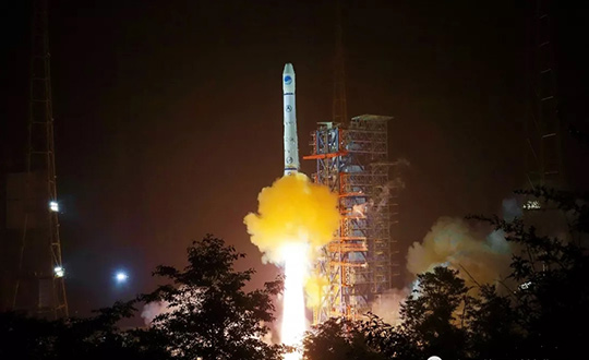
Seven-ninths of the way there! The 21st satellite of the BeiDou-3 global constellation, destined to number 27 upon completion, successfully launched from Xichang on June 24. Once in final orbit and commissioned, it will become the second of three planned inclined geosynchronous orbit (IGSO) satellites, traipsing in figure-eight loops across the skies above China and neighbors in the Asia-Pacific region.
The IGSO trio will play a key role in the expansion of BeiDou-3 from a regional to a global system, in that they may afford the Asia-Pacific region greater BeiDou-derived accuracy and availability — the so-called “optimized coverage” — than will be accessible to users of the constellation in other areas of the world.
The new satellite, like others of its latest generation, will establish inter-satellite ranging links, and carries new-gun rubidium atomic clocks and passive hydrogen maser clocks. It weighs 450 kg, a gain over previous generations, with a phased array antenna for navigation signals, a laser retroreflector and deployable S/L-band and C-band antennas.
While BeiDou-3 has widespread applications in construction, transportation, fishing, power grid, disaster response, public security, smart cities and more, it will also bring increased capability — and independence from GPS — to the People’s Liberation Army. At 2 million strong with modernizing equipment, this is a force to be reckoned with in an increasingly unsettled region, with China actively pursuing numerous territorial disputes.
BeiDou-3 is migrating its civil or B1 signal from 1561.098 MHz to 1575.42 MHz, the same as the GPS L1 and Galileo E1, and changing from a quadrature phase shift keying modulation to a multiplexed binary offset carrier modulation similar to Galileos E1 and the pending GPS L1C.