The meeting will be open to the public up to the seating capacity of the room. Visitors will be requested to sign a visitor’s register.
The agenda for the meeting includes the following topics:
Examine methods to protect, toughen and augment (PTA) access to GPS/GNSS services in key domains for multiple user sectors.
Examine emerging trends and requirements for PNT services in U.S. and international fora through PNT Advisory Board technical assessments, including backup services for terrestrial, maritime, aviation and space users.
Update on U.S. Space-Based PNT Policy and GPS modernization.
Explore opportunities for enhancing the interoperability of GPS with other emerging international GNSS.
Prioritize current and planned GPS capabilities and services while assessing future PNT architecture alternatives with a focus on affordability.
Assess economic impacts of GPS/GNSS on the United States and in select international regions, with a consideration towards effects of potential PNT service disruptions if radio spectrum interference is introduced.
Review the potential benefits, perceived vulnerabilities, and any proposed regulatory constraints to accessing foreign Radio Navigation Satellite Service (RNSS) signals in the United States and subsequent impacts on multi-GNSS receiver markets.
Meeting times are 8:30 a.m. to 5:30 p.m. Eastern Time on Thursday, June 6; and 9 a.m. to 1 p.m. ET on Friday, June 7.
Meeting address:
Westin Hotel Alexandria Old Town
400 Courthouse Square
Alexandria, VA 22314
Full details on the meeting can be found in the Federal Register Notice. For more information, contact James J. Miller, designated federal officer, Human Exploration and Operations Mission Directorate, NASA Headquarters, Washington, DC 20546, (202) 358-4417, fax (202) 358-4297, or [email protected].
In February I had the privilege of addressing the European Space Agency’s (ESA’s) Navigation Days conference in the Netherlands. An internal ESA event, Navigation Days gathers engineering staff from centers in several countries to discuss the present and future of their endeavors.
Since most of the audience had been “bathing” in Galileo, EGNOS and the evolution of both systems for many years, the Director of Navigation and the Galileo Project Manager thought it would be interesting for all to have an “outsider” perspective and opinions on Galileo and the European GNSS position in the world.
Though my half-hour talk ranged freely, and perhaps somewhat wildly, across many sectors and subjects, it had two main foci: the fundamental differences between Galileo and the three other GNSS, and the future portended by those differences. A future column here will address the latter, that is, the future. At present, the present distinctions.
To me, they distill down to three elements: active stimulus of market development, well-funded research into new applications, and — actually the foundation stone of the afore two — democratically elected governments representing citizenry with altruistic values: a strong desire for the common good, thoughtful regulation, intertwined diversity and open borders.
In sum, Galileo’s strength is the strength of the European Union.
“Active stimulus of market development, well-funded research into new applications, and citizenry with altruistic values.”
For example, the Horizon 2020 framework program offers €80 billion to support and foster research from 2014–2020. Three E-GNSS calls in H2020 have a total budget of €100.9 million and they synergize with topics on societal challenges. To my knowledge, the U.S. has nothing like this in terms of downstream R&D programs; it is left to the marketplace to initiate and sustain such efforts.This corresponds to the respective economic systems of the two political entities. West of the Atlantic has historically taken a laissez-faire attitude towards applications, development and societal challenges: let the marketplace act.
The other two GNSS powers, Russia and China, as authoritarian regimes, may build viable GNSS and mandate their use, but the synergy between government and users is lacking. This missing link could prove an economic as well as technical weakness in the future. In some respects, it already has.
Particularly in transportation, freight and liability-critical applications, where the European GNSS have devoted extensive forethought to both user and societal needs (read “the environment”), we may see a distinctly different and more progressive future unfolding in Western Europe, led by Galileo.
On the other hand, in the realm of pure consumer devices, the market may be a stronger driver, and U.S. products and services with a GPS bent may remain dominant.
The Public Regulated Service (PRS) for defense, security, emergencies and critical infrastructure, is the hidden strength of Galileo.
I’ve run out of space here for non-scientific speculations, but will expand them in a future column or online.
Raytheon Company’s GPS Next-Generation Operational Control System program, known as GPS OCX, completed final qualification testing of the system’s modernized monitor station receivers, which are now ready to be installed around the world starting in August.
GPS OCX is the enhanced ground control segment of a U.S. Air Force-led effort to modernize America’s GPS system.
“The modernized receivers give GPS OCX the ability to receive and decrypt all GPS III military and civil signals, a critical capability the current system doesn’t have,” said Dave Wajsgras, president of Raytheon Intelligence, Information and Services. “Monitor station receiver installation keeps us on track for full system delivery by our June 2021 contractual deadline.”
The modernized receivers will measure and monitor legacy military and civilian signals sent by the current GPS satellite constellation plus the new signals sent by the next-generation GPS III.
The receivers will also feed correction models at the master control station, giving U.S. Air Force satellite controllers the information necessary to make key adjustments to maximize accuracy.
Feature photo: GPS ground antenna at Schriever Air Force Base, home of the 50th Space Wing. (Photo: Raytheon)
Plus an update on GPS III satellites in production
Editor Alan Cameron talked with Johnathon Caldwell, Lockheed Martin’s vice president of navigation systems.
Tell us about the on-orbit performance of the GPS III SV01, launched in December.
On Jan. 8 we began broadcasting navigation data across all signal chains, and the satellite has been in checkout mode since then. According to all the reports I get from various independent agencies, the vehicle has been performing outstanding, and the payload performance has been exceeding expectations.
We’ve been evaluating in depth how the payload performs, including independent agencies assessing the signal quality. Later this fall we’ll transition satellite ground control from the OCX Block 0 ground control system installed at Lockheed Martin’s Waterton Launch & Check Out facility over to the GPS Operational Control Segment (OCS) the 2SOPS is using now, and we’ll really see the performance improving from where it is today.
“We’re certainly at the top end of what
we thought we might be able to achieve
in terms of signal accuracy.”
The satellite is doing what everybody had hoped. There’s always great anticipation when a new system goes up. It’s actually been a very smooth on-orbit test campaign. We’re wrapping up on the early side; we’ll be ready to transition into the OCS this fall.
This past December we completed a major Architecture Evolution Plan (AEP) 7.5 OCS upgrade. This included both hardware and software upgrades to the legacy control system, and the Contingency Operations (COps) upgrade is coming later this fall. This is the software upgrade that will let OCS fly this first GPS III satellite and let the Air Force take advantage of great new capabilities. We will deliver the upgrade in May; it will get packaged up and delivered into the OCS in the fall. SV01 will then move from Lockheed Martin’s Waterton launch and checkout facility control to Air Force 2SOPS control and join the constellation on the OCS.
A GPS satellite doesn’t do its mission by itself. It takes an entire system to run. You’re always monitoring signal quality and tweaking things to get the optimal performance. Today, we’re flying SV01 by itself. The OCS and the 2SOPS crew will start flying it like they do the others, giving it the daily update and looking at the signal quality and maximizing the performance.
We’re certainly at the top end of what we thought we might be able to achieve in terms of signal accuracy.
And GPS III SV02 has shipped to the Cape.
We’ve wrapped up functional testing; it’s in great shape. We’re now in a quiet period prior to final review leading up to fueling decisions in May for a planned July launch.
Using the Delta IVb rocket for SV02 offers a good opportunity to demonstrate the wide range of launch vehicles that GPS III is capable of. The satellite has great compatibility across platforms, a flexibility that’s a benefit for the Air Force.
The factory was also getting pretty full so it was great to ship out SV02. When it gets to the end of the line and ready to go, you want to get it out and have it doing the mission it’s designed to do.
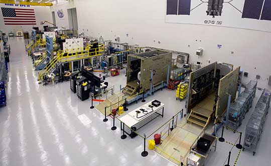
GPS III production line. (Photo: Lockheed Martin)
How about the production status of SVs 03 through 10 on the factory line?
SV03 has gone through complete environmental tests and is ready for delivery to the Air Force later this spring. SV04 is in final environmental test and will deliver later this year. SV05 is in thermal vacuum (TVAC) testing now, and doing an outstanding job. TVAC is the hardest test we go through, and it’s as if it’s flying in the environment of space. It’s the stress test. SV06 is put together, and now in its initial functional testing.
There aren’t many production lines of this size of large satellites. It’s very impressive. As you look down the line, our high bay is modeled after the best of production lines. Hardware and avionics and power systems are coming in as piece parts, getting built in. As you go down the bay, the vehicles are getting more and more complete. Now on the front end of the line we’ve got SV07 and SV08 starting. SV09 will begin later this summer, and not long after we hope to open up space for the 10th vehicle.
Last words: Progress so far on GPS IIIF?
We’re now in the full design campaign for the follow-on satellites that will lead to critical design review, the capstone of the process. The CDR will wrap up in February 2020.
Protective radome housing for the Galileo ground station on desolate Jan Mayen Island in the Norwegian Arctic. The site is housing a Galileo Sensor Station plus satellite link to pass data back to the Galileo ground system. (Photo: ESA/Fermin Alvarez Lopez)
CGI has signed an agreement with Thales Alenia Space France to enhance and maintain security software for the Galileo satellite navigation system.
Valued at approximately 14 million euros, the contract will last until the end of 2020. CGI experts are working on this strategic project from Rotterdam and Toulouse.
CGI will improve the functionality, robustness and reliability of Galileo’s ground infrastructure, as well as enhance and maintain software for its Public Regulated Service Key Management Facility (PKMF).
The Public Regulated Service (PRS) is one of the key features that distinguishes Galileo from other satellite navigation systems. It ensures that only government-authorized entities have access to Galileo’s secure PRS signal that meets strict security standards in areas such as defense, law enforcement and customs.
“We look forward to working with CGI to ensure the highest level of security for Galileo, along with an efficient, high performance infrastructure,” said Guillermo Salgado, Galileo ground mission and EGNOS programs director, Thales Alenia Space France. “CGI’s significant space and security experience, combined with its local presence and global resources, gives us access to the experts we need to launch and operate one of the world’s most advanced satellite navigation systems.”
“CGI has strong legacy in space, and we continue to support space clients across the globe, actively managing their business and national interests while positioning CGI as a trusted space leader,” said Dirk de Groot, who leads CGI’s business unit in the Netherlands.
CGI has more than 40 years of experience in the space domain and delivers complex, mission-critical space software systems across Europe, Asia and North America, supporting programs from satellite navigation, communications and operations, to space-enabled applications.
U.S. positioning, navigation and timing (PNT) capabilities are vitally important to millions of civilians, as well as U.S. and allied militaries.
The third Navigation Technology Satellite will go beyond GPS III — whose capabilities, mark you, are not yet online — to investigate new experimental antennas, flexible and secure signals, increased automation and use of commercial ground assets.
By Joe Rolli, Harris Corporation
Joe Rolli, Director of Business Development, Space and Intelligence Segment. (Photo: Harris Corporation)
Over the past decade, military leadership and national strategists have shared their concerns about U.S. dependence on GPS for everything from financial transactions to commercial transportation scheduling to precision weapon system guidance.
The new generation of Air Force GPS satellites, which began launching in late 2018, marks a significant step toward improving GPS services with three times greater accuracy and up to eight times improved anti-jamming capabilities over the previous GPS satellite block.
Now the Air Force Research Laboratory and the Space and Missile Systems Center are focusing the Department of Defense’s first experimental Navigation Technology Satellite (NTS) in more than 40 years: on initiatives that will demonstrate new tactics, techniques, and procedures to improve PNT resiliency and counter threats to GPS.
As a unique satellite that flies outside of the GPS constellation, NTS-3 will host experiments with impact across the PNT user spectrum — military, civil, academic and commercial. It will explore innovations in atomic clocks, antennas, reprogrammable digital waveform detectors, signals and other technologies.
Harris, the satellite prime contractor for NTS-3, is approaching these mission innovations from the standpoints of responsiveness and resiliency as well as technology advancement. For example, the design will support the simultaneous broadcast of dual-frequency, regional high power, and Earth coverage signals. An agile waveform platform will demonstrate the ability to rapidly develop and deploy new signal waveforms with total flexibility throughout the satellite life cycle. These innovations will allow operation in multiple contested environments, a key to achieving resiliency that can combat electronic jamming, spoofing and more.
Another strategy is the design of a modular NTS-3 payload that can be reprogrammed in space. Based on open, industry standards and interfaces, the payload will be scalable and can be hosted on diverse platforms and in varied orbits with minimal changes.
When NTS-3 launches for its planned one-year experimental campaign — anticipated to begin in 2022 — it will be the latest in a series of experimental spacecraft that have blazed the trail for the extraordinary technological advances that led to the GPS system we enjoy today
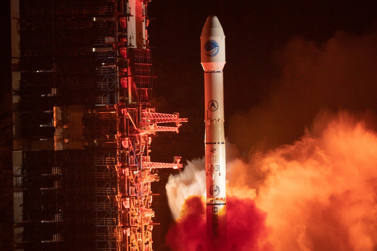
China launched another BeiDou satellite into space from the Xichang Satellite Launch Center in Sichuan Province at 10:41 p.m. April 20, according to Xinhua.
The inclined geosynchronous Earth orbit (IGEO) satellite was launched on a Long March-3B carrier rocket. It is the 44th satellite of the BDS satellite family and the first BDS-3 satellite in inclined geosynchronous Earth orbit.
After in-orbit tests, the satellite will work with 18 other BDS-3 satellites in intermediate circular orbit and another IGEO satellite.
Yang Changfeng, chief designer of the BeiDou system, told Xinhua that the hybrid constellation design will increase the number of visible satellites in the Asia-Pacific region.
According to Yang, the positioning accuracy of the system has reached 10 meters globally and five meters in the Asia-Pacific Region after the system started to provide global service at the end of last year.
The BDS has been widely used around the world, such as in building construction in Kuwait, precision agriculture in Myanmar, land survey and mapping in Uganda and warehousing and logistics in Thailand.
About 8-10 BDS satellites are scheduled to be launched this year, wrapping up launch missions of all BDS-3 satellites in medium Earth orbit. The BDS-3 system is to be completed in 2020.
China is also planning to finish building a high-precision national comprehensive positioning, navigation and timing (PNT) system based on BeiDou by 2035.
Atomic clocks support world’s first black hole photo
Orolia, through its joint venture company T4Science Inc. in Switzerland, supported the ground-breaking scientific initiative to capture the world’s first photo of a black hole, conducted by the Event Horizon Telescope (EHT) project.
As a leader in maser atomic clock technology, Orolia provided the critical timing solution to synchronize telescopes around the world and create a virtual telescope the size of Earth to observe this deep space, supermassive object.
Some of the world’s most advanced telescopes, located at challenging high-altitude sites, were synchronized with T4Science Masers to capture the sharpest image possible. Locations included volcanoes in Hawaii, Arizona mountains, the Spanish Sierra Nevada, the Chilean Atacama Desert and Antarctica.
T4Science masers deliver ultra-precise time synchronization in the most challenging environments on Earth and in Space.
The EHT project uses very long baseline interferometry (VLBI). This technology requires synchronization, phase stability and phase coherence between different telescopes within a few femto-seconds, and leverages the Earth’s rotation to form one Earth-size telescope.
VLBI enables the EHT to achieve an angular resolution of 20 micro-arcseconds — enough to read a newspaper in New York from a sidewalk café in Paris.
Orolia delivers this critical VLBI technology through its T4Science iMaser-3000 hydrogen masers. The iMaser-3000 is a VLBI atomic clock, supporting other mission-critical timing programs such as military and commercial satellite applications.
“Orolia has been a proud supporter of space research and missions for more than forty years,” said Orolia CEO Jean-Yves Courtois. “As the world leader in resilient positioning, navigation and timing solutions, we develop precise, ultra-reliable technology for environments where failure is not an option.”
Orolia’s proven timing solutions support many space agencies and research institutes worldwide, including ESA, NASA, Jet Propulsion Laboratory, SpaceX, the Centre National d’Étude Spatiales (CNES France), the National Physics Laboratory (UK), Deutsches Zentrum für Luft-und Raumfahrt (DLR Germany) and the Japan Aerospace Exploration Agency (JAXA), among others.
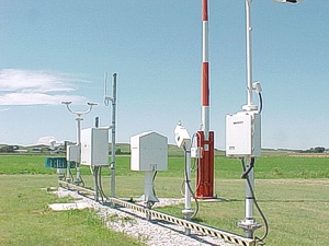
The GPS Week Number Rollover, which took place April 6, has caused several automated NOAA stations to go offline.
Some of the outages could last until November.
Photo: NOAA
According to the EOS website, 19 National Oceanic and Atmospheric Administration (NOAA) coastal and marine automated stations were not updated to mitigate the issue, and those stations are out of commission until workers can service them on location.
The New York Times is reporting that at 7:59 p.m. EDT on Saturday, the New York City Wireless Network went dark, interrupting functions such as the collection and transmission of information from some Police Department license plate readers, Department of Transportation traffic-light programming, and communications at remote work sites for the sanitation and parks departments.
The city is now working overtime to bring affected systems back online, reports StateScoop.
Previously, GPS World reported on rollover issue for the Australian Bureau of Meteorology’s (BOM) weather balloons, as well as Boeing aircraft. Read more about the Boeing issue here.
On May 7, the GPS Directorate will hold a virtual Public Interface Control Working Group Meeting. The meeting will take place 8:30–10:30 a.m. PST.
During the meeting, the directorate will review changes to several GPS public documents to reflect how users will calculate the correct UT1 time following a leap-second transition.
The 2019 virtual Public Interface Control Working Group is open to the public. The meeting is available through dial-in only.
The meeting will update the public on GPS public document revisions and collect issues and comments for analysis and possible integration into future GPS public document revisions.
For more on the revisions,as well as dial-in and contact information, go to GPS.gov. Also see the Federal Register notice.
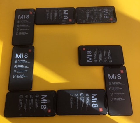
Xiaomi Mi 8 dual-frequency smartphones procured for teams participating in ESA’s second Galileo App Competition, taking place at ESTEC in the Netherlands on April 18. (Photo: ESA)
The final presentations of ESA’s second Galileo smartphone app competition will take place April 18. The public is invited to watch the awards ceremony via livestream.
The competition’s goal is to develop an app capable of performing fixes using raw Galileo satnav measurements. Members of the public can also vote for their favorite app.
Five teams are competing this year. The competition is run by the European Space Agency (ESA)
in collaboration with the European Global Navigation Satellite Systems Agency (GSA) plus the European Commission with the support of Google. It was open to all students from European universities and trainees in posts at European research and development organisations.
Harris Corporation has received a $243 million contract from Lockheed Martin to provide fully digital navigation signals for the first two GPS III Follow-On (GPS IIIF) satellites — to deliver stronger signals, with greater operational flexibility.
Harris’ GPS IIIF fully-digital Mission Data Unit (MDU), the heart of the satellite’s navigation payload which generates the GPS signals, will provide more powerful signals, assure flawless clock operations for GPS users, and add flexibility to adapt to advances in GPS technology, as well as future changes in mission needs.
It will provide improved capabilities over Harris’ 70-percent-digital MDU used for GPS III Space Vehicles 01-10 (GPS III SV01-10).
The new MDU also offers the Air Force a smooth transition to its GPS OCX ground control segment. Harris will seamlessly port its digital signal design, minimizing both integration risks and associated costs.
In September 2018, the U.S. Air Force selected Lockheed Martin, with Harris as its navigation signal partner, to build up to 22 GPS IIIF satellites, with a total estimated contract value up to $7.2 billion.
The Air Force expects the first GPS IIIF satellite, SV11, to be available for launch in 2026.
Launched aboard GPS III SV01 in December 2018, Harris’ first GPS III navigation payload began broadcasting navigation signals on January 8. While testing of the first-of-its-kind satellite continues, the payload has performed beyond expectations.
Harris has provided navigation technology for every U.S. GPS satellite ever launched, enabling the reliable GPS signal that millions of people — including U.S. soldiers — and billions of dollars in commerce depend on every day.