Many have heard about efforts by Amazon to use UAVs for home delivery of orders within hours. Unfortunately, Amazon’s UAV trials have yet to be transitioned to “production” across the United States. Its website states that UAV deliveries are only available in College Station, Texas, and Lockeford, California.
Walmart is also in a trial phase of getting its rapid UAV delivery system working; however, its same-day UAV delivery is only servicing customers in the Tampa, Orlando, Phoenix, and Dallas areas. Nevertheless, there are many other automated deliveries underway around the world for meals and product deliveries, especially in Asia.
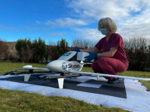
One segment where UAV deliveries appear to have been successful for medical samples and medications, which are now being shipped regularly on time-sensitive routes by UAVs (and, of course, several trial deliveries of these items are still underway).
The EMED transport/courier service used extensively by the UK National Health Service took part in one of the most recent medical shipment trials — which recently wrapped up in UK — with more than 400 pathology samples being rapidly shipped by fixed-wing UAVs between two hospital sites.
Loading a UAV in a UK medical trial. (Image: ESA)
The UAV used in the EMED trial was a tried and tested Swoop Aero Kookaburra III fixed-wing aircraft with a 3kg payload that flies at 330 ft in segregated airspace.
In the United States, OhioHealth aims to use a proven medical delivery system supplied by Zipline. Its plans for delivery UAVs include rapid shipments between Ohio medical facilities and prescription delivery to patients. By 2025, OhioHealth predicts that more than two million people in the Columbus area could be served by the Zipline delivery system.
OhioHealth plans to use Zipline’s Platform 2 delivery UAV — a fixed-wing carrier UAV with vertical take-off and landing (VTOL) capabilities able to autonomously hover and accurately lower a package-carrying “droid” into a tight delivery spot. The previous Zipline Platform 1 system drops packages by parachute, which requires a substantial area to receive deliveries. The “droid” has three directional fans that allow it to maneuver at the end of the tether to within six feet of the planned delivery point.
Over the last six years, Zipline has built up a whole fleet of Platform 1 aircraft and the complete infrastructure for its medical delivery operation in Rwanda.
In Rwanda, there was a need for different delivery methods to get medical supplies to hospitals, as communities are spread over large distances. Before bringing such a service to the United States, Zipline aimed to get a delivery service running, get experience, and de-bug and prove the system’s capabilities. Six years and half a million deliveries later, Zipline is now ready. For civil certification, the Federal Aviation Administration previously liked to see lots of evidence of established operational activity. Therefore, Zipline was fortunate to have six years of proven delivery activity in Rwanda when they looked to start up in the United States.
Platform 2 ‘droid’ containing a package is lowered on a tether from a hovering carrier drone. (Image: Zipline)
Zipline has also done everything needed to ensure the delivery process in Rwanda is as efficient as possible — from the order processing system, through packaging and loading into the UAV, a catapult launch system that accelerates the aircraft to climb-out speed, battery charging and exchange for each flight, autonomous navigation to the delivery point, parachute delivery at destination, autonomous return to base, and an automated capture system on arrival. As a result, it’s not unusual if a delivery can be dispatched within 90 seconds from receipt of an order.
The distances are large in Rwanda between where people are sick and where they can get help, and the necessary supplies may well be located elsewhere — at times, as much as 150 miles away. However, since Zipline deliveries became common, in-hospital maternal mortality rates have been reduced by 88% — quite an achievement. Each delivery that is dispatched really has the potential to save a life.
Now, Zipline has the potential to improve turn-round times for the health system in the United States. The company is ready to prove that the Platform 2 system makes very little noise because of specially designed propellers, that precise deliveries are possible, and it is even ready to take on regular parcel deliveries without being limited to only medical shipments.
Hopefully, some of the big retail organizations will be willing to watch, listen, trial and eventually bring the proven Zipline delivery system into their operations. There is much work to do to bring about regular UAV deliveries, but with a proven track record in Rwanda, the odds favor a successful outcome in the United States.
Sitting comfortably in a thin aluminum tube at 35,000 ft, I can continue to communicate via e-mail — and, soon, via video — and write this editorial, while on my way from Portland, Oregon, where I live, to Cleveland, Ohio, where North Coast Media, this magazine’s publisher, is based.
I can safely assume that the pilot knows our position, heading, and speed with great accuracy and receives excellent weather reports. The computer on my wrist (made by the largest manufacturer of GNSS-based consumer devices) and the much more powerful one in the holster on my belt, can do way more than Dick Tracy’s creator, Chester Gould, could have ever imagined a gadget produced by Diet Smith Industries to do.
One thing that communications, navigation, and weather forecasts currently share is reliance on satellites — be they in geostationary Earth orbit (GEO), at 22,000 mi, which are used mostly for weather data, broadcast television and, increasingly, data communication; medium Earth orbit (MEO), at 3,000 mi to 12,000 mi, including GNSS satellites and those that provide Internet connectivity; or low-Earth orbit (LEO), 300 mi to 745 mi, with thousands of satellites in operation today, primarily addressing science, imaging, and low-bandwidth telecommunications needs — and, coming, a new generation of satellite-based positioning, navigation, and timing (PNT) services.
Another thing these feats of engineering share is their foundation on the purest science and mathematics. To take one example, had the designers of GPS failed to adjust the system by 38 ms per day to account for both Albert Einstein’s 1905 Special Theory of Relativity and his 1915 General Theory of Relativity, positional errors would cumulate at a rate of about 6.2 mi each day, making GPS utterly worthless for navigation in a very short time. That’s because Einstein’s 1905 theory leads to the prediction that the atomic clocks on GPS satellites should fall behind clocks on the ground by about 7 ms per day because of their slower ticking rate due to the time dilation effect of their relative motion — while his 1915 theory leads to the prediction that they would be ticking faster than identical clocks on the ground by 45 ms per day due to the curvature of spacetime.
As with most complex technologies, the scientific principles, technical challenges, and policy debates behind GNSS are unknown and irrelevant to more than 99% of the public, few of whom even know that GPS is not the only global navigation satellite system in existence today. The technology is transparent to them. Most of them say “GPS” to refer to GNSS receivers, digital maps, driving directions and traffic data without understanding the separate, though overlapping, technologies, business models and data sources involved. This routinely results in misunderstandings and misattributed complaints and praises — such as when drivers blame “their GPS” (meaning their GPS receiver) for leading them up a dead end that was due to a mapping company being one step behind new construction or praise it for traffic alerts for which they should thank crowd-sourced data and algorithms.
In May the President’s PNT Advisory Board heard a presentation about a National Guard project called NITRO. RNT Foundation President, Dana Goward, recently spoke with the project’s leader, Maj. Gen. Richard R. Neely, Adjutant General, Illinois National Guard, to find out more.
Mr. Goward: Thanks for speaking with us, General. Could you start by telling us what NITRO is and why it’s important?
Maj. Gen. Neely: Of course. NITRO is a project to ensure that the National Guard and our state’s first-responder partners can maintain communications and other critical functions even if we lose GPS timing signals.
NITRO is an acronym for Nationwide Integration of Timing Resiliency for Operations. ]You know how we in the military love our acronyms.
Telecoms and most of the rest of America’s critical infrastructure are dependent on timing from GPS. However, GPS signals are weak, highly vulnerable and under threat.
In addition to bad actors who can and do jam and spoof signals, accidental interference happens all the time. Operations at the Dallas and Denver airports were each interrupted by accident for more than a day last year, for example. A couple of years ago, a passenger airliner almost hit a mountain because of interference with GPS.
Q: It sounds like this is a safety of life issue.
A: It is. Right now, if we lost GPS signals and had to respond to a domestic attack, natural disaster, or other contingency, I am confident there would be additional unnecessary casualties. We are building NITRO so that we can save those lives and keep America safe.
Q: So how does NITRO work?
A: In addition to GPS, it gets multiple sources of space-based and terrestrial time from government and commercial providers. NITRO can use any trusted source. It is not provider- or vendor-specific.
Inputs are combined and compared, matched to the nation’s atomic clocks keeping Coordinated Universal Time, and users are sent the best accurate time multiple ways including over fiber, terrestrial broadcast, and resilient wireless networks.
Another great way in which I think it will be useful: NITRO gives us a common operating picture that can help detect and terminate GPS disruptions and anomalies around the country.
Q: Is the National Guard the only user?
A: Absolutely not! This is a state/federal partnership. The states’ Adjutant Generals are working with their Homeland Security Advisors to make it available to state, local, and tribal first responders. In some instances, also to critical infrastructure.
Even though we are in the early stages of implementation, NITRO is being used by seven states and 256 organizations and it is protecting more than 33 million people, including citizens here in Illinois.
Q: Is NITRO a tasking from the President or Congress? Who told you to do this?
A: NITRO helps execute long standing presidential policy and orders, as well as the recently released National Cybersecurity Implementation Plan. It also meets congressional mandates for backups and alternatives to GPS timing.
However, we created NITRO because we identified a serious threat to the National Guard’s mission execution. It closes 11 operational gaps for us, all without changes to end-user equipment.
Q: With what groups are the NITRO team working?
A: All the states are involved through their adjutant generals, homeland security advisors, and emergency managers. The NITRO board I chair is made up of the adjutant generals from six states.
We are also coordinating across the federal government, especially with the Departments of Homeland Security, Transportation, Commerce, and Energy.
As part of this we are partnering with the Department of Transportation to establish a NITRO engineering and operational site at Joint Base Cape Cod. This will allow engineers from different organizations to see more easily what we are doing and contribute their expertise.
Q: NITRO is going to provide timing signals in places and at times when GPS is not available. Won’t the National Guard also need navigation information?
A: Positioning and navigation are very important, but not quite as critical as timing. So, we are addressing that problem first. And since wireless location and navigation are often based on timing signals, NITRO will provide a good foundation for services and systems that can augment GPS-based navigation.
Q: So, how is the project going?
A: From a technical and operational standpoint, it’s going great. We have very high satisfaction ratings from NITRO users, and states are eager to be connected as soon as possible.
The technologies used are all mature, reasonably low cost, and most components are commercially available. So, engineering-wise it is low risk.
And our team is doing a great job helping folks move from full dependency on GPS to resilient positioning, navigation and timing (PNT) operations.
Q: Do you have any concerns going forward to full deployment?
A: The only thing I worry about is continued funding. Over the next five years we need something less than the cost of one GPS satellite. You would think that would be easy to find for an important effort like this, but it is a state/federal partnership, not a Department of Defense project. So, it falls into a kind of bureaucratic and budgetary no man’s land.
Q: What’s the solution for funding?
A: That’s not our call. The folks at the White House are exploring several alternatives, and I know several members of Congress are also concerned. We see a possibility of this fitting nicely with the recent infrastructure funding bill.
Q: It sounds like NITRO is something America really needs. Let’s hope they find a solution to the funding challenge, and quickly, to keep you on track. Thank you very much for your time!
Anyone keeping up with my columns may know that I have been highlighting the geodesy crisis and programs that advance the science of geodesy (July 2020, November 2022, December 2022, and March 2023). On June 13-15, I had the privilege of participating in a working group event convened by the Geomatics Emerging Scientist Consortium for Education, Research and Capabilities Enhancement (GEO-ESCON). The GEO-ESCON, established in the summer of 2022, is a multi-university consortium serving the need of the Office of Geomatics of the National Geospatial-Intelligence Agency (NGA) for personnel with advanced geomatics expertise, a sustainable pipeline of critical geomatics skillsets, and capabilities enhancement in geomatics and other applied sciences. The 15-member consortium is led by The Ohio State University (OSU), which serves as GEO-ESCON’s managing higher education partner.
GEO-ESCON is part of OSU’s Battelle Center for Science, Engineering and Public Policy in the John Glenn College of Public Affairs. As stated in an OSU press release, OSU was selected for its role with GEO-ESCON because of its longstanding commitment to geodetic education — its collegiate geodetic program is the oldest in the United States and offers undergraduate and graduate degrees in both geodetic engineering and geodetic science.
OSU is home to more than 80 researchers across six colleges who focus on core research and development aspects of geospatial science and technology, including geodesy, remote sensing, photogrammetry, GIS, positioning, navigation, and timing (PNT), computer vision, mobility, smart cities, data analytics, autonomous systems (UAS, UUS and UGV), medical imaging, and precision agriculture.
The GEO-ESCON consortium is designed to create a geographically distributed, multi-disciplinary network of universities to educate the federal geomatics workforce at advanced levels and provide opportunities for applied research and technology development. Higher education institutions are invited to participate in GEO-ESCON based on their capabilities in geomatics. As of July 18, the consortium has 15 members and two additional universities are in the process of becoming members. Click here for all GEO-ESCON member institutions.
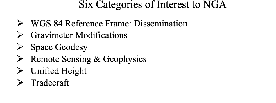
GEO-ESCON convened the June Geomatics Challenge Working Group to discuss pressing geomatics challenges and discuss potential solutions. The event facilitated dialogue between representatives from NGA’s Office of Geomatics and academic attendees on geomatics challenges of national priority that could result in actionable proposals to address the challenges. The working group enables representatives of GEO-ESCON member institutions to gain a deeper understanding of NGA’s geomatics priorities, build relationships with NGA leaders, collaborate with colleagues at other institutions, and provide recommendations to GEO-ESCON and the NGA. There were 47 academic participants representing 14 universities.
NGA aims to encourage institutions with varied expertise to propose solutions that achieve greater outcomes through collaborative work. The agency provided six broad categories of geomatics challenges for discussion. See the image below for the categories of interest.
Proposals submitted in response to the June Geomatics Challenges Request for Proposals (RFP) will be eligible for funding consideration and selected activities are expected to be awarded before the fall semester.
The word “tradecraft” in the categories of interest was intriguing. In general, tradecraft refers to the skills, techniques, and practices used by professionals in various fields to carry out their work effectively and discreetly. During World War II, however, the term became associated with spy work and now is mostly used to refer to the techniques and procedures of espionage. NGA is concerned with the dramatic drop in the number of individuals pursuing careers in geodesy — that is, the geodesy crisis in the United States.
Event attendees were asked to prioritize the topic(s) that most interested them, so that they could join a small group on the topic to identify issues, and discuss approaches, solutions, and potential actions for the challenge. Several universities had multiple representatives, so they selected different topics aligned with their individual interest.
The meeting had professional workshop facilitators, technical advisors, NGA subject matter experts (SME), and student recorders. Facilitators encouraged the full participation of all attendees to elicit a range of viewpoints and generate previously unconsidered solutions that could bridge differences in approach — resulting in solutions that were supported by many.
The small groups aligned with a specific challenge utilized the expertise of technical advisors — experts in geomatics or related fields with considerable industry, government, and/or research experience — who supported the development and maturation of proposed Geomatics Challenge solutions. The role of technical advisors was to work with the other leaders in their small group to encourage the full participation of all attendees and mentor the groups toward the generation of novel solutions. I was a technical advisor for the “unified height” topic.
NGA’s SME participated in the working group activities and provided additional context for the individual topics, and other unclassified details related to the Geomatics Challenges.
To capture the discussions at the group meetings, student recorders took detailed notes during the small group discussions. The recorders were graduate students — primarily in geodesy or other STEM fields — and they did an excellent job of capturing the discussion, action items, and potential proposals.
As previously stated, individuals self-selected the topic that interested them but over the course of the three-day meeting individuals were asked to participate in other Geomatics Challenge small groups to provide constructive critiques to produce the best research projects. This was an excellent concept that, in my opinion, helped to improve draft proposals and identify new collaborative projects.
As an example, the need for a unified height system that defines, assesses and correlates all height measurement processes became very evident when individuals participating in the “remote sensing and geophysics” topic engaged with the “unified height” topic members. This joint-topic group meeting helped form new partnerships and formulate new proposals.
The GEO-ESCON and the participating institutions have an ambitious schedule of submitting and awarding the grant proposals before the end of the government’s fiscal year. That said, the participants appeared to be up to the challenge and prepared to make it happen. For obvious reasons, I cannot describe any of the projects discussed, but I will highlight them when they become available for public distribution.
For now, I would like to state that GEO-ESCON is a great program, and it supports the advancement of the science of geodesy and geomatics. I believe that integrated and collaborative organizations are necessary for the successful development of geospatial products and services, and GEO-ESCON is the epitome of this concept. If you believe your institution would benefit from joining this consortium, I encourage you to visit their website to learn more or reach out directly to GEO-ESCON’s team ([email protected]). Click here to subscribe and stay up to date on GEO-ESCON news.
In conclusion, as in my previous column, I would like to remind everyone that geodesy is the foundation for all geospatial products and services.
Image: Kara Capaldo/iStock/Getty Images Plus/Getty Images
Whether preparing for natural disasters or responding to everyday emergencies, first responders depend on the accuracy and dependability of GPS data to keep our communities safe. However, the increasing number and intensity of natural disasters, such as wildfires and hurricanes, and ongoing first responder staffing shortages have pushed the industry to look for ways to combine the tried-and-true benefits of GPS with new artificial intelligence (AI) technology to alert sooner, respond faster, and restore better than ever. The integration of AI’s adaptive learning capabilities with the ability of GPS to operate in areas of low or no connectivity make for cutting-edge emergency service solutions.
New technologies incorporating both AI and GPS have already proven to save time and protect lives by quickly identifying and assessing potential fires. For example, in 2022, Sonoma County, California, used FireScout — an AI-powered fire detection solution — to monitor live footage for signs of fire and alert authorities. In one instance, the county found that FireScout’s AI solution detected and located — using GPS data — a fire 10 minutes before the 911 service was alerted about it, giving responders a head start on containing the fire. FireScout looks to integrate GPS functions more fully into their AI-enabled cameras with exact coordinate information. Investments in innovations that facilitate rapid response to natural disasters will lead to greater safety for first responders and their communities across the country.
One way the industry is investing in GPS-powered AI innovation is through problem-solving competitions such as XPrize Wildfire, which encourages the development of cutting-edge solutions to wildfires. Teams will compete in one of two tracks: the Autonomous Wildfire Response track, which requires teams to combine AI and GPS data to differentiate between high-risk actual fires and decoy fires and then quickly suppress the real fires, and the Space-Based Wildfire Detection and Intelligence track, which requires teams to use satellites to accurately pinpoint fires across vast areas then relay that information to stations on the ground. GPS industry leader Lockheed Martin is providing a $1 million Accurate Detection Intelligence Bonus Prize to the winner of the XPrize Wildfire competition. Competitions such as XPrize Wildfire will result in products that can identify fires faster, reducing response times and minimizing damages to communities.
Additionally, new GPS-powered AI solutions are bringing emergency resources to more people in the wake of hurricanes. In the aftermath of hurricanes, emergency personnel are tasked with identifying and allocating resources to restoration efforts. GPS-powered AI technologies such as the University of Connecticut’s hurricane monitoring system, compare pre-storm and post-storm satellite imagery to spot potential environmental and safety issues, such as flood water or damaged neighborhoods. The system then highlights those areas on a map and shares the coordinates of high-damage areas with emergency personnel. Services such as these support communities and allow restoration efforts to begin sooner with less risk to surveyors and responders.
Beyond natural disasters, GPS also is being used with AI technology to shorten response times for emergency vehicles. Many towns, including St. Louis, Michigan, and Leon Valley, Texas, have implemented AI traffic light systems that use location data to detect the location of ambulances and fire trucks to give the vehicles a path of green lights, clearing out any traffic that might have slowed response times. Similarly, researchers at the University of Southern California are using UAVs — guided and tracked using GPS data — to carry automated external defibrillators (AEDs) to remote locations. These UAVs use coordinates provided by GPS receivers to operate in areas of limited connectivity and AI to determine the most efficient landing locations for different terrains. Ongoing research and further investment into the critical intersections of GPS and AI technology will help promote a safer future by supporting first responders and protecting communities in emergencies.
The GPS Innovation Alliance (GPSIA) welcomes innovations in GPS and AI technologies that continue to revolutionize the way we respond to natural disasters and life-threatening emergencies. GPSIA is proud to support the expansion of these disaster-mitigating solutions by uplifting innovative research and design efforts, promoting new ideas, and ensuring adequate regulation is in place to protect users across the globe.
OEM products are vital to many industries. Companies such as Septentrio and SBG Systems design and produce a variety of OEM devices for many different applications. (Image: sankai/E+/Getty Images)
OEM devices are an integral part of many applications requiring precise positioning technology. As the OEM market grows and performance requirements become more demanding, it is critical for OEM devices to be reliable, accurate, and easy to integrate. From precision agriculture, to surveying and mapping, to UAV missions, there are OEM devices on the market suitable for demanding applications.
Survey and Map Like a Pro
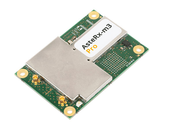
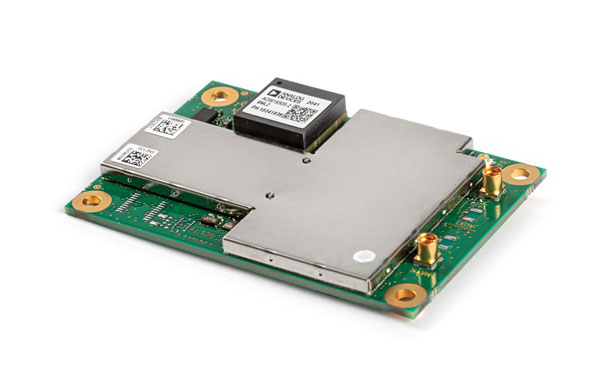
Surveying and mapping is one area in which OEM boards are embedded deep in many products. Septentrio designs and manufactures multi-frequency, multi-constellation, GPS/GNSS positioning technology and offers a variety of OEM products for demanding applications.
Image: Septentrio
The AsteRx-m3 Pro is an ultra-low power GNSS rover receiver. It is compact and high-performance, making it suitable for integration into high-precision industrial applications. It incorporates multi-frequency, multi-constellation GNSS technology as well as anti-jamming algorithms for availability and reliability. The AsteRx-m3 Pro features AIM+ advanced anti-jamming and anti-spoofing technology as a part of Septentrio’s GNSS+ Technology Suite.
This receiver is designed for rover (mobile) applications, making it an easy-to-integrate solution for any kinematic application where reliable high-accuracy positioning is needed. It is available in single or dual antenna mode, for high quality heading and pitch, or heading and roll information.
GNSS heading is available directly from initialization and removes reliance on vehicle dynamics or magnetic sensors. This is an optional feature.
“Septentrio OEM receivers come in a variety of form factors, from compact modules to credit-card boards,” Danilo Sabbatini, OEM product manager at Septentrio, stated. “Our multi-frequency OEM receiver portfolio includes products that fit various user needs from purely rover GNSS high accuracy positioning to heading receivers, as well as GNSS/INS boards for inertial navigation or mapping.”
Image: Septentrio
Aside from surveying and mapping, the AsteRx-m3 Pro is suitable for assured position, navigation and timing (PNT), autonomous vehicles, precision agriculture, logistics and port operations, mining and construction, rail, robotics, space and UAV applications.
Plowing the Way
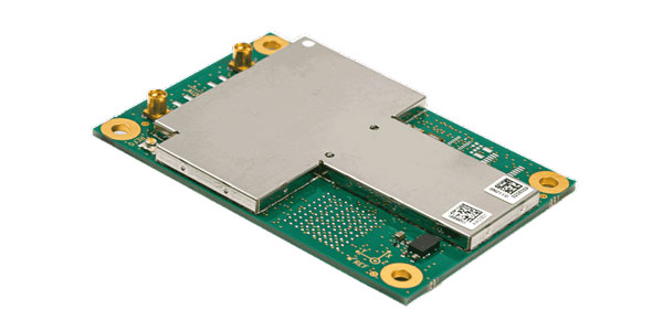
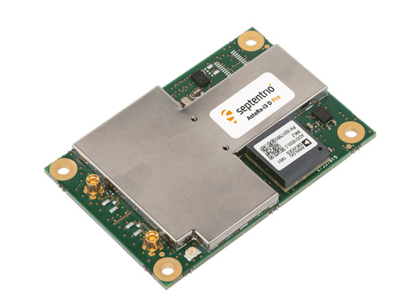
The increase in demand for food due to population growth challenges farmers to increase production. To help them do this, Septentrio is working with manufacturers of agricultural machinery to enable them to achieve centimeter-level positioning accuracy.
Image: Septentrio
The AsteRx-i3 D Pro is a ready-to-use GNSS/INS single-board receiver that delivers reliable centimeter-level positioning combined with 3D orientation (heading, pitch and roll) in demanding environments. Its inertial sensor provides orientation and positional dead-reckoning, making it suitable for systems that require continuous positioning even during short GNSS outages. It provides reliable and accurate positioning by enhancing GNSS with an inertial measurement unit (IMU).
Image: Septentrio
The AsteRx-i3 D Pro is quad-constellation and multi-frequency. It provides all-in-view real-time kinematic positioning and features AIM+ unique interference monitoring and mitigation system and other advanced GNSS+ algorithms.
Like the AsteRx-m3 Pro, the AsteRx-i3 D Pro is also suitable for assured PNT, autonomous vehicles, logistics and port operations, mining and construction, rail, robotics, space, survey and mapping, and UAV applications.
For more information about Septentrio’s OEM boards, click here.
Flying High
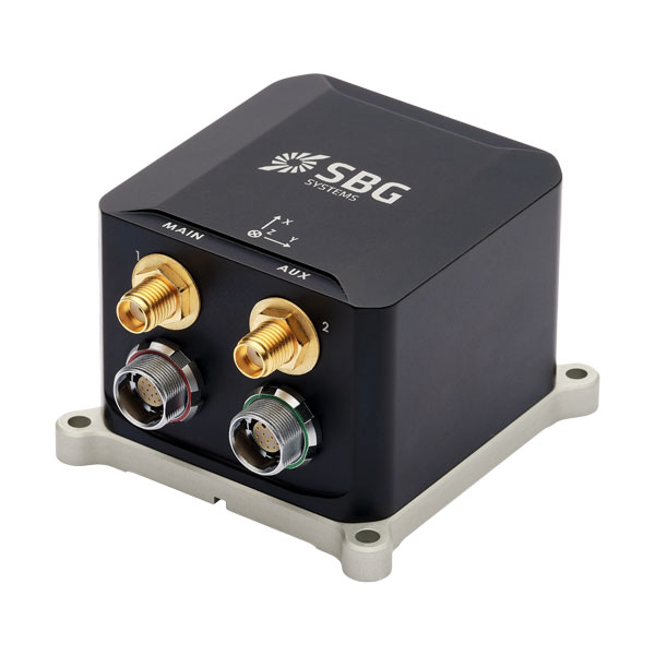
SBG Systems has released Ekinox Micro, a compact and rugged high-performance inertial navigation solution designed to deliver accuracy in challenging environments. Ekinox Micro combines a high-performance MEMS tactical inertial sensor with a quad-constellation, dual-antenna GNSS receiver, making it suitable for mission-critical applications.
Image: SBG Systems
GPS World caught up with Yoann Plénet, head of products at SBG Systems, at AUSVI XPONENTIAL in May. He elaborated on Ekinox Micro’s key markets and features.
“This is Quanta Micro in a box with the same performance and the same benefits that you get [with the Quanta Micro]: inertia, enhanced GNSS, and complement[ing] the GNSS,” Yoann said. “At the same time, we are targeting very rough environments, especially larger drones which are most likely military ones. So, [Ekinox Micro] is a very rugged product.”
Ekinox Micro includes pre-configured motion profiles for land, air and marine applications, enabling the sensor and algorithms to be tuned for maximum performance in any condition. The device is designed for ease of use and integration, with simple connectors, a web configuration interface, a datalogger, Ethernet connectivity, a PTP server, a REST API for configuration, and multiple input and output formats.
Image: SBG Systems
Ekinox Micro is compatible with real-time kinematic (RTK) and based on a tactical 0.8°/h class inertial measurement unit calibrated across the entire operating temperature range. It features accuracy roll/pitch of 0.015°, accuracy heading of 0.035°, and accuracy position of 1.2 m without any corrections or 1 cm in RTK.
Yoann also said that with the rise of jamming and spoofing, Ekinox Micro is designed with enhanced technology to mitigate those threats.
“Jamming and spoofing is ongoing and is an issue for more and more of our clients. So, we have worked a lot — and that is something that is beneficial to all of our product ranges — on enhancing our algorithms and our technology so we can better detect jamming and spoofing than we could before,” Yoann said.
Ekinox Micro will be commercially available in September. Click here for more information on Ekinox Micro.
Bonus Device
Image: Septentrio
The Septentrio mosaic-X5 is a multi-band, multi-constellation GNSS receiver in a low power surface mount module with a wide array of interfaces. It is designed for mass market applications such as robotics and autonomous systems — capable of tracking all GNSS constellations, supporting current and future signals.
The mosaic-X5 has an update rate of 100 Hz, is easy to integrate, and is optimized for automated assembly.
Antoon De Proft, Septentrio’s CEO, mentioned in the April 2023 issue of GPS World the company’s innovation in Leuven, Belgium.
“Septentrio’s 20 years of experience in GNSS technology as well as our strategic partnership with the European Space Agency and close collaboration with the IMEC semiconductor technology hub has enabled us to produce the mosaic-X5 receiver,” he said. “This compact module is one of the highest performing and resilient GNSS receivers on the market. It is used in a wide array of applications, especially where the position is mission critical. Examples include a wide variety of autonomous devices, including drones that benefit from mosaic’s lightweight and low-power design.”
Francois Freulon, head of product management, added, “Reliability and resilience to GNSS vulnerabilities is a key pillar on which we base our receiver design. RF interference in the form of jamming and spoofing* is increasingly common, which is why we are investing heavily in securing our receivers at the core with the latest hardware and software techniques. In addition to the AIM+ patented technology, the mosaic module already includes OSNMA functionality, which will offer end-to-end authentication on Galileo’s civilian signals, protecting receivers from GNSS spoofing attacks.”
For more information about Septentrio’s mosaic GPS/GNSS modules, click here.
The U.S. government has visibly and physically conveyed its interest in getting air taxis into operation, through a visit of 70 people — attached to the newly formed Advanced Air Mobility (AAM) Coordination group — to Archer Aviation. The group talked with the executives of the company developing the “Midnight’ air-taxi aircraft and watched a flight test.
The AAM group includes members from leading government agencies concerned with making and keeping this segment of aviation successful, including the Federal Aviation Administration (FAA), the Department of Transportation (DOT), the National Aeronautics and Space Administration (NASA), the Department of Defense (DOD) and other agencies.
AAM group visits Archer Aviation. (Image: Archer Aviation)
Gathering the views of Archer and other electric vertical takeoff and landing (eVTOL) developer executives should be an essential part of the AAM group’s information collection task. And while it’s great to see that the interagency group has every intention of promoting the AAM concept of air taxis, it would perhaps be better if the group also had access to representatives of manufacturers, developers, and those with UAS experience. It’s clear that we need to start by spreading the word, but also by including people in the group who have dedicated themselves to bringing these capabilities to market — that may make the process more efficient.
Along the way, it may also help to understand that the processes we have used in the past to get airframes like this into passenger carrying operations might not work well with this new industry. It’s understandable that it should take a lengthy period to assess, verify, qualify and certify such vehicles in the name of safety, but if companies run out of cash and fold in the interim — which is highly likely with this “start-up industry” — then shouldn’t we be looking for a better way to get these guys off the ground?
No one wants safety to be sacrificed, but could there be some way to streamline, speed up, or simplify the process without skipping essential steps — a way to get new technology into use before it’s obsolete, or a lack of start-up money dooms its progress? The forecast for the economy in the near future is in the billions of dollars. So, providing funding to improve the current processes does make sense. DOD has started to put serious effort into speeding up its acquisition process and has empowered the Defense Innovation Unit (DIU) to find quicker ways to bring commercial technologies into defense.
The processes used to bring new technologies into use are tried and proven, but they are lengthy. In defense, if our opposition can field things quicker than we do, they have an edge in strategy, tactics and a higher probability of winning in battle. These countries are using the same approaches in the commercial world too, and we need to be wary that they may also have a greater chance of winning the “economic war.”
Nevertheless, Archer in California and others such as Joby, also in California, and Liliam in Germany, plod on through varying stages of FAA and European Union Aviation Safety Agency (EASA) certification paths. An example of the effort that a company has been required to put into fulfilling the requirements of a certification agency is that of Lilium, which first applied for its Design Organization Approval (DOA) in 2017, is still churning through the qualification efforts and does not expect approval until 2025. Of course, the answer is “Don’t get on the certification ‘hamster-wheel’ unless you can stand the journey.” However, we do want these systems and vehicles to make it in order to overcome some of the traffic nightmare that we are living through in our major cities and to contribute to the growth in the economy.
Meanwhile, the great hope (even expectation) of the “flying car” is being kept alive by Doroni in Miami with its two seat H1 eVTOL. Having largely burnt through its $3.6 million StartEngine launch money, Doroni is looking for its second round of funding to build more prototypes and join the certification race. However, other single seat eVTOL flying cars have taken the easier route to certify under the FAA Ultralight category.
Doroni H1 prototype. (Image: Doroni)
The H1 has semi-autonomous capability, which Doroni claims will make its eVTOL easy to fly, and allow general sales to any car driver. With air bags, an aerodynamic fuselage — which generates lift — 10 independent propulsion systems (four double prop ducted fans and two forward thrust props), an airframe that can behave as a parachute and “dissipate energy” in case of a crash, and landing gear, the H1 also has multiple independent batteries — all aimed at safety, which will help make it through certification verification. So, if you happen to have the $250,000 proposed sale price and are willing to wait on the completion of FAA certification, you could own your own “flying car.”
Doroni just announced that they have already made 50 test flights within their manufacturing facility along that test and qualification road.
Meanwhile, Ryse Aerotech in Ohio, recently demonstrated a manned test flight of its single seat Recon eVTOL — billed as an aid to farmers, with a top speed around 58 mph, a range of about 25 miles and with the right FAA clearance it could even reach an altitude of 700 ft — an airborne ATV for inspecting crops and the like.
Recon manned test flight in June 2023. (Image: Ryse Aerotech)
The path to market that Ryse has selected, however, should see more vehicles in earlier use than Doroni’s H1. All you may need is a driver’s license to take off in a Recon because it’s qualified as an Ultralight craft — just buy and fly. Beware, you cannot fly anywhere near an airport or after dark. FAA has restrictions on Ultralight craft.
So, progress on the semi-autonomous “flying-car” front and a plea to consider the economic benefits and to look to how to improve the efficiency of the existing certification process — not a request to cut corners, rather a request to speed up the processes and save this start-up industry before it goes broke.
“Could a new PNT constellation using LEO satellites fully replace the services provided by the four existing GNSS constellations?”
Mitch Narins
“From a pure capabilities standpoint, the answer is “Yes”. LEO constellations can provide the PNT performance metrics that users require. However, should this strategy be followed, it would lack the diverse, complementary solutions needed to ensure the safety, security, and efficiency of critical infrastructure. Many have recognized the need for resilient PNT solutions and identified system-of-systems approaches. Multiple satellite constellations — MEOs and LEOs (despite the number of platforms) — lack this needed resilience. A resilient system-of-systems should include satellites in multiple orbits and complementary ground-based PNT infrastructure, each providing needed performance and overall demonstrating resilience from diverse threats.”
— Mitch Narins Strategic Synergies
John Fischer
“In theory, yes. With a much stronger signal (antijam) that is encrypted (antijam), they counter GNSS’s two main vulnerabilities. However, with a paid service business model, it is difficult to compete with a free service. Moreover, large constellations are needed to overcome GDOP. OneWeb, Starlink, et al. already have launched and will continue to launch large constellations, so they must compete with these high bandwidth communications constellations that can provide accurate PNT as a side service and don’t have a GDOP limitation because of their size. Adoption of a single-purpose PNT system will be difficult.”
— John Fischer Orolia
Bernard Gruber
“Yes, it could. That said, as with any new product or technology, evolution of PNT capabilities will be dependent on competition, value or threats that undermine the current environment. Burgeoning systems such as Xona, Satelles or any number of augmentations utilizing “signal of interest” such as Starlink will rightly contribute to the evolution of enhanced PNT. Current advantages of LEO-based systems such as increased received power, decreased convergence time and numerical diversity are noteworthy, but replacing an investment of $100B+ government backed GNSS systems that adhere to well established policies and published ICDs is another.”
— Bernie Gruber Northrop Grumman
Jules McNeff
“As my colleagues above note, the answer is yes from a technical perspective. However, in practice, not so much. Even with software-defined receivers, issues of signal reception and processing, interface standards, comm/nav service prioritization, security, integration into complex systems, integrity assurance, etc. make use of such nav services in lieu of purpose-built GNSS services impractical.”
Max Weber famously described how bureaucratic inertia often leads formal organizations, such as government agencies, to devise new justifications for themselves after they have outlived their original purpose. That is certainly not the case for the U.S. Space Force, which is in its infancy and is responsible for key missions, including operating the Global Positioning System that it took over from the United States Air Force about two years ago.
However, bureaucratic inertia can also refer to the tendency of organizations to continue to pursue projects or approaches that may no longer be the best match for their goals, missions, or budgets. A recent, congressionally-mandated report by the United States Government Accountability Office (GAO) — Report to Congressional Committees, GPS MODERNIZATION: Space Force Should Reassess Requirements for Satellites and Handheld Devices, issued in June — questions the Space Force’s approach to modernizing GPS with a more jam-resistant, military-specific signal known as M-code.
In 2005, the Air Force launched the first GPS satellite capable of broadcasting the M-code signal, which is at the core of a multi-billion-dollar modernization and sustainment effort. Yet, 18 years later, widespread adoption of the technology is still hampered by delays in upgrading GPS ground and user equipment. Approximately 700 types of weapon systems — including ground vehicles, ships and aircraft — will ultimately require M-code-capable user equipment.
Providing M-code requires the cooperation of GPS’ ground, space and user equipment segments. Regarding the first one, the report states: “In 2022, Space Force further delayed delivery of the ground control segment due to development challenges. This delay pushes delivery until December 2023 at a minimum. Space Force officials have not finalized a new schedule and acknowledged that remaining risks could lead to additional delays.”
Regarding the space segment, it states: “Space Force met its approved requirement for 24 M-code-capable satellites on orbit but determined that it needs at least three more to meet certain user requirements for accuracy. Building and maintaining this larger constellation presents a challenge. GAO’s analysis indicates it is not likely that 27 satellites will be available on a consistent basis over the next decade.”
Finally, regarding the user segment, it notes that development of the Military GPS User Equipment (MGUE) Increment 1 has progressed “to the point where the military departments are ready to commence activities in support of testing and fielding it on the lead weapon systems.” However, it cautions that “[d]elays and unexpected challenges could affect the fielding of capability for some systems.”
GAO’s report recommends that the United States Department of Defense (DOD) assess the number of GPS satellites necessary to meet operational needs, and either develop a sound business case for the M-code-capable Increment 2 handheld, or not initiate the effort. The DOD concurred with both recommendations.
“Who Runs GPS?”, the special feature in our February 2023 issue, which detailed the structure of this vast enterprise, listed an executive committee, a coordination office, an oversight council, two Space Force commands, and, as partners, several federal departments and agencies. Has this complex structure become too diffuse to make tough decisions?
Anyone reading my previous columns knows that I have been highlighting the new, modernized, National Spatial Reference System (NSRS) of the National Geodetic Survey (NGS). During the 2023 Fédération Internationale des Géomètres (FIG) Working Week held on May 28 – June 30, in Orlando, Florida, NGS held an all-day session addressing various topics related to the NSRS modernization project.
More than 30 NGS staff members supported two days of sessions that included a day on the NSRS modernization, sessions for the Young Surveyors Network, and FIG Commission 5 meetings, which focused on meeting the highest accuracy levels for positioning and measurement.
Juliana Blackwell, director of NGS, kicked off the third plenary session tackling the global challenges, with a presentation titled “The Modernized U.S. National Spatial Reference System — Aligning National Geospatial Data to the Globe.”
Blackwell highlighted the importance of geospatial data from many different sources being interoperable and defined within a modern reference frame. She noted that NGS is part of the National Oceanic and Atmospheric Administration (NOAA), the mission of which is to understand and predict changes in climate, weather, ocean, and coasts. This includes a mandate to define, maintain and provide access to the NSRS.
NGS’s NSRS modernization project has been underway for a decade and is nearly complete. Blackwell explained that the new NSRS will align critical U.S. geospatial data assets within global data inventories and enable improved analysis and modeling of climate changes and impacts to society and the environment. The modernized NSRS will enable data integration of new and old technologies, adopts modern standards, and empowers growth in new fields and applications.
The remainder of the presentations during the all-day event covered three themes: the practical implications of NSRS modernization — changing survey methodology; an update on the NOAA CORS Network and the Online Positioning User Service (OPUS); and case studies of surveys — what NGS does now and how they will change.
Many of these topics have been discussed by NGS during their webinar series, but during these presentations NGS provided the latest information on many of the activities associated with the modernization of the NSRS. This venue allowed for participants to ask questions as opposed to typing them in a box. Also, the NGS employees that participated in the FIG working week were available for discussions before and after the session. I enjoyed my discussions with old colleagues as well as meeting some new NGS employees.
The session titled “Practical Implications of NSRS Modernization — Changing Survey Methodology” addressed the following topics:
practical impacts of the modernized NSRS
Canada’s implementation of the modernized frames
changes afoot: State Plane 2022 and Retirement of the U.S. Survey Foot and
preparing for the modernization of the NSRS.
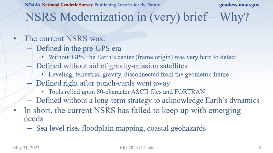
Dru Smith, NSRS modernization manager, started by explaining the practical impact of the modernized NSRS and why it is needed. He mentioned that the current NSRS was defined in the pre-GNSS era and that it has failed to keep up with emerging requirements, such as accurately measuring sea level rise.
(Image: NGS Website)
He highlighted the practical implications of the modernized NSRS, such as that every latitude, longitude, and ellipsoid height will change from its NAD 83 values in the +/-2-meter range, and every orthometric height will change from its NAVD 88 values in the +/-2-meters median range.
He mentioned that the published coordinate functions of the NOAA CORS Network (NCN) will be the primary geodetic control of the NSRS. He noted that NGS is working on the integration of web-based tools to improve consistency and reduce confusion, such as enhancements to NGS’s OPUS to ingest digital data from surveying instruments directly into OPUS 6 via a Geodetic Data Exchange (GDX) format. This would include raw measurements from GNSS receivers, levels, total stations, and gravimeters. The talk titled “Augmenting Data Exchange Formats for OPUS of the Future” by Ryan Hardy, discussed the GDX format in more detail.
As with the International Terrestrial Reference Frame, the modernized NSRS will have a time-dependency component. It will be built into the new NSRS, but users will have the ability to disengage from it.
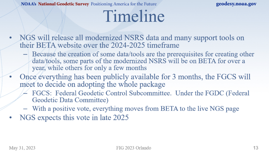
Smith provided a timeline of the project for the next couple of years, which can be referenced in the image below. NGS plans to release data and support tools on their BETA website during 2024 and 2025.
(Image: NGS Website)
Smith discussed how some products will be released early for users to test and evaluate how the new NSRS products will affect their products and services, and to be ready for their customers after the new NSRS is released for publication. Products scheduled for early releases (Alpha Release), include SPCS2022, EPP2022, and GEOID2022.
He emphasized that Alpha products, by definition, can be one or more of the following:
incomplete
inaccurate
buggy
subject to change without notice
As such, their early release is primarily for users to see the “big picture” such as formats of data and the general direction that NGS is taking.
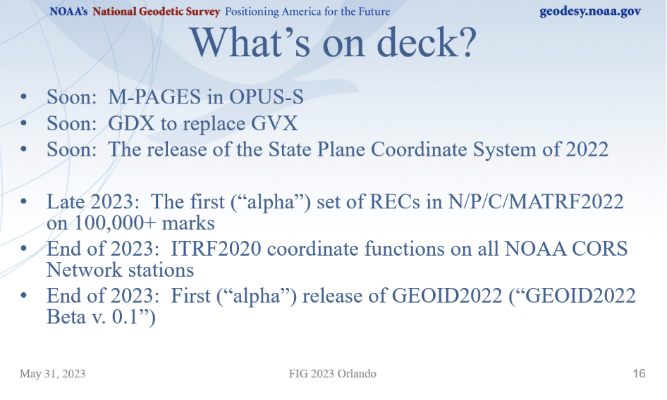
He provided a list of new products that will be announced soon, and some alpha products tentatively planned for release in 2023.
(Image: NGS Website)
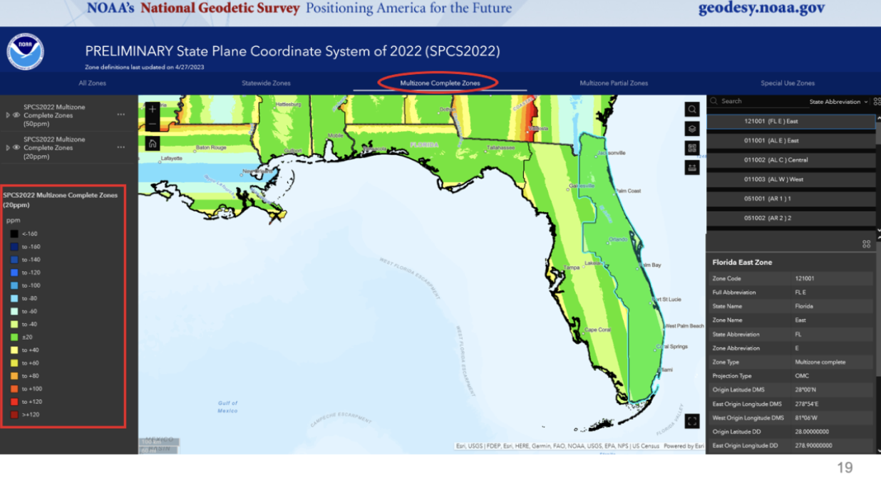
Michael Dennis did a nice job of discussing the State Plane Coordinate System of 2022 (SPCS 2022) and the retirement of the U.S. Survey Foot. He mentioned that the U.S. Survey Foot was superseded by the international foot on December 31, 2022. His presentation gave a brief overview on the status and rollout plans for SPCS2022, along with how and why NGS will continue to support the U.S. Survey Foot in the existing NSRS (but not in the modernized NSRS).
See the image below for the number of zones for each state.
(Image: NGS Website)
The SPCS2022 will be an alpha product released soon. Part of the alpha product will have options to view maps depicting the different zones in each state.
Example of Florida Multizone Complete Zones. (Image: NGS Website)
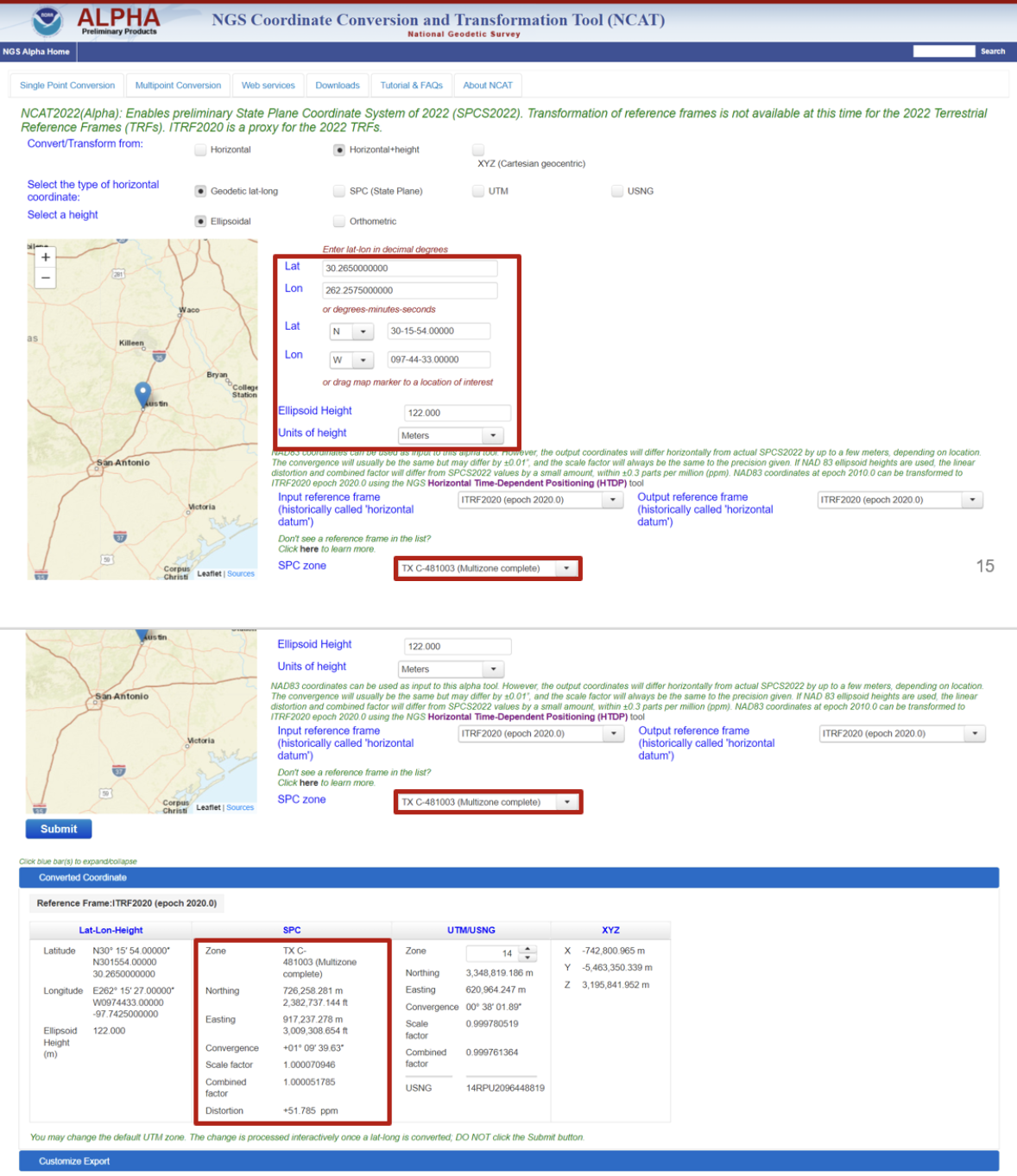
When NCAT2022 is released in alpha product it will contain the SPCS2022.
Example of NCAT2022 (Alpha). (Image: NGS Website)
Representatives from the Canadian Geodetic Survey presented and participated in the discussions.
The session titled “Update on the NOAA CORS Network and OPUS” addressed the following topics:
the NOAA CORS Network (NCN) services
updating OPUS-S to support multi-GNSS
OPUS -Projects 5: supporting RTK for establishment of geodetic control
OPUS projects for manager’s training – transitioning from instructor-led to online, self-paced instruction and
augmenting data exchange formats for OPUS of the future.
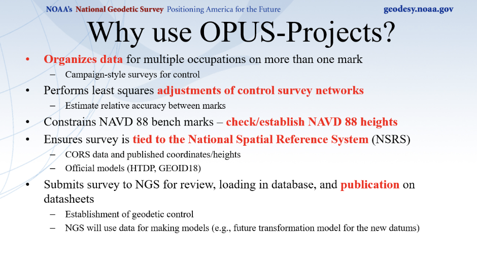
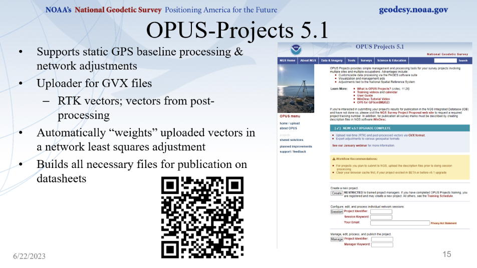
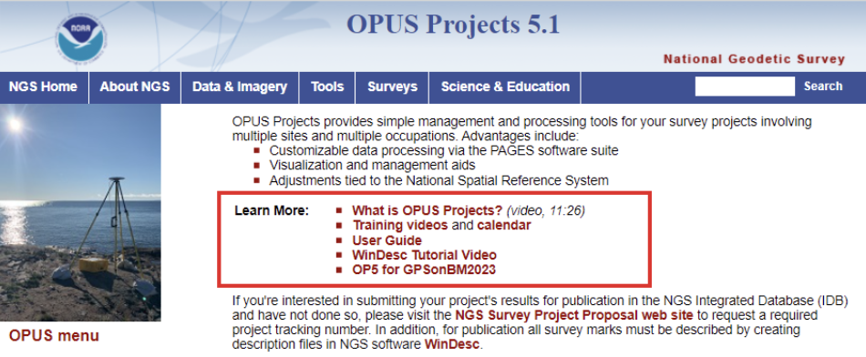
Dan Gillins gave a presentation on the advantages of using NGS’s OPUS-Projects 5 web routine. OPUS-Projects make it easier for users to submit a GNSS project to NGS for publication. I discussed OPUS-Project 5.1, when it was released as a Beta product, in my October 2021 column.
(Image: NGS Website)(Image: NGS Website)
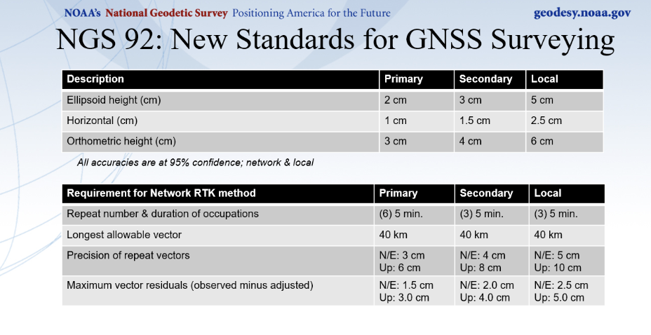
Gillins mentioned that a new publication providing guidance to meet standards for GNSS surveying is being reviewed and will be available soon. I discussed these new standards in my May 2023 column.
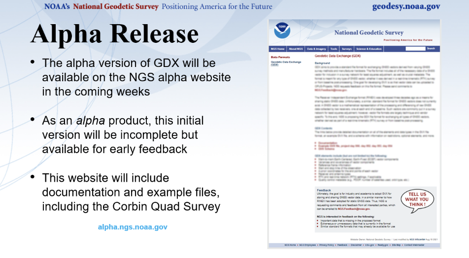
Ryan A. Hardy gave a talk describing the new Geodetic Data Exchange (GDX). As previously mentioned, GDX is an XML-based data format that will be the input format for OPUS. GDX will be the successor to the GNSS Vector Exchange (GVX) format. GDX currently supports GNSS, classical, and leveling measurements.
The GDX structure will have the following fields[[these are clearly the names of database fields; if it were a list of different types of information, we would not put them in all caps and would not use the underscores]]:
SOURCE_DATA
PROJECT_INFORMATION
PERSONNEL
UNITS
EQUIPMENT
POINTS
MEASUREMENT_SETTINGS
MEASUREMENTS
REDUCTIONS
OBSERVATIONS
NGS is planning to release an alpha version of GDX soon.
(Image: NGS Website)
The session titled “Case Studies of Surveys — NGS Does Now and How They will Change” addressed the following topics:
implementing NGS OPUS-Projects’ GVX feature to align RTK vectors to the NSRS to establish geodetic control for FirstNet indoor mapping
IGLD: a case study for leveraging digital tools to enhance QA/QC on large scale static GNSS observation campaigns
geodetic leveling in the modernized NSRS and
NGS field operations: modernizing in many ways.
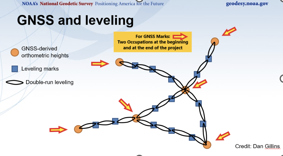
Ben Erickson gave a good presentation on leveling in the new NSRS, a topic about which I am very interested in knowing more[[Please avoid dangling participles, prepositions, conjunctions, and modifiers.]]. I discussed the new procedures in my June 2020 column.
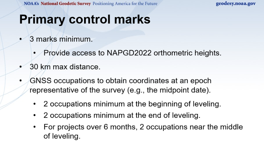
One major change is that leveling surveys will require GNSS occupations to ensure that orthometric heights computed in leveling surveys are up to date and are connected to the NSRS through the NOAA CORS Network. The network accuracy is obtained through GNSS data and a high-accuracy geoid model, and the local accuracy is provided through the leveling data. Specific procedures will be required to incorporate leveling data in the North American Pacific Geopotential Datum (NAPGD2022).
Basic Procedures for NAPGD2022 Orthometric Heights. (Image: NGS Website)
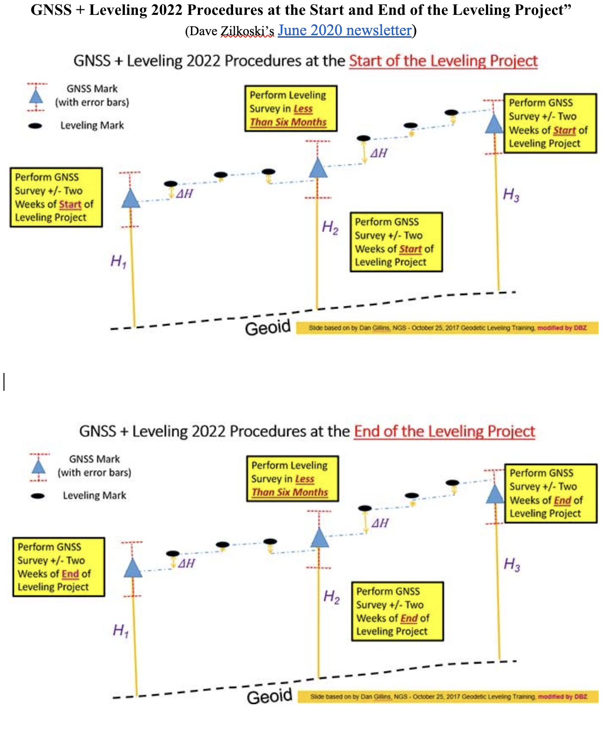
I discussed these procedures in more detail in my June 2020 column. The image below provides a conceptual diagram that illustrates what this means to a typical leveling project.
GNSS + Leveling 2022 Procedures at the Start and End of the Leveling Project”. (Image: Diagram based on information from Dan Gillins, NGS, and modified by David B. Zilkoski)
Erickson provided a diagram of a level network that contained a loop, which can be referenced below.
(Image: NGS Website)
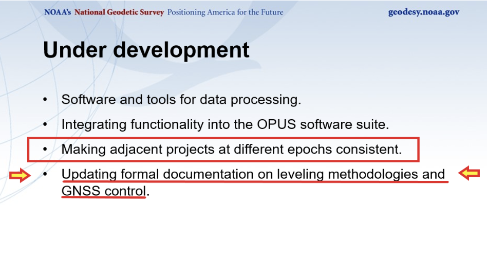
I have worked with leveling data for most of my career and I am pleased to know that NGS is going to provide tools to incorporate leveling data into the new, modernized NSRS. When performing leveling projects, there is a requirement to level to previously established benchmarks that were within a certain distance from the project. This helped to ensure that different leveling projects were consistent with each other. NGS stated that making adjacent projects at different epoch consistent is under development, and their plans include updating leveling documentation to explain the leveling methodologies and GNSS control.
(Image: NGS Website)
I have only highlighted a few of the presentations. It was an all-day session, and a lot of information was presented on the new, modernized NSRS. The presentations can be downloaded from the NGS website at https://geodesy.noaa.gov/datums/newdatums/fig-2023.shtml. I would encourage everyone to download the presentations to obtain the latest information on NGS’s modernization of the NSRS. See the image below for the list of presentations and the links to download specific presentations.
NGS Presentations at FIG 2023 Working Week. (Image: NGS Website)
Air Mobility Event Illustration. (Image: Paris Air Show)
The Paris Air Show
The Paris Air Show rolls out this week, accompanied this year by several urban air mobility (UAM) companies, including Eve Air Mobility with a cabin mock-up of its eVTOL, and demonstrations of its UAM software.
Eve also announced ahead of the show that United Airlines, its major partner, is moving forward with route and infrastructure planning in San Francisco — where such factors as the size of the city and high traffic volume cry out for mobility alternatives.
Eve UAM. (Image: Eve press release)
Emerging as a start-up from within the Brazilian aircraft company Embraer, Eve was eventually floated in 2022 through an initial public offering on the New York Stock Exchange. Given the relationship with Embraer, Eve (in particular, United and other Eve customers) stand to gain access to the worldwide maintenance, support, parts and repair organization that Embraer has developed to support its own passenger fleet of thousands of aircraft. An enviable solution for any current or future purchaser of Eve vehicles — this probably has something to do with their huge order backlog for 2,770 vehicles. All that is required now is the full-scale assembly, ground and flight test, verification and certification of the Eve air mobility aircraft — currently forecast to enable a 2026 entry into service.
Additionally, other UAM companies will be present in a special show exhibit, the “Air Mobility Event,” in Hall 5 in Paris.
Is Ukraine winning the UAV war with Russia?
This is not at all clear, as both sides throw at each other many different UAVs in various configurations with different missions. We tend to only see the Ukraine side of the picture, given that Russia does not generally document its successes in the media.
However, recent news indicates that Moscow is importing Iranian UAV technology to bare in its war with Ukraine. It seems that Iran has been supplying complete kamikaze attack UAVs and may also be assisting with materials to set up an assembly plant near Moscow. Potential one-way attack UAVs include the HESA Shahed 136/Geran-2, the new MERAJ-523 which can carry a 50 kg warhead, and the Mohajer-6 reconnaissance/attack drone.
Last week, Russia unleashed a volley of about 44 UAVs on the capital Kyiv, thought to be Shahed 136 kamikaze UAVs. Ukrainian defenses brought down the majority, but there were still a number of casualties. These attacks on the center of Kyiv are said to have intensified during the last two months — the UAVs are cheap, long range, and carry significant ordinance.
Mohajer-6. (Image: courtesy of the Ministry of Defense of Ukraine)
The UK is reported to have called Iran’s actions in support of Russia contrary to the nuclear agreements reached between Iran and the European Union in October 2022, which prohibit the supply of any military aid to Russia by Iran.
Not to be left behind, India has brought its own kamikaze UAV online
The ALS-50 loitering munition, built by the Mumbai Tata group, was recently inducted into the Indian Air Force (IAF) for use against targets on the ground (i.e., missile batteries) and on the sea (i.e., ships).
With an apparent range of 1,000 km (62 miles) and a payload of 25 kg (55 lb), the Indian-produced UAV will replace more expensive UAVs, which India has imported from Poland and elsewhere.
With the war in Ukraine on the mind of all countries near the conflict, it is clear that many may take on defense strategies similar to those that have been used by both Russia and Ukraine.
UAV news summed up
So, as the International Paris Air Show, previously a major military exhibition and air show, begins to welcome and feature the coming age of UAM, it is good to see that there are several independent programs that plan to show their wares. Air-taxi services are still some way off from being a reality, as there are still heavy, lengthy investments to be made in building and qualifying these unmanned/manned aircraft for passenger use. Hopefully, however, several of the contenders will make it to the finish line and fulfill the promises made for UAM.
Meanwhile, as the war in Ukraine plods along, taking lives and destroying property, it is good that both sides have decided that UAVs should be the way to proceed. UAVs, after all, are relatively small and the degree of destruction they can cause is limited. Still, this is not very comforting for people on both sides as they run from the sound of two-stroke and four-stroke engines descending from on high, carrying explosive charges that will kill and maim. Additionally, as the West arms Ukraine with defensive materials, it’s not surprising that Russia is seeking weapons from allies, wherever it can find them.
A business-to-business, controlled-circulation magazine such as this one is a three-way partnership between the companies that support it by buying ads; the staff who write, edit and lay out the magazine’s editorial content, write a steady stream of posts for our website and digital newsletters, and sell advertising; and you, the readers, without whom we would not exist.
There are more than 30,000 of you who subscribe to the magazine (more than 17,000 to the print edition and more than 18,000 to the digital edition, with some overlap). Additionally, our website has about 97,000 unique monthly visitors, our e-newsletters have about 92,000 monthly subscribers, and we have about 46,000 social media followers. About 30% of you are in surveying and mapping, 18% in defense and government, 13% in professional and consumer OEM, and others in transportation, wireless/location-based services, distribution and resale, machine control and precision agriculture, and system design and testing.
You’re a large pool of knowledge, experience, and insight. I want to invite you to contribute to GPS World as sources, advisers and writers.
Perhaps you are a retired engineer with decades of experience designing receivers, antennas, or navigation systems and would like to share a few of the lessons you’ve learned. Perhaps you are a surveyor with a wish list of features for the next generation of rovers. Perhaps you are the manager of a port that uses GNSS to automate ship loading and unloading operations, or of a farm that relies on precision agriculture, and you have some observations worth sharing about your return on investment.
If you are a professor of engineering, you might want to bring to my attention a particularly promising student project. If you develop consumer products or positioning and navigation solutions for mass transit, or timing solutions for the financial sector, you might have interesting insights to share.
Alternatively, perhaps you would like to propose a question for our editorial advisory board, or a topic for the next installment of our “Authoritative Reference” series. Of course, occasionally you might also want to point out errors or omissions in one of our published articles or online posts. I welcome that feedback, too.
We already work with the marketing and media relations staff of our marketing partners, as well as public relations firms that represent GNSS/PNT companies. I always welcome their email messages and calls. This is not intended as an additional channel for them. I am also not setting up a discussion forum, because that would require content moderation and backend IT resources. Rather, I want to solicit comments, suggestions and interesting, useful content from people throughout the industry — some of which will guide or inspire my editorial choices and some of which I will publish.
We have limited room in print, but plenty online. Therefore, while I will occasionally work with the author of a particularly interesting or informative piece to generate an article for print publication, I will much more often choose articles, columns, and comments for online publication.