Category: Uncategorized

  • Report: Commercial UAV market to reach $2 billion by 2022

    Report: Commercial UAV market to reach $2 billion by 2022


    The global commercial UAV market is expected to reach $2.07 billion by 2022, according to a new study by Grand View Research Inc.

    Increasing applications in agriculture and law enforcement are expected to drive commercial UAV industry growth over the forecast period. Commercial drones are finding applications across various industry verticals globally. Every industrialized country in the world is making investments in drones, thus driving the scope and technological developments for applications in the commercial UAV market.

    Drones are contemporary alternatives for activities where human life cannot be risked. Such drones find applications in various industrial verticals including military, homeland security, retail and agriculture. The demand is significantly higher for military applications, although commercial applications are progressively catching up.

    Aviation regulatory bodies such as the Federal Aviation Administration (FAA) have imposed restrictions on the use of such drones taking into consideration the difficulties in managing such huge air traffic and the safety of the citizens. However, the FAA is known to be undertaking an initiative to accelerate the UAV approval process for public safety agencies and broaden access to civilian organizations for a variety of commercial, industrial and other applications.

    Further key findings from the report suggest:

    • Rotary blade drones accounted for more than 70 percent of the global market share owing to their easy maneuverability and compact design. Moreover, such single and multi-rotor drones equipped with rotary blades have Vertical Take-Off and Landing (VTOL) abilities for applications, where there is limitation of space for fixed blade drones to take off. The development of advanced hybrid UAVs that operate on non-conventional sources of energy and nano, small miniature drones serve multiple applications across various industry verticals.
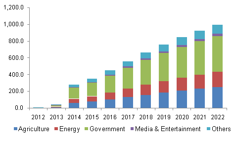
    • Government applications dominated the global commercial UAV industry constituting more than 40 percent of the market share in 2014. Increasing applications in law enforcement, security and surveillance, R&D activities, infrastructure, disaster management, and environmental studies have led to an increased demand for such unmanned aerial vehicles from the concerned government agencies. Innovative applications across agricultural sector have made it the fastest growing application segment, which is projected to grow at a CAGR of more than 18 percent from 2015 to 2022. Special agricultural drones can take snapshots of fields and help in analyzing crops. In addition, fix winged drones can be used for applications such as watering, spreading seeds, fertilizers, and pesticides over large farm fields that drastically reduce the time required and increase the efficiency.
    • North America is expected to grow at a CAGR of more than 16 percent over the forecast period on account of concentration of major drone manufacturers and increasing applications in the commercial sectors in the region. Governments and technology giants across the world are striving hard to provide internet to the people as a basic necessity. Facebook Inc. recently acquired Ascenta, a drone manufacturer for its pilot project to provide internet in remote areas using drones as movable wireless access points. Relaxation in regulations and increasing use of drones in law enforcement activities in Europe have led to the regional industry growth.
    • Major industry participants include AeroVironment Inc., BAE Systems, DJI, Elbit Systems, Parrot SA, Israel Aerospace Industries, The Boeing Company, and Textron Inc. Manufacturers resort to mergers and acquisitions as their key growth strategy to make their presence felt in the industry. Augmented funding, technological collaborations, and government agencies are expected to emerge as critical success factors for industry growth.

    Grand View Research has segmented the global commercial UAV market on the basis of product, application, and region:

    • Commercial UAV Product Outlook (revenue, USD billion, 2012-2022)
      • Fixed wing
      • Rotary blade
      • Nano
      • Hybrid
    • Commercial UAV Application Outlook (revenue, USD billion, 2012-2022)
      • Agriculture
      • Energy
      • Government
      • Media & Entertainment
      • Others
    • Commercial UAV Regional Outlook (revenue, USD billion, 2012-2022)
      • North America
      • Europe
      • Asia Pacific
      • Latin America
      • MEA

    Learn more about the report here.

  • New Navia GLONASS navigation receiver released

    New Navia GLONASS navigation receiver released

    GLONASS module Navia NL3333The new GLONASS module Navia NL3333 has been released by the EuroMobile Wireless Solutions Company. The module is made in an original 8.7 millimeter by 9.5 millimeter form-factor on the base of MediaTek MT3333 chipset. The manufacturer has achieved reduced dimensions, as well as significant reduction in a power consumption compared with previous Navia modules. In all such significant improvements, according to the manufacturer, the price remains at an accessible level.

    Compared with other modules, the Navia NL3333 has a more flexible power scheme, with an active antenna power supply displayed on the additional output. This allows the customer to save space on the board using a passive antenna or install the necessary RF isolation (inductance) when an active antenna is necessary.

    Though labeled a GLONASS receiver, the Navia uses all of the GNSS constellations: GPS, GLONASS, Galileo, QZSS and BeiDou. NL3333 has high sensitivity and fast time to first fix (TTFF). The module includes a noise reduction 12-step system. The module power range is 2.8 – 4.2 V, which can successfully be used in projects powered by Li-Pol batteries. The module connection is via UART, and the data are issued by NMEA protocol.

    The EuroMobile Wireless Solutions Company will display its latest developments at booth 81В40 at the 2016 Navitech exhibition, which will be held May 10-13 at the Expocentre Fairgrounds in Moscow.

  • Spirent Issues Ebook on Testing Drones, UAVs

    Photo: Spirent

    Spirent has issued a free new 28-page ebook designed to provide An Introduction to Testing Navigation and Positioning Performance in Drones, UAS and UAVs.

    According to Spirent, “The use of unmanned aerial vehicles (UAVs) is starting to take off in commercial and military sectors. The potential applications of UAVs are many – including survey, mapping, media reporting, delivery, reconnaissance, conservation and search & rescue. What’s more, in some cases the cost of using UAVs has been found to be up to 98.8% cheaper than manned aircraft.

    “But it is still early days, and for designers and developers of UAVs, there are many challenges in bringing viable models to market and putting them to work.”

    The ebook looks at those challenges and sets out the main positioning and navigation considerations that UAV test teams should incorporate into their test regime, Spirent said. It covers:

    • GNSS/GPS performance considerations — how to evaluate positioning capabilities of UAVs
    • UAV design considerations, including where GNSS receivers should be placed, the type of antenna needed and more
    • Which environmental/external factors need to be considered, such as wind, temperature and multipath effects
    • Compliance considerations.

    The ebook can be ordered through Spirent.

  • Bentley Systems offers new sewer and stormwater products


    StormCAD from within OpenRoads.
    StormCAD from within OpenRoads.

    Bentley Systems’ latest infrastructure products are now available. They include SewerGEMS, SewerCAD, StormCAD and CivilStorm V8i (SELECTseries 5) products for the analysis and design of wastewater and stormwater systems. All of the V8i (SELECTseries 5) sewer and stormwater products can be used as stand-alone products, or be run on CAD and GIS platforms.

    They can also now be used from within the V8i (SELECTseries 4) versions of OpenRoads-based products — combining 3D design and hydraulic analysis capabilities in the same platform. The resulting comprehensive civil solution eliminates the need for extra import/export steps or file conversions, Bentley Systems said.

    “The integration of Bentley’s OpenRoads civil design functionality with the advanced capabilities of Bentley’s storm and sewer analysis products will be a huge benefit to productivity and quality for our highway drainage design workflows,” said Chris Haines, senior civil engineer and PAR-BIM technical lead, Drainage and Utilities, Parsons.

    Terrain model elevations on profiles.
    Terrain model elevations on profiles.

    “With these new releases, the automated hydraulic design functionality of our sewer and storm products can be effortlessly combined with the 3D physical design and terrain modeling capabilities of Bentley’s other civil products,” said Gregg Herrin, Bentley Systems director of product management, hydraulics and hydrology. “From an information mobility standpoint, this has a direct and substantial positive impact on roadway, site and municipal work where hydraulic engineering is just one part of a much larger project.”

    Bentley’s SewerGEMS, SewerCAD, StormCAD and CivilStorm V8i (SELECTseries 5) products provide the following capabilities:

    • Ground elevations from terrain models may be used during automated design runs to consider “cover” along a pipe’s length, improving decision making related to system design.
    • Terrain model elevations can also now be added to profiles, improving the resulting visualization and the user’s understanding of the physical network.
    • New low-impact development (LID) elements are now available, making it easier to model a wider range of controls for stormwater management.
    • With the new lateral link element, engineers can include lateral pipes in their hydraulic analysis without creating “fake” elements where the laterals connect to the main pipe.
    • Easy access to the Bentley Communities professional networking site is embedded within the applications, facilitating communications between users and Bentley’s hydraulic modeling experts.

    Users of any of these SELECTseries 5 releases now benefit from the products’ support of MicroStation V8i (SELECTseries 3), OpenRoads V8i (SELECTseries 4), AutoCAD 2015 and 2016, and ArcGIS 10.2 and 10.3 (SewerGEMS only), giving them the ability to model from within the latest MicroStation, OpenRoads, AutoCAD or ArcGIS version.

  • NVS Technologies Releases L1 RTK Receiver

    NVS Technologies Releases L1 RTK Receiver

    NVS TechnologiesNVS Technologies AG has launched an L1 RTK+Heading GNSS receiver. The NV08C-RTK-A is fully integrated multi-constellation satellite navigation receiver with embedded RTK functionality and compatibility with GPS, GLONASS, Galileo and BeiDou.

    NV08C-RTK-A is specifically designed for use in high-accuracy applications, demanding low-cost, low-power consumption, small form factor and high performance, such as construction, mining and industrial; environmental and structural monitoring; machine control and automation; parallel driving systems; precision agriculture; UAVs; and robotics and intelligent machines.

    More Features

    • L1 GPS, GLONASS and SBAS
    • Centimeter-level positioning in RTK mode
    • Enhanced RAIM for 3D and RTK modes
    • Three-stage filtration for high out-of-band interference immunity
    • Industrial operating temperature range -40°C to +85°C
    • Low power consumption
    • Integrated MEMS-sensors (INS)

  • U.S. Forest Service Deploys Avenza PDF Maps App for Firefighting

    U.S. Forest Service Deploys Avenza PDF Maps App for Firefighting

    A San Juan interagency hotshot crew member refers to a map on his iPad as he coordinates execution of their burnout operation.  (Photo credit: Esther Godson)
    A San Juan interagency hotshot crew member refers to a map on his iPad as he coordinates execution of their burnout operation.  (Photo credit: Esther Godson)

    Every year thousands of acres of forests are engulfed in fires. Recognizing the benefits of geospatial technology, the United States Forest Service (USFS) Geospatial Management Office (GMO) is using Avenza System Inc.’s award-winning PDF Maps mobile app to deliver interactive digital maps to firefighters and emergency response teams situated in forests across the United States and its territories.

    The USFS fights wildfires and other natural disasters in more than 155 national forests and 20 national grasslands, totaling an estimated 193 million acres or 30 percent of all federally managed lands. The USFS GMO is responsible for the implementation of the Forest Service geospatial program which includes using technologies such as GIS, remote sensing, cartography, geodesy and GPS.

    The centered blue GPS position on an operations map pinpoints the user’s location. (Photo credit: Carl Beyerhelm)
    The centered blue GPS position on an operations map pinpoints the user’s location. (Photo credit: Carl Beyerhelm)

    With increased use of digital solutions, the USFS benefits from Avenza’s PDF Maps app geospatial technology in enabling its thousands of firefighters and support personnel. The PDF Maps app aids emergency response teams who use digital devices for work in the field.

    The app provides constant access to geographic information and points of interest, with additional interactive features such as measuring, place marking and location tagging. The app operates without the risk of lost reception due to cell tower proximity and does not rely on an Internet connection to use map data. It uses GPS to obtain and display an accurate position on the ground regardless of network connectivity.

    A hardcopy map is compared to its digital counterpart cached on a smartphone. (photo credit: Kari Greer)
    A hardcopy map is compared to its digital counterpart cached on a smartphone. (photo credit: Kari Greer)

    “Accessing maps on mobile devices ensure responders have accurate and current geographic information while they’re out in the field,” said Carl Zulick, Geospatial Information Officer, USFS. “Avenza’s PDF Maps app makes it possible for teams to use any map digitally without requiring a data connection while involved in an emergency situation. Since the maps are location-aware and interactive, we can capture real-time data, photos, and locations. This data can be shared to assess the situation and make necessary strategic changes and improve situational awareness.”

    The PDF Maps app is available now on the iTunes App Store and Google Play Store free of charge for personal recreational use. A Windows version is currently in public beta release. Commercial, government and academic use licensing is available for a nominal annual fee. Pricing of each map is set by the publisher and free maps remain free to users through the PDF Maps app in-app store. Commercial use licensing starts at US$49 per year and drops on a per-device basis as deployment numbers increase.

    Mobile maps help air-tanker pilots avoid the mapped yellow areas, where application of aerial fire retardant is restricted. (Photo credit: Max Wahlberg) 
    Mobile maps help air-tanker pilots avoid the mapped yellow areas, where application of aerial fire retardant is restricted. (Photo credit: Max Wahlberg)
  • U.S. Forest Service deploys Avenza PDF Maps app for firefighting

    A San Juan interagency hotshot crew member refers to a map on his iPad as he coordinates execution of their burnout operation.  (Photo credit: Esther Godson)
    A San Juan interagency hotshot crew member refers to a map on his iPad as he coordinates execution of their burnout operation.  (Photo credit: Esther Godson)

    Every year thousands of acres of forests are engulfed in fires. Recognizing the benefits of geospatial technology, the United States Forest Service (USFS) Geospatial Management Office (GMO) is using Avenza System Inc.’s award-winning PDF Maps mobile app to deliver interactive digital maps to firefighters and emergency response teams situated in forests across the United States and its territories.

    The USFS fights wildfires and other natural disasters in more than 155 national forests and 20 national grasslands, totaling an estimated 193 million acres or 30 percent of all federally managed lands. The USFS GMO is responsible for the implementation of the Forest Service geospatial program which includes using technologies such as GIS, remote sensing, cartography, geodesy and GPS.

    The centered blue GPS position on an operations map pinpoints the user’s location. (Photo credit: Carl Beyerhelm)
    The centered blue GPS position on an operations map pinpoints the user’s location. (Photo credit: Carl Beyerhelm)

    With increased use of digital solutions, the USFS benefits from Avenza’s PDF Maps app geospatial technology in enabling its thousands of firefighters and support personnel. The PDF Maps app aids emergency response teams who use digital devices for work in the field.

    The app provides constant access to geographic information and points of interest, with additional interactive features such as measuring, place marking and location tagging. The app operates without the risk of lost reception due to cell tower proximity and does not rely on an Internet connection to use map data. It uses GPS to obtain and display an accurate position on the ground regardless of network connectivity.

    A hardcopy map is compared to its digital counterpart cached on a smartphone. (photo credit: Kari Greer)
    A hardcopy map is compared to its digital counterpart cached on a smartphone. (photo credit: Kari Greer)

    “Accessing maps on mobile devices ensure responders have accurate and current geographic information while they’re out in the field,” said Carl Zulick, Geospatial Information Officer, USFS. “Avenza’s PDF Maps app makes it possible for teams to use any map digitally without requiring a data connection while involved in an emergency situation. Since the maps are location-aware and interactive, we can capture real-time data, photos, and locations. This data can be shared to assess the situation and make necessary strategic changes and improve situational awareness.”

    The PDF Maps app is available now on the iTunes App Store and Google Play Store free of charge for personal recreational use. A Windows version is currently in public beta release. Commercial, government and academic use licensing is available for a nominal annual fee. Pricing of each map is set by the publisher and free maps remain free to users through the PDF Maps app in-app store. Commercial use licensing starts at US$49 per year and drops on a per-device basis as deployment numbers increase.

    Mobile maps help air-tanker pilots avoid the mapped yellow areas, where application of aerial fire retardant is restricted. (Photo credit: Max Wahlberg) 
    Mobile maps help air-tanker pilots avoid the mapped yellow areas, where application of aerial fire retardant is restricted. (Photo credit: Max Wahlberg)
  • UAS Registration Task Force Members Announced

    Federal Aviation Administration (FAA) Administrator Michael Huerta has announced the membership of the Unmanned Aircraft Systems (UAS) Registration Task Force. Earl Lawrence, director of the FAA’s UAS Integration Office, and Dave Vos of Google X will co-chair the group.

    Department of Transportation (DOT) Secretary Anthony Foxx and Administrator Huerta announced the formation of the Task Force on Oct. 19. The Task Force membership represents a range of stakeholder viewpoints, interests and knowledge of the objectives and scope. Task Force membership was by invitation only and participation is voluntary.

    Interested parties who are not members of the Task Force may submit comments to the public docket. The Federal Register notice is available for viewing here.

    Sec. Foxx set a deadline of Nov. 20 for the Task Force to complete its recommendations, and work is already underway. The group will meet formally from Nov. 3-5 before developing recommendations on a streamlined registration process and minimum requirements on which unmanned aircraft should be registered. Given the urgency of this issue, the DOT and FAA will move expeditiously to consider the Task Force’s recommendations.

    Along with the FAA and DOT, the following federal agencies will provide expert support to the Task Force: Department of Commerce, Department of Defense, Department of Homeland Security, Department of the Interior, Office of Management and Budget, National Aeronautics and Space Administration and the Department of State.

    Task Force Members

    Nancy Egan – 3D Robotics
    Richard Hanson – Academy of Model Aeronautics
    George Novak – Aerospace Industries Association
    Chuck Hogeman and Randy Kenagy – Air Line Pilots Association
    Jim Coon – Aircraft Owners and Pilots Association
    Sean Cassidy – Amazon Prime Air
    Ben Gielow–Amazon Retail
    Justin Towles – American Association of Airport Executives
    Brian Wynne – Association of Unmanned Vehicle Systems International (AUVSI)
    Parker Brugge – Best Buy
    Douglas Johnson – Consumer Electronics Association
    Brendan Schulman – DJI
    Paul Feldman – General Aviation Manufacturers Association
    Dave Vos – GoogleX (Co-Chair)
    Tony Bates – GoPro
    Matt Zuccaro – Helicopter Association International
    Mike Fergus – International Association of Chiefs of Police
    John Perry – Management Association for Private Photogrammetric Surveyors (MAPPS)
    Brandon Declet – Measure
    Randall Burdett – National Association of State Aviation Officials
    Sarah Wolf – National Business Aviation Association
    Baptiste Tripard – Parrot
    Tyler Collins – PrecisionHawk
    Gregory McNeal – Small UAV Coalition
    Thomas Head – Walmart

  • OriginGPS Introduces Modules to Support GPS, GLONASS and BeiDou with MediaTek

    OriginGPS has launched a new family of products, the first of which is the ORG1510-MK Multi Micro Hornet, a fully integrated multi-GNSS (GPS, GLONASS and BeiDou) module. The miniature low-power architecture supports an update rate of up to 10 Hz and contains onboard flash. It is designed to provide a GNSS component to devices that require fully featured components with small footprints, such as UAVs designed to follow action sports and other fast-moving activities or wearables.

    OriginGPS released the Multi Micro Hornet (ORG1510-R01) in June, which tracks GPS and GLONASS, but not BeiDou. The ORG1510-R01 uses a SiRFstarV GNSS system on chip.

    The ORG1510-MK contains the MediaTek MT3333 chip, which supports a fast update position calculation rate. The chip also contains an onboard flash memory that does not erase when power is off. It consumes very little power with the use of both standby mode and backup mode, and, in advanced applications, a periodic mode that can turn the device on and off when in backup or standby.

    “The inclusion of MediaTek has enabled the creation of the most powerful GPS module on the market,” said Gal Jacobi, CEO of OriginGPS. “The ORG1510-MK’s tremendously fast update rate, low power consumption, miniature size and reliable accuracy makes it possible to track life’s most exciting and fast-paced activities without delay, battery drain, or clunky devices. It will be a meaningful engine of growth for OriginGPS in Asia Pacific and globally.”

    Key features of the New Multi Micro Hornet include:

    Rapid update rate and superior memory – The Multi Micro Hornet has an update rate of up to 10 Hz and onboard flash, supporting a significantly higher accuracy than the standard update rate of 1 Hz and low power consumption due to the module’s ability to store hours of data.

    Smallest size, highest performance – Despite the Multi Micro Hornet’s tiny size of 10 x 10 mm and height of 6.1 mm, the module offers superior sensitivity and outstanding performance, achieving rapid time to first fix (TTFF) of less than 1 second, accuracy within as little as 1 meter, and sensitivity at -165 dBm for two constellations simultaneously.

    High sensitivity and noise immunity – The ORG1510-MK continues to leverage OriginGPS’ patented and proprietary Noise Free Zone (NFZ) technology to ensure high sensitivity and noise immunity even under marginal signal conditions.

    Continuous connectivity with minimal power consumption – The low power consumption modes aided by MediaTek include a standby mode, during which the RF and baseband enter low power mode, and backup mode, during which the internal PMU turns off and only keeps the VRTC domain alive. For advanced applications, the module can periodically turn its operation on and off when in backup or standby mode.

    An intelligent design that shortens time to market – The Hornet family of GPS / GNSS antenna modules integrates a GNSS receiver and patch antenna in a single module. As a cornerstone of the OriginGPS portfolio, the ORG1510-MK pin-to-pin compatibility with the Micro and Nano Hornet modules ensures a seamless migration from GPS to GNSS and gives developers the ability to create new product offerings in the shortest time to market while minimizing costly design risks. Developers can simply connect it to a power source on a single layer PCB to begin integrating it into their designs.

    The ORG1510-MK module combines OriginGPS’ proprietary low-profile GNSS antenna with a dual-stage LNA, RF LDO, SAW filter, TCXO, RTC crystal and RF shield.

  • SkyPixel Announces Drone Photography Competition

    SkyPixel

    SkyPixel, an aerial photography community run in cooperation with DJI, has announced a drone photography competition. The 2015 SkyPixel Photo Contest is accepting entries starting Monday, Oct. 26, at 00:00 Hong Kong time (GMT+8). Prizes include cash and DJI drones and related equipment.

    The contest invites both budding and professional aerial photographers to enter a selection of their best work. The competition is split into two groups, Professional and Enthusiast, each with their own awards for the following categories: Beauty, Unique Dronies, and Drones in Use (aimed at showcasing drones in the air), in addition to an overall Grand Prize.

    To celebrate the rise and popularity of aerial photography, the Popular Award will be given to the contest’s 10 most popular photos, based on number of likes received on SkyPixel. Winners will be announced on Jan. 7, 2016.

    SkyPixel users can submit their entries at the competition page.


  • Red Hen’s MediaMapper Highlighted at GEOINT Program

    Red-Hen-MediaMapper-O

    Bruce Donaldson of Red Hen Systems LLC gave a presentation about MediaMapper Mobile, an Android app with extensive utility for ISR professionals and civilians, on a panel at the Innovative GEOINT Application Provider Program (IGAPP). IGAPP was held in St. Louis on Oct. 20. Donaldson is Red Hen’s Intelligence Surveillance and Reconnaissance (ISR) manager.

    During his years of field service, Donaldson worked to address the need for Mobile Geo-Intelligence platforms that can rapidly collect, process and disseminate geospatial data and other multimedia within 24 hours of a mission.

    Red_Hen_MediaMapperAt its essence, MediaMapper Mobile enables users to:

    • Geotag video, photos, audio and other notes. Annotate ground track logs. Create audio and visual notes connecting them to points of interest. Tag features from a touchscreen.
    • See track log (a.k.a breadcrumb trail). View on a map along with GPS details about location, including latitude, longitude, and altitude. Inspect media objects and other sensor streams. Share with others with XML and KML/KMZ.
    • Use with Vectronix, LTI or Trimble laser rangefinder (compass, tilt, range, calibration). Or, triangulate your location by taking two or more photos of the same object. Once the feature is identified in these images, MediaMapper Mobile will do the calculation to show you where the object was and where you were when you took the photos.
    • Configure settings for GPS devices, cameras, shuttering automations for intervalometry (time/distance).
    • Log files, manage collection projects, and complete inspection forms on site.
    • Transfer your raw multimedia data files and their track logs from your Android device to a laptop, tablet or server to view and analyze on Google Earth, Esri ArcGIS, FalconView or MediaMapper for desktop.
    • Patrol/Event Recorder with NMEA compliant record schemas compatible to MediaGeotagger and GEM2MISB for Esri ArcGIS and the free Full Motion Video module.

    MediaMapper Mobile is available at the Google Play store. For more information, call Ellen Skinner at 970-344-6290 or email [email protected].

  • Leica Geosystems, NCTech Streamline Workflows, Improve Productivity

    Leica-Cyclone-panorama-O

    Leica Geosystems has teamed with NCTech, developer of reality imaging systems, to deliver automated, colorized 3D point clouds. In Leica Cyclone, 3D point cloud processing software, users can now automatically import and align high-dynamic range (HDR) data from NCTech’s iSTAR camera database, producing enhanced deliverables quicker and easier, Leica Geosystems said.

    “It is not only about attractive images but also the accuracy to which these images fit the 3D point cloud data that is paramount, and NCTech’s iSTAR camera produces high-quality HDR imaging at the accuracy everyone expects,” said Faheem Khan, vice president, business development for Leica Geosystems High-Definition Surveying (HDS). “Including this capability directly into Leica Cyclone provides fully optimized workflows for maximum productivity. This starts from data collection through to deliverable production that leverage new products, such as Leica TruView Global and JetStream to tackle the increasingly complex challenge of multi-platform, multi-device and multi-discipline project delivery.”

    Previously, Leica Cyclone users accessed iSTAR imagery database through NCTech’s ColourCloud software application, which produced colourised point clouds in E57 format. With the new partnership, export and re-import of this highly-accurate data is eliminated, speeding up and simplifying the overall 3D point cloud creation process.

    “We are excited to collaborate with Leica Geosystems on this development, which provides direct access for Leica Cyclone users across the world to colourise their point clouds using iSTAR’s panoramic HDR imaging,” said Cameron Ure, CEO of NCTech. “With our iSTAR products, we are focussed on capturing the most accurate colour data as rapidly as possible, and everyone benefits when that data is seamlessly integrated into our partners’ applications.”

    Photo: Leica Geosystems