After a two-week delay, a rocket carrying a GPS instrument designed by University of New Brunswick scientists was launched into space aboard the SpaceX Falcon 9 rocket on September 29. The rocket left Vandenberg Air Force base in California as part of the CASSIOPE (Cascade Smallsat and Ionospheric Polar Explorer) mission.
Dr. Richard Langley, GPS World Innovation editor and professor in geodesy and geomatics engineering at the University of New Brunswick, is a principal investigator behind the scientific portion of the CASSIOPE mission. Langley and his colleagues will monitor data from the GPS instrument, which is part of the Enhanced Polar Outflow Probe (e-POP) payload aboard the spacecraft.
E-POP will continue the sequence of Canada’s orbiting space environment sensors, which began with Canada’s first satellite, Alouette 1, launched in 1962 to study the ionosphere. e-POP is, perhaps, the most extensive suite of sensors for studying the ionosphere/magnetosphere/thermosphere yet to be launched, and will provide Canadian and other scientists with the opportunity to better understand the impact and variability the sun has on the space environment — what we call “space weather.”
A static fire retested the Falcon 9 rocket after several problems cropped up during a hotfire of the launcher’s engines during preparation for the original launch date September 15. The launch was then delayed because the U.S. Air Force Western Range, which controls a network of tracking and communications assets based at Vandenberg, was busy with Minuteman ballistic missile testing.
The small hybrid satellite blasted off on board a Falcon 9 rocket developed by SpaceX, a commercial space company. The Canadian Space Agency became one of SpaceX’s first customers when the agency decided years ago to use the private U.S. rocket to deliver the satellite at a reduced cost of $10 million. It cost the space agency $63 million to develop the satellite.
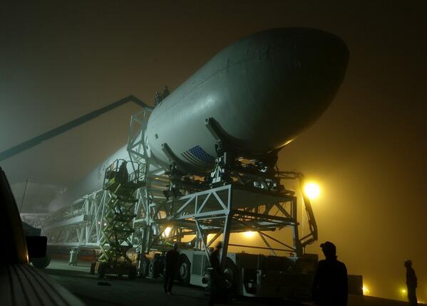
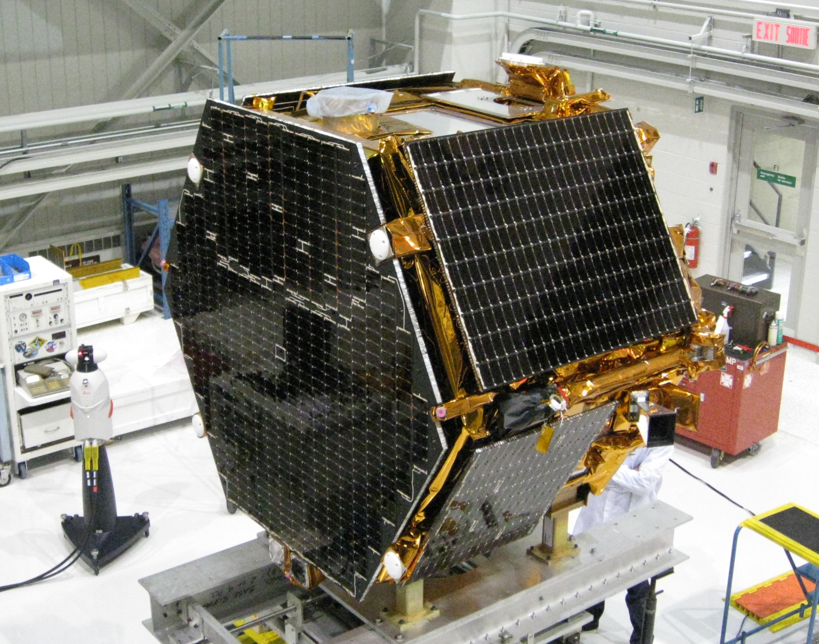
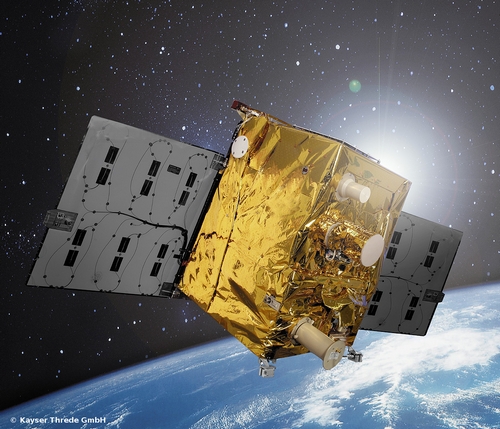
The Falcon 9 rocket, with CASSIOPE inside its fairing, on the way to the launch pad at Vandenberg Air Force Base. (Photo credit: SpaceX).The research satellite CASSIOPE on a test platform at the Canadian Space Agency’s David Florida Laboratory. CASSIOPE hosts the GPS Attitude, Positioning, and Profiling instrument designed by GGE researchers. The four white antennas on the left-facing side of the spacecraft will be used to determine the position, velocity, and attitude of the spacecraft while the antenna on the upper side will be used to profile the ionosphere’s electron density. (Photograph courtesy of MacDonald, Dettwiler and Associates Ltd.)
BioDigital, Inc. announced they’ve received $4MM in Series A funding led by FirstMark Capital with participation from the NYU Venture Fund and a number of prominent angel investors.
According to the announcement, BioDigital has been pioneering the use of 3D technology to simplify health concepts for a decade. Regardless of the customer the underlying problem remained the same: traditional methods of communicating health information were no longer adequate. Furthermore, the consumer appetite for information is unprecedented, but the format its delivered in is hard to digest. 3D technology has already changed the face of games, movies and with geo-browsers like Google Earth the way we navigate our planet, but nowhere does 3D make more sense than in representing the human body. The body is a dynamic, complex system and understanding it using text and static 2D illustration is inherently flawed. BioDigital has been fortunate over the last decade to provide innovative solutions to this problem to a range of healthcare customers such as hospitals, medical schools, device and pharma.
Two years ago, BioDigital reports that it saw some profound changes happening in the development of the Web. For the first time, as part of the HTML5 spec, 3D would be natively supported in browsers. Cloud and API based businesses also emerged. BioDigital opines that technology is clearly entering a new phase of the web: a services oriented model which leverages rich interactive media as a better means of conveying information. BioDigital reports these trends inspired it to take its IP built over the years and create the definitive place for immersive health content on the Web, which is called the BioDigital Human Platform.
BioDigital reports that since its launch 12 months ago, the Human has exceeded expectations. More than one million members have joined across an array of use cases. Students from over 2500 schools are using it to learn anatomy; consumers are using it to understand and share everything from fitness to health conditions; healthcare providers are now introducing it within their clinics to better communicate with their patients.
Building the first true 3D virtual body platform that finally allows people to see what’s happening below our skin is a massive undertaking, according to the company blog. BioDigital says the investment will allow it to accelerate the development of features and API functionality requested by its users while furthering its mission to make health and human body understandable to everyone.
NASA’s Earth Observatory released images illustrating the September floods in Colorado. Though water levels on the South Platte River were receding, muddy brown waters were still out of the river’s banks near Greeley, Colorado, on September 17, 2013, when the Operational Land Imager (OLI) on the Landsat 8 satellite acquired this image. At the time, the river was more than six feet above flood stage, down from more than eight feet above flood stage.
The image shows that the flood has washed away roads, including sections of U.S. Highway 34. Farmland and a few developed areas are under water. Heavy rain caused flooding across the Front Range of the Rocky Mountains starting on September 11, and much of that water made its way into the South Platte River. The river reached a record 18.79 feet in the early morning hours of September 14. The previous record crest was 11.73 feet. Flood stage is 10 feet. As the water subsides in Colorado, it is expected to swell the river downstream in Nebraska.
Image acquired by NASA June 29, 2013Image acquired by NASA September 17, 2013
According to the announcement, as of September 18, floods had affected 17 counties in Colorado, leaving six people dead, 306 missing, and more than 18,000 evacuated, according to the Colorado Office of Emergency Management. Early estimates place the cost of the floods at two billion dollars. Though destructive and costly, all of the excess water may help parts of Colorado recover from drought. The rain helped refill some depleted reservoirs and recharge dry soil. However, it also damaged irrigation infrastructure, so the impact on farmers is mixed.
Sponsored by:Hemisphere GNSS
Original Broadcast Date: Thursday, September 19, 2013 Moderator: Janice Partyka, Wireless LBS Insider editor Speakers: David Jumpa, Chief Revenue Officer, Airbiquity;Scott McCormick, President, Connected Vehicle Trade Association; Andrew Maliszewski, Executive VP, Micronet;Scott Sedlik, VP Product and Marketing, Inrix Summary: The biggest announcements and the most interesting news at the three big wireless/electronics shows in 2013 have all concerned the connected car. Location is a core technology. How will the connected vehicle market evolve? Will there be similarities to the more advanced fleet market? Providers of navigation, mapping, traffic, middleware, search, points of interest and mobile advertising all have key roles to play. How will the complexity of personalization and extras make it difficult to deliver products and service? The pace will only accelerate. Sort through the multiple issues and get your roadmap to the future with Janice Partyka and a panel of industry experts.
The collaborative solution will be launched commercially later in 2013, and was previewed at ION GNSS+ in September in Nashville, Tennessee.
The test bed will concurrently simulate legitimate GNSS constellations and spoofed or hoax signals. It will enable positioning systems manufacturers to improve their products’ resilience to hoax signals.
As GNSS becomes increasingly embedded in modern infrastructure for application timing and device positioning, the impact of spoofing attacks becomes greater. From mobile telephony to Internet banking, GNSS timing signals are used in many key systems, and yet there is no requirement on GNSS equipment to demonstrate any degree of robustness to block or even detect malicious attacks that disrupt performance.
“There is growing industry concern about the vulnerability of satellite navigation signals,” said John Pottle, Marketing Director of Spirent’s Positioning Division. “This will help the industry to create positioning systems that are more resilient to interference.”
Hoax or spoofing attacks work by mimicking genuine GNSS signals, which mislead GNSS receivers. Often affected receivers do not recognize when they are receiving fake signals and continue to operate normally, but provide false time or position information. This new test tool helps to develop systems that will detect and counter spoofing attacks by providing a fully controllable laboratory based, non-radiated test solution to evaluate a receiver’s response to a range of spoofing attacks. The test tool controls the emulation of signals representing both the genuine GNSS signals and the false signals. This allows users to simulate a wide range of sophisticated attacks and monitor the response of the receiver under attack to then improve the resilience of the design against such attacks.
For more information on threat detection and mitigation testing visit Spirent Booth #F during ION GNSS+, September 15-20 in Nashville, Tennessee.
Rx Networks, Inc., a mobile location technology and services company, today announced that it is upgrading its GPStream GRN (Global Reference Network) to include support for the BeiDou and Galileo constellations alongside its GPS and GLONASS assistance services. The upgrade will be completed by the end of this year with commercial service starting in 2014. The announcement came at ION GNSS 2013 in Nashville, Tennessee.
With the official release of the Chinese BeiDou specifications in late 2012 and the rollout plans for Galileo, several semiconductor vendors will soon be introducing chipsets capable of supporting these new GNSS constellations. Multi-constellation devices receiving GNSS assistance data from GPStream GRN will have much greater success in areas where satellite visibility is severely limited, such as urban canyons or indoors, the company said.
GPStream GRN is the foundation on which Rx Networks’ and third-party real-time and predictive Assisted-GNSS products operate, as used by more than 700 million smartphones worldwide. Backed by a 99.999% Service Level Agreement, GPStream GRN is already a proven source of real-time assistance data for most North American mobile operators for their E911 location platforms.
“Our reference network will be the first to commercially support all four constellations,” said Ryan Reilly, Product Manager, “reaffirming our leadership position on Assisted GNSS solutions for the mobile market.”
For more information, visit the Rx Networks booth at ION GNSS+ 2013.
GPS World contributing editor Eric Gakstatter gave a talk on predicted ephemeris at the Civil GPS Service Interface Committee (CGSIC) on Tuesday. The talk was invited and the topic was suggested by CGSIC coordinators. The 53rd meeting of the CGSIC was held Monday and Tuesday before the Institute of Navigation GNSS+ 2013 Conference. Here is Eric’s talk:
Whenever I point a critical finger at the GPS folks, I apologize before I do so because it’s really a wonderful system.
What I try to offer the community in general is a link between the GPS system operators and the civil community. It’s amazing when you think about it, two huge user bases of civil and military users, and a little strip called CGSIC that communicates between them. Rick [Hamilton of CGSIC] introduced me to this concept a couple months ago and asked me to investigate it and think about it. This is what I researched and talked to some folks and came up with.
First, I want to introduce you to some folks doing fascinating things with GPS.
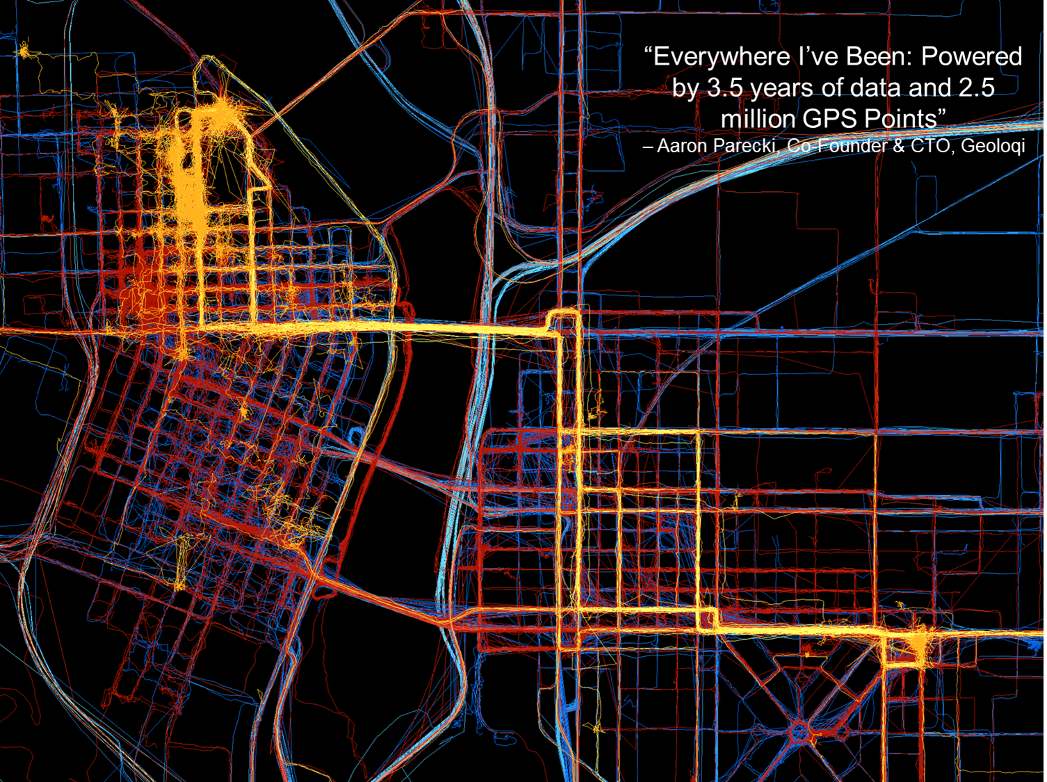
Here’s a young company, Geoloqi, doing really interesting things in Portland. They don’t have any clue where GPS came from; they just have it on their smartphones. One of the founders collected GPS data everywhere he went for the last three and a half years. This map shows 2.5 million data points, and I think it’s fascinating.
This map of Portland by Geoloqi has 2.5 million data points.
These folks interface between the GPS chipset in the mobile device and the apps that run on it. They sold their company to Esri last year.
“Geolocation has the potential to become an indispensable part of our lives. But to be a valuable service, the technology needs to be invisible yet opted into, private, and secure.” — Amber Case, Geoloqi founder
These kids just want to get things done, create ideas and create products: things like, check into a hotel when you get within 100 yards of the door; get your prescription prepared and ready for you when you come within a certain distance of a pharmacy. All these kinds of things are based on the geotrigger or geofence concept.
Now, talking about my work, primarily in surveying and mapping, with companies like utilities with 15 million customers and a lot of infrastructure. To put that at the fingertips of a maintenance person, that’s pretty amazing. I’ve been swimming in this soup for a long time, and I hadn’t heard of this concept — the predicted ephemeris (PRED) produced by GPSOC.
Take a PRED state vector data file, which is currently generated every 15 minutes by the GPS Operations Center under For Official Use Only (FOUO), currently designated unclassified, but not accessible to the general public. If it were made available for public use, it could decrease time to first fix from 40 seconds when you turn on your mobile device, to 5 to 10 seconds.
In the high-precision field like mine, surveying, it really doesn’t make too much difference because by the time you get out of your truck and set up your gear, 30 seconds has already gone by and it doesn’t make much difference.
Now it could be more of an issue with mobile devices in GPS-impaired environments such as urban canyons or indoor environments, where 30 seconds could make the difference between getting a fix or not.
If predicted ephemeris were available, developers could distribute it terrestrially via a wireless network to mobile devices.
Problem: How to transfer PRED from a U.S. government FOUO environment to make it available to application developers?
To me as a product developer or a product manager, interested in pushing products out to the community, that’s a really small speed bump. But when I talk to colleagues who operate in that (government) space, that’s a significant undertaking, a real obstacle. We’re talking about a big change, and a big process to go through to effect that change.
PRED from the horse’s mouth, so to speak, from the U.S. Air Force, really builds credibility. I can build it into a product, because I know it’s going to be there three or four or more years from now.
PRED can be made available, but Civil GPS app developers need to speak up — because civil users won’t. They don’t know about it. They don’t know what is possible.
“How does somebody know what they want if they haven’t even seen it?” — Steve Jobs
I’m trying to raise awareness here. I’ll probably write about soon in the magazine or in my [Survey Scene] email newsletter.
Frank van Diggelen, Broadcom. We’ve been doing this in the commercial world for over a decade. You all have it in your cellphones, with about 90% likelihood provided by Broadcom or someone who’s licensed our patents. It doesn’t work properly unless you have the source of the data and the client side working very cooperatively. The issue is the . . . gap between prediction and use. If the satellite is moved (in orbit or clock) then the prediction is wrong, and you need client-side software that is design cooperatively with the predictions. Our predictions are available in 2-, 4-, 7- or 30- day intervals. Think of a use case where you get a seven-day prediction, and then go away from network coverage for several days, meanwhile, say on Day 4, a satellite is moved or has its clock adjusted, on Day 5 it is set healthy, on Day 6 you turn on your handset and use the prediction from six days ago — it will be wrong and your client-side software has to catch that and know know how to invalidate the predictions.
We deliver these orbital predictions at about the rate of a billion per month. It’s been there for 10 years, and its been working so well most people aren’t even aware that it’s there. If the Air Force puts these out, that sounds great, but if you don’t have client-side software looking for erroneous predicitions — when a satellite is adjusted or moved — then things would be a lot worse for the user community than they have for the last 10 years.
Eric Gakstatter: I understand that, but that’s true for any technology. If a company implements it incorrectly, the market will reject it. Let the market decide.
There may be a need for a non-proprietary solution (PRED) that is publicly available so it could be implemented by other developers, and level the playing field to increase market adoption of GPS.
The TET-1 satellite has Septentrio on board. (Image: DLR)
Septentrio announced today that a PolaRx2 receiver has reached more than 330 hours of successful operation on board “Technologie-Erprobungs-Träger 1” (TET-1), the first satellite of the German On-Orbit-Verification program. The Septentrio receiver is the backbone of the Navigation and Occultation Experiment (NOX) developed by German Aerospace Center (DLR). The purpose of the experiment is to prove the suitability of commercial-off-the-shelf (COTS) technology for use in space missions.
The receiver provides GPS observations on the L1 and L2 frequencies, which are used for precise orbit determination and atmospheric sounding. The dual-frequency observations allow reconstructing the orbit of TET-1 with decimeter or better 3D accuracy. A dedicated antenna pointed into the anti-flight direction of the satellite is used to collect measurements during GPS radio occultations, where the signals are tracked through the Earth’s atmosphere.
After the first activation on July 26, 2012, the receiver has operated flawlessly in the harsh environment 500 km above the Earth’s surface and has been unaffected so far by space radiation. The receiver demonstrates quick acquisition of GPS signals and tracks a sufficient number of satellites even under challenging visibility conditions. The short time-to-first-fix together with the high availability of position and timing information from the navigation solution make the PolaRx2 a very suitable receiver for space-borne applications.
“We are proud to see a new illustration that our standard commercial receivers perform flawlessly even in the harshest circumstances,” said Peter Grognard, Septentrio’s founder and CEO. “Our customers benefit every day from the same high quality and robustness for their demanding industrial applications on earth ”
Update: Elon Musk, SpaceX’s CEO and chief designer, has posted an update on the status of the upcoming Falcon 9 launch on his Twitter account. “Will do another static fire of rocket to make sure all is good & AF [[Air Force]] needs to test ICBMs, so probable launch Sept 29/30,” Musk tweeted.
“The static fire is scheduled for later this week, perhaps Wednesday, sources said. It will retest the Falcon 9 rocket after several problems cropped up during a hotfire of the launcher’s engines Thursday at Vandenberg Air Force Base, Calif.
“The U.S. Air Force Western Range, which controls a network of tracking and communications assets based at Vandenberg, is busy for the next few weeks due to Minuteman ballistic missile testing.”
The Falcon 9 rocket, with CASSIOPE inside its fairing, on the way to the launch pad at Vandenberg Air Force Base. (Photo credit: SpaceX).
A GPS instrument designed by University of New Brunswick scientists is scheduled to be launched into space aboard the SpaceX Falcon 9 rocket on September 15. The rocket will depart Vandenberg Air Force base in California as part of the CASSIOPE (Cascade Smallsat and Ionospheric Polar Explorer) mission.
Dr. Richard Langley, GPS World Innovation editor and professor in geodesy and geomatics engineering at the University of New Brunswick, is a principal investigator behind the scientific portion of the CASSIOPE mission. Langley and his colleagues will monitor data from the GPS instrument, which is part of the Enhanced Polar Outflow Probe (e-POP) payload aboard the spacecraft.
E-POP will continue the sequence of Canada’s orbiting space environment sensors, which began with Canada’s first satellite, Alouette 1, launched in 1962 to study the ionosphere. e-POP is, perhaps, the most extensive suite of sensors for studying the ionosphere/magnetosphere/thermosphere yet to be launched, and will provide Canadian and other scientists with the opportunity to better understand the impact and variability the sun has on the space environment — what we call “space weather.”
The research satellite CASSIOPE on a test platform at the Canadian Space Agency’s David Florida Laboratory. CASSIOPE hosts the GPS Attitude, Positioning, and Profiling instrument designed by GGE researchers. The four white antennas on the left-facing side of the spacecraft will be used to determine the position, velocity, and attitude of the spacecraft while the antenna on the upper side will be used to profile the ionosphere’s electron density. (Photograph courtesy of MacDonald, Dettwiler and Associates Ltd.)
Answer a GNSS Trivia Question and Get in on the Musical Action
Got the urge to sling notes likes a Nashville country star? Come by GPS World’s booth (#116–#118) at ION GNSS+ for a look at the brand-new Fender Telecaster electric guitar — first prize in a random drawing of correct answers in a GNSS Trivia Contest.
One lucky winner will leave ION with this music legend under his or her arm. All you have to do is correctly answer One Question, such as:
What does DRMS stand for, in the GNSS community?
A. Data Record Management System
B. Decision, Risk, and Management Sciences
C. Defense Resource Management System
D. Distance Root Mean Square
Correct answers will go in one bin, incorrect answers in another. At 3:45 p.m. Thursday in the GPS World booth, during the afternoon coffee break on the exhibit floor, one winner will be drawn at random from each bin. The winner from the first bin gets the Telecaster guitar; the winner from the second bin gets two tickets to GPS World’s Leadership Dinner on Thursday evening.
All players must complete a subscription form to qualify for a free subscription to GPS World magazine, or one of eight different email newsletters, in order to play the Trivia Game.
Winners need not be present at the drawing to win — but must respond to an email or text alert, to come by the booth before 6 p.m. on Thursday to claim either prize.
The Telecaster, a dual-pickup, solid-body electric guitar made by Fender, revolutionized sound when it burst upon the scene in 1951, and has been in continuous production ever since. Guitarists from Jeff Beck to James Burton, not neglecting Keith Richards or Bruce Springsteen, have played on a Telecaster.
Despite the continued decline of PNDs, and the threat of smartphones, smart watches and eyewear, the portable GPS-enabled device market is forecast to continue to hold its own thanks to dedicated HUD/eyewear, cycling and health/tracking devices, according to a report by ABI Research.
ABI Research’s quarterly GNSS Database forecasts the new and emerging markets for GPS-enabled devices, and where the opportunities lie in terms of device formats and vertical markets. The report also considers the impact of competitive formats such as smartphone applications, wearable sensors, smart watches, and smart eyewear, providing a complete picture of drivers and inhibitors in this market.
Senior analyst Patrick Connolly comments, “The overall market is forecast to grow from 33.3 million units in 2012 to 36.79 million in 2018, following a brief dip in 2013 as PND declines outweigh growth in other areas. Total revenues will undergo a brief period of fluctuation from 2013 to 2015, before rising to $7.14 billion in 2018.”
Dominique Bonte adds, “The markets for cycling computers, health/elderly, and fitness are starting to get interesting. As ASPs decline and smart watches become a more established part of our lives, the addressable market will be eaten up, limiting the growth potential for dedicated fitness devices. Looking longer term, ABI Research has forecast very strong growth for HUD/eyewear devices, particularly in the fitness, golf, and cycling categories. It would not be surprising to see an acquisition in this space over the next 12 months.”
These findings are part of ABI Research’s Location Devices Research Service, which includes research analyses, market data, insights, and competitive assessments focused on the GPS/GNSS IC and devices markets.
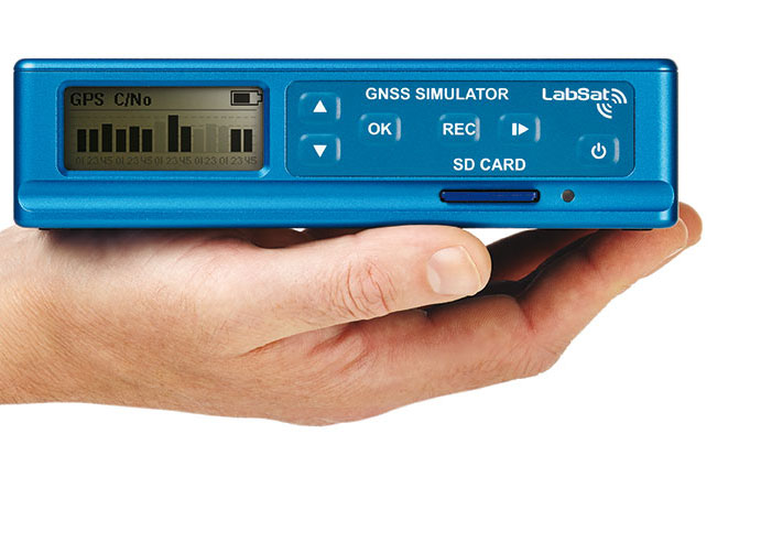
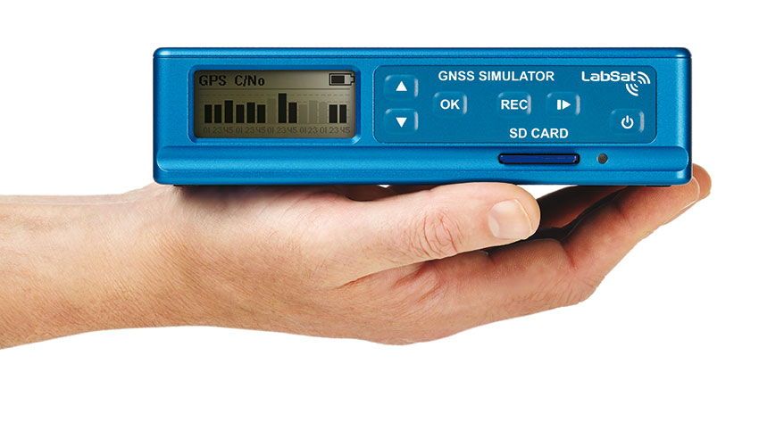
LabSat, the GPS record, replay, and simulation brand produced by Racelogic in the UK, is about to be augmented with the introduction of LabSat3.
The key feature of the new product is its simplicity. It is, essentially, a single-box device that incorporates a GPS record-and-replay system without the need for a laptop or PC. Racelogic has designed the LabSat3 with convenience at its core: it is small and light, allowing users to record GPS signals in any situation, the company said. It will also come with a pre-recorded library of worldwide scenarios to allow engineers to perform immediate bench testing.
The new LabSat is able to record signals from GPS, GLONASS, Galileo, BeiDou, QZSS, and SBAS, with the top of the range models able to output two channels simultaneously. Both the recording and replay procedures are simple one-touch operations, with data being logged to an SD card.
LabSat3 is compatible with scenarios generated with SatGen software for those that wish to create full simulations. Ethernet connectivity extends its potential to end-of-line testing where multiple units can be remotely controlled, with potentially large savings in production line testing times.
LabSat3 is set to be launched at the ION GNSS+ exhibition in Nashville next week. Prices will start at $4,400. For further details, visit the LabSat website.