Category: Uncategorized

  • CYAN EC software-defined radio performs multiplexing for system integrators

    CYAN EC software-defined radio performs multiplexing for system integrators

    Photo: Per Vices
    Photo: Per Vices

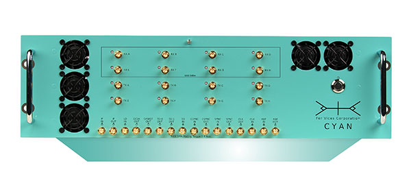
    Per Vices Corp. has launched an upgraded version of its high-performance software-defined radio (SDR) platform Cyan EC (extended channel).

    Cyan EC enables up to 64 digital signal processing (DSP) channels across 16 physical SMA ports. This extension allows Cyan EC users to break up the one large bandwidth physical chain into multiple digital channels, allowing the radio platform to do the multiplexing.

    By providing additional digital chains, which are coherently superimposed into a single physical channel, the computational complexity required to address wide bandwidths is further reduced, and allows for processing over multiple cores on a single host system or across multiple host systems concurrently.

    “We are excited that customers have already used and integrated our platform into their products,” said Victor Wollesen, CEO of Per Vices Corp “The additional processing capability provided by this option allows our customers to improve performance and implement more advanced applications using existing computational resources. I believe Cyan EC is the highest channel count software-defined radio commercially available.”

    The Cyan EC product option enables engineers and system integrators to realize the benefits of both the high-bandwidth SDR and having more independent channels to ease the complexity associated with processing the high amount of data by breaking it up into separate channels. This further helps to achieve better spurious-free dynamic range (SFDR), sensitivity and signal-to-noise ratio (SNR) while continuing to offer a high throughput SDR solution.

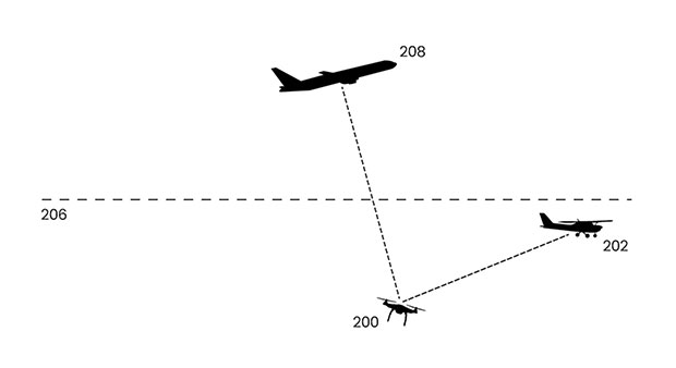
    Cyan EC benefits engineers and integrators across different markets including GNSS/GPS, radar systems, magnetic resonance imaging (MRI) receivers and exciters, and spectrum monitoring, as well as test and measurement.

    A Top Canadian Defense Company

    Image: Canadian Defence Review
    Image: Canadian Defence Review

    Per Vices Corp. has been named one of the Top Defence Companies in Canada for 2021 by Canadian Defence Review, a defense and military magazine. A new inclusion to the list for 2021, Per Vices specializes in software-defined radio (SDR) solutions that are integrated into radar, GNSS/GPS, satellite, aerospace and communications systems.

    The company is growing and expanding its operations and product line to satisfy the stringent and advanced requirements of its clients and their applications.

    “We are incredibly honoured to be added to this list,” said Brandon Malatest, COO, Per Vices Corp. “This shows recognition and support for high performance manufacturers and companies that are bringing innovative solutions to the table, both within Canada and internationally. We offer the best software defined radio solutions commercially available and work closely with our customers to solve challenges for mission critical applications.”

    The 100 companies, which must have manufacturing, R&D or service operations in Canada, are evaluated by Canadian Defence Review editorial staff and independent advisors. They are ranked on factors such as economic impact to the country, research and development initiatives, innovation, contribution to the nation’s security, and contract wins. The list is used to showcase Canadian technological innovation and its defence industry.

  • Seen & Heard: Drones buzz warships, Beirut explosion effects

    Seen & Heard: Drones buzz warships, Beirut explosion effects

    “Seen & Heard” is a monthly feature of GPS World magazine, traveling the world to capture interesting and unusual news stories involving the GNSS/PNT industry.


    Photo: U.S. Navy
    Photo: U.S. Navy

    Drones buzz warships

    Several drones swarmed Navy destroyers off the California coast in July 2019, and it remains unclear who was behind the nighttime flights, according to a report on the website The Drive, quoting ship logs. As many as six drones flew around the warships at a time in often low-visibility conditions over a number of days, with the drones flashing lights and prompting security precautions onboard. The drone flights took place near San Clemente Island, home to sensitive military facilities: a Navy SEAL training site, the Navy’s ship-to-shore live firing range and an airfield. The drone flights prompted inquiries from investigators and intelligence officers in the Navy and the FBI, and are receiving high-level attention.


    Blast shakes ionosphere

    A 2020 explosion in Beirut, Lebanon, caused a southward-bound, high-velocity atmospheric wave that rivaled ones generated by volcanic eruptions, according to researchers at Hokkaido University in Japan. On Aug. 4, 2020, more than 2,750 tons of unsafely stored ammonium nitrate exploded, killing 200 people and leaving a 140-meter-diameter crater in its wake. To estimate variation in total electron content, the researchers collected RINEX GNSS data from 15 CORS stations in Israel and Palestine. The ionospheric disturbance was detected by differential delays of microwave signals of two carrier frequencies from GNSS satellites. The blast is considered one of the most powerful non-nuclear, manmade explosions in human history. Their findings are published in the Feb. 2, 2021, issue of Scientific Reports.


    Screenshot: BBC video
    Screenshot: BBC video

    3D modeling aids investigation

    Amnesty International used 3D modeling, satellite imagery and geotagged video to reveal a suspected war crime in Ethiopia’s civil war, according to the BBC and CNN. With a communications blackout in place, activists and journalists turned to mapping technology and satellite imagery to determine the location of a video provided by a whistleblower within the Ethiopian Army. A forensic frame-by-frame analysis of the footage revealed the extra-judicial execution of at least 15 young men taken from a village in Tigray by Ethiopian Army soldiers in early March.


    Photo: Murata Manufacturing
    Photo: Murata Manufacturing

    Traffic counts

    In April, Murata Manufacturing began providing data from a traffic counter system that maps traffic volume with lidar technology. Murata uses lidar instead of cameras, because the technology can adapt to changing conditions, including rain and darkness. Data collected also classifies vehicle types, enabling strategic advertising and use as reference data for city planning, such as for the construction of shopping malls in locations with significant traffic levels. The service is expected to expand to Thailand and Malaysia.

  • uAvionix adds ping200XR with integrated GPS to transponder lineup

    uAvionix adds ping200XR with integrated GPS to transponder lineup

    Photo: uAvionix
    Photo: uAvionix

    uAvionix has added a new low-SWaP transponder to its line-up of unmanned aerial system (UAS) communications, navigation and surveillance solutions.

    The ping200XR integrates the capability of the ping200X TSO Certified Mode S ADS-B OUT transponder with the high-integrity truFYX TSO-certified GPS position source into a single enclosure. The single enclosure simplifies installation and allows the customer to choose between the existing installed GPS antenna or one provided with the ping200XR.

    The integrated GPS ensures maximum safety by providing Source Integrity Level (SIL) 3 RTCA DO-229D and TSO-C145e Class Beta 1 performance, a requirement for Mode S and ADS-B airspace access, and for reception and processing by certified avionics and Traffic Collision Avoidance Systems (TCAS) in other aircraft, as well as Air Traffic Control (ATC). SIL 3 performance is not available from non-aviation certified GPS, which are often used as an autopilot navigation source.

    The ping200XR can be integrated with popular onboard UAS autopilots for dynamic control from ground-control stations, including George — uAvionix’s enterprise autopilot solution. The ping200XR can also be pre-configured before flight and carried as a payload.

    Replicating the functionality of a cockpit transponder controller, the uAvionix mini-controller allows users to dial-in a squawk code before takeoff for even quicker integration and rapid deployment.

  • Thank you for registering.

    Thank you for registering for the upcoming webinar, “It’s About Time: PNT Challenges and Benefits of Multi-Constellation and Multi-Signal GNSS” sponsored by Tallysman.

    A link to the live event will be sent to you two hours before the event. Your personalized event URL will be automatically generated by the ON24 system. To ensure receipt of the email, please whitelist this email address by adding it to your contacts: [email protected].

    This presentation will begin at 1 p.m. Eastern / 10 a.m. Pacific / 7 p.m. Central European Time on Thursday, May 27th.  A recording will also be sent to you the following day so you can watch it on-demand.

    Audience members may arrive 15 minutes prior to live time. If you have any questions, please contact event producer Mackenzie Schoenherr at [email protected]

  • uAvionix launches enterprise UAS autopilot dubbed ‘George’

    uAvionix launches enterprise UAS autopilot dubbed ‘George’

    Photo: uAvionix
    Photo: uAvionix

    uAvionix Corp has launched its first autopilot for unmanned aircraft systems (UAS), named George.

    At 80 grams, George is a low size, weight and power (SWaP) certifiable solution for enterprise operations and those wishing to type certify their UAS. It is manufactured in the United States.

    Built around the open-source autopilot Cube from CubePilot, George combines Cube with Design Assurance Level C (DAL-C) hardware and safety and sensor monitoring, enabling customers to meet the type certification and safety case requirements for beyond visual line of sight (BVLOS) operations.

    George’s triple-redundant inertial measurement unit (IMU) system includes three accelerometers, three gyroscopes, three magnetometers and three barometers, one of which has been TSO-certified under TSO-C88b in other uAvionix products such as skyBeacon, tailBeacon  and ping200X. The hardware platform is designed and built to RTCA DO-254 DAL-C and meets rigorous DO-160G and MIL-810H power and environmental qualifications.

    George is plug-and-play compatible with all of uAvionix’s certified and uncertified products, including

    • truFYX GPS (TSO-C145e)
    • ping200X (TSO-C112e, TSO-C166b, TSO-C88b)
    • RT-2087/ZPX-B (AIMS MkIIB)
    • pingRX Pro dual-band ADS-B receiver for detect and avoid
    • the microLink or SkyLink C-band command and control solutions

    “The flight control capabilities of the Cube are superb, backed by hundreds of thousands of man-hours of engineering and experimentation over the past 10 years,” said Paul Beard, CEO of uAvionix. “But what has been lacking is a hardware platform that matches that capability in robust performance. George brings everything we’ve learned about certified avionics to the autopilot space in a way that outperforms existing enterprise and military autopilots in a lower SWaP package.”

    George will be available for beta test-launch customers in June with production units available in the third quarter.

  • uAvionix receives patent for drones to use ADS-B safety benefits

    uAvionix receives patent for drones to use ADS-B safety benefits

    Image: uAvionix
    Image: uAvionix

    uAvionix has been granted a patent that aids safe and secure integration of unmanned aircraft systems (UAS) into the National Airspace System (NAS).

    U.S. Patent 10,991,260, “Intelligent Non-Disruptive ADS-B Integration for Unmanned Aircraft Systems (UAS),” provides the ability for UAS to take advantage of the safety benefits of Automatic Dependent Surveillance-Broadcasts (ADS-B) while minimizing spectrum use.

    uAvionix first revealed this concept in a 2018 white paper titled “ADS-B Inert and Alert – A Solution to the ADS-B Spectrum Concerns.” The Inert and Alert Concept preserves spectrum by allowing the onboard UAS ADS-B solution to remain inert in a non-broadcasting listening mode until a safety-critical event such as a C2 lost-link or other aircraft proximity triggers it to begin broadcasting its ADS-B position as an alert. Once the conditions are safe again, the system reverts to its inert state.

    “uAvionix is a firm believer in the benefits of a cooperative airspace for UAS integration,” said Christian Ramsey, president of uAvionix. “Recognizing the concerns by regulators of over-use of the spectrum, Inert and Alert is a means to leverage ADS-B for collision avoidance while significantly reducing those concerns.”

  • NavVis IVION Core reality-capture platform adds value to buildings, assets

    NavVis IVION Core reality-capture platform adds value to buildings, assets

    Photo: NavVis
    Photo: NavVis

    NavVis has launched NavVis IVION Core, a reality capture platform for management of 3D scans with intuitive tools for creation, collaboration and publication. Previously known as NavVis IndoorViewer, NavVis IVION Core makes mobile mapping workflows more efficient, speeds up model creation and delivery, and adds value to data, the company said.

    “NavVis IVION Core represents the future of reality capture software,” said Lisa Cali, head of Product Web and Cloud at NavVis. “We want to offer our users a next-generation platform that not only transforms their mobile mapping workflows but also extends them so that they can do more with their spatial data.”

    With all the existing features of NavVis IndoorViewer, such as point cloud downloads and virtual measurements, NavVis IVION Core offers a refreshed look and new features and improvements.

    Enhancements are expressly designed to support laser scanning service providers, surveyors and AEC companies. These include multi-site functionality, updated user management, and site coordinate systems for survey-grade geo-registration of data.

    Multiple sites, one space. The multi-site functionality means users are able to host multiple sites, including several buildings, in one instance. The new home screen displays a map view with markers showing the location of each site. It’s easy to navigate and provides the user with a clear overview of each site or project across the globe, with quick switching between sites from the central dashboard. Each site has a unique website address and user permissions, providing complete control over site usage.

    Updated user management system. This improvement gives users more clarity and control over their projects. Admins can grant specific access and permissions for each site and get an overview of the permissions of each user. From an editor to a visitor, accessibility and permissions can now be set easily and viewed clearly from one instance.

    Site coordinate system. Users can now enter the latitude and longitude or a custom spatial reference system, allowing for survey-grade geo-registration of data. Selecting a site coordinate system also ensures that data is aligned to the exact location of a site, making it easier and faster to upload and download data.

  • Honeywell launches ultra-rugged IMUs for commercial, defense use

    Honeywell launches ultra-rugged IMUs for commercial, defense use

    As illustrated here, the new HG1126 IMU is about the size of a water-bottle cap. (Photo: Honeywell)
    As illustrated here, the new HG1125 IMU is about the size of a water-bottle cap. (Photo: Honeywell)

    Honeywell has launched a new series of miniature inertial measurement units (IMUs) ruggedized to offer high accuracy along with the durability to survive high-shock environments.

    Roughly the size of a water-bottle cap, the new HG1125 and HG1126 IMUs are low cost and serve both commercial and military applications.

    The new family of IMUs can survive shocks up to 40,000 G-force, making it one of Honeywell’s toughest IMU products to date. The HG1125 and HG1126 can be used for a variety of defense and commercial applications such as tactical military needs, drilling, unmanned aerial vehicles or navigation systems for general aviation aircraft.

    “Low-cost, ultra-rugged IMUs are in high demand across a variety of market segments where customers need high-performance navigation, but they’re limited by size or cost constraints,” said Matt Picchetti, vice president and general manager, Navigation & Sensors, Honeywell Aerospace. “Our new HG1125 and HG1126 products meet all of these requirements, making them an ideal solution for customers operating in a wide variety of high-shock environments, including everything from military tactical operations to industrial applications such as drilling.”

    An IMU uses gyroscopes, accelerometers and electronics to give precise rotation and acceleration data. This enables a vehicle system to calculate where it is, in what direction it is going, and at what speed, even when GPS signals are not available.

    The HG1125 and HG1126 use sensors based on micro-electromechanical systems (MEMS) technology to precisely measure motion. They are the newest IMUs from Honeywell’s tactical IMU production facility, which delivers nearly 100,000 IMUs each year to customers across a wide range of segments.

    The first deliveries of these new products are set to begin in June.

    Honeywell’s lineage in navigation dates to the 1920s, and it has long been a pioneer in MEMS-based IMUs. Honeywell has developed and manufactured high-performance navigation solutions found on many aircraft and other vehicles worldwide.

  • Long-flight UAV debuts at Zala Expo in Moscow

    Long-flight UAV debuts at Zala Expo in Moscow

    Zala Aero Group unveiled a new unmanned system for long-distance flights — the Zala 421-16E5G — at the closed exhibition Zala Expo,  which began on April 19 in Moscow.

    The Zala 421-16E5G is a domestic unmanned aerial vehicle with a hybrid power plant. The non-aerodrome-based system is capable of providing aerial monitoring over distances of more than 150 kilometers and staying in the air for more than 12 hours.

    The Zala 421-16E5G has a unique power plant that charges a buffer battery for an hour. The power plant allows the UAV to fly long distances. During production test flights, the Zala 421-16E5G flew 16 hours.

    The unmanned system is equipped with a combined payload with two thermal imagers and a 60x video camera. Optionally, the Zala 421-16E5G is capable of carrying a payload weighing up to 10 kg. The video stream is broadcast in high-definition format (1280 x 720 resolution), which allows the ground-station operator to view the streaming image in great detail.

    In addition to optoelectronic loads, the device is equipped with electronic reconnaissance equipment and communication repeaters. Objects are detected and recognized in real time by the onboard computer based on artificial intelligence.

  • Septentrio launches AsteRx-i3, its next-gen GNSS/INS product line

    Septentrio launches AsteRx-i3, its next-gen GNSS/INS product line

    By expanding its GNSS/INS product family, Septentrio starts offering more application-specific positioning and orientation solutions

    Septentrio, a leader in high-precision GNSS positioning solutions, has launched the AsteRx-i3 — a new product line of high-performance GNSS plus inertial navigation system (INS) receivers.

    The AsteRx-i3 product family brings to market an array of next-generation receivers from plug-and-play navigation solutions to feature-rich receivers with raw measurement access. OEM boards are available for rapid integration as well as ruggedized receivers enclosed in a waterproof IP68 housing.

    The variety of products in the AsteRx-i3 line accommodates the specific needs of applications that require high-accuracy positioning together with 3D orientation, heading, pitch and roll angles.

    The AsteRx-i3 Pro+ in a rugged housing. (Photo: Septentrio)
    The AsteRx-i3 Pro+ in a rugged housing. (Photo: Septentrio)

    “Using our off-the-shelf GNSS/INS systems allows our customers to focus their efforts on core technology and to reduce their products’ time-to-market,” said Danilo Sabbatini, product manager at Septentrio. “With this new generation of products, we aim to satisfy specific needs of various customers. Instead of releasing a single general-purpose product, we bring several dedicated solutions for fastest and easiest integration into systems that require robotic navigation or sensor fusion.”

    AsteRx-i3 Pro+ receivers support either single- or dual-antenna modes. The single-antenna mode is suitable for compact and light-weight configurations. The dual-antenna mode reduces the need for movement during IMU initialization, allowing fully informed navigation from mission start.

    The AsteRx-i3 product line includes five new GNSS/INS receivers.

    • The Pro receivers offer high accuracy positioning with 3D orientation and dead-reckoning functionality for fastest and easiest plug-and-play integrations.
    • The Pro+ are the most versatile receivers providing integrated positioning and orientation along with raw measurements, in single- or dual-antenna configurations, suitable for applications with sensor fusion. One of the receivers offers an off-board inertial measurement unit (IMU), which can be mounted exactly at the alignment point of interest.

    For more information about the new AsteRx-i3 product line visit Septentrio.com/products or contact Septentrio.

    Photo: Septentrio
    Photo: Septentrio
  • Thank you for registering.

    Thank you for registering for the upcoming webinar, “Resilient PNT for a 5G World” sponsored by Orolia.

    A link to the live event will be sent to you two hours before the event. Your personalized event URL will be automatically generated by the ON24 system. To ensure receipt of the email, please whitelist this email address by adding it to your contacts: [email protected].

    This presentation will begin at 1 p.m. Eastern / 10 a.m. Pacific / 7 p.m. Central European Time on Thursday, May 20th.  A recording will also be sent to you the following day so you can watch it on-demand.

    Audience members may arrive 15 minutes prior to live time. If you have any questions, please contact event producer Grace Rybak at [email protected]

  • NCM hires Luccio as GPS World Editor-in-Chief

    NCM hires Luccio as GPS World Editor-in-Chief

    Headshot: Matteo Luccio
    Matteo Luccio

    North Coast Media (NCM) has hired Matteo Luccio as editor-in-chief of GPS World, the industry’s most-trusted resource since 1990. Luccio possesses more than 20 years of experience as a writer and editor for various geospatial, GNSS and positioning, navigation and timing (PNT) media.

    “I am thrilled to help guide the editorial team of GPS World, the undisputed GNSS/PNT media leader,” said Editor-in-Chief Matteo Luccio. “Our content will continue to be driven by our unparalleled audited audience of 54,000-plus engineers designing solutions to today’s most-pressing GNSS/PNT challenges.”

    Luccio began his current career in 2000, serving as managing editor of GPS World and Galileo’s World. After that, he served as editor and publisher of GPS User, and editor of Earth Observation Magazine and GIS Monitor. He has served as a columnist for Professional Surveyor, a contributing writer for Apogeo Spatial and xyHt, and a special correspondent for Sensors and Systems. He also has written for ArcNews, ArcWatch, GeoWorld, GIM International, and GEO Informatics.

    The past several years, Matteo has served as a GPS World contributing editor, reporting on new technologies and applications for GNSS receivers, antennas, simulators, and alternative PNT solutions. Luccio holds a master’s degree from the Massachusetts Institute of Technology (MIT).

    Luccio will work closely with Marty Whitford, Editorial Director and Publisher; Tracy Cozzens, Senior Editor; Diane Sofranec, Staff Editor; Wes Temple, Digital Media Editor; and Charles Park, Art Director.

    “Matteo has come full circle, returning full time to GPS World, where he began his stellar GNSS/PNT career,” Whitford said. “We’re excited to have Matteo share GPS World’s edit helm, helping our readers and marketing partners position for maximum growth for years to come.”