U-blox is partnering with ArduSimple, a Spanish company seeking to facilitate the adoption of centimeter-level GNSS technology for mass-market applications.
The companies partnered to develop the SimpleRTK2B single-board computer (SBC). The device, which is built around up to three u-blox ZED-F9P high-precision GNSS receivers, simplifies the development of centimeter-level positioning solutions supporting real-time kinematics (RTK), making the technology accessible to broader audiences.
The SimpleRTK2B-SBC was developed to make RTK technology as close to plug-and-play as possible. In addition to working as a stand-alone solution, customers can program their own applications with the company’s microPython API.
The SimpleRTK2B-SBC delivers mechanical integration with centimeter position on three axes (heading, pitch and roll), outputting on NMEA, RTCM, RS232 and CANBus interfaces via Ethernet, Bluetooth, Wi-Fi and 2G/3G/4G communication. It offers configurable input/output and an inertial measurement unit.
The physical and digital world are integrating. We are nearing the edge of the analog universe. Physical immersion is giving way to virtual immersion. It is the virtualization of products and services in the evolution of technology. Michael Saylor calls it the sixth wave of software engineering. We are moving away from externally experiencing data and are moving towards actively interfacing with data directly in virtual space.
“You can Zoom anywhere at the speed of light and bend time and space.” — Michael Saylor
The world of tomorrow is already here. We are waking up to it. The blips of information at the fringes are coming nearer. The horizons of time are as far as one can see into the future and the past. How far can you see? From wherever you are there are others who can see a little further. Look forward. Look back. Others are ahead and behind. They exist where time is most comfortable for them. Some take up positions living in the past. Some stake their place as far into the future as they are able. Look towards those early adopters. Ask them what they think. They see more clearly the blips of information out on the horizon.
What are those blips? How will they impact the geospatial community? How can you position yourself to take advantage of the coming trends?
America needs to go back to work and America’s infrastructure is old and in disrepair. In 2019, Congress introduced H.R.4687, the SMART Infrastructure Act, a $2 trillion bill but it never made it out of the House. However, that bill is being reintroduced. This time it will become a bill putting America back to work and its price tag will likely eclipse the previous bill. It will address infrastructure — all types of infrastructure: physical, data, cybersecurity, health, financial, transportation, energy, and communications. It will be a primary theme for the next two decades. Get ready! Change can happen fast and it’s about to accelerate.
“The future happens slowly and then all at once.” — Kevin Kelly
Rebuilding this infrastructure will require geospatial technologies. STEM has been the siren call for the past 30 years and for good reason. Those who heeded the call and invested their education into coding, engineering, data science, geospatial technologies, mathematics, artificial intelligence, and other STEM related fields are going to lead the coming workforce. Now is the time to get certified and establish your credentials.
Take the case of architectural design and construction. It used to be blueprints drawn on light tables. That is how I learned to do it back in the 1970s. Then it all moved to computer aided design (CAD) drawings. Now, urban planners and architects create immersive 3D virtual reality (VR) visualizations. That is becoming standard practice.
Project managers used to spend their day making their rounds walking the site ensuring the project was being built to specifications. However, that is changing. Soon, each worker’s safety glasses will have built-in augmented reality (AR). They will build their portion of a project exactly to plan. Project managers will connect with workers in the field and see the project they are working on progress in real-time while in their office on 3D models.
When the project manager does walk the site he or she will be wearing augmented reality (AR) head-up displays and able to compare the physical construction to the digital model in real-time. Backhoe and excavator operators will grade to exact precision. Robots will be common at construction sites assisting operations and enhancing current capabilities. Unmanned aerial vehicles (UAV) will fly regular patterns over construction sites. Heavy-lift UAVs will supplement cranes for some operations. Subsurface structures, whether buried beneath the ground or behind a wall will be digitized with precise location data making future replacements and repairs swift and easy. The uses of geospatially dependent technologies will continue to grow. The construction worker of tomorrow will be very different than the one of today.
Photo: Trimble
The new infrastructure will be built with smart technologies and incorporate renewables and “green energy” initiatives with a responsible approach to sustainability; for example, roadways will have embedded peizo-electric crystals in the asphalt to generate electricity from passing vehicles. The electricity will charge batteries that will power smart sensors embedded in the street and provide power to street lights with sensors and 5G networks along the roadways. Excess power will transfer to other microgrids for use elsewhere. Energy will also come from capturing wind on top and along the sides of buildings, along roadways, and at tunnel exits and entrances. Thermocouples will capture heat and generate electricity.
Solar power will be generated from panels, windows, films, and even paint surfaces. All of these sources together will feed into microgrids. Some of this renewable energy will convert water to hydrogen for fuel cells, and some will power carbon dioxide (CO2) converters to extract CO2 from the atmosphere and create synthetic fuels. In 2010, Sunexus submitted a geospatial study of the solar reforming process to the Office of Scientific & Technical Information (OSTI). The study showed that nearly 58% of industrial CO2 waste from power plants, cement plants, ethanol production, and natural gas processing could be converted to synthetic diesel fuel.
Image: U.S. Office of Energy Efficiency and Renewable Energy
Besides energy, other smart materials will be used such as small sensors that are geospatially sensitive nanodevices embedded in roads, bridges, tunnels, buildings and other structures. They are wirelessly connected to one another creating a 3D mesh network. These nanodevices continuously report their structural health. This 3D mesh network can detect vibrations passing through it that cause distortions in the mesh framework.
Geospatial artificial intelligence (GeoAI) will profile devices based on their normal statistical ranges. If any data such as location, temperature, humidity, pressure, acoustics or health status exceed the device’s standard deviation the GeoAI will analyze surrounding nodes in the mesh network to depict patterns. Suspect events will immediately come to the attention of emergency services. These microdevices can provide early detection of cracks in a structure or deterioration of a surface protection layer.
The use of these devices extends beyond structural monitoring. More broadly, they have societal applications too, such as for security purposes. When fitted with acoustic sensors they can detect sounds, and by geospatially analyzing the data from many thousands of devices the epic center of a noise event can immediately be located. Take for example a gun shot, fireworks, an explosion, or a vehicle accident. The increased acoustic signal would trigger the GeoAI monitoring the devices to plot a spatial analysis of the acoustic report. The map would alert area would flash red on the monitor at the control center and nearby cameras would zoom in on the location providing images and live video feeds all within moments of the triggering event. The analysts at the control center could immediately assess the situation and dispatch the proper response units.
Embedded devices also serve as seismic sensors blanketing broad areas and are able to record surface vibrations moving through the mesh network. An earthquake would appear as a moving wave field along the network.
Additionally, data from the mesh network can integrate with other devices. It can provide smartphones with precise location data. Imagine no longer standing on a street corner turning in circles trying to figure out which way to go. When connected with the mesh network and looking through AR glasses or the smartphone view screen the path will be illuminated. Autonomous vehicles will connect with the mesh network and have absolute positional accuracy and have awareness of other vehicles, bikes, and pedestrians ensuring a more safe and efficient experience for everyone.
The mesh network can be used as a base layer for georeferencing the world. Notifications, warnings and requests for information can be sent to smartphones within an exact georeferenced location. Imagine being in your third-floor apartment sitting in your chair, listening to music on your headphones and reading an ebook. You are oblivious to the noise outside. An audible alert is sent to your phone and calls your attention. You look at your phone and a message is requesting information related to a possible gunshot at DD°MM’SS.sss N, DD°MM’SS.sss W. You click on the notification and a map opens up. You see it is right outside your window. You go to the window, look outside and see two people duck into a car. You watch as red tail lights drive away. You look back at the location on the street where the vehicle had been and a person is slumped over leaning against a stairwell.
On your phone you press the red alert button on the map application triggering a distress signal and confirming the incident may have been a gunshot and someone has possibly been injured. Emergency services immediately dispatch. Others nearby received the same alert message because it was automatically generated and sent out to all phone numbers within the area defined by the geospatial acoustic solution. Surveillance cameras on the corner of buildings were also triggered by the alert and automatically focused on the origin of the noise. Images of the assailants were captured along with the license plate of the vehicle. As the vehicle drove away a network of surveillance cameras continued following it turn by turn until it was finally intercepted and the occupants apprehended.
This world is nearer than it seems. The technologies are already here. Once the infrastructure bill is passed construction projects will begin and our physical world will begin to integrate with the digital world. The engineers design it. The construction workers and robots will build it. And it will be geospatial technologies holding it all together.
William Tewelow works for the Federal Aviation Administration. He is a graduate of the FAA management fellowship program. He served on special assignment to the U.S. Department of Transportation leading a national strategic geospatial initiative for the White House Open Data Partnership. He is a Geographic Information Systems Professional (GISP) and a speaker for the Maryland STEMnet Scholar program. He was among the first in the nation to earn a Geospatial Specialist Certification from the U.S. Department of Labor while working at NASA Stennis Space Center. He has degrees in Geographic Information Technology, Intelligence Studies, and is completing a masters degree in Organizational Management. William is a 23 year veteran for the U.S. Navy serving as a Geospatial Specialist, Imagery Intelligence Specialist, a Naval Aviator, a Meteorologist, and a Tactical Oceanographer. He is married, enjoys writing and traveling. His favorite quote is, “A man’s mind changed by a new idea can never go back to its original dimension.” — Oliver Wendell Holmes
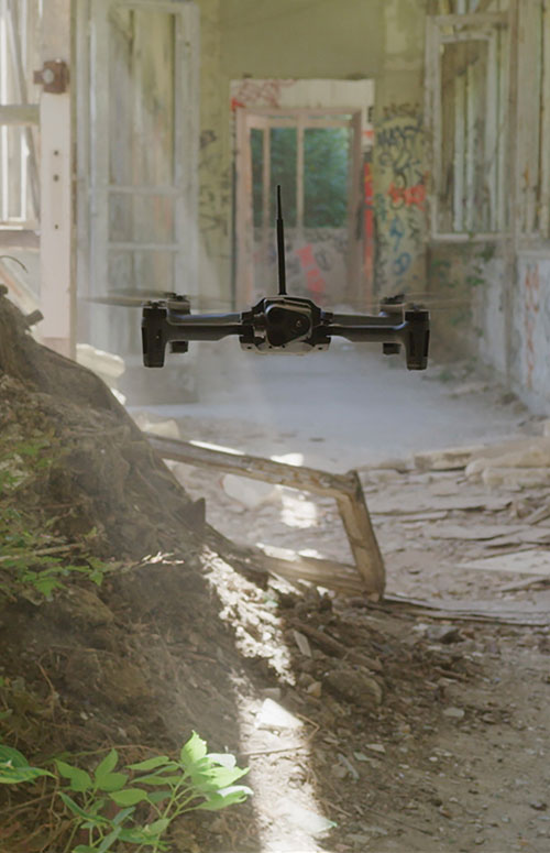
Every ounce counts on a drone. While a larger ground plane on a GNSS patch antenna improves its performance, the additional size increases weight — an unacceptable tradeoff.
The antenna’s location on the drone is another factor. It must be distant from motors and other electronic components that generate interference, which undermines positional accuracy. But remote locations are often off-limits because the antenna’s weight in those spots would disrupt the delicate balance drones require.
Drone-maker Parrot took these factors into consideration when choosing a GNSS antenna for its ANAFI USA drone. Although it weighs just 500 grams, ANAFI USA is designed to operate in winds up to 53 km/h.
To meet these challenges, Parrot chose the Taoglas DSGP.1575.15.4.A.02, a passive patch antenna that supports GPS L1 and Galileo E1. At 3.3 grams and 4 mm high, with a 15-mm2 footprint, the DSGP.1575 is designed for ultra-compact devices.
Key customers
High GNSS accuracy and reliability are critical for Parrot customers such as the French military, which recently ordered 300 ANAFI USA drones for reconnaissance and intelligence missions by its conventional and special forces.
Manufactured in the United States, ANAFI USA has also been selected by U.S. federal government partner organizations as part of the Blue sUAS project — the only UAV from a non-American drone manufacturer to be commercialized on the GSA Schedule, the buying platform of the U.S. military and civilian government agencies.
Police departments, federal agencies and firefighters in the United States and other countries also use ANAFI USA. The drone is also used for surveying, inspection and other commercial enterprises.
Tuned on a 50×50 mm ground plane, the DSGP.1575 operates at 1575.42 MHz with a 2.59 dBi gain. It uses ceramic materials — suitable for UAV applications because drones spend most of their time flying parallel with the horizon, a position in which ceramic antennas collect sufficient GNSS signals to meet performance requirements.
The DSGP.1575’s light weight and energy efficiency enable the ANAFI USA to carry bigger payloads and fly longer, up to 32 minutes compared to the consumer model’s 25 minutes.
“We chose Taoglas because of the quality of their antennas and their ability to tune an existing antenna in the mechanics of the product and to make it on a large scale for mass production,” said Meryam Abou El Anouar, Parrot technical leader for RF and Connectivity. “They are also known for their great experience with the GNSS propagation specificities as multipaths, so that is helpful when you try to achieve good GNSS accuracy.”
Taoglas provided Parrot with design and testing support in its design centers, as well as making regular visits to Parrot’s facility in Paris.
“Our engineering team managed to carry out tests at antenna and system levels,” said Baha Badran, Taoglas Global Antenna Technology director. “This includes passive antenna testing, in-chamber active antenna testing and GPS field testing of the drone. Each of these tests was carried out to ensure optimum GPS system performance was achieved, to give the highest possible positional accuracy for such an application.”
The support also helped Parrot minimize the cost and lead time for bringing the ANAFI USA to market.
Hexagon AB has acquired CADLM SAS, a company focused on computer-aided engineering (CAE) with artificial intelligence (AI) and machine learning. These technologies enable simulation in product-development processes and lifecycles.
Founded in 1989, France-based CADLM develops computational design and optimization methods for industrial products and processes. Since 2014, CADLM has been developing AI and machine learning solutions. Its ODYSSEE software platform applies AI and machine learning to real-world sensor data and physics-based simulation data to produce accurate, predictive models of a product at efficient computing power levels.
The combination enables faster, more efficient simulations of dynamic, multi-physics phenomena — such as automotive crash and safety — that fully characterize and understand real-world product behavior. This insight enables engineers to explore the design more extensively and interactively, and improve next-generation products without prohibitive computing cost or time.
Ola Rollén, CEO, Hexagon
Use of the digital twin beyond the early design phase enables manufacturers to leverage image recognition, predictive simulation and fault prediction to address challenges such as downtime, throughput, quality and flexibility throughout the manufacturing process.
“The convergence of CAE with advances in data management, AI, machine-learning and an increasingly connected manufacturing lifecycle is transforming the industry’s ability to address increasingly complex design challenges with rapid innovation and increased productivity,” said Hexagon President and CEO Ola Rollén. “CADLM’s AI knowledge and technology further strengthen our smart manufacturing solutions portfolio, putting data to work beyond the early design phase to improve product design innovation, manufacturing productivity, product quality and environmental sustainability through reductions in material waste.”
CADLM will operate as part of Hexagon’s Manufacturing Intelligence division. The acquisition has no significant impact on Hexagon’s earnings. Completion of the transaction (closing) is subject to normal closing conditions.
New atomic clock technology will improve GNSS location accuracy, as well as addressing the scalability of other quantum technologies being developed
Nanofabrication experts Kelvin Nanotechnology have teamed up with product design specialist Wideblue, the University of Strathclyde and the University of Birmingham on a UK Research and Innovation (UKRI) project funded by the Industrial Strategy Challenge Fund to develop innovative techniques in the miniaturisation of optical atomic clocks.
The new clock technology will help improve GNSS location accuracy, as well as addressing the scalability of other quantum technologies being developed by the academic partners.
“Small, low cost atomic clocks will be essential as we develop a resilient position, navigation and timing (PNT) infrastructure to support our financial, power distribution and communications services,” said Roger McKinlay, challenge director – Quantum Technologies at UKRI.
Cold atomic samples have led to profound advancements in precision metrology by measuring the frequency separation of discrete atomic energy levels. These atomic clocks are the ultimate timekeepers, with the state-of-the-art instruments providing a timing accuracy that it would neither gain nor lose a second in over 30 million years.
Because of the high level of accuracy in these instruments, atomic clocks are used to coordinate systems that require extreme precision, such as GNSS. Each satellite network contains multiple atomic clocks that contribute precision timing data, which is decoded to provide location data by effectively synchronizing each receivers’ atomic clocks with those of the satellite.
“The project is a feasibility study which aims to facilitate the miniaturization of state-of-the-art atomic clocks.” said Russell Overend, managing director of Wideblue. “To achieve such high timing resolution, the atomic clock makes use of ultra-narrow transitions in strontium atoms, providing orders of magnitude better performance than their rubidium counterparts due to narrower atomic features. In simple terms, the narrower the atomic transition the more accurate the atomic clock.
At Strathclyde, cold atom clock experiments are aided by expertise in grating magneto-optical traps (gMOTs), illustrated here. (Image: Aidan Arnold, University of Strathclyde)
An important factor in cold atomic clock technology is grating magneto-optical traps (gMOTs). With gMOTs, diffraction gratings split and steer an incoming beam into a tripod of diffracted beams, allowing trapping in the four-beam overlap volume.
Wideblue will develop the optical system that will deliver the laser light onto the gMOT chip. Kelvin Nanotechnology will manufacture the gMOT and compact collimation optics designed by Wideblue. The University of Strathclyde will design the gMOT chip, and the University of Birmingham will perform the testing of the prototype optical system.
“Atomic clocks are an integral component in modern technology and impact our daily routines from computing and financial transactions to the navigation systems we use in our phones and cars,” said James McGilligan, Kelvin Nanotechnology, “As state-of-the-art atomic clocks push new boundaries in precision measurement, we face a new challenge of bringing this complex and large physical apparatus into a compact and user-friendly system where we can make the largest societal and economic impact.
“Our current collaboration with Wideblue and our academic partners aims to address the scalability of one such atomic clock by reducing the optical constraints into scalable micro-fabricated components as a critical step to bringing laboratory performance out into real world applications,” McGilligan said.
“With support from the Quantum Technologies Challenge in UKRI — part of the UK National Quantum Technologies Programme — we are ensuring that the UK economy and society will benefit from the next generation of quantum devices and be quantum ready,” McKinlay said.
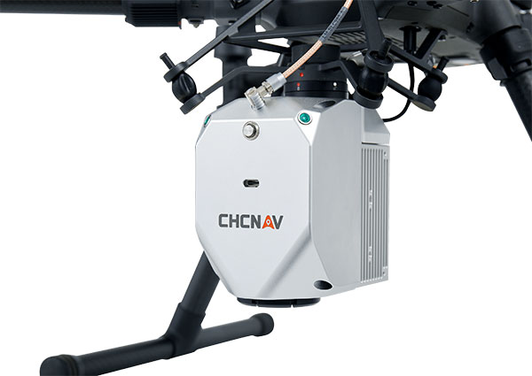
CHC Navigation (CHCNAV) has released the AlphaAir 450 (AA450) lidar system, a lightweight, compact all-in-one sensor for unmanned aerial vehicles (UAVs).
Featuring an inertial measurement unit (IMU), GNSS, 3D scanner and camera, the AlphaAir 450 solution is suitable for power-line inspections, topographic mapping, emergency response, agricultural and forestry surveys. The unit is easy to use, and can be rapidly deployed in the field to collect geospatial data.
“Despite the fact that the lidar scanning is an efficient technology to capture 3D data, it still often remains costly and complex to operate,” said Andrei Gorb, product manager of CHC Navigation’s Mobile Mapping Division. “Taking that into account, we introduce the AlphaAir 450 (AA450), a breakthrough lidar scanner that delivers user-friendly and high-accuracy capabilities at a reasonable price.”
Key aspects of the AlphaAir 450
Lightweight. The lidar’s weight is a constraint for any drone. The AlphaAir 450 weighs 1 kg, which is suitable to most drones’ payload requirements. The lighter the unit, the longer the operating time of the drone, and the greater the productivity. The AlphaAir 450 can be easily mounted on UAVs, making data capture efficient.
Advanced Accuracy. By combining industrial-grade GNSS with a high-precision IMU, the AlphaAir 450 can easily achieve an absolute accuracy of 5 cm (vertical) and 10 cm (horizontal) for small survey areas — typically adequate for the most use cases. To further improve precision and accuracy, users can apply adjustment algorithms in the CHCNAV CoPre software.
Industrial Reliability. Featuring IP64 high-level protection, the AlphaAir 450 extends its operating temperature capabilities, down to –20° C and up to +50° C in any field environment. This can increase users’ return on investment by providing more field survey days in a year.
Avalanches can be a danger for skiers as well as for the resort towns that welcome them. For protection, towns erect steel fences to act as barriers along the ski slopes. But before these snow barriers can be built, steep rock faces and cliffs need to be surveyed.
Darnuzer Ingenieure AG, a Swiss-based surveying and mapping company, uses a drone with a built-in high-performance GPS receiver to survey these harsh areas in hours.
“Drones have made mapping workflows faster, safer and more efficient,” said Septentrio’s senior market access manager Gustavo Lopez. “GNSS technology has led to the evolution of post-processing kinematic (PPK) methods, which help make the photogrammetry process efficient and accurate.”
Every year, thousands of tourists visit Davos in the Swiss Alps. To protect the town and the skiers, avalanche barriers were built along the steep slopes. To plan the work along the uneven rock face, a detailed 3D reconstruction of the area was needed, but getting to the survey site would be a rock-climbing feat.
Darnuzer Ingenieure used the WingtraOne fixed-winged drone, which features a top-quality camera and a Septentrio high-performance GNSS receiver. A single surveyor took the drone to the rocky Parsenn slope during the summer season, capturing ground images — without snow — that were needed for the 3D model.
WingtraOne PPK enabled high-precision mapping without the need for ground control points. During the flight, each image was accurately time-stamped and raw GNSS data from the Septentrio AsteRx-m2 receiver was carefully logged.
Even in this mountainous region, where peaks obstruct the sky, the receiver delivered continuous positioning. The GNSS data was processed by the GeoTagZ software library, which used corrections from a nearby base station to generate real-time kinematic (RTK) centimeter-level positioning.
The GeoTagZ software library incorporated Septentrio’s core GNSS algorithms to assure the best positioning performance. Accurate positioning was then synchronized with the images in the next step of the post-processing workflow.
It only took Wingtra a few days to integrate the GeoTagZ library into its WingtraHub software package. Integration of GeoTagZ into WingtraHub simplifies mapping jobs for customers like Darnuzer Ingenieure.
“The beauty of this solution is that the drone benefits from the receiver’s high-quality raw measurements without the need for a real-time corrections link for accuracy,” Lopez said. “The quality of the measurements comes from the technology built into Septentrio’s receivers, which is designed to be resilient to radio frequency interference and multipath. In post-processing, the GeoTagZ software enables the most accurate positioning, thanks to its high-performance RTK engine.”
Europe’s EGNOS satnav system has been providing safety-of-life services for 10 years. EGNOS, the European Geostationary Navigation Overlay Service, transmits signals from a duo of satellite transponders in geostationary orbit.
The satellite-based augmentation system (SBAS) gives additional precision to U.S. GPS signals, delivering an average precision of 1.5 meters over European territory, as much as a 10-fold improvement over unaugmented signals. EGNOS also provides confirmation of GPS signal integrity through additional messaging identifying any residual errors.
While the EGNOS Open Service has been in general operation since 2009, EGNOS began its safety-of-life service in March 2011.
The European Space Agency (ESA) designed EGNOS as the European equivalent of the U.S. Wide Area Augmentation System (WAAS), working closely with the European air traffic management agency Eurocontrol. ESA then passed EGNOS to the European GNSS Agency (GSA) to run operationally.
Guiding airliners
EGNOS’s primary customer is aircraft. Without guidance from the ground, pilots using EGNOS can confidently descend in bad weather to 60 meters’ altitude before needing to make visual contact with the tarmac.
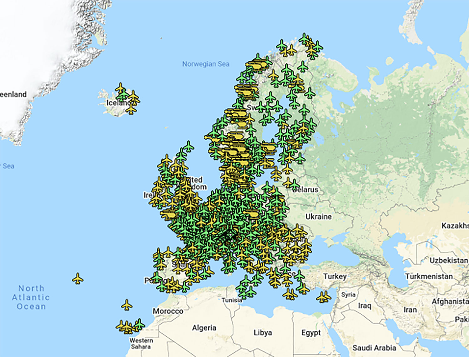
On March 17, 2011, France’s Pau Pyrénées Airport was the first airport to use EGNOS. Today, more than 385 airports and helipads and 60 airlines across Europe use EGNOS-based LPV-200 approaches (short for Localizer Performance with Vertical guidance – 200 feet). The EGNOS service requires no ground equipment, and replaces the radio guidance beamed upward by traditional CAT I instrument landing system (ILS) infrastructure with no decrease in performance.
As of March 2021, more than 385 airports and helipads and 60 airlines across Europe are using EGNOS-based LPV-200 approaches. (Image: ESA)
Serving drones
EGNOS is now being eyed as the enabler of unmanned aerial vehicles (UAVs). The GSA has supported numerous trials of drones equipped with EGNOS as well as Galileo through its EGNSS4RPAS project. Crewed aircraft are expected to be vastly outnumbered in our skies by all kinds of UAVs, employed for everything from weather and environmental monitoring to personalized delivery services.
U-Space is Europe’s program to integrate drones into the airspace. (Image: ESA)
The traditional person-based air traffic control model will need to evolve to accommodate such a shift, based on automated monitoring, traffic management and collision avoidance. In Europe, this highly automated version of air traffic control is termed U-space.
EGNOS’s safety-of-life service is essential to making this happen, moving from today’s situation — where drones are limited to specific air corridors and line-of-sight operations — to let them roam freely but safely in busy airspace and built-up areas.
“The whole idea behind EGNOS’s safety-of-life has been to render satellite navigation sufficiently reliable for any kind of use,” explained Didier Flament, who leads ESA’s EGNOS team. “After 10 years of faultless operations, new applications are becoming plain. Drone flight is one example. EGNOS is also being evaluated for train positioning as well as assisted and autonomous automobile driving.”
EGNOS, the next generation
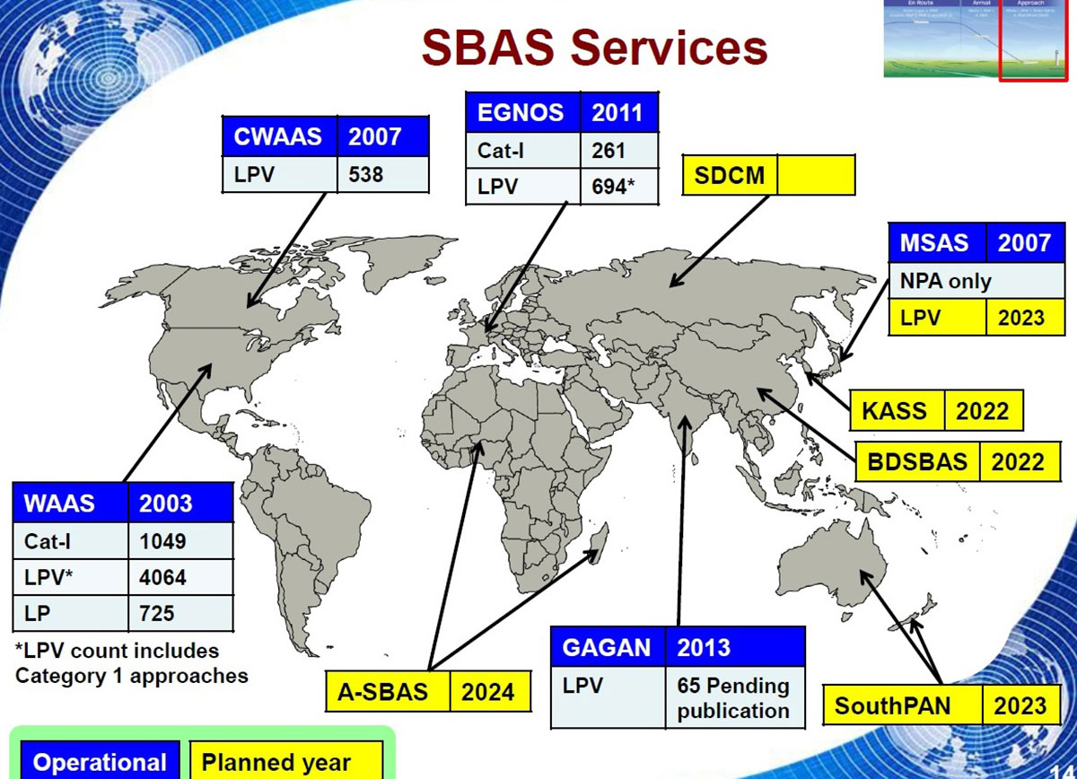
ESA retains responsibility for the system’s evolution, and the middle of this decade should see the debut of its new generation, EGNOS v3.
“While the current system only works with single-frequency GPS signals, EGNOS v3 will operate on a multi-frequency, multi-constellation basis, able to augment all available satellite signals in both L1 and L5 bands, including Galileo,” Didier said. “The result will be far enhanced performance and reliability.
“In addition, we are working with developers of other SBAS around the globe to ensure they stay fully interoperable so for instance EGNOS-equipped aircraft can fly between continents on a seamless basis. Such interoperability, combined with the arrival of the other SBAS systems under development in other regions, will lead to a quasi-global worldwide safety-of-life service coverage in the year 2030.”
Operational and planned satellite-based augmentation systems (SBAS) around the globe. (Image: ESA)
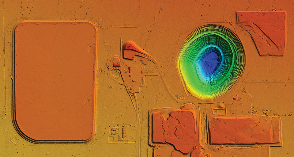
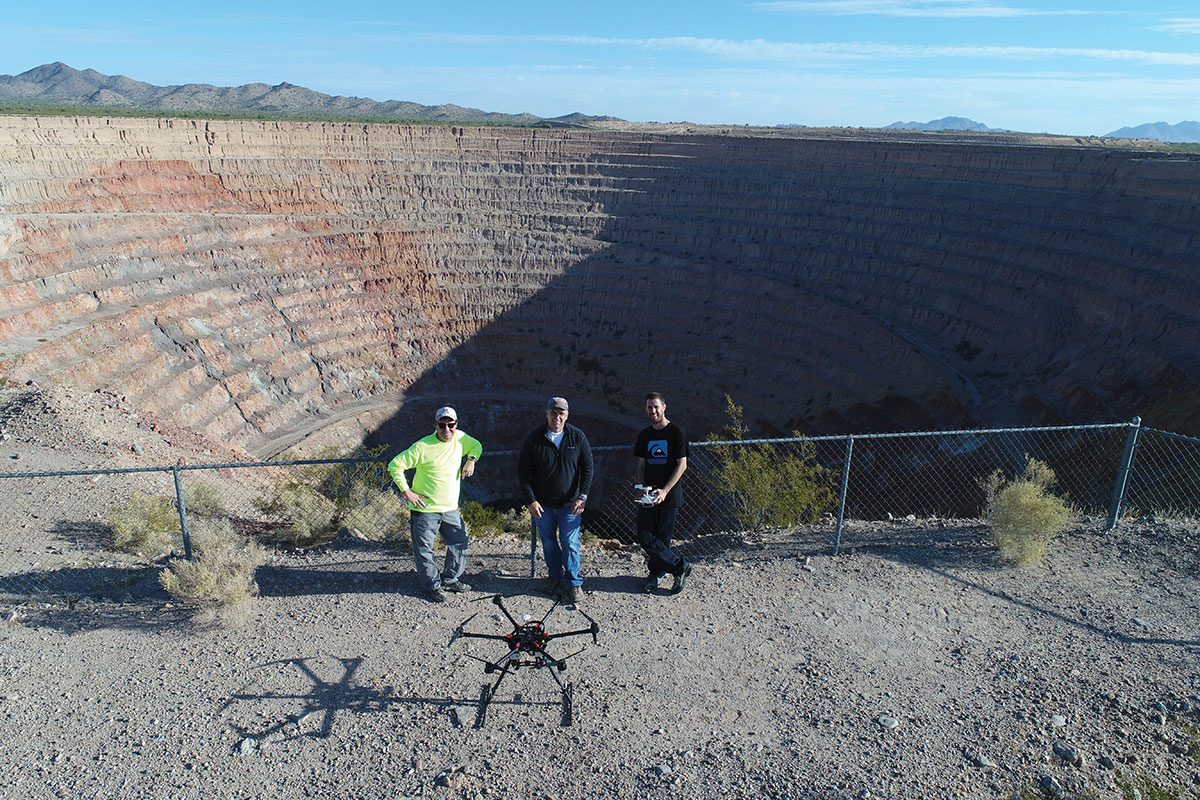
UAVs provided Synergy Geomatics with the safest and most effective way to survey and map a 2,400-acre open-pit mine, and collect about a gallon of water from the bottom of the pit.
The Phoenix, Arizona-based survey, mapping and inspection company took on these two tasks at the Sacaton Mine in Casa Grande, Arizona, which shut down in 1984.
With an old mine of that size, the topographic survey was a large undertaking that lasted several days, said Synergy Geomatics CEO Doug Andriuk. A JAVAD-1M receiver and Triumph-LS real-time kinematic land survey machine were used to set and collect about 80 ground control points.
“This is outstanding survey gear for a large project like this,” he said. “The batteries last 24 hours, the setup takes a couple of minutes, and the multitude of radio options keep us connected all over the project. The dataset was comprised of more than 6,000 images and took several days to process.”
One day of field work followed by 1.5 hours of image capture using a Cessna 172 equipped with the Syn-Cam was required to map the mine.
The company used a proprietary method to collect high aspect imagery of the mine pit, because it allowed for a greater level of accuracy on steep surfaces. Manual and algorithmic filtering removed all the vegetation and structures on the site, and then generated 1- and 5-feet contours.
Collecting water from the bottom of the mine pit presented Synergy Geomatics with several challenges. It had been 30 years since anyone had been to the bottom of the pit, and the roads that led there had washed away long ago.
The use of a manned helicopter was briefly considered, but was not going to work in the tight, 1,500-foot-deep pit.
“We had a better, safer and less expensive solution,” Andriuk said. “We proposed the use of a drone carrying a water-sampling bailer, which is a poly tube with only a one-way check valve on the end. You can dip it in the water, and it will just keep filling up.”
Not only did the drone have to descend 1,500 feet, it had to collect water, too. Testing the drone’s capabilities to collect and carry nearly a gallon of water helped ensure the company would complete the task successfully with a few modifications.
“Multicopters don’t like to descend straight down, as they hit their own propwash, so a spiraling descent has to be made without hitting the walls of the pit,” he explained. “Then the drone must dip the bailer and ensure that it collects the right amount of water.”
Holes were drilled into the bailer to limit the amount of water collected. That way, the drone was not overloaded and could travel safely back to its landing zone with the additional weight.
Determining how high the drone needed to be above the water surface also posed a challenge.
“We opted to use two drones, a large one for the water sample and a smaller drone with a high-definition camera to give the pilot of the first drone clear visibility of the bailer over the water,” he said. “It took four trips, each lasting about 10 minutes, to collect a full gallon of bright green highly alkaline mine pit water.”
DJI now offers dual UAV controllers. Dual operator mode allows a pilot to focus solely on safe operation of the drone, while another operator can focus on payload operations — creating a 3D scan of a location, hoisting or releasing items, or operating a lidar scanner or air-quality sampler.
The DJI Inspire 2 and M600 have dedicated forward-facing video feeds so pilots can see where they are flying, regardless of what the payload camera or other sensors are doing.
Dual controls can ensure safe operation remains the top priority of even a complex and challenging drone flight.
Lidar and photogrammetry payload maker Rock Robotic has finished development of its new Rock R2A payload. Featuring the Livox Avia lidar scanner mounted on an aluminum enclosure, the R2A is light enough to fly on the DJI Matrice 200 and 210 series (versions 1 and 2), Matrice 300 RTK, Matrice 600 Pro, Freefly Alta X and many custom platforms.
A major factor in Rock Robotic’s success has been its use of Inertial Labs’ inertial navigation systems in its payloads. The Rock R2A uses the INS-D-OEM, which features temperature-calibrated and precisely aligned tri-axis micro-electromechanical accelerometers and gyroscopes.
With 20 years in the position, navigation and timing industry, Inertial Labs has been able to develop hardware solutions integrating many different types of sensors to ensure accurate time synchronization among independent data packets, resulting in a guaranteed high-performing system-level solution.
These high-quality systems and components, paired with a robust onboard Kalman filter, result in trajectories with heading accuracies of 0.03 degrees and pitch-and-roll accuracy of 0.006 degrees. These values directly affect point-cloud accuracy, which for the Rock R2A means a system accuracy of 5 centimeters or less.
The advent of drone lidar payloads has had a profound impact on industrial inspections such as for powerlines, saving labor costs and improving safety. The multiple return method of scanning with the Livox Avia and excellent position and orientation accuracy from the INS-D-OEM ensure that the R2A provides a highly dense and accurate point cloud for powerline classification.
“The Inertial Labs team has a deep understanding of the whole navigation technology ecosystem,” said Rock Robotics CEO and Co-Founder Harrison Knoll (known on YouTube as Indiana Drones). “This has made their products offer world-class performance and maintain easy integration and interoperability with GNSS receivers and onboard computer systems.”
“Seen & Heard” is a monthly feature of GPS World magazine, traveling the world to capture interesting and unusual news stories involving the GNSS/PNT industry.
Screenshot: PATS Indoor Drone Solutions video
Seeking out (tiny) aerial threats
Palm-sized drones are eliminating greenhouse pests in the Netherlands, reports the Associated Press. The drones seek out and destroy moths that produce crop-eating caterpillars. Tech startup PATS Indoor Drone Solutions uses drones as greenhouse sentinels. Cameras scan the airspace, and then steer the drones to fly into moths, destroying them in midair. The drone control system can distinguish between good and bad insects. The system is the brainchild of former students from the Delft University of Technology.
Photo: Skydio
Coming soon to a police department near you
Drone-maker Skydio claims to be shipping the most advanced artificial intelligence-powered drone ever built, reports Forbes. The Skydio X2 is scheduled to launch later this year. The quadcopter reportedly can latch onto targets and follow them, dodging all sorts of obstacles and capturing everything on high-quality video. It can fly in tight, tactical situations, such as inside buildings or through a forest. Skydio claims its software can even predict a target’s next move, whether pedestrian or vehicle. American-made, the Skydio is popular with police departments and is often used for defense.
The Loyal Wingman in its first test flight. (Photo: U.S. Air Force 88th Air Wing Public Affairs)
Fighter jets to get a sidekick
A military drone that will accompany fighter jets into combat flew its maiden voyage at the end of February. The Loyal Wingman, designed by Boeing Australia for the Royal Australian Air Force (RAAF), uses artificial intelligence to target enemies. The Loyal Wingman is about the same size as the F-35 jet it will fly alongside. It has a range of 3,700 kilometers. The plane was flown from the ground control station at the Woomera Range Complex in the outback. The RAAF plans to buy three of the drones.
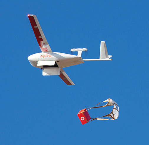
Photo: Zipline
COVID-19 vaccinations air-dropped in Ghana
Ghana has launched a nationwide program that uses Zipline drones to deliver coronavirus vaccines to rural communities. Deliveries began March 2 under the COVAX program of the World Health Organization (WHO), which aims to provide poorer countries with enough doses to cover 20% of their populations. Zipline has been delivering medical supplies (blood, personal protective equipment, vaccines) since 2016 using its patented, autonomous drones.