New modules enable users to develop high-precision solutions for heavy machinery, ground robotics, and unmanned aerial vehicles (UAVs).
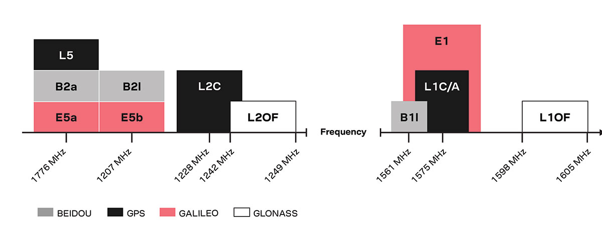
U-blox’s latest multi-band high-accuracy timing modules concurrently support L1 and L5 GNSS signals. The ZED-F9T-10B and LEA-F9T-10B timing modules, and the RCB-F9T-1 timing card, deliver nanosecond-level timing accuracies required to synchronize cellular network base stations and smart power grids. The ANN MB1 L1/L5 multi-band antenna completes the offering.
The multiband capability compensates for ionosphere error from all GNSS satellite constellations and reduces the timing error under clear skies to less than 5 ns without the need for an external GNSS correction service. To achieve maximum performance, the modules track signals from as many satellites as possible.
Image: u-blox
With satellite constellations transmitting signals on the L5 band nearing completion, the L1/L5 signal combination is becoming a viable option to complement products based on L1 and L2 signals. Modernized L5 signals are expected to deliver improved performance, especially in difficult urban conditions. Because L5 signals fall within the protected aeronautical radionavigation service (ARNS ) frequency band, they are also less subject to RF interference.
The LEA-F9T-10B provides a temperature range extended to –40 to +105° C. Both timing modules include a suite of advanced security features, including:
Improved anti-jamming and anti-spoofing technologies detect and flag malicious RF interference.
Secure boot ensures that the modules can only boot with authentic firmware.
Secure interfaces prevent intruders from tampering with the messages between the receiver and the host system.t
The ANN-MB1 L1/L5 multi-band antenna supports the GPS, GLONASS, Galileo and BeiDou, and addresses the scarcity of options in the nascent L1/L5 high-precision antenna mass-market, simplifying testing and deployment of L1/L5 multi-band GNSS solutions. Magnetic and fixed mounting options help meet diverse installation needs.
The new products targets developers in industrial navigation and robotics interested in high-precision positioning technology to locate UAVs, ground robots and agricultural equipment accurately and in real time.
Engineering samples of the u-blox ZED-F9T-10B, RCB-F9T-1 and ANN-MB1 will be available in May, followed by the LEA-F9T.
Altitude Angel, a unified traffic management (UTM) technology provider, is bringing to market airspace management solution GuardianUTM Enterprise.
GuardianUTM Enterprise provides a view of the airspace in the vicinity of airports and enables airport to start designing and providing UTM services for drone companies and drone operators, using Altitude Angel’s proven digital authorization and flight-management technology.
GuardianUTM Enterprise will initially be deployed to support regional and local airports and airfields.
Europe’s EASA U-Space regulations are expected to become law on Jan. 1, 2023. GuardianUTM Enterprise is designed to enable airspace authorities to digitize approvals for drone operations using services integrated with Common Information Service (CIS) and U-Space Service Providers (USSP) architectures.
Using GuardianUTM Enterprise, airports can set access policies and create automation workflows accessible via Altitude Angel’s UTM ecosystem. This ecosystem is used by hundreds of thousands of drone pilots, manufacturers and software companies to guarantee the airport the best available view of the sky and nearby drone operations, ensuring a growing sector of the aviation market is able to access the new airport UTM Service.
For larger airports with counter-UAS solutions, data from on-site surveillance systems can be optionally integrated to give airport security staff greater situation intelligence which is a critical step in encouraging greater drone use.
The solution can be rapidly deployed and configured for airports of any size; providing a flexible platform for enabling drones to be safely integrated in the airspace around these facilities: a crucial step in unlocking a wide variety of unique use-cases for drones.
GuardianUTM Enterprise provides digitalization of pre-flight and take-off approvals to drone operators within airspace. It offers high levels of automation, including customized automated access policies and approval workflows of unmanned operations.
Release follows $1 billion Innovyze acquisition announcement by Autodesk
Water infrastructure software company Innovyze has released Info360.com, a cloud-based, artificial intelligence-powered platform for real-world water lifecycle management.
Combined with Info360 Insight, a data visualization and workflow solution, the platform enables dynamic digital twins for the water industry.
Dynamic Digital Twins are virtual models of real-world assets and systems that can learn and adapt to changing circumstances. Built upon Amazon Web Services (AWS), Info360.com is uniquely designed to support Dynamic Digital Twins by gathering and unifying asset information, connecting live and historic performance data to Innovyze as well as third-party applications.
Autodesk Inc. announced March 1 it signed a definitive agreement to acquire Portland, Oregon-based Innovyze for $1 billion net of cash subject to working capital and tax closing adjustments. Autodesk’s digital-twin strategy creates a clearer path to a more sustainable and digitized water industry, the company said.
This context-aware platform can predict future performance using synchronized computational models that become more intelligent as they’re used. Info360.com provides recommended best-case actions that can help water utilities maintain the highest levels of service, capacity and efficiency.
Due to water system complexity and static operating budgets, many water utilities have struggled to adopt the digital transformation technologies that would allow them to improve predictability and performance. Using the power of the cloud, Info360.com is financially and operationally more accessible, powerful and flexible than traditional on-premise systems.
“The complex, physical properties of water and massive, underground infrastructure that must be monitored and managed make digitization extremely challenging for water utilities,” said Colby Manwaring, Chief Executive Officer at Innovyze. “We’ve combined 35 years of expertise in water management with the power of the cloud to bridge the data and technology gaps that have kept water utilities from truly capitalizing on Digital Twins with our new Info360.com platform. This is a game-changer in making digital transformation achievable for water utilities of any size.”
The new Info360 Insight SaaS application provides utilities with customizable dashboards and KPIs that track and visualize the real-time performance of the entire water distribution system. Performance data can be used and analyzed for daily operations, such as pipe break detection and water loss. The same data can also be used to plan for future maintenance and capacity fluctuations, with seamless integration into the hydraulic model.
“Info360 Insight is the first of several SaaS applications we’re delivering for the Info360.com platform, all offering advantages to utilities like easy onboarding, infinite scalability, and rigorous security out of the box,” said Rick Gruenhagen, CTO at Innovyze. “Better yet, the Info360 platform architecture incorporates cutting-edge technologies like predictive analytics and artificial intelligence tuned specifically for the water lifecycle, allowing utilities of all sizes to stay at the forefront of innovation without the need to maintain complex software or hire hordes of IT experts. As a result, utilities will have the technology foundation they need to deliver the highest possible service at the lowest possible cost.”
Info360 Insight provides real-time ingestion and analysis of SCADA data, along with 24/7 event monitoring, enabling utilities to detect incidents within their infrastructure. The system can check multiple resolution scenarios and apply recommended actions to resolve the failure as quickly as possible — ensuring a higher level of service and reliability.
In the latest edition of this classroom textbook, Getting to Know ArcGIS Desktop 10.8 guides students and professionals through the fundamentals of making maps and analyzing data using the latest Esri ArcGIS Desktop software.
The comprehensive, hands-on tutorial, moves readers from basic GIS concepts to sophisticated GIS analysis. Readers gain practical knowledge about ArcGIS Desktop tools and functionality. Exercises address querying map data, making map layouts, symbolizing and labeling maps, setting map projections, creating and sharing web maps, building and editing geodatabases, and analyzing geospatial data.
Data for completing the exercises and a 180-day free trial of ArcGIS are also available for download.
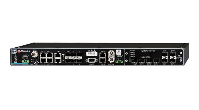
IEEE 1588 precise timing grandmaster with gateway clock now offers software-based redundancy
Photo: Microchip
For today’s critical infrastructure providers — 5G wireless networks, smart grids, data centers, cable and transportation services — a fundamental need exists for a redundant, resilient and secure precise timing and synchronization solution.
Microchip Technology Inc.’s TimeProvider 4100 Release 2.2 grandmaster provides a new level of resiliency with the introduction of an innovative redundancy architecture in addition to support for a multi-band GNSS receiver and enhanced security to ensure always-on precise timing and synchronization.
Redundancy is key for infrastructure providers to ensure uninterrupted services. Infrastructure deployments previously relied on hardware redundancy to avoid service disruption despite costly modular architectures. Microchip’s TimeProvider 4100 Release 2.2 grandmaster provides redundancy via software implementation, enabling flexible deployment and lower hardware costs without sacrificing ports.
In addition, the TimeProvider 4100 Release 2.2 grandmaster introduces an increased level of resiliency by supporting a new GNSS multi-band, multi-constellation receiver to protect against time delay resulting from space weather, solar events and other disruptions that may impact critical infrastructure services.
Multi-band GNSS is particularly important for the highest levels of accuracy, including primary reference time clock class B (PRTC-B, 40 ns) and enhanced primary reference time clock (ePRTC, 30 ns).
With a focus on security solutions across its technology portfolio, Microchip’s new TimeProvider 4100 Release 2.2 grandmaster adds support for RADIUS and TACACS+ as well as new anti-jamming and anti-spoofing capabilities.
“Resilient, redundant and secure precise timing and synchronization solutions are necessary to mitigate security risks to critical infrastructure,” said Randy Brudzinski, vice president and general manager of Microchip’s frequency and time business unit. “This latest release brings an innovative software redundancy that enables always-on technology as well as support for multi-band GNSS to eliminate ionospheric time error delays. It provides new key security, anti-jamming and anti-spoofing so critical infrastructure services can be accessed only by authorized, authenticated personnel.”
In addition, the TimeProvider 4100 Release 2.2 grandmaster provides a super oven controlled crystal oscillator (OCXO) option for enhanced holdover capabilities in case of GNSS disruption.
The TimeProvider 4100 Release 2.2 grandmaster is a family of products with hardware expansion modules for legacy fan-out or Ethernet fan-out with 10 Gigabit Ethernet support. It can be configured in specific operation modes to act either as a gateway clock, a high-performance boundary clock or an ePRTC.
The TimeProvider 4100 Release 2.2 grandmaster embeds additional Microchip technology including its OCXO, super OCXO, rubidium atomic clock, field-programmable gate arrays (FPGAs), Ethernet switch, synthesizers and cleaning oscillators.
The TimeProvider 4100 is part of Microchip’s Virtual Primary Reference Time Clock (vPRTC) product portfolio, offering end-to-end precise time and synchronization solutions. These include Cesium atomic clocks for source of frequency and time, the BlueSky GNSS Firewall for security, TimeProvider 4100 high-performance boundary clock and TimeProvider 4100 Gateway clocks, as well as the TimePictra software suite, which manages the end-to-end precise time architecture across all Microchip timing products.
Microchip’s TimeProvider 4100 Release 2.2 grandmaster offers several options for software and hardware support including installation, sync audits, network engineering and 24/7 worldwide support. It is available now for both new and already-deployed systems.
It’s hard to pick out an outstanding story or two this month from the dozens of new or related drone initiatives that bombard my inbox. But there’s always some that stand out, needing emphasis. This month, we look at these developments:
NEC Laboratories Europe introduces a potential drone solution for finding disaster victims
The FAA issues its remote ID rule, which also enables flight over people and nighttime operations
The Boeing Loyal Wingman succeeds with its maiden flight in Australia.
Search-and-rescue drone
Finding survivors is a primary task for first responders in disaster situations, so if a feasible approach using drones looks possible, its something we should prove out and implement quickly. Researchers at NEC Laboratories Europe, based in Germany, have come up with a drone shown to be able to locate a person’s cell phone — it works better in open situations, but takes longer and is less accurate when there are obstructions.
The Search-and-Rescue Drone (SARDO). (Photo: NEC Labs/Antonio Albany)
The concept of the search-and-rescue drone (SARDO) is basically to hang cellphone-tower electronics on the drone, and then let it self-triangulate on the return signal from the victim’s phone. So if you know where you are and estimate distance by pinging the victim’s phone and measuring the transit time, then move a known distance and repeat, eventually you converge on the phone’s location.
Putting all that into reliable flying algorithms is something; proving that your design works is significantly more tricky. Overcoming signal blockage due to debris brings another level of complexity, as does tracking the victim if he or she is moving.
But this looks like a great initiative which should be developed further — a possible boon for finding people in earthquakes and other building-collapse situations.
FAA Remote ID Rule issued
Image: ConceptCafe/iStock/Getty Images Plus
On Jan. 15, the U.S. Federal Aviation Administration (FAA) finally issued its rules for remote ID: All UAVs greater than 0.55 pounds must transmit unique identifications. Although, it appears that even these lighter drones might also have to be capable of remote ID if operated commercially. The broadcast message has to include “identification, location, and performance information of the unmanned aircraft and its control station.”
The good news is that there are now several potential suppliers of these broadcast modules. The rules allow for an implementation period that stretches out another 18 or 30 months — UAV manufacturers have 18 months to comply, while drone operators have 30 months.
The rules also allow drone operators to fly their UAVs over people. There are four categories of drone, each with appropriate restrictions — all seemingly related to the injuries an out-of-control or falling drone could cause to a person. All such operations require that the FAA approve a written statement of compliance with these safety rules.
The rules will certainly help with coverage of spectator sports such as the Super Bowl and regular outdoor events like PGA golf tournaments. It would appear that the Golf Channel and CBS have already begun to broadcast drone coverage of recent golf events. Such operations needing to verify their compliance now, rather than over the implementation period.
And, of course, if you can fly over people, transiting over vehicles is now allowed. With an anti-collision light installed, night operations are also permitted once compliance is approved.
The UAV/UAS is also referred to as the Airpower Teaming System (ATS), and should likely be considered a contender for the U.S. Air Force Skyborg manned-unmanned teaming program. At least two other companies involved with the Skyborg program are already flying similar vehicles — Kratos Unmanned Aerial Systems and General Atomics Aeronautical Systems.
Summary
Anything that helps first responders find survivors in disasters is a good idea to take to users in the field as soon as possible, so the NEC Laboratories Europe initiatives is a welcome opportunity.
After more than two years to get the final rules published, the FAA is finally coming online with its Remote ID rule — even though it entails significant work on operators’ parts over the next several months for them to implement. But the window now seems to be significantly wider for them to be able to take on more viable commercial business ventures.
Finally, it’s good to see the Boeing ATS get into the air — the first aircraft in 50 years to be wholly built in Australia, with interest not only from the Australian RAAF, but also with potential participation in the USAF Skyborg program.
Among the enhancements, a doubling of the update rate means the GSS9000 series now offers the ability to recreate operations more precisely and realistically, reducing uncertainty in positioning, navigation and timing (PNT) testing.
The latest developments provide the GSS9000 series with the ability to run simulations at a software and hardware update rate of up to 2 kHz, improving accuracy of the simulated trajectory without compromising performance. This is of particular benefit to high-dynamics applications, such as space missions and hypersonic vehicles. The increased update rate also delivers lower latency for hardware-in-the-loop (HIL) testing, further reinforcing the GSS9000’s position as the industry’s most accurate and realistic test instrument.
“Our dedicated hardware and powerful software solutions are built specifically with PNT test in mind — to improve accuracy, increase flexibility and provide high-performing systems to meet customer needs,” said Adam Price, Spirent director of PNT simulation. “These latest enhancements to the GSS9000 continue to raise the bar for highly flexible and scalable solutions that enable our customers to stay ahead of their competition.”
Other enhancements to the GSS9000 Series include:
Extended Scenario Duration. In a simulation environment, where control and repeatability are key for a realistic representation of the mission, reducing the number of user inputs is essential. The new update will extend the available scenario duration to 65 days, using the same initial conditions for the simulation throughout the duration of testing to deliver uninterrupted high-performance simulation for longer.
Enhanced Embedded Interference Capabilities. To provide greater power and flexibility in interference testing, Spirent has improved support for interference testing on wide spectrum signals, increased bandwidth resolution and repetition rates, and added variable bandwidth control on additive white Gaussian noise (AWGN).
“Spirent’s leadership in GNSS testing comes from the combination of our unrivalled heritage and deep understanding of the PNT market, alongside our continuing commitment to improving test capabilities for customers,” said Ricardo Verdeguer Moreno, product line manager for high-end applications. “By working closely with customers, we are able to better understand the challenges they face, and these latest enhancements to the GSS9000 series demonstrate how we are continuing to help customers reduce uncertainty by providing more accurate operations, without impacting system performance.”
The enhancements to the Spirent GSS9000 series will be available to new and existing customers at the beginning of the second quarter of this year. For more information, visit the GSS9000 Series product page. U.S. government and prime contractors should contact Spirent Federal for details.
In our 10th annual Simulator Buyers Guide, we feature simulator tools, devices and software from 10 prominent companies that aid GNSS receiver manufacturers in product design.
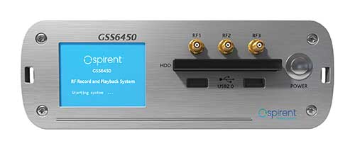
The GSS6450 RF record and playback system. (Photo: Spirent)
GSS9000, SimMNSA, CRPA test system, anechoic chamber testing, mid-range testing
Spirent Federal Systems provides PNT/GNSS test equipment that covers all applications, including research and development, integration/ verification, and production testing.
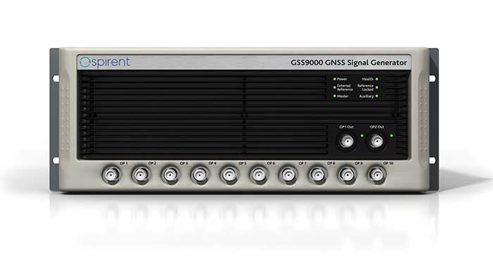
GSS9000. The GSS9000 Series Multi-Frequency, Multi-GNSS RF Constellation Simulator is Spirent’s most comprehensive simulation solution. It can simulate signals from all GNSS and regional navigation systems and has a recently-enhanced system iteration rate (SIR) of 2 kHz (0.5 ms), enabling higher dynamic simulations with more accuracy and fidelity. The GSS9000 supports restricted/classified signals, Alt RF, and other non-GNSS sensors. Users can evaluate the resilience of navigation systems to interference and spoofing attacks, and have the flexibility to reconfigure constellations, channels, and frequencies between test runs or test cases.
The GSS9000 Constellation Simulator. (Photo: Spirent)
SimMNSA. Spirent Federal has the first fully-approved MNSA M-code simulator. Authorized users of the GSS9000 series of simulators will be able to utilize the advanced capabilities of SimMNSA to create more robust solutions for their customers. SimMNSA has been granted security approval by the Global Positioning System Directorate.
CRPA Test System. Spirent’s Controlled Reception Pattern Antenna (CRPA) Test System generates both GNSS and interference signals. Users can control multiple antenna elements. Null-steering and space/ time adaptive CRPA testing are both supported by this comprehensive approach.
Anechoic Chamber Testing. Spirent’s GSS9790 Multi-Output, Multi-GNSS RF Constellation Wave-Front Simulator System is a development of the GSS9000. The GSS9790 provides the core element for GNSS applications that require a test system that can be used in both conducted (lab) and radiated (chamber) conditions.
Mid-Range Solutions. Spirent also offers solutions that cater to intermediate GPS/GNSS testing needs. The GSS7000 multi-constellation simulator provides an easy-to-use solution for GNSS testing that can grow with users’ requirements. The GSS6450 RF record and playback system enables repeated replay of a real-world GNSS/GPS test in the lab.
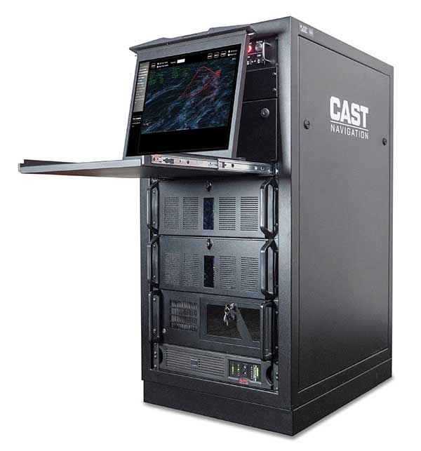
CAST-CRPA. The CAST-CRPA Simulation System produces a coherent wavefront of GPS RF signals to provide repeatable testing in the laboratory environment or anechoic chamber. The CAST CRPA system is configurable for any number of coherent outputs that users want.
With an intercard carrier-phase error of less than 1 millimeter, the CAST-CRPA Simulation System is extremely accurate.
The system generates a wavefront of GPS signals when its GPS RF generator cards are operated in a ganged configuration. Each generator card provides a set of GPS satellites coherent with the overall configuration. Several RF generator cards may be utilized together, ensuring phase coherence among the signal generator cards in each bank. The CRPA antenna, the antenna electronics and the GPS receiver can be tested as a unit with or without radiating signals.
CAST-CRPA features
Generates single coherent wavefront of GPS signals
Orolia advanced GNSS simulators offer a wide breadth and depth of simulation tools to test mission-critical positioning, navigation and timing (PNT) applications and scenarios. They are feature-rich and easy to use, providing a way to harden GPS/GNSS-based systems without the limitations of live-sky testing.
Skydel — Advanced Software-Defined Simulators
Skydel Simulation Engine. This flexible, high-performance simulator transmits GNSS digital signals in real time to many kinds of software-defined radios. Skydel uses graphics processing units (GPUs) to compute the digital GNSS signals of all simulated satellites, scaling from simple to complex use cases. Skydel simulates civil signals from global and regional navigation satellite systems, many kinds of GNSS receiver trajectories with high dynamics, and advanced jamming and spoofing. All Skydel models offer these features:
Easy configuration with intuitive UI and automation
Support for global constellations and frequencies
Support for jamming, spoofing and repeating, including jamming waveforms
Comprehensive API (Python, C#, C++, LabVIEW)
Advanced signal customization and scenario creation
Ability to integrate interference with no additional hardware
1000-Hz simulation iteration rate
IQ file generation and playback
Ability to record and export user interactions as Python script
GSG-8. This software-defined system GSG8 is a globally available hardware platform for aerospace and critical infrastructure applications. It will support future EU encrypted signals. The rack-mounted unit has the option of one to four RF outputs and is configurable.
BroadSim. Designed for military NAVWAR applications, the BroadSim software-defined simulator supports encrypted military codes (Y-code, M-AES and M-MNSA) and provides documentation and procedures for classified operations. BroadSim has two GPUs and four RF outputs. It runs on a custom Linux operating system, with RMF STIG support coming soon.
Skydel Anechoic. This simulator system for radiated over-the-air testing is designed for testing CRPA/multi-element antennas, antenna electronics and entire PNT systems in an anechoic chamber.
Skydel Wavefront. This GNSS simulator system for conducted wavefront testing is designed to test the jamming/spoofing resiliency of CRPA and multi-element antenna electronic systems, and for applications with high dynamics.
GSG 5/6 Scenario-Based Simulators. The GSG 5/6 enable testing of smart applications such as drones, the internet of things, connected cars and cellular. They provide a comprehensive set of pre-defined scenarios and the ability to create scenarios. They simulate all constellations and frequencies as well as movements and trajectories anywhere on or above Earth.
Application packages are available for real-time kinematic, eCall, high-velocity, jamming and sensors.
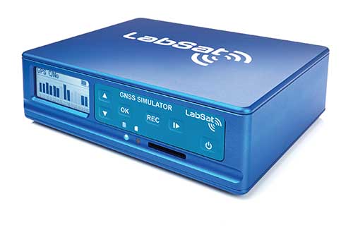
LabSat 3 Wideband. The LabSat 3 Wideband is a compact yet powerful multi-constellation and multi-frequency GNSS testing solution. The easy-to-use, one-touch record-and-replay function provides an efficient way to test and develop GNSS-based technology without the cost and limitations of live-sky signals.
It is lightweight and portable and makes it easy to collaborate with colleagues by sharing scenario files over the internet — making it a suitable testing partner for remote working. Additionally, the removeable solid-state drive (an SSD of up to 7 terabytes) and a two-hour runtime provided by an internal battery is ready for field testing in any environment.
LabSat 3 Wideband can record and replay up to three different channels at 56-MHz bandwidth across all major constellations and signals, including:
GPS: L1/L2/L5
Galileo: E1/E1a/E5a/E5b/E6
GLONASS: L1/L2/L3
BeiDou: B1/B2/B3
NavIC: L5/S-band
QZSS: L1/L2/L5
L-band correction services including SBAS
2x CAN and 4x digital input channels tightly synchronized with GNSS data
Future signal launches are also supported, including L2C, L5 and L1C
SatGen Simulation Software. SatGen software allows users to quickly create bespoke, accurate scenarios with their own time, location and trajectory that can be replayed via a LabSat GNSS simulator.
The latest version of SatGen can be used to create a single scenario containing all the upper and lower L-band signals for GPS, Galileo, GLONASS, BeiDou and NavIC.
High-end GNSS simulation solutions for R&D, integration and product testing
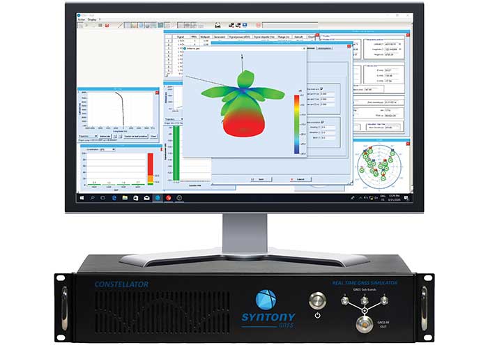
Constellator. Syntony’s GNSS simulator Constellator supports all constellation signals available and provides a high level of service in different ranges. It covers, in a single unit, a wide spectrum of use cases from entry-level with L1C/A up to very demanding configurations such as multifrequency and up to 660 L1C/A-equivalent signals. Extensively used in aeronautics, space and defense industries, Constellator answers complex requirements:
Standalone mode (on the ground and in space)
Multi-frequencies
All constellations and their signals, including BeiDou, Navic/IRNSS and QZSS
Hardware-in-the-loop (HIL) mode with zero effective latency and 1000-Hz update rate
CRPA generation capability
Capability to generate “Restricted Signals” through a dedicated interface, called PRN-Link
In the space industry, Constellator implements the advanced models (Earth gravity, drag, 3D ionospheric models, side lobes, etc.) needed to achieve accurate simulations for all kinds of orbits (from LEO to GEO and SSTO). Combined with other Syntony GNSS simulation products (interference generator, Echo recorder and player), Constellator can tackle challenging use cases such as testing of jamming, spoofing, multipath and multiple antennas. It is based on a software-defined radio, making it hardware-ready for future constellations, signals and codes. It is easily upgradeable and versatile.
GNSS Recorder and player. Echo is an ultra-high-fidelity GNSS record-and-playback solution that captures real-life signals and environments — for instance, from airplanes — and then replays them for R&D or production tests. Echo offers:
3 RF channels of 100-MHz bandwidth each (for the whole set of GNSS signals from all constellations)
16-bit resolution (I&Q)
From seven to more than 1,000 hours of record/replay capabilities depending on the configuration
The Echo platform allows full 16 bits of I/Q recording at 100 Mhz for three channels, simultaneously. As such, it provides the highest achievable record/replay fidelity. Echo-R can also record complex and very long realistic scenarios from a simulator. Echo-P can replay them with very high fidelity for long-run or production tests.
Please contact Remy Thellier (based in San Francisco) for North America at 415.599.9230, or contact the EMEA Sales team at: [email protected] syntony-gnss.com
+33.5.81.319.919
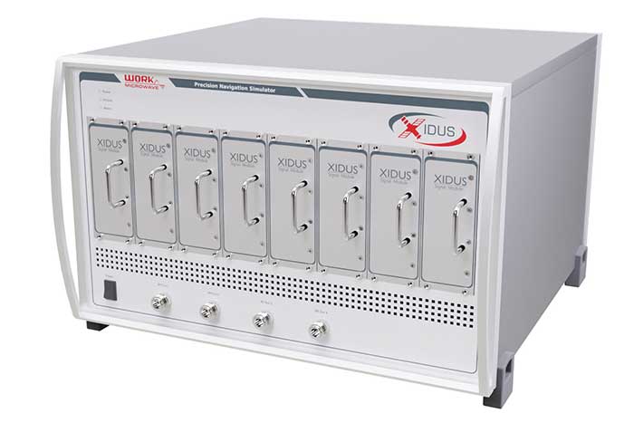
The advanced customization and configurability of Xidus enables users to perform rigorous and extensive testing of GNSS systems.
Test scenarios. Xidus meets all requirements regarding multi-GNSS, multi-frequency and multi-RF signal generation out of the box. Innovative Xidus signal extension and enhancement (SEE) technology allows users to integrate bespoke generation blocks into the signal generation path. In addition, Xidus’ advanced support capabilities allow remote support and updates, remote training and even remote scenario execution.
Easy hardware or software upgrades. Xidus has modular signal generation hardware that allows easy and robust field upgrades. New modules are automatically calibrated, allowing users to accomodate multiple concurrent navigation development projects.
Expert background. WORK Microwave has been designing and building GNSS simulators for more than 15 years. The Xidus hardware leverages WORK Microwave’s 35+ years of experience in the design and manufacturing of bespoke digital and analogue microwave products.
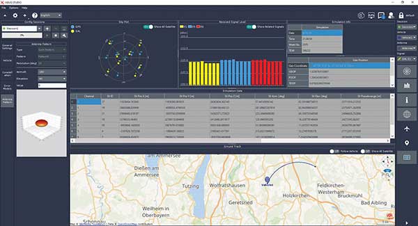
Xidus-Studio (Photo: Work Microwave)
Xidus-424 GNSS Simulator. The Xidus-424 has up to 128 LOS channels, 512 multipath channels and two RF outputs. It supports all GNSS frequencies and signals. It supports an update rate up to 100 Hz and has very wide dynamic power range configurability.
Xidus-648 GNSS Simulator. The Xidus-648 provides all the capabilities of the Xidus-424 plus additional features: up to 256 LOS channels, 1,024 multipath channels, four RF outputs and a 1000-Hz update rate.
Xidus-Studio client software. The software provides everything for testing GNSS systems: different vehicle models with 6DOF, multiple vehicle simulation, spoofing and meaconing, multiple TX antenna patterns, multiple RX antenna patterns, industry-standard error models and runtime distortions on individual channels. Xidus-Studio also allows the design of bespoke satellite orbits ranging from LEO to GEO. Available on Linux and Windows.
Xidus Series. Connect up to four Xidus units to produce a simulator capable of mega-constellation simulation, with precise phase synchronization across units.
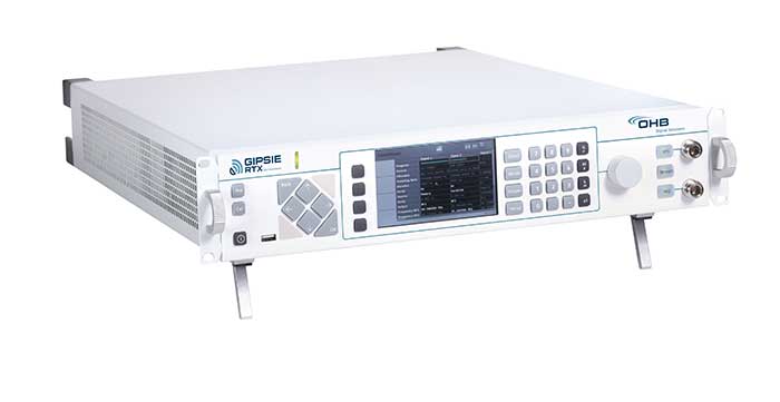
GIPSIE-RTX (GNSS Multisystem Performance Simulation Environment – Real Time Extension)
GIPSIE-RTX is a fully featured GNSS signal generator with real-time streaming functionality, including real-time control of the simulation environment. It consists of a high-quality signal simulator as the hardware platform and a flexible and powerful GNSS simulation environment.
The multi-system and multifrequency-capable GIPSIE-RTX simulates arbitrary satellite orbits using a sophisticated orbit integrator. It is able to model all error sources, delays and propagation effects. These include various models for satellite clocks, ionosphere and troposphere, multipath, signal power, antenna patterns and noise. In addition, multiple types of signal interference, like jamming and spoofing, can be defined. Customized navigation message formats and contents can be used to simulate future GNSS signal features.
Besides generating RF signals, GIPSIE-RTX is also capable of directly simulating digital signals, taking into account user-defined modeling of a radio-frequency front end. Comprehensive data logging of all intermediate results is available for detailed analyses.
GIPSIE-RTX provides a real-time input interface and thus supports hardware-in-the-loop (HIL) testing, such as for automotive applications.
GIPSIE-RTX Features
GIPSIE-RTX is a new compact multi-channel high performance platform for complex and versatile GNSS testing. Features include:
Highly reproducible scenarios
Modeling of all error sources, delays and propagation effects
Interference (jamming and spoofing) simulation
HIL simulation
Synchronization of multiple simulators for advanced testing (e.g., array antenna)
QA707 is the cutting edge solution for global threat GNSS awareness and management. It is a GNSS simulator specifically designed to test cyber-attacks and authentication, and includes the simulation of GNSS interference, deception, jamming, spoofing and advanced cyber-threats such as data and code level attacks.
The high flexibility in the creation of the scenarios and the definition of the type of attacker allow cyber-threat and vulnerability testing for several applications,These applications may include, for example, autonomous driving and vehicle tracking, aeronautics and high dynamics applications, space GNSS receivers and timing.
OSNMA support. The Galileo Open Service Navigation Message Authentication (OSNMA) simulation is an opportunity to test the new Galileo data protected service against a number of known vulnerabilities in GNSS applications. The OSNMA simulator is also available as a standalone tool, allowing the generation of OSNMA data that can be used with third party simulators.
PC-capable. QA707 runs on a standard PC. It is compatible with several third-party hardware RF up-converters, including National Instruments’ USRP. Additionally, it can support customer-specific hardware through the hardware API interface.
QA707 main features
Multi constellation (currently GPS L1, GALILEO E1, SBAS L1).
Galileo OSNMA
RF simulation, binary file dump, signal record and replay
Support to SDR platforms and open API for custom RF upconverters
Runtime streaming of scenario information over UDP (motion, channel data)
Data level cyber-attacks
Accurate spoofing signals control, trajectory spoofing, signal replay attacks
Narrow band, wide band, frequency modulated jamming
Integrity threats (on request): evil waveform, erroneous ephemerides, code/carrier divergence, low satellite signal power, excessive range acceleration
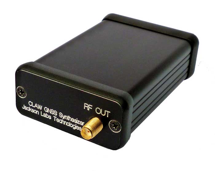
The 18-channel miniature full-constellation CLAW GPS Simulator is a fully self-contained, low size, weight, power and cost (SWaP-C) miniature GPS simulator. It is very popular in manufacturing environments as well as R&D applications that require consistent and repeatable local GNSS signals at low price points.
The CLAW simulator does not require external computers for processing and control — it works fully self-contained by simply applying power, and storing location/time/date data in internal non-volatile (NV) memory, or by storing complex vector data to simulate highly dynamic scenarios.
The CLAW also can be used to transcode NMEA or SCPI position/velocity/time (PVT) data into GPS RF signals. JLT offers an easy to use, highly configurable and cost-free SimCon Windows application program that is downloadable from the JLT website.
The SimCon application allows random scenario generation and is thus usable to simulate leap-second events, week 1023 rollover events, or any other GPS live-sky scenarios, including highly complex yet easy-to-create dynamic vector simulations.
For authorized U.S. government users, a version that does not have altitude and velocity limitations is popular for low-Earth-orbit (LEO) simulations. Multipath simulation allows use of the entire 18-channel simulator capability.
The unit can be field-upgraded with an easy to use in-field software upgrade feature. The CLAW is also very useful in GNSS receiver sensitivity testing for R&D or mass-production assembly lines as it allows accurate control of RF output power ranging from –100 dBm to less than –130 dBm with 0.1-dB resolution and typically better than 1-dB accuracy over the controllable power range.
The CLAW GPS Simulator also has a built-in RF signal generator with sweep, CW and random noise functions that are useful in simulating GNSS jamming scenarios, as well as GPS spoofing scenarios. The simulator comes in an FCC-certified metal desktop enclosure with numerous accessories.
For 2021, the CLAW firmware has been updated to allow live-sky almanac and ephemerides to be automatically uploaded from various externally connected GNSS receivers. This makes simulations using real-time live-sky constellations (such as used in simulating spoofing attacks) an easy task. A free firmware update is available from JLT.
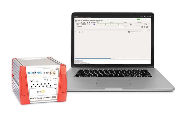
The MGSE product family creates a versatile GNSS test and simulation environment that improves the development, qualification and certification process of GNSS receivers within development phases and for the validation and certification in end-to-end tests.
MGSE enables mobile and stationary interference monitoring, such as for protecting critical infrastructures (based on MGSE REC), and can be used for interference mitigation if combined with TeleOrbit’s GNSSA-6E (six-element antenna array) or its GNSSA-DCP (dual circularly polarized antenna).
With MGSE REC-REP 2.0 users can, among other tasks, record Galileo PRS signals in a real user environment and replay them for Galileo PRS receiver testing. It is also possible to replay simulated GNSS signals.
MGSE SIM-REP supports the development of software-defined radios/receivers (SDR) or specialized algorithms by creating a simulation environment that provides the possibility and flexibility to use synthetically generated GNSS data and recorded real-world samples — both exactly reproducible.
For jamming and spoofing test and evaluation, TeleOrbit offers a sophisticated solution based on the MGSE simulation, recording and replaying product family.
Technical background. The multi-band RF front-end (MGSE REC) receives the GNSS RF signals in different frequency bands simultaneously to obtain digital IF data, which can be used for GNSS multi-system signal analysis and comparison.
MGSE REC also includes a reception board to receive and process the NavIC S-band signal in addition to other L-band frequencies.
The MGSE Replay Unit (MGSE REP) includes a flexible multi-band RF replay device that can stream simulated and recorded raw IF data to a digital baseband output or to an analog RF signal.
MGSE REP simultaneously supports up to two independent RF channels and up to four GNSS signals, such as L1, E1, B1, G1.
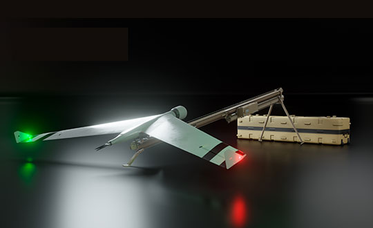
Zala Aero Group unveiled the ZX1, a new hybrid unmanned aerial vehicle (UAV), at the 2021 International Defense Industry Exhibition (IDEX) and Conference, which opened on Feb. 21 in Abu Dhabi.
The new drone has vertical-takeoff-and-landing (VTOL). According to Zala, it combines the best qualities of fixed-wing and multirotor types of UAVs; its configuration can change depending on the conditions of the performed task.
Ease of operation allows the UAV system to reduce the operator’s role, decrease the amount of equipment used when performing a flight mission, and fully automate flight processes of the UAV.
The ZX1’s onboard computer uses artificial intelligence, which makes it possible to process data in full high-definition, and transmit HD video and photos via encrypted communication channels to the GCS, ensuring the effectiveness of monitoring even before the aircraft lands.
The VTOL design makes it compatible with existing ZALA payloads, and also allows the installation of additional surveying equipment. It can be used to perform air monitoring for the fuel and energy sector and search-and-rescue operations from sites in urban environments.
Zala Aero Group, founded in 2004, is a Russian developer and manufacturer of unmanned aerial systems, payloads and mobile systems. It is now part of Concern Kalashnikov. Its main products are reconnaissance unmanned systems and digital solutions. Currently, more than 2,000 of Zala UAS operate within Russia. Areas of application are the protection of state borders, reconnaissance and rescue operations, monitoring of high-risk facilities and emergencies.
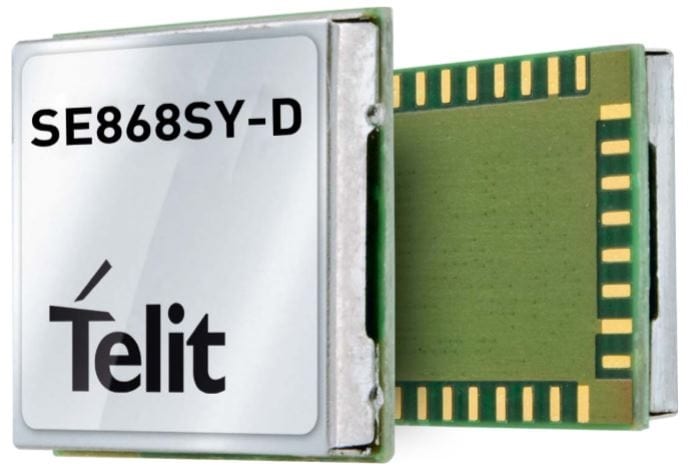
Telit has launched the SE868SY-D multi-frequency, high-precision GNSS receiver module for applications that require high accuracy, fast updates, multi-constellation support and multipath resistance.
At 11 x 11 mm, the SE868SY-D accommodates ultra-compact devices and IoT trackers.
Available now, the high-precision SE868SY-D module is Telit’s first multi-frequency, multi-constellation GNSS receiver module, featuring an ultra-sensitive -167 dBm (tracking) RF front end. By using both the L1 and L5 bands, the SE868SY-D supplies a significantly higher location accuracy than single-frequency devices — even in high-multipath environments such as urban canyons, Telit said.
This sub-1-meter precision is a major reason ABI Research expects more than 1 billion multi-frequency GNSS devices to ship annually by 2023.
The SE868SY-D is the first product from a new strategic collaboration between Sony and Telit, and features Sony’s next-generation CXD5610 GNSS receiver large-scale integrated circuit (LSI).
The Telit SE868SY-D is designed for battery-powered applications such as IoT trackers and wearables. With less than 45 mW in L1+L5 tracking mode, the module has low power consumption, despite using both L1 and L5 bands.
For high-dynamic applications, the SE868SY-D a high update rate of up to 25 Hz. Its high-accuracy, one-pulse-per-second signal also makes the module suitable for timing applications.
“With the new SE868SY-D, Telit is uniquely prepared to meet the burgeoning global demand for multi-frequency, multi-constellation GNSS receivers for IoT trackers, wearables and more,” said Eric Lagorce, Telit business development director. “The SE868SY-D also perfectly complements Telit’s two decades of GNSS expertise and its broad portfolio, and highlights the potential of our strategic collaboration with Sony.”
The Telit SE868SY-D provides pin-to-pin compatibility for applications based on Telit’s legacy GPS module JF2 and GNSS module SE868V3.
Lockheed Martin, the prime contractor for GPS III/IIIF, selected L3Harris in 2018 to design and build the first two fully-digital MDUs, the heart of the satellite’s navigation payload. (Artist rendering: Lockheed Martin)
L3Harris Technologies has received contracts totaling $137 million for four navigation payload Mission Data Units (MDU) for future GPS III Follow-On (GPS IIIF) satellites.
Lockheed Martin, the prime contractor for GPS III/IIIF, selected L3Harris in 2018 to design and build the first two fully-digital MDUs, the heart of the satellite’s navigation payload. The MDU generates more powerful GPS signals and assures clock operations for GPS users, L3Harris said.
“The digital MDU is flexible enough to adapt to advances in GPS technology and future changes in mission needs,” said Ed Zoiss, president, Space and Airborne Systems, L3Harris. “The new MDU will also support a smooth transition for the U.S. Space Force’s GPS OCX ground control segment.”
The U.S. Space Force expects the first GPS IIIF satellite, which builds on GPS III adding new capabilities and technology, to be available for launch in 2026. According to L3Harris, the GPS IIIF MDU will provide improved capabilities over L3Harris’ 70-percent-digital MDU on the first ten GPS III satellites. The first four GPS III satellites have successfully launched and are now operational in the GPS constellation.
L3Harris Technologies is a global aerospace and defense technology innovator, delivering end-to-end solutions that meet customers’ mission-critical needs. The company provides advanced defense and commercial technologies across air, land, sea, space and cyber domains.
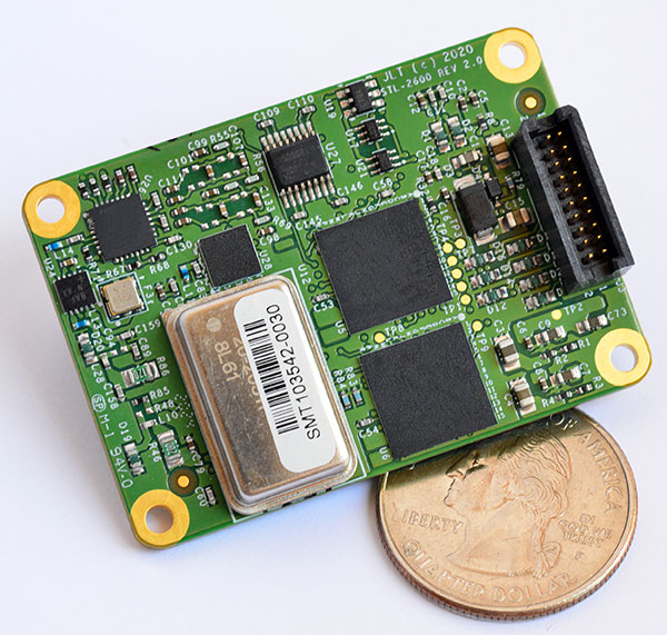
The STL-2600 STL-capable receiver provides a GNSS-independent low SWaP-C UTC-time and location capability
Jackson Labs Technologies Inc. (JLT), a designer and manufacturer of GNSS, timing and frequency equipment, has announced the availability of the STL-2600 Satellite Timing and Location (STL) receiver designed in partnership with Satelles Inc., the STL service provider.
The STL-2600 commercial receiver provides a completely GNSS-independent, low-cost capability to generate UTC nanosecond timing and meters-accurate positioning anywhere in the world. It operates in a way similar to GPS, but without GPS or GNSS. The STL signal has 30-db (1,000 times) higher power compared to GPS signals, allowing the receiver to operate deep indoors independent of any GPS/GNSS signal.
“Useful for non-GNSS-based E911 location and UTC(NIST) timing applications, the STL-2600 receiver is deployable today to fulfill critical infrastructure PNT objectives such as those outlined in Executive Order 13905 on the responsible use of PNT in the U.S. and the emerging mandates for a GNSS-independent backup solution in Europe,” said Said Jackson, president of JLT.
The STL-2600 receiver is also useful in marine applications where GNSS signals are regularly denied or manipulated and for stationary high-accuracy timing applications such as 5G.
The STL-2600 receiver can be directly connected to JLT’s GPS Transcoder products for glue-less retrofit capability of existing customer legacy GPS-only receiver systems to Galileo, GLONASS, BeiDou, QZSS and SBAS as well as adding the STL and optional atomic holdover capability to these legacy systems.
The receiver module combines a custom-designed STL L1 LEO receiver and a latest-generation concurrent-GNSS receiver with a disciplined high-stability reference oscillator sub-system on one circuit board.
Features and specifications of the STL-2600
Photo: JLT
Form factor: 1.4″ x 2.0″ x 0.5″ (36mm x 51 mm x 13mm)
Switching modes: User-selectable automatic and manual switching between GNSS and STL signal reception during jamming or manipulation events
Integration: Incorporates into user systems just like a legacy GNSS receiver would using NMEA and SCPI serial messages, with the use of standard NMEA messages for STL positioning and timing features making system integration trivially easy
Oscillator options and performance: Internal high-stability TXCO standard; capable of directly and gluelessly disciplining numerous optional DOCXO, CSAC and rubidium oscillators for holdover capability, with ultra-stable ADEV performance from 0.1s to infinity with better than 10E-12 stability when using a DOCXO or Rubidium as the holdover oscillator
Low-power consumption: Ranges between 0.7 W to 1.45 W (depending on configuration) allowing for long-term battery operation for use cases without AC power
Antenna support: One GNSS/STL combined standard; optional support of a second antenna for diversity
Interfaces: TTL serial port standard; optional USB serial port allow easy evaluation and design-in
Upgrades: One-button firmware updates performed in situ through any of the serial ports
The receiver includes JLT’s proven frequency and timing disciplining and holdover IP deeply embedded into the entire signal chain for ultra-low phase noise performance and high-stability 1PPS and 10 MHz operation, even when using only the built-in TCXO oscillator.
The unit operates fully autonomously from just a USB cable and is compatible with a customized version of the GPSCon software — offered at no cost to JLT customers — for monitoring and control.
The STL signal has been deployed worldwide since 2016 and can be evaluated and implemented SWaP-C-effectively today via this receiver module.
The STL-2600 is available now. Contact Jackson Labs Technologies for configuration and pricing information.