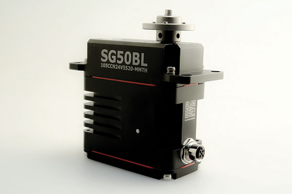
The SG50BL, designed with robust steel gears and a high-performance brushless motor, is capable of operating at a voltage range of 18 to 32 volts, the company said.
The actuator features a programmable digital circuit with a MOSFET amplifier; a BLDC motor; a magnetic encoder position sensor; five hardened steel gears low gear backlash (less than .5°); four ball bearing supported output shaft; nine needle bearing supported idlers; rugged anodized aluminum alloy case; and an IP68 waterproof rating.
The SG50BL also is capable of 360° proportional rotation and boasts T4131012051-000 TE connectivity. It includes CAN 2.0 A/B or UAVCAN control options, customization and modification options, and custom connector options.
Founded in 1973, Hitec designs and produces high quality actuators and radio control components for a variety of applications and demands.
A link to the live event will be sent to you two hours before the event. Your personalized event URL will be automatically generated by the ON24 system. To ensure receipt of the email, please whitelist this email address by adding it to your contacts: [email protected].
This presentation will begin at 1 p.m. Eastern / 10 a.m. Pacific / 7 p.m. Central European Time on Thursday, March 25th. A recording will also be sent to you the following day so you can watch it on-demand.
Audience members may arrive 15 minutes prior to live time. If you have any questions, please contact event producer Grace Rybak at [email protected]
The GPS Innovation Alliance (GPSIA) sent a letter on Feb. 16 to the White House National Economic Council, asking it solve the issues with Ligado interfering with GPS spectrum.
“Strong and unified leadership by the U.S. government is needed to preserve and advance GPS — leadership that recognizes the inherently unique functional and technical attributes of GPS,” wrote J. David Grossman, GPSIA executive director, in the letter.
Panel on risks to sat services
GPSIA’s J. David Grossman will be speaking Feb. 17 at 2 p.m. ET, in a panel discussion entitled “Satellite-Based Services at Risk?” Other speakers include former FCC Commissioner Robert McDowell; Capt. Steve Jangelis, representing the Air Line Pilots Association (ALPA); and Susan Avery, former president of the Woods Hole Oceanographic Institution. Register here.
The coalition, which counts Garmin, Apple and John Deere among its members, was ensnared in the dispute between Trump executive branch agencies and the Federal Communications Commission (FCC) over whether the commission’s Ligado approval decision in 2020 would affect GPS.
In the letter to NEC Director Brian Deese, the group argues that these squabbles “are not unique to GPS” and “reflect a continued pattern by which shared decision-making is replaced by the FCC acting with exclusive authority as the final arbiter.”
GPSIA recommends that the council
update a memorandum of understanding between the FCC and Commerce Department to help ease decision-making;
install a detailee from federal agencies managing GPS in the FCC’s engineering office; and
have each FCC commissioner add a technical adviser to its staff.
The letter concludes, “GPSIA and its members stand ready to be a resource to the NEC and others in the Administration seeking to more efficiently allocate spectrum, while protecting critical incumbent systems and services.”
French ministry for Armed Forces selects Airbus Survey Copter Aliaca fixed-wing drone systems to equip its ships
Airbus Defence and Space mini UAS subsidiary Survey Copter signed a contract with French DGA Armament general directorate to provide the French Navy with 11 systems, (22 aircraft), of the electrically powered fixed-wing Aliaca maritime version UAS (officially called SMDM / “Systèmes de Mini Drones aériens embarqués pour la Marine” by French authorities), including training and integrated logistic support. First deliveries are expected in 2021.
“We are honored to contribute to the missions of the French Navy which we will support with the highest standards of quality and reliability,” said Nicolas Askamp, head of Survey Copter/Airbus Unmanned Aerial Systems. “This new contract strengthens Survey Copter’s position as a global key player for maritime mini UAS.”
The Aliaca maritime UAS is a high-endurance versatile system allowing up to 3 hours missions over a 50 km (27 Nm) range, perfectly adapted to maritime missions with high gyro stabilized EO/IR payload performances and qualified to operate in severe environmental conditions.
The Aliaca SMDM is catapulted from a ship deck. (Photo: Airbus Defence and Space)
Launched by catapult, the Aliaca maritime UAS concludes its flight by landing automatically using a dedicated net landing solution. With a length of 2,2m and a wingspan of 3,6m for a maximum take-off weight of 16 kg., the Aliaca maritime UAS benefits from a powerful yet silent electric motor. The system can be deployed easily and rapidly in less than 15 minutes by 2 operators only.
Similarly, the user-friendly ground control station enables the operator to constantly monitor the automatic flight of the UAS while receiving in real-time day and night images and AIS (Automatic Identification System) data gathered by its on-board sensors.
It is designed to conduct several types of missions around the ships, including increasing the understanding of the tactical situation, control of illegal operations at sea, search-and-rescue, traffic monitoring, pollution detection, tracking of any suspicious behavior in the ship environment and coastal surveillance.
This light on-board aerial solution gives the opportunity to vessels, traditionally not equipped with aerial assets, to enhance their tactical ISR capabilities, support decision making and reactivity in operations.
The Aliaca maritime UAS can easily be integrated on board any ships, with or without helicopter landing-deck, and its small logistic footprint enables operations and storage on board smaller sized ships. Its integration does not require heavy on-board modification nor storage of specific fuel.
The result of 10 years of R&D investments and on-board experimentations, SURVEY Copter’s off-the-shelf Aliaca maritime UAS is a robust and resistant system to the corrosive maritime environment, an adapted solution to the electromagnetic constraints on board, and benefits from an efficient net recovery system, fully automated, meaning that no human action is required during the recovery phase.
The May virtual conference will feature live keynotes and education, interactive roundtable discussions and networking sessions. It also will include exhibits from leading technology companies and service providers. All sessions will be recorded and made available on-demand to attendees for 90 days following the event.
The August in-person event will feature a new program of keynote speakers and educational sessions, safely facilitated networking opportunities, and an expanded exhibit hall to experience the latest technology innovations and solutions.
The theme of Xponential 2021 is “Assured Autonomy,” which refers to the process, methodology and guiding principles for ensuring unmanned and autonomous systems will be safe and practical options, able to repeatedly perform the operations they are designed for and be seamlessly integrated into society at scale. According to AUVSI, this theme supports the event’s legacy of convening experts across markets and domains to advance the market for all things unmanned.
“As the global stage for all things unmanned, AUVSI Xponential 2021 is where you’ll join a community of end users, technologists and policymakers working together to fulfill this vision,” AUVSI said. “The series will support its mission to convene the unmanned and automated systems community to accelerate innovation and market adoption of the related technologies.”
AUVSI is a non-profit organization dedicated to the advancement of unmanned systems and robotics. It represents corporations and professionals from more than 60 countries involved in industry, government and academia. AUVSI members work in the defense, civil and commercial markets.
Check out GPS World‘s coverage of AUVSI Xponential from 2015, 2016, 2017, 2018 and 2019.
A roundup of recent products in the GNSS and inertial positioning industry from the February 2021 issue of GPS World magazine.
OEM
Development kit
Allows engineers to evaluate GNSS/INS module
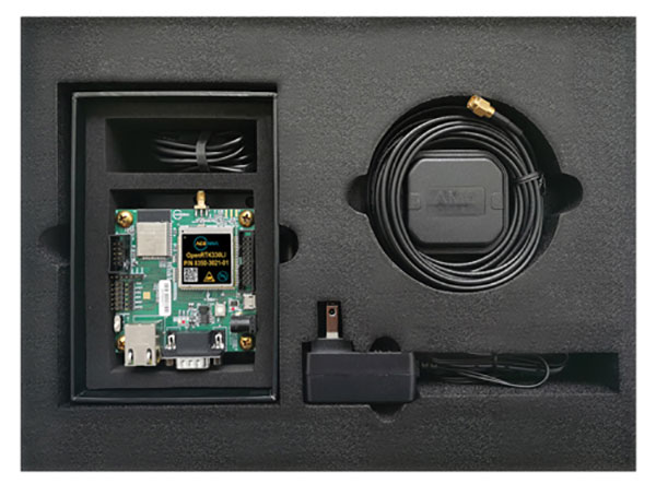
Photo: Aceinna
The Aceinna OpenRTK330LI EVK is a complete evaluation and development kit for the OpenRTK330LI GNSS/INS module. The kit accelerates development and reduces time to market of custom navigation and guidance systems fusing inertial measurements and multi-band RTK/GNSS positioning. It provides the essential hardware, firmware and development environment that engineers working on autonomous applications need to quickly start developing algorithms and solutions, allowing engineers to log and visualize positioning data with centimeter precision.
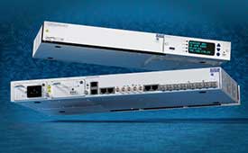
The OSA 5412 and 5422 are edge and access network synchronization devices with enhanced capabilities for next-generation applications such as 5G. The Oscilloquartz solutions address key challenges for a wide range of industries by bringing new levels of timing accuracy and resilience to edge networks. Both models provide in-service sync probing and assurance as well as innovative GNSS assurance capabilities. The devices also eight field-upgradeable, 10-gigabits-per-second ports, ensuring the scale and efficiency needed for next-generation smart grids, industrial internet of things (IoT) applications and 5G connectivity.
The AirgainConnect AC-HPUE 6-in-1 is a rugged outdoor mobile antenna with integrated modem, designed to meet the most demanding LTE connectivity needs of public safety and fleet vehicles. AC-HPUE provides two or three high-gain multi-band LTE antennas and one-band 14 LTE antenna powered by an HPUE LTE modem. The AC-HPUE supports an active GNSS element as well as two or three high-gain tri-band Wi-Fi antennas, including the new 6 GHz ISM band for Wi-Fi 6E (802.11ax), inside a single robust and compact housing. AC-HPUE attaches to the router WAN port via Ethernet data cable or directly to a laptop via USB cable. Wi-Fi and GNSS antennas connect to the router, meaning the router can be seamlessly used for Wi-Fi, location-based services, and managed using existing network management systems.
Amazon Monitron provides customers with an end-to-end machine monitoring solution comprised of sensors, gateway and machine learning service to detect abnormal equipment conditions that may require maintenance. Monitron is one of five new machine learning services that help industrial and manufacturing customers embed intelligence in their production processes to improve operational efficiency, quality control, security and workplace safety. The services combine sophisticated machine learning, sensor analysis and computer vision capabilities to address technical challenges faced by industrial customers. The other four services are Amazon Lookout for Equipment, the AWS Panorama Appliance, the AWS Panorama SDK and Amazon Lookout for Vision.
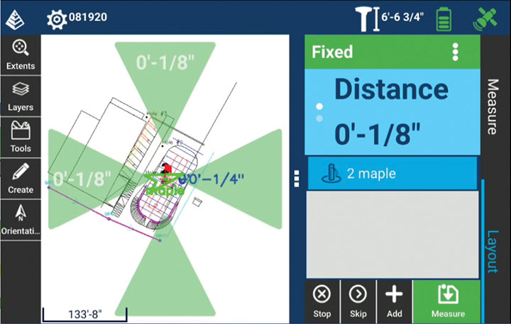
Carlson Layout allows fast, efficient layout capabilities for construction professionals using total stations or GPS receivers such as the Carlson CR+ series of robotic total stations and the Carlson BRx7 GNSS receiver. Included are the full Carlson driver library and a range of compatible hardware options. Features include an intuitive user experience, support for DXF and DWG files, integration with Google Drive and other cloud storage, compatibility with Carlson CRD and CRDB files, and the ability to check surface or fixed elevations without creating points. It also includes simple layout for points, lines and surfaces. Layout works with GPS real-time kinematic (RTK) systems and can receive RTK connections from a cellphone, internal modem, internal radio or external radio.
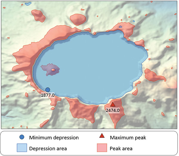
Surfer is a gridding, contouring and 3D surface-mapping package. The latest version offers a greater number of options for displaying scientific data. New display options enable users to more easily communicate the information extracted from their data. The Surfer package is used by professionals in oil and gas exploration, environmental consulting, mining, engineering and geospatial projects to easily visualize and interpret complex data sets. Surfer enables users to model data sets, apply an array of advanced analytics tools, and graphically communicate the results. Features include a new peaks and depressions layer type for mapping geohazards or drainage patterns in karst topographies.
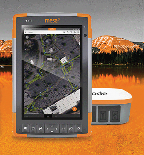
Uinta’s data collection tools include detailed mapping with points, lines, areas and form-based notes for digital recordkeeping. Customization options allow organizations to create templates that better align with the type of data they are mapping and recording. Templates can be shared among users, and Juniper Systems has many templates for various industries and use cases. Users can export data to a file, print professional PDF map reports, and create optional cloud projects. Combined with a Mesa 3 Rugged Tablet running Windows 10 and a Geode Sub-meter GPS Receiver, Uinta offers a rugged, robust and powerful data collection solution. Industries using Uinta include utility mapping, government asset management and mapping, industrial assets, irrigation, and sectors within natural resources.
The FLY-R R2-150 has a top speed of 200 km/h (124 mph). Currently in functioning prototype form, the battery-powered R2-150 is designed for such tasks as fully autonomous surveillance, observation and reconnaissance. It has a wingspan of 1.5 meters (4.9 feet), a cruising speed of 115 km/h (71 mph), and can fly for up to two hours per charge while transmitting real-time video. It can automatically take off from a ship- or truck-mounted vacuum launcher and land in a recovery net. Another model, the jet-powered R2-HSTD, is expected to have a top speed of Mach 0.65 (803 km/h or 499 mph) and is intended to serve as a target drone for military exercises. FLY-R’s aircraft incorporate a rhomboidal wing design, which reduces wingspan by half and reduces aerodynamic drag.
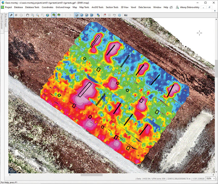
The drone-integrated metal detection system uses an airborne modification of the Geonics EM61-MK2 ground metal detector. The EM61 Lite airborne variant integrates with the UgCS SkyHub onboard computer and ground control station. Features include automatic data logging in geotagged form and automatic terrain following with radar altimeter. The use of UgCS SkyHub enables the drone to fly in true terrain following mode with the help of the radar altimeter and to log geotagged sensor data. An optional RTK/PPK GNSS receiver on the drone will geotag the data with centimeter-level precision. The integrated system has been extensively tested at SPH Engineering’s test range, and has shown excellent performance and repeatability for targets such as pipes (steel, stainless steel, reinforced concrete) and steel drums. Applications include unexploded ordnance (UXO) search, detection of underground infrastructure and archaeology.
“Seen & Heard” is a monthly feature of GPS World magazine, traveling the world to capture interesting and unusual news stories involving the GNSS/PNT industry.
The city of Prague started testing a system of GNSS repeaters to prevent the loss of satellite signal in the city’s tunnels. The system, which should make life easier for drivers who rely on car navigation technology, is being tested in Prague’s Blanka tunnel. If it proves successful, the municipality wants to install the devices in other strategic locations around the city, especially at intersections as well as tunnel entries and exits.
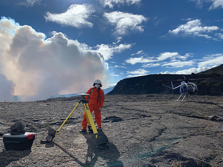
Photo: A. Ellis/USGS
On the hot spot
While permanent monitoring receivers are scattered about Hawaii’s active volcano sites, additional GPS receivers are being deployed during the ongoing eruption of Kilauea. In this photo taken Dec. 21, 2020, a Hawaiian Volcano Observatory geophysicist deploys receivers on the caldera floor in Hawai‘i Volcanoes National Park to measure changes in ground motion. The gas plume from the summit eruption within Halema‘uma‘u crater is visible in the background.
Photo: Ishaqbini Community Conservancy
Last but not least
The last white giraffe known in existence now sports a GPS tracker, reports BBC News. The male giraffe has a rare genetic trait called leucism that causes the unusual color. The giraffe was tranquilized in November and the tracker placed on one of its horns. Tracking will help protect it from poachers as it grazes in Kenya’s savannah near the Somalia border. The white giraffe is alone after a female and her calf were killed by poachers in March 2020, according to Ishaqbini Hirola Community Conservancy.
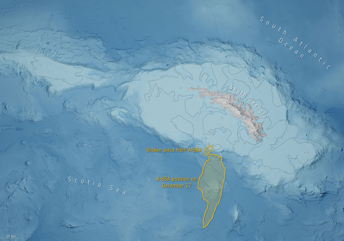
Photo: British Antarctic Survey/ESA
The biggest loser
In July 2017, an iceberg more than twice the size of Luxembourg broke off Antarctica’s Larsen C ice shelf and began traveling the Southern Ocean. Looming in its path is South Georgia Island, home to numerous species of wildlife threatened by the massive iceberg, designated A-68A. Europe’s Copernicus Sentinel satellites observed pieces breaking off of A-68A in December, each large enough to receive its own designation.
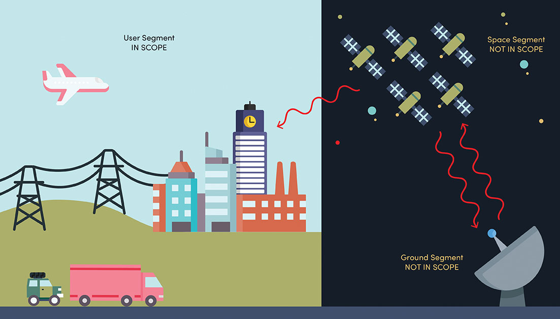
NIST’s new cybersecurity profile is designed to help mitigate risks to systems that use PNT data, including finance, transportation, energy and other critical infrastructure. While its scope does not include ground- or space-based PNT source signal generators and providers (such as satellites), the profile still covers a wide swath of technologies. (Image: B. Hayes/NIST)
The National Institute of Standards and Technology (NIST) has drafted guidelines for applying its Cybersecurity Framework to critical technologies such as GPS that use positioning, navigation and timing (PNT) data. Part of a larger NIST effort to safeguard systems that rely on PNT data, these cybersecurity guidelines accompany NIST efforts to provide and test a resilient timekeeping signal that is independent of GPS.
Formally titled the “Cybersecurity Profile for the Responsible Use of Positioning, Navigation and Timing (PNT) Services (NISTIR 8323),” the new guidelines are designed to help mitigate cybersecurity risks that endanger systems important to national and economic security, including those that underpin modern finance, transportation, energy and additional economic sectors.
The draft profile is part of NIST’s response to the Feb. 12, 2020, Executive Order on PNT. In early 2020, NIST sought public input regarding the general use of PNT data. The PNT profile will join the growing list of profiles created to help apply the NIST Cybersecurity Framework to particular economic sectors, such as manufacturing, the power grid and the maritime industry. The scope of the profile includes any system, network or other asset that uses PNT services, including systems that receive and rebroadcast PNT data.
While its scope does not include ground- or space-based source PNT signal generators and providers (such as satellites), the profile still covers a wide swath of technologies. Partly for this reason, NIST’s Jim McCarthy said that it is intended to be a foundational set of guidelines that PNT users can customize.
“The profile is meant to help a broad set of users address their cybersecurity needs,” said McCarthy, one of the draft’s authors. “Rather than focus on a single economic sector, we designed it to apply to all users of PNT. Agencies and companies can tailor it to their needs based on their particular cybersecurity risk and other sector-specific factors.”
As directed by the Executive Order, the profile can help organizations accomplish four tasks:
identify systems that use PNT data, and/or that propagate this data based on a source signal
identify PNT data sources, such as a GPS signal
detect disturbance to and manipulation of systems that use PNT services
manage the risks that come with responsible use of these PNT services
“Our premise is that there are organizations that may not realize they are using PNT data, or know how they are using it,” McCarthy said. “Part of our goal is to help them make these connections so they can protect their operations more effectively.”
The Executive Order also delegates to the Department of Commerce the critical task of providing a source of Coordinated Universal Time (UTC) that is independent of GPS. To this end, NIST also recently conducted initial tests of a special calibration service for companies, utilities or other organizations that wish to receive NIST’s version of the global time standard, UTC(NIST), through commercial fiber-optic cable.
The service aims to provide a time reference directly traceable to UTC(NIST) with an accuracy of 1 microsecond — good enough for telecom networks, the power grid and financial markets, and thereby boosting the resilience of accurate time distribution and the infrastructure sectors and subsectors that use timing services.
The initial link is a collaboration between NIST and OPNT, a commercial time-service provider based in Amsterdam, the Netherlands. While the work was led by researchers at NIST’s Boulder, Colorado, campus, the dedicated optical fiber connects the reference time scale at NIST headquarters in Gaithersburg, Maryland, to a facility in McLean, Virginia, that will ultimately serve as the hub for East Coast distribution of timing data.
OPNT has extended the initial fiber link to Atlanta, Georgia, about 800 kilometers from McLean. Preliminary data suggest that this link will be able to support the requirements of the Executive Order.
“Seen & Heard” is a monthly feature of GPS World magazine, traveling the world to capture interesting and unusual news stories involving the GNSS/PNT industry.
Lost and found
Taking video from an airplane window 300 feet up carries its share of risks, discovered Brazilian documentary filmmaker Ernesto Galiotto. The bad news: A strong wind snatched his iPhone 6 from his hand. The good news: GPS enabled him to recover the phone, which suffered only a minor crack in its protective cover. The best news: The phone captured the entire 15-second drop on video. The incident happened over Peró beach 75 miles east of Rio de Janeiro, reported Brazilian news outlet G1.
Photo: Land Life Company via Trimble
Finding particular trees in the forest
Locating and documenting a single tree in a forest planting can be difficult. Technicians at Land Life, an Amsterdam-based land restoration company, have switched from using QR codes and readers for tree identification to GNSS. By replacing the QR codes with accurate GNSS positioning, Land Life produced a four-fold increase in monitoring productivity. The company measures sapling height and health and combines that data with tree species, location, soils and environmental conditions to support planning and care. Field teams now use a Trimble R1 GNSS receiver to stream positioning data via Bluetooth to their smartphones.
Screenshot from video of Escoffier’s rescue/VendéeGlobe
Answering an SOS
Yacht skipper Kevin Escoffier faced disaster during the Vendée Globe solo round-the-world sailing race. His yacht was pounded apart in raging seas 840 nautical miles southwest of Cape Town, South Africa. Once his raft hit the water, its rescue beacon activated. Through the Cospas-Sarsat service, the signal moved from Galileo satellites to ground stations in Toulouse, France, to Canberra, Australia, then to race directors, who sent the closest competitor to assist.
India will be free of toll booths in two years, said Nitin Gadkar, the country’s transportation minister. According to the Times of India, the government will roll out GPS-based tolling across its national highway sytem. Tolls will be deducted directly from drivers’ bank accounts based on distance traveled. While commercial vehicles registered after January 2019 have tracking systems, the government has yet to outline plans to install GPS receivers in older private vehicles.
A roundup of recent products in the GNSS and inertial positioning industry from the January 2021 issue of GPS World magazine.
OEM
Receiver board
Enhanced with corrections
Photo: Septentrio
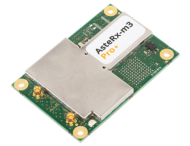
The AsteRx-m3 Sx OEM board dual-antenna receiver combines Septentrio’s latest core GNSS technology with the SECORX-S sub-decimeter correction service to enable plug-and-play positioning. High-accuracy positioning is available directly out of the box, GNSS corrections automatically streamed to the receiver. This significantly simplifies the set-up process and eliminates the need for corrections service subscription and maintenance. Corrections are delivered via internet or L-band satellites, ensuring sub-decimeter service even in remote locations where there is no easy internet access.
The new TW5382 smart GNSS antenna is designed for high-accuracy 5G timing. The TW5382 is a multi-band, multi-constellation 5G smart GNSS antenna/receiver that provides 5 ns (1-sigma, clear sky view) timing accuracy. It consists of two components: a Tallysman GNSS Accutenna technology antenna and a professional-grade GNSS timing receiver module. Accutenna supports the full bandwidth of the TW5382 receiver, strong multipath mitigation and deep filtering in a compact IP69K enclosure. These features enable the antenna to provide a strong, pure, in-band, right-hand circular polarized signal to the receiver. The TW5382’s professional-grade multi-constellation and multi-signal timing receiver tracks GPS/QZSS (L1/L2), GLONASS (G1/G2), Galileo (E1/E5b), and BeiDou (B1/B2) signals.
The new Precision GNSS Module (PGM) is designed to offer fast evaluation and a quick path to production for those requiring a precise positioning solution. It is available in a simple-to-use, industry-standard mPCIe (mini peripheral component interconnect express) format and is designed specifically for Swift’s Starling positioning engine running on a host application processor to deliver real-time precision navigation. The PGM utilizes STMicroelectronics’ TeseoV chipset in Quectel’s multi-constellation, dual-band LG69T-AP receiver to create an affordable, easy-to-use solution for customers building industrial, last-mile and internet of things (IoT) platforms. This solution operates with the highest accuracy when used with Swift’s Skylark positioning service.
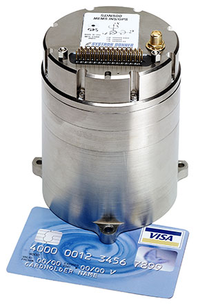
CAST Navigation tested Emcore’s SDN500 inertial navigation system (INS) in an ultra-high-altitude flight simulation and achieved success. The test required simulating performance at an altitude of more than 24,000 meters and velocities over 600 m/s. Only a few aircraft in the world have such capabilities, including the SR-71 Blackbird, but it is not practical to participate in a test flight on the SR-71. Simulating the SDN500 INS test flight to specific customer profiles on a CAST system is straightforward and cost-effective. Emcore relies on GNSS/INS simulators for hardware-in-the-loop testing to verify the expected performance of algorithms. Emcore sought to validate the velocity and altitude limits of a new GNSS receiver along with the algorithm performance in a tactical-grade SDN500 system.
The Dimensity 700 5G smartphone chipset is a system on chip (SoC) designed to bring advanced 5G capabilities and experiences to the mass market. MediaTek’s Dimensity family of 5G chips is designed to give device makers a suite of options for 5G smartphone models. The chips range from flagship and premium to mid-range and mass market devices to make 5G more accessible for consumers everywhere. GNSS signals received include GPS L1CA and L5, BeiDou B1I and B2, GLONASS L1OF, Galileo E1 and E5, QZSS L1C and L5, and NavIC.
IHawk allows users to inspect sites remotely and then download and view the analysis anywhere in the world. It eliminates the need for engineers to climb towers for inspections or work in hazardous environments. The imagery and information gathered provides a detailed and highly accurate analysis of the condition of power transmission towers.
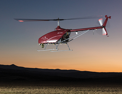
The Alpin UAS is a long-range, heavy-lift unmanned helicopter capable of carrying up to 160 kg with a range of up to 840 km. The UAS includes a wideband satellite communication channel from its command-and-control station — a valuable feature, particularly for operations in remote areas. The Alpin unmanned helicopter is able to withstand severe weather conditions, carry multiple payloads, and transmit real-time information to defense forces and decision-makers in the field. Its system autopilot has features and advantages such as fully autonomous take-off and landing, remote ground-control network capability, auto-rotation landing capability and high efficiency flight control based on a total energy control system (TECS).
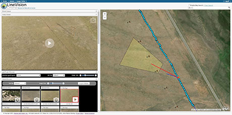
LineVision Online now provides enhanced support for visualizing and mapping DJI drone video camera metadata and field-of-view projections. The secure web application is designed for immersive mapping, analysis, search, sharing and archive of geo-referenced videos, full-motion video, photos and other survey, inspection and surveillance datasets. With enhanced camera metadata mapping in LineVision Online, DJI drone videos can now display a dynamic, field-of-view outline representing where the gimbal camera was looking on the Earth as the video plays in the web-based map interface. Users can select any point along the UAV’s flight track on the map to immediately cue the video to play what was recorded at that location click point.
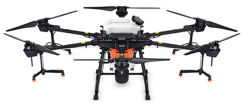
The Agras T20 drone can conduct autonomous operations over a variety of terrains, such as broad-acre farmlands, terraces and orchards. As a comprehensive spraying system, the T20 allows users to easily set flight and operation parameters. With a built-in real-time kinematic (RTK) centimeter-level positioning system and RTK dongles, centimeter-level waypoint recording is enabled, strengthening operations and ensuring precision spraying.The T20 is equipped with eight nozzles and high-volume pumps that can spray at a rate of up to 6 liters per minute. A highly optimized wind field produces droplets of the correct size and consistency. The T20 is also equipped with a new four-channel electromagnetic flow meter, which monitors and controls four hoses individually, ensuring an efficient flow rate for each nozzle.
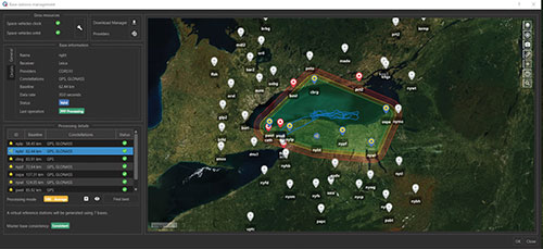
A new virtual base station (VBS) feature is available in Qinertia, GNSS and inertial navigation system (INS) post-processing software. Trajectory and orientation are greatly improved by processing inertial data and raw GNSS observables in forward and backward directions. The VBS computes a virtual network around a project in which position accuracy is maximized, homogeneous and robust, such as a PPK short baseline. Once surveyors collect data, Qinertia chooses the most relevant reference stations, builds a virtual network and brings the project to centimeter-level accuracy with no convergence effects, even in urban areas.
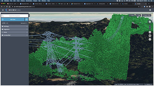
Enview Explore is a powerful web application that leverages artificial intelligence and cloud computing to automatically process 3D data at a high speed and scale. Enview performs a variety of geospatial operations, including object recognition, feature extraction, feature-based change detection, and 2D/3D measurement. Enview’s technology has been deployed on thousands of square miles worldwide to protect vital infrastructure and support mission-critical operations. Its unique method for classifying 3D data reduces time to action by focusing on finding meaningful insights.
PDGrade — a machine guidance and positioning system that uses GNSS for pile driving applications — is now optimized for the solar industry with an increased capability in pile installation and navigation accuracy. It removes the need for surveying piles and reviewing as-built information by centralizing all relevant information and providing necessary details to operators and site supervisors.The system features both software and hardware applications to provide operators with detailed information such as pile navigation, pile location, positioning and height information, project progression tracking, and detailed accuracy. The PD machine is fitted with Carlson sensors and a ruggedized Windows-based MC10 tablet. The entire system is then calibrated within PDGrade.
TCarta Marine has introduced a Global Satellite Derived Bathymetry (G-SDB) product line developed with a new seafloor depth measurement technique that leverages Machine Learning and NASA ICESat-2 laser data. According to the company, this G-SDB offering covers the entire Red Sea, with additional sets rolled out through the end of this year.
The commercial TCarta G-SDB data sets and the seafloor measurement workflow that produces them were made possible through a Small Business Innovation Research Grant from the National Science Foundation (NSF).
According to TCarta, G-SDB data sets contain bathymetric measurements to depths of more than 30 meters, depending on water clarity, at 10-meter resolution. The depth values for every 10-meter pixel are the combined result of numerous measurements, resulting in accuracy within 10% of depth or less, and providing a seamless water bottom surface map. G-SDB will be available globally for all oceans and seas, as well as large freshwater lakes where water conditions permit.
“The new satellite-derived bathymetry technology extracts seafloor measurements by integrating multiple SDB algorithms and sensor types at scale and over broad geographic areas with a degree of confidence in data accuracy not previously possible,” said TCarta president Kyle Goodrich.
TCarta launched Project Trident with NSF funding in 2018 with the goal of refining traditional satellite-derived bathymetry technology to extend its application into areas where it had not typically been successful, usually due to the turbidity or clarity of the water column. TCarta developed the new method using machine learning to iteratively evaluate Sentinel 2A/B multispectral satellite images, and even individual pixels within images, to select the sharpest and clearest ones for application of SDB extraction.
“Thanks to the power and speed of cloud computing, we run the extraction algorithm repeatedly and on multiple satellite images acquired over the same geographic area on different dates. This dramatically increased the accuracy confidence in each depth measurement and minimizes data gaps,” Goodrich said.
To further enhance the accuracy of the SDB measurements, TCarta developed an artificial intelligence-based technique for leveraging ICESat-2 data to train the SDB algorithm and validate results. Designed for polar ice elevation and tree canopy measurements, the ICESat-2 satellite carries a laser that captures remarkably accurate bathymetric data, the company said.
TCarta Marine is a global provider of hydrospatial solutions. The TCarta product lines include high-resolution satellite-derived water depth and seafloor map products as well as 90- and 30-meter GIS-ready bathymetric data aggregated from numerous information sources.
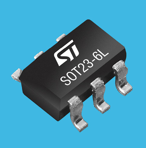
STMicroelectronics’ latest RF front-end for GNSS receivers offers a simplified design and smaller footprint. The BPF8089-01SC6 integrates the impedance-matching and electrostatic discharge (ESD) protection circuitry typically implemented using discrete components.
The BPF8089-01SC6 provides a 50-ohm matched interface between the receiver’s antenna and low-noise amplifier (LNA), and is ready for plug-and-play with the company’s STA8089 and STA8090 LNAs.
The BPF8089-01SC6 is suitable for use in portable receivers for the GPS, Galileo, GLONASS, BeiDou and QZSS constellations, which can be used in applications such as consumer satellite navigation, radio base stations, drones and tracking of assets or livestock.
The BPF8089-01SC6’s compact, integrated front-end can replace a matching network containing up to five capacitors, resistors and inductors, as well as two discrete protection devices, resulting in a much smaller footprint. Designers can also leverage PCB-track specifications provided in the device datasheet to ease design challenges and ensure optimal performance.
The ESD protection provided complies with IEC 61000-4-2 (C = 150 pF, R = 330 ohm) and exceeds level 4: 8 kV for contact discharge and 15 kV for air discharge. The device also withstands 2 kV pulse voltage in accordance with MIL-STD 883 C (C = 100 pF, R = 1.5k ohm).
Part of ST’s Application Specific Integrated Passives (ASIP) product range, the BPF8089-01SC6 is housed in a SOT23-6L package compatible with automatic optical inspection.