Those attending Intergeo 2021 will have the option to attend either virtual or in person. The show will be taking place Sept. 21-23 in Hanover, Germany.
According to show organizers, their most important concerns are a guarantee of implementation, the best possible planning and security for exhibitors, their employees and their customers.
“A clearly defined hybrid concept ensures from the outset that you will be able to reach your customers and markets with the Intergeo platform under all conceivable conditions without taking any risks,” show organizers said in a press release. “According to much feedback from Intergeo partners, enabling personal exchange live and digitally scalable offers the greatest possible acceptance.”
Show organizers also said the event will feature a generous, hygienic and modularized layout.
“Both a well thought-out hygiene-compliant and modularized hall plan in the spacious exhibition center in Hanover and a targeted further development of the digital platform will provide the geo-community with a valuable and future-oriented opportunity for dialog,” they said.
The main topics covered at Intergeo 2021 will include drones (imperial solutions), smart city solutions and BIM for infrastructure.
We leave as we came, and, God willing, we shall return, with peace and hope for all mankind.” —Astronaut Gene Cernan’s closing words, the twelfth and last person on the moon as he stepped back into the Apollo XVII Lunar Module on December 13, 1972.
Photo: NASA
Apollo was about vision, courage and discovery. Apollo helped unravel the mysteries of the moon — a serene, desolate, and barren place, bleached by the sun, and covered in a pale, gray, abrasive dust made up of microscopic, razor sharp, glass-like shards called regolith that is 60 feet deep in places.
Beneath the regolith is the bedrock of the moon — the Lunafirma.
The next phase of exploration is building a permanent base station on the moon, aptly named Artemis, Apollo’s twin sister. It would be fitting when mankind returns that the next person who steps out onto the lunar surface were a woman.
Artemis Moon Log/Program Entry Date 42: Earth Day is Tuesday, November 4, 2025
The regolith mining operations are proceeding as expected. All operations are 100% solar power until additional mobile thorium reactor units arrive. The only existing thorium reactor unit is the Clavius Crater water extraction operation. Construction of the Selene-1 Moonbase has encountered a setback. No other issues are reported.
The regolith in the surrounding plain is 6 meters deep. The Miners have not experienced any issues. The electrostatic power suits are repelling the abrasive dust better than expected. The Miners have cleared a 50 m2 area down to the bedrock. From the Gateway observation deck, it appears as a small square crater. The Miners are working non-stop on rotating shifts clearing regolith, recharging, replacing parts, or in transit.
Analysis of the regolith reveals a uniform distribution of 21% silica, 13% aluminum, 10% calcium, 10% iron, 5% magnesium, and 2% sodium and titanium. Minor amounts of chromium, phosphorus, and potassium are present. Hydrogen is 0.0027%. The metals are all oxides containing 40% elemental oxygen, which is being separated during processing for later use.
West about 200 km, towards Mare Crisium, the gravitational anomalies increase but within the Selene-1 Moonbase crater the anomalies are negligible. Geospatial analysis of the drill cores show an extensive concentration of lithium beneath a 12-meter-thick layer of basalt east of Ginzel Crater. Towards the south are increased concentrations of titanium and tungsten. Ejection debris discovered during the regolith mining operation showed traces of neodymium. The estimated trajectory of the ejecta points to it coming from the Moiseev Crater complex. An expeditionary rover is in route to collect samples and will arrive in 6 hours. Readings from those samples will be in the next log report.
The Parabolic Solar Powered (PSP) laser torches in the open crater basin are performing as expected. The Constructors are 3D fusing the regolith into silicate glass forms and transporting them to staging areas for later construction. The higher-than-normal content of iron in the regolith is giving the glass forms a reddish hue.
At the south pole, the water extraction operation at Clavius Crater has been operating uninterrupted for 816 hours. The thorium reactor is powering the entire operation. The smelter is distilling volatiles out of the regolith at the rate of 1m3 every 8 hours extracting a liter of water every 24 hours. The operation is on schedule for the two 100-liter tanks of water for delivery to the Selene-1 Moonbase by the due date.
There are five 4G cellular towers around the perimeter of the Selene-1 Moonbase and regolith mining area at 3 km intervals. The cellular array is providing accuracies of 1 millimeter allowing for precision mining, drilling, construction, and transportation. As the operation expands, more towers will be added. Two more towers are stationed at Clavius Crater. The 360° cameras and radar provide continuous surveillance and monitoring.
Testing of the 3D vision and synthetic neural response systems of the robots is complete and all of them are operational. The real-time connectivity with the robots allows controllers onboard the Gateway to remote link into any of the robots using virtual headsets and haptic body suits for full-immersion control. AI is constantly scanning for anything unusual and alerts the controllers to remote in; otherwise, the robots operate continuously and efficiently. The Miners are clearing nearly 5m3 of regolith every 24 hours during light conditions.
Phase I is underway. Miners are leveling off the exposed bedrock to begin construction of the landing pad. Once finished, the Constructors will use the PSP laser torches to begin fusing together the silicate glass blocks to make the landing pad. Afterwards, The Miners will begin Phase II and lay the foundation for the railgun to propel the filled mineral containers back to Earth. Both Phase I and Phase II are on schedule.
The setback encountered during construction of the Selene-1 main base station is due to excessive heat build-up. The Excavators are clearing the floors and shaping the walls within the lava tube. However, the heat from the laser torches is building-up and shutting down the machines prematurely. When the ambient temperatures exceed 160°C the machines shutdown to protect their electrostatic coatings. Having no atmosphere and no wind the heat is not dissipating. The fluid in the heat exchangers is overheating. Until directed otherwise, the Excavators are doing 90-minute shifts and the Torches for 35 minutes. The Torches have to fuse together the support beams and the silicate glass protective layering behind the Excavators to preserve structural integrity. A software update set the laser torches to pulse fire extending the heat build-up for an additional 5 minutes. Only 15 meters have been cleared but the inflatable habitats require at least another 85 meters into the lava tube. The setback pushes back the date for completing the base station by approximately 620 hours. A temporary external module can house the astronauts for their return on April 19, 2026 until Selene-1 is completed.
The above fictional account of a Moon Log entry for the Artemis program is based on NASA’s mid-October announcement selecting Nokia to build a 4G network on the moon.
An in-depth look at the announcement holds interest for the GIS community.
The Artemis program will be heavily dependent on spatial technologies and require a Lunar Spatial Reference System. However, the Moon has significant challenges. There is no constellation of satellites orbiting the Moon to provide precise location data like GPS satellites do on Earth, and it is not possible to develop such a satellite system around the moon because the moon’s gravitational center is lopsided and weighted towards Earth due to tidal lock. This causes orbital decay of lunar satellites until they eventually crash into the lunar surface.
However, there are four orbital inclinations that allow for indefinite low orbits and may provide for a future Lunar Positioning System (LPS). Such a system would be extremely costly, so a less expensive and more immediate LPS will be a ground-based cellular network array; and 4G is preferred over 5G because it offers longer ranges, which is why NASA selected Nokia. NASA is working on other solutions through the Space Communications and Navigation (SCaN) program.
Figure 2: Unified Geologic Map of the Moon. Orthographic projections of the “Unified Geologic Map of the Moon” showing the geology of the Moon’s near side (left) and far side (right) with shaded topography from the Lunar Orbiter Laser Altimeter. It will serve as a reference for lunar science and future human missions to the moon. Gravitational mass concentrations are also depicted in the image showing the majority being on the nearside while the farside is void of gravitational concentrations. Check out a video of rotating sphere. (Image: NASA/GSFC/USGS)
In a blow to science fiction novels, it will not be humans out on the barren, dust covered lunar landscape, or in the cold depths of crater shadows with pickaxes and jackhammers. It will be robots working prolonged periods in extreme temperatures running on solar power or nuclear power while constantly bombarded by cosmic rays and direct solar radiation.
Accomplishing this will require real-time communication with spatially enabled, artificially intelligent machines able to support fully immersive experiences with 3D vision headsets and haptic feedback systems so controllers at the base station wearing special suits can remote into any robot.
Due to a 2.5-second transmission delay between the Earth and the Moon, Ground Control will be limited to observation and analysis. Autonomous rockets will ferry cargo and supplies between more distant locations on the moon and ferry astronauts back and forth to the Gateway space station.
The ground-based 4G cellular towers will be mobile units with retractable towers about 25 meters high with a circular array of solar panels that will unfurl about 10 meters up from the base of the mast to protect them from the abrasive regolith dust.
Beneath the panels rovers and robots will plug in and charge their batteries as they journey to and from the base station. The towers will have 360° cameras and sensors and will provide data links and a localized spatial reference system.
However, objects in flight, such as autonomous rockets, will require other means to navigate across the moon and between the space-based cargo ships and the base station.
One solution is visual-inertial odometry (VIO). It uses one or more cameras and at least one inertial measuring device. Those components are already standard on almost every smartphone. Position accuracy using VIO is derived by feature recognition — the most prominent features on the moon are craters.
In support of this initiative, the National Geospatial Intelligence Agency (NGA) is sponsoring a software developer’s challenge to create algorithms for identifying circular patterns in imagery. It’s harder than you think. Learn more here.
Figure 3. (Photo: NASA/GSFC/Arizona State University)
The base station will be inside a lava tube beneath the moon’s surface to protect astronauts and equipment from solar radiation and micrometeor impacts. Most of the resources for the moon base will be extracted and processed in-situ, which requires spatial analysis of drill core samples to pinpoint where to mine for minerals in the subsurface layers and where to locate scarce resources such as water. The lava tubes on the moon are also valuable for mining operations but navigating an underground environment with autonomous machines poses challenges of its own, some of which are spatial awareness. The Defense Advanced Research Projects Agency (DARPA) recently held a developer’s challenge to address navigating in subterranean domains.
“Reaching the Moon by three-man vessels in one long bound from Earth is like casting a thin thread across space. The main effort, in the coming decades, will be to strengthen this thread; to make it a cord, a cable, and, finally, a broad highway.” —Isaac Asimov
William Tewelow works for the Federal Aviation Administration. He is a graduate of the FAA management fellowship program. He served on special assignment to the U.S. Department of Transportation leading a national strategic geospatial iniative for the White House Open Data Partnership. He is a Geographic Information Systems Professional and a speaker for the Maryland STEMnet Scholar program. He was among the first in the nation to earn a Geospatial Specialist Certification from the U.S. Department of Labor while working at NASA Stennis Space Center. He has degrees in Geographic Information Technology, Intelligence Studies and is completing a masters degree in Organizational Management. William is a 23-year veteran for the U.S. Navy serving as a geospatial specialist, imagery intelligence specialist, a naval aviator, a meteorologist and a tactical oceanographer. He is married, enjoys writing and traveling. His favorite quote is, “A man’s mind changed by a new idea can never go back to its original dimension.” —Oliver Wendell Holmes
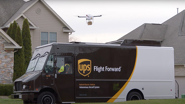
Skyward, a Verizon company, and UPS Flight Forward will collaborate to deliver retail products with drones connected to Verizon 4G LTE, as well as testing and integrating 5G for delivery.
“We will need the ability to manage and support multiple drones, flying simultaneously, dispatched from a centralized location, operating in a secure and safe environment,” said Carol B. Tomé, CEO of UPS. “To do this at scale, alongside Verizon and Skyward, we’ll need the power of 5G.”
“We’re just beginning to see how the power of 5G Ultra Wideband will transform the way businesses operate,” said Rima Qureshi, chief strategy officer at Verizon. “By partnering with UPS and other innovative companies, we can learn from each other’s expertise and collaborate to create solutions that help move the world forward.”
Photo: Verizon
In 2020, Verizon, UPS Flight Forward and Skyward started testing 4G LTE in delivery drones to demonstrate cellular reliability and performance at altitude.
“The low latency of 5G and edge compute is ideal for monitoring air traffic in and out of a busy logistics hub, especially those using mixed fleets of autonomous vehicles like drones, trucks and planes,” said Mariah Scott, Skyward President. “This year, we’ll be taking the collaboration with UPS further by testing 5G Ultra Wideband integrations to connect the sky.”
UPS has operated more than 3,800 successful drone delivery flights since the creation of UPS Flight Forward, its drone delivery company, certified by the Federal Aviation Administration in 2019. But in 2020, drone delivery emerged as much more than rapid delivery of essential healthcare items — during the global pandemic it provided high-risk seniors a rapid and contactless delivery option to remain healthy at home.
“Using Verizon’s 5G and Skyward, we’ll be able to transform the delivery experience — more personal, more on-demand and with the same safety, efficiency and reliability our customers trust today,” said Bala Ganesh, vice president, Advanced Technology Group at UPS.
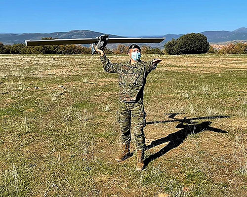
The Spanish Army and Navy have received the first Seeker Remotely Piloted Aircraft Systems (RPAS) from GMV and Aurea Avionics. The unmanned aircraft is designed to boost the intelligence, surveillance and reconnaissance capabilities of two elite forces, the Spanish Army’s 6th Almogávares Paratroopers Brigade and the Marine Infantry Protection Force.
Seeker has a 90-minute endurance and 15-km range, and weighs 3.5 kg. The UAV’s design and manufacture in Spain proved crucial during the COVID-19 epidemic, with the manufacture, test flights and delivery of the aircraft all performed within the project deadlines.
In the final phase of the project, intensive training courses took place on the Madrid site of Aurea Avionics and the Los Alijares Firing and Maneuvering Range (CMT) of Toledo. There, future Seeker users put the RPAS through its paces with mission simulations, engaged in vehicle-tracking exercises and learned about its theoretical and practical uses.
Seeker will provide BRIPAC (Paratrooper Brigade) and BRIMAR (Marine Infantry Brigade) with real-time thermal-infrared and visible-spectrum video, augmented by metadata that can be mined by the operators and remotely by the command-and-control centers.
New digitized ground-station architecture makes Seeker compatible with NATO’s standard command centers. This means any allied force will be able to integrate the aircraft into its fleet and command centers, ensuring joint operability between all troops and systems.
The RPAS is financed by the Subdirectorate General of Planning, Technology and Innovation of the Directorate General of Armaments and Material.
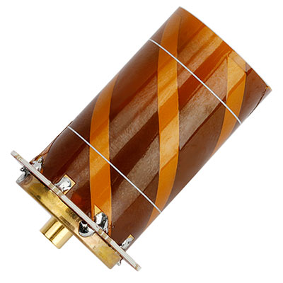
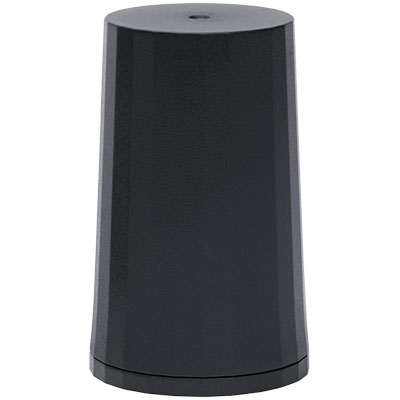
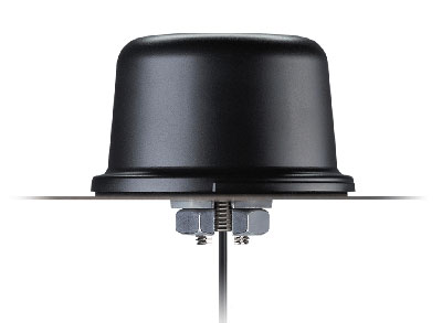
Tallysman Wireless has introduced two lightweight and compact active Iridium helical antennas designed to receive Iridium Satellite Time and Location (STL) signals.
The signals are used by STL terminals to provide worldwide position, navigation and timing independent of GPS/GNSS via an encrypted satellite broadcast signal that is strong and secure and can also be received indoors.
Because GNSS signals may be jammed (intentionally or accidentally) and spoofed, STL signals are a reliable alternative to augment and authenticate time for applications, such as electrical grids, wireless communications networks and financial systems, as well as position for private and public infrastructure.
The housed HC610 and embedded HC610E active Iridium antennas operate in receive-only mode and enable Iridium terminals to be installed tens of meters away from the antenna.
Photo: Tallysman
Both antennas are light and compact and feature a precision-tuned helical element that provides an excellent axial ratio and operates without a ground plane. They also feature a low-current, low-noise amplifier (LNA) and pre-filter to prevent harmonic interference from high-amplitude signals, such as 700-MHz band LTE and other nearby in-band cellular signals.
The housed HC610 weighs 23 grams, is 33 x 54.2 mm, and features an IP67 robust, military-grade plastic enclosure, with a base-mounted male SMA connector and two screw holes for surface attachment.
At 10 grams, the embedded HC610E is 27.5 x 38.7 mm and can be installed in a custom enclosure. It provides a base-mounted female MCX connector. An optional embedded helical mounting ring is available to attach the antenna to a flat surface.
Tallysman also provides support for the installation and integration of embedded helical antennas to enable successful implementation and to ensure optimal antenna performance.
A roundup of recent products in the GNSS and inertial positioning industry from the December 2020 issue of GPS World magazine.
OEM
Inertial system
Ready for UAVs, robotics
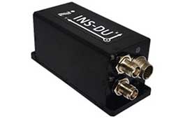
Photo: Inertial Labs
The INS-DU is a high-performance strapdown inertial navigation system (INS) that determines position, velocity and absolute orientation of a platform it is mounted to. Its dual-antenna u-blox receiver provides 1-cm real-time kinematic (RTK) position from RTCM 3 RTK corrections and supports multiple GNSS constellations. Designed for UAVs, land vehicles and marine vessels, the INS-DU uses a range of aiding data to deliver a highly accurate solution for GNSS-denied environments. It uses a miniAHRS with 3-axes each of precision magnetometers, accelerometers and gyroscopes to provide orientation. It contains algorithms for the motion of robots, autonomous vehicles and antennas.
The high-accuracy tactical-grade STIM277H gyro module and STIM377H inertial measurement unit (IMU) were designed to meet space segment needs. Both have hermetic aluminum enclosures, and all parts are tested for fine and gross leak to conform to MIL-STD-883J, Class H. While a commercial off-the-shelf (COTS) product, Sensonor has carried out extensive radiation characterizations. The design is tested for a 20+ years operating life through high-temperature operating life (HTOL) testing. Backwardly compatible with Sensonor’s other IMU and gyro modules, STIM277H and STIM377H are designed for satellite attitude and orbit control systems (AOCS), launchers, portable target acquisition systems, UAV payloads, land navigation systems, turret stabilization, missile stability and GNSS-supported navigation systems.
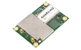
The AsteRx-m3 family features GPS/GNSS OEM boards optimized for power consumption and ease of integration. An easy-to-integrate design enables short set-up times and faster time-to-market. The AsteRx-m3 offers multi-frequency, multi-constellation positioning combined with Septentrio’s GNSS+ technology while optimizing power. The AsteRx-m3 Pro rover receiver tracks signals from all available GNSS constellations on three frequencies, and operates both in single- and dual-antenna modes. The AsteRx-m3 ProBase is designed to operate as a reference station for RTK and PPP-RTK networks. The AsteRx-m3 Pro+ is a full-feature OEM receiver board flexible enough to fit into any application and to be used either as a rover or a base station in a single- or dual-antenna mode.
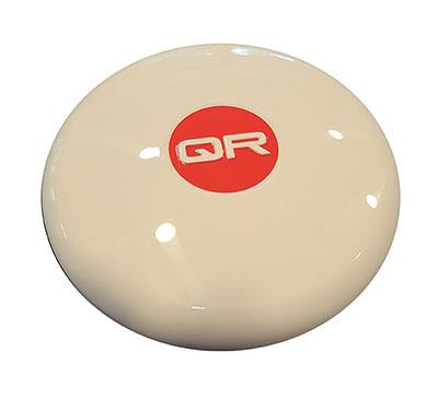
New anti-jamming antennas available are the QR200 GPS dual-frequency L1/L2 anti-jamming antenna, the QR201 GNSS multi-frequency band anti-jamming antenna, and the QR202 GNSS multi-frequency band anti-jamming antenna with additional L-band reception (1520–1560 MHz). All models provide robust GPS or GNSS navigation and block intentional jamming and unintentional RF interference timing or 3D positioning. All three are lightweight (230 grams for the QR1xx series and 500 grams for the QR2xx series) with low power consumption (1–1.5W typically, depending on configuration), and can be mounted on any platform (cars, poles, drones, etc.).
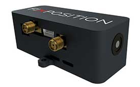
The Vision-RTK positioning sensor is a compact centimeter-accurate solution with high reliability and availability in challenging environments. The module integrates two real-time kinematic (RTK) GNSS receivers and visual inertial navigation. Its sensor-fusion algorithm is based on deep integration of GNSS, camera and inertial sensors. Real-time sensor fusion provides centimeter-accurate absolute positioning in any outdoor environment.
Deploying ground control targets on accurately surveyed ground control points (GCP) assures that a UAV lidar survey has been properly executed. UAV lidar surveys are typically undertaken in remote, rural and sometimes hazardous locations where no fixed points are available, such as solid surfaces or concrete features. Routescene’s GCPs are raised from the ground using a mini tripod. A built-in bubble level enables accurate leveling and removes the need for a tribrach. Robustly engineered, the targets stay in position during adverse and windy conditions, reducing the risk of repositioning during a survey. They are covered with highly retro-reflective material to provide high-intensity returns. As a result, the targets are easily identifiable and can be automatically extracted from the geo-referenced point cloud.
The Toughbook A3 Android tablet is aimed at the mobile workforce. It has an outdoor viewable screen and patented rain-touch functionality. With a 10.1-inch screen and 6-foot drop rating, the A3 enables users across industries to tackle tough jobs and critical applications. The Qualcomm SDM660 chipset, which supports BeiDou, Galileo, GLONASS, GPS, BeiDou QZSS and SBAS. 4G LTE Band 14 EM7511 multi carrier mobile broadband with GPS. The tablet has a powerful octa-core processor, an optional integrated barcode reader, an insertable smart card reader and an insertable stylus. The A3 has a 5-foot drop rating and IP65 certification for dust and water resistance.
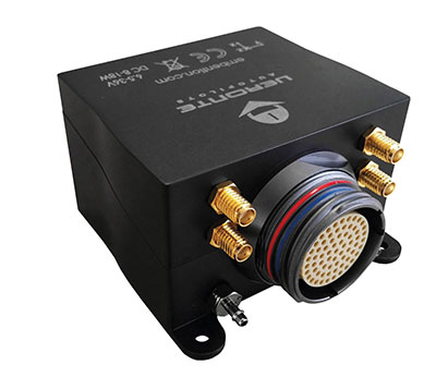
Veronte Autopilot 1X is a miniaturized avionics system for advanced control of unmanned systems. The control system embeds a suite of sensors and processors with datalink radio, with reduced size and weight. The control system Veronte Autopilot 1X adds fully autonomous control capabilities to any unmanned system for complete operation. The Veronte control system is fully configurable for payload, platform layout, control phases and control channels. It uses real-time kinematic (RTK) positioning and provides cloud connectivity, sense-and-avoid support, electromagnetic interference and vibration isolation.
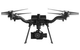
The Astro commercial drone platform is equipped with Freefly’s multi-band, real-time kinematic (RTK) system, which provides centimeter-level precision with a u-blox F9P GNSS module. The drone is equipped with a 60-megapixel Sony camera. A customized version of Skynode powers each Astro, providing LTE connectivity, an onboard Linux mission computer, and seamless connectivity to Auterion Mission Control and Cloud Suite. The Auterion ecosystem provides robust, secure and scalable drone planning, flight and compliance management solution.
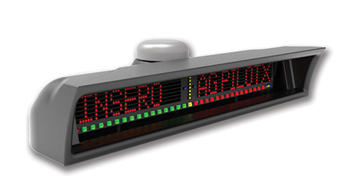
The guidance system AgPilotX for aerial applicators uses three wireless components: a GPS/GNSS lightbar, a hub and an Apple iPad. The smart components run off their own computer, communicating to each other wirelessly. The AgPilotX Smart Lightbar has onboard GPS+GLONASS as well as a GNSS antenna, so there is no need to run an antenna up to the aircraft canopy. The Lightbar logs the data, while a hub connects the switches (swath advance, swath decrement, spray on/off) and peripherals, and an iPad runs the interface software through an Apple App. All logs are saved as unique jobs and can be returned to at any time. The lightbar is not dependent upon the iPad to operate and will continue to work the active job even if you start using a different App or even shut the Apple device completely off.
Insero, inserosolutions.com
Antennas
High accuracy for autonomous vehicles, robotics
The Colosseum X XAHP.50 antenna. (Photo: Taoglas)
Two new active, multiband GNSS antennas are engineered for applications that require critical high-accuracy positioning and timing, including autonomous driving and precision agriculture. The MagmaX2 AA.200 is designed for space- and weight-constrained applications, such as robotic lawnmowers. Embedded versions are also available. It is a low-profile active multiband GNSS magnetic mount antenna for use across most major constellations including GPS (L1/L2/L5), GLONASS (G1/G2/G5), Galileo (E1/E5a/E5b) and BeiDou(B1/B2). The Colosseum X XAHP.50 is a geodetic-quality small-dome antenna suitable for a vehicle roof mount or pole mount. It is engineered to operate with high-precision capabilities on the full GNSS spectrum. Sub meter positional accuracy better than 55 cm is achievable, even without the use of RTK correctional services.
Senate poised to join House this week and override Trump’s veto
The U. S. Congress, especially the Armed Services Committees, have long been concerned about GPS and positioning, navigation, and timing (PNT) issues. Over the last two decades Congressional hearings, demands for reports, and investigations have dealt with acquisition, contingency plans for when space is not available, deliberate interference, and a host of other issues.
While these all evidenced Congress’ interest and concern, they were relatively passive measures.
The NDAA for 2021 seems to finalize Congress’ transition from an interested observer, mostly on the sidelines, to an active player in national PNT issues and policy.
This began to change in 2018 with passage of the National Timing Resilience and Security Act. It requires the Department of Transportation to establish a terrestrial timing system to backup GPS signals.
Then in 2019, Congress appropriated money for a GPS Backup Technology Demonstration. And the National Defense Authorization Act (NDAA) for 2020 required the Air Force to develop a prototype multi-GNSS receiver as part of its resiliency efforts.
The NDAA for 2021 seems to finalize Congress’ transition from an interested observer, mostly on the sidelines, to an active player in national PNT issues and policy.
Capitol Hill observers say this is the result of several things that have come to a head over the last year. Taken together, they have convinced many legislators that GPS is under threat and PNT issues are not being taken seriously enough by the executive branch. These include increased jamming and spoofing (especially by China and Russia), full implementation of China’s BeiDou system and its marketing to other nations as a superior alternative to GPS, the Federal Communications Commission’s (FCC) decision on Ligado Networks, and the Pentagon’s failure to respond to combatant commanders’ Joint Urgent Operational Needs Statements for non-GPS PNT.
Photo: Andrea Izzotti/Shutterstock.com
Here are some of the provisions of the 2021 NDAA of interest to the PNT community.
Military Multi-GNSS Receiver Prototype
The 2018 NDAA required the Defense Department to incorporate Europe’s Galileo and Japan’s QZSS satellite navigation signals into military user equipment. The idea was to make it more resilient to disruption. Also required was an investigation into using non-allied signals.
Apparently not satisfied with progress on this project, Congress mandated a project to develop a prototype multi-GNSS receiver as part of the 2020 NDAA.
The 2021 NDAA seems to indicate the Congress is still not happy. It withholds 20% of the funding for the Office of the Secretary of the Air Force until such time as the department certifies the prototype project is underway and provides briefings to the Senate and House Armed Services Committees.
Resilient Survivable PNT
Language in the 2021 NDAA also seems to show Congress is impatient with the Pentagon’s lack of responsiveness to combatant commanders’ requests for non-GPS PNT systems.
Section 1611 of the Act is entitled “Resilient and Survivable Positioning, Navigation, and Timing Capabilities.” It requires development, integration, and deployment of these capabilities for combatant commanders within two years. This, it says, is “… consistent with the timescale applicable to joint urgent operational needs statements…”
The act says the new PNT capabilities shall “generate resilient and survivable alternative positioning, navigation, and timing signals” and “process resilient survivable data provided by signals of opportunity and on-board sensor systems.”
The act also reverses the Defense Department’s 2018 PNT Strategy’s plan for future systems to be classified and for military use only. It directs the department to work with the National Security Council, Departments of Transportation, Homeland Security and others “to enable civilian and commercial adoption of technologies and capabilities for resilient and survivable alternative positioning, navigation, and timing capabilities to complement the global positioning system.”
To help ensure prompt action on this, the act requires a report to Congress within six months and authorizes the department to reprogram funds from other areas to finance the effort.
Responding to FCC’s Decision on Ligado Networks
By far the most PNT-related text in the 2021 NDAA includes a host of measures responding to FCC Order 20-48 approving an application by Ligado Networks. An order which the executive branch is on record as strongly opposing saying it will degrade GPS service for many.
Senator Jim Inhofe, chair of the Senate Armed Services Committee, has regularly expressed outrage at the FCC’s decision and has called for its reversal.
Among its provisions the act:
Requires the Department of Defense to estimate and report to Congress the cost of damage to department systems as a result of the FCC order.
Prohibits using department funds to upgrade or modify military equipment to make it resilient to interference caused by broadcasts in the spectrum allocated (the FCC order requires this to be funded by Ligado)
Prohibits contracting with any entity using the frequency bands allocated to Ligado unless the Secretary of Defense certifies the use will not interfere with GPS services
Requires the Secretary of Defense to contract with the National Academies of Sciences, Engineering, and Medicine for an independent technical review of the FCC order.
“Seen & Heard” is a monthly feature of GPS World magazine, traveling the world to capture interesting and unusual news stories involving the GNSS/PNT industry.
The 10-minute-long drone show included a flying dove with a wingspan of 600 meters, visible from three kilometers away. (Photo: u-blox)
A swarm of bird
A massive swarm of drones created a 10-minute show over Saint Petersburg, Russia, on Sept. 3. The 2,198 miniature UAVs danced for 10 minutes, forming images such as a dove with a wingspan of 600 meters, visible from three kilometers away. Geoscan built and programmed the drones, which use u-blox positioning modules.
Mobile GIS Services (MGISS) is helping the Yorkshire Wildlife Trust (YWT) deploy rugged handhelds to capture highly accurate survey measurements with cloud-based data storage and GIS software. Trust projects include restoring the largest, continuous blanket bog system in England. Blanket bog has been damaged by excessive burning, overgrazing, man-made drainage and extreme weather events. The YWT is using Spectra SP20 handheld GNSS receivers.
Photo: Genni Brookshire/Ceto Marine Research
Drones to the rescue
Seals and sea turtles face threats from humans, such as fishing nets. Marine biologist Genni Brookshire, Ceto Marine Research, and David Thirtyacre, Embry-Riddle Aeronautical University, are researching how drones can improve animal rescue, with help from Skyward, a Verizon Company. Her team is using drones to find and help distressed marine animals. “Using a drone before we respond to an animal to determine the animal’s condition — if it’s entangled, its body condition, if it’s sick — allows us to bring the proper equipment,” Brookshire said. “Using a drone allows us to reduce the stress on the animal, and increase our efficiency in responding to their unique situation.”
Photo: dzphotovideo/E+/Getty Images
Flight mysteries tracked
GNSS tech in a smart altimeter is guiding paragliders, skydivers, wingsuit pilots and other free-flying athletes. Dekunu Technologies’ One SmartAlti body-worn altimeter offers altitude and position information similar to what pilots obtain in their cockpits, increasing safety throughout freefall. Along with a multi-constellation u-blox chip, the device includes Bluetooth, Wi-Fi and USB. A cloud service incorporates 3D visualizations of the user’s jump data.
Swift Navigation‘s new Precision GNSS Module (PGM) is now available. The PGM module is designed to offer fast evaluation and a quick path to production for those requiring a precise positioning solution.
The PGM is available in a simple-to-use, industry-standard mPCIe (mini peripheral component interconnect express) format and is designed specifically for Swift’s Starling positioning engine running on a host application processor to deliver real-time precision navigation.
The PGM utilizes STMicroelectronics’ TeseoV chipset in Quectel’s multi-constellation, dual-band LG69T-AP receiver to create an affordable, easy-to-use solution for customers building industrial, last-mile and internet of things (IoT) platforms, Swift Navigation said.
The LG69T family of products, based on the ST TeseoV, is an designed for demanding precision applications that require centimeter accuracies. The LG69T-AP — supporting L1/L5 bands — has an integrated ST inertial measurement unit and processor to support dead reckoning for signal-compromised areas such as urban canyons, parking lots and underground structures.
According to Swift Navigation, this proven solution is ready for fast and easy integration and deployment — using industry-standard protocols — to reduce customer engineering investment and enable quick time to market.
This solution operates with the highest accuracy when used with Swift’s Skylark cloud-based, wide-area precise positioning service. Skylark delivers accuracy down to 10 cm. The solution supports standard RTCM OSR (Observation Space Representation) and SSR (State Space Representation) correction formats.
Skylark is available for integration into wide-area, high-precision positioning applications across the continental United States and Europe and is available in Japan, South Korea and Australia, with plans underway to expand globally. Skylark is an ever-expanding service and is scalable to service millions of users.
“We are excited to be offering the PGM utilizing the Quectel LG69T-AP receiver,” said Dave Huntingford, staff product manager at Swift Navigation. “The ability to provide a cost-effective, easily integrated solution, complete with corrections, opens up a host of opportunities for IoT, last-mile and industrial customers to benefit from precise positioning.”
“Quectel is delighted to be working with Swift Navigation to provide the market with an easy-to-use precision GNSS solution,” said Mark Murray, vice president of sales for GNSS and automotive at Quectel Wireless Solutions. “The LG69T-AP, together with Swift’s Starling positioning engine and Skylark corrections, is perfect for supporting applications and markets where <10-cm accuracy is required.”
This product is available today with full production by the first quarter of 2021; an evaluation kit is available. Contact Swift Navigation or Quectel.
UAVOS has debuted its Xservo-Series Hollow Shaft Servo Actuators, which feature embedded CANopen/EtherCAT servo drive.
The actuators include a built-in motion controller, which allows users to skip the complex stage of mechanical and electrical integration of a passive servo actuator with an external servo drive controller, the company said.
In addition, the actuators, which are encased with rugged, IP65-rated anodized aluminum alloy casing, boast a hollow shaft that makes it easy to pass power supply cables, shafts or laser beams directly through the servo actuator.
According to UAVOS, the actuators are capable of nx360 degree proportional rotation and are ideal for a wide range of rotary applications within UAVs and robotic platforms. New actuators are immune to shock and vibration and designed for use in harsh conditions, the company added.
“This is just the beginning of a series of product releases we are planning for this year, and our customers can be excited about what is about to come,” said Aliaksei Stratsilatau, CEO and lead developer at UAVOS. “Our incentive is to meet most of our customers’ requirements, and this is why we constantly invest in our R&D capacities and keep an ear close to the market.”
UAVOS Xservo-Series are designed to be used in industrial applications where high accuracy, high torque and low weight are essential.
A link to the live event will be sent to you two hours before the event. Your personalized event URL will be automatically generated by the ON24 system. To ensure receipt of the email, please whitelist this email address by adding it to your contacts: [email protected].
This presentation will begin at 1 p.m. Eastern / 10 a.m. Pacific / 7 p.m. Central European Time on Thursday, January 21st. A recording will also be sent to you the following day so you can watch it on-demand.
Audience members may arrive 15 minutes prior to live time. If you have any questions, please contact event producer Mackenzie Schoenherr at [email protected].