Aerial shot of Espoo, Finland, from a drone. (Photo: izhairguns/iStock/Getty Images Plus/Getty Images)
Expansion enables company to further accelerate cutting-edge GNSS/INS solutions for professional and industrial applications
Septentrio has opened a new Research & Development center in Espoo, Finland, to support the strong growth and ambitious expansion plans for its GNSS/INS solutions for professional and industrial applications.
The new office is strategically located in Espoo, well known as a high-tech hub with a long history of state-of-the-art GNSS and INS development, housing many leading technology companies as well as Aalto University.
“This new R&D center will support our strong growth and further accelerate our strategic agenda of becoming the leading independent GNSS/INS supplier for demanding applications in industrial, scientific and infrastructural domains,” said Antoon De Proft, CEO at Septentrio. “We also welcome Stefan Söderholm, who brings a wealth of experience to our team and will lead the new R&D center in Finland.”
“I am really excited to join Septentrio,” added Söderholm. “I have always been impressed by its technology and I look forward to be part of this great team that develops unique positioning solutions for the industry.”
Septentrio will be expanding its R&D team in the coming months with enthusiastic and highly qualified GNSS and INS engineers as well as software engineers. Stefan Söderholm will spearhead the establishment of the new R&D center and the recruitment efforts.
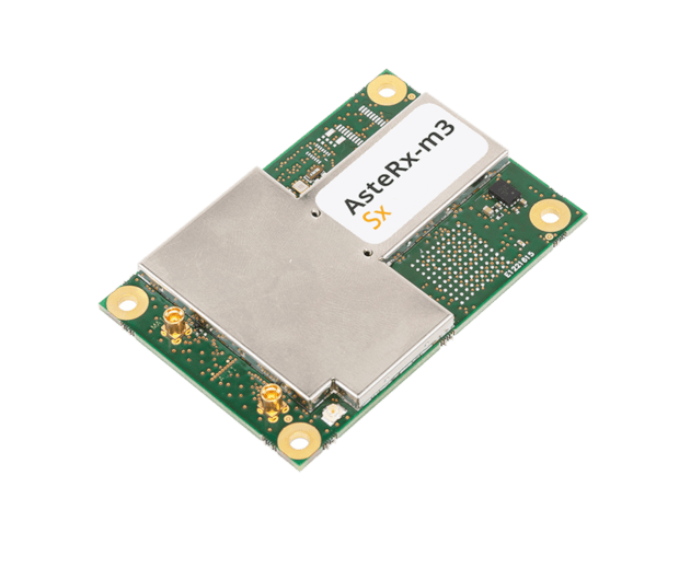
OEM receiver board includes Septentrio’s innovative SECORX-S service, bringing always-on sub-decimeter accuracy, without the need for additional correction subscriptions
Photo: Septentrio
Septentrio has launched the AsteRx-m3 Sx OEM board, a new dual-antenna receiver that combines Septentrio’s latest core GNSS technology with the SECORX-S sub-decimeter correction service to enable convenient plug-and-play positioning.
High-accuracy positioning is available directly out of the box as GNSS corrections are automatically streamed to the receiver. This significantly simplifies the user’s GNSS receiver set-up process and eliminates completely the hassle of corrections service subscription and maintenance.
Corrections are delivered via internet or via L-band satellites ensuring sub-decimeter service even in remote locations where there is no easy internet access.
“With the AsteRx-m3 Sx, we combine our latest GNSS innovations of the AsteRx-m3 family with the convenience of the SECORX-S always-on corrections, all in the same product,” said Danilo Sabbatini, product manager at Septentrio. “This offers higher reliability and operational efficiency to our customers, at an even lower cost.”
With its dual-antenna configuration, AsteRx-m3 Sx offers heading information immediately from power-up, allowing path optimization and fully informed navigation from mission start. Septentrio’s renowned GNSS+ algorithm suite ensures robust and reliable operation in challenging environments even in the presence of RF interference and under heavy vibrations, the company said.
AsteRx-m3 Sx offers PPP-RTK sub-decimeter accuracy with fast convergence time in the U.S. and Europe.
Movement, closeness, privacy — many things we took for granted a few months ago have become luxuries after the onset of COVID-19. To get an understanding of the scale and impact of the virus, we can look at global movement trends of people and merchandise using GNSS technology.
Marine
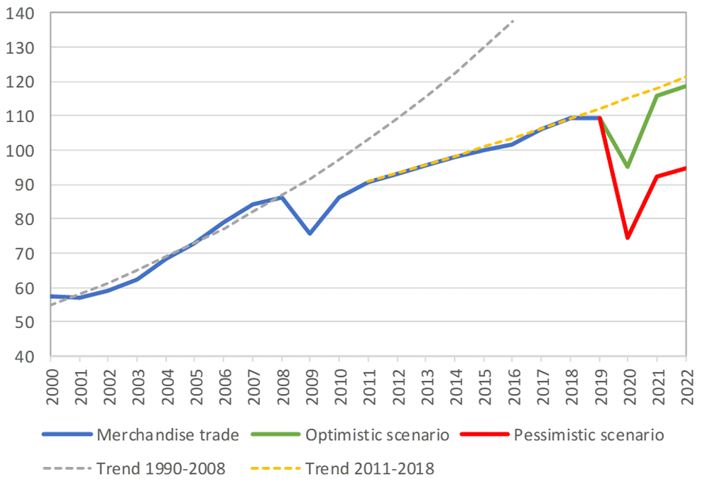
Before the coronavirus pandemic, globalization seemed to be increasing endlessly. Now, we face new trade restrictions, protectionist policies, and a global economic downturn that threatens to stunt growth for years to come.
In April, the World Trade Organization (WTO) forecast that global trade would fall by between 13% and 32% in 2020, surpassing the “great trade collapse” of 2009 spurred by the global financial crisis.
However, the situation isn’t completely bleak. According to a recent Tradeshift report, global trade decreased by 14.8% in the second quarter of 2020, putting us on the optimistic end of the WTO estimate. June saw a rise in trade activity, suggesting that we may be recovering from the initial effects of the pandemic.
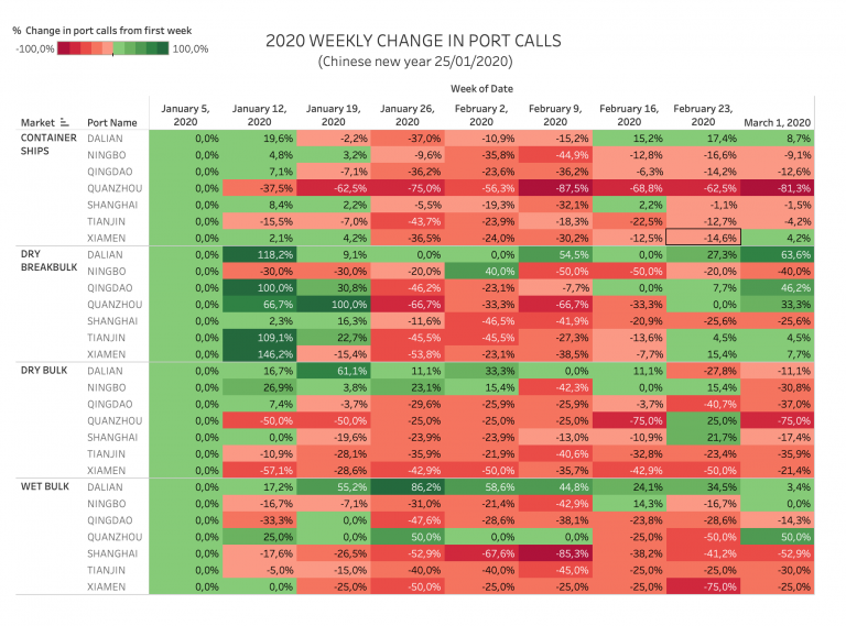
Cargo vessels, tankers, tugs, and other kinds of commercial ships are equipped with satellite navigation devices that can receive information from GNSS satellites to compute precise location and time. Maritime tracking insights obtained via GNSS/GPS signals are a great method for measuring the impact of the coronavirus on trade.
Photo: shaunl/E+/Getty Images
GPS data from MarineTraffic shows that ship arrivals decreased in nearly all of China’s ports from January to March.
Source: MarineTraffic
Just as trade shipping began to pick up in China, the United States and Europe were hit hard by the pandemic. However, shipments have now begun to climb worldwide to compensate for cancellations earlier this year.
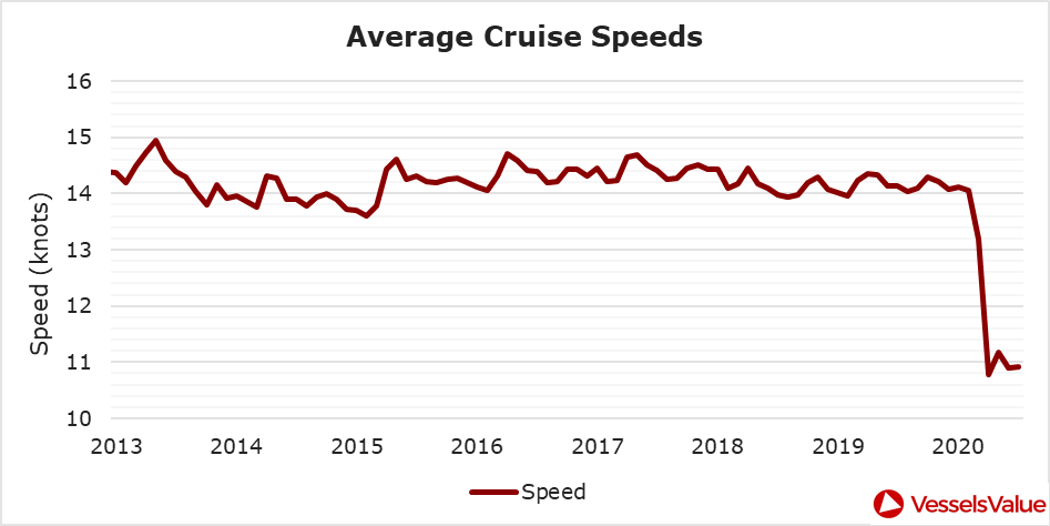
The cruise industry, on the other hand, shows little indication of recovery. Cruises were the fastest growing segment of the travel industry over the past five years — until the pandemic hit.
On June 19, the Cruise Line International Association (CLIA) and Centers for Disease Control and Prevention (CDC) announced a “no sail order” for cruise ships. The order has been extended through Sept. 30. Furthermore, the cruise industry’s reputation has been damaged by multiple outbreaks on ships, most recently the MS Roald Amundsen of Norway. At least 43 people were infected on the MS Roald Amundsen, and Norway has now banned cruise ships with more than 100 passengers from disembarking at Norwegian ports.
Maritime intelligence company VesselsValue is using AIS data to map cruise ship activity throughout the pandemic. They have noted that while cruise ships typically sail at 13.5 knots to 15 knots, average speed has dropped to 11 knots in 2020 as ships attempt to lower fuel costs. Port-to-port sailings have declined for the 10 most popular cruise routes.
Source: VesselsValueSource: VesselsValue
Most of the port-to-port sailings that constitute the 2020 columns in the above graph actually represent ships being repositioned for a break in service, also called a “layup.” Layups can cost cruise companies millions of dollars per month, but with no sail orders and port closures, they are a necessary expense.
According to the Oxford COVID-19 Government Response Tracker, a real-time monitoring system that evaluates government policies, April marked the strictest lockdown measures across all 133 available coastal countries. The tracker uses a stringency index between 0 and 100 based on national containment and closure policies.
Source: Oxford COVID-19 Government Response Tracker
Air
Commercial air traffic has decreased as well. According to GPS flight tracking service Flightradar24, the number of global daily flights was slashed by nearly two thirds between March and April. While there were 15,012 flights in the air at 15:00 UTC on March 7, there were only 5,275 at the same time on April 7.
Global air traffic March 7, 2020. (Source: Flightradar24)Global air traffic April 7, 2020. (Source: Flightradar24)
There were 55% fewer flights in the last week of March 2020 than in the last week of March 2019. While all types of air traffic have been reduced for fears of infection, the coronavirus has especially decimated demand for passenger flights. Passenger airlines across the world have canceled flights and cut capacity for the foreseeable future. Some passenger airlines have even switched to transporting cargo in a desperate attempt to avoid bankruptcy.
Looking at regional tracking data can further illuminate the impact of COVID-19 on air travel. Travel restrictions and border closures were enacted en masse in late March, though some nations adopted more stringent policies than others.
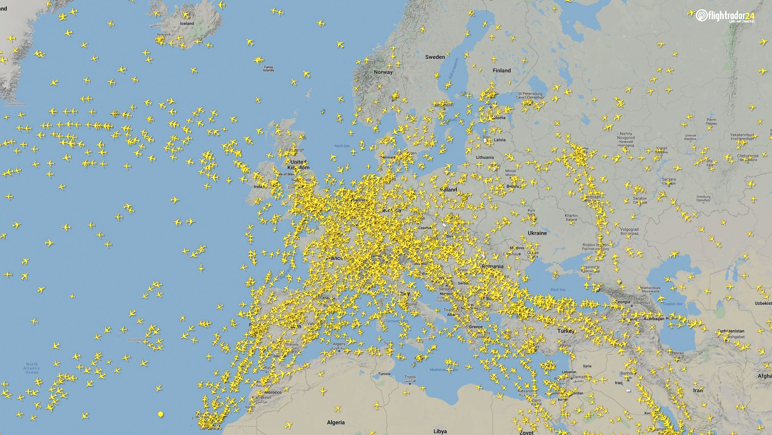
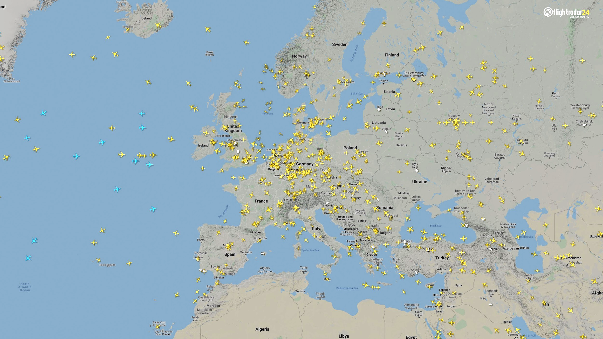
Europe
The number of flights in Europe has plummeted since the onset of the coronavirus pandemic. There were 2,400 fewer flights in Europe on April 7 than March 7.
Air traffic over Europe March 7, 2020. (Source: Flightradar24)Air traffic over Europe April 7, 2020. (Source: Flightradar24)
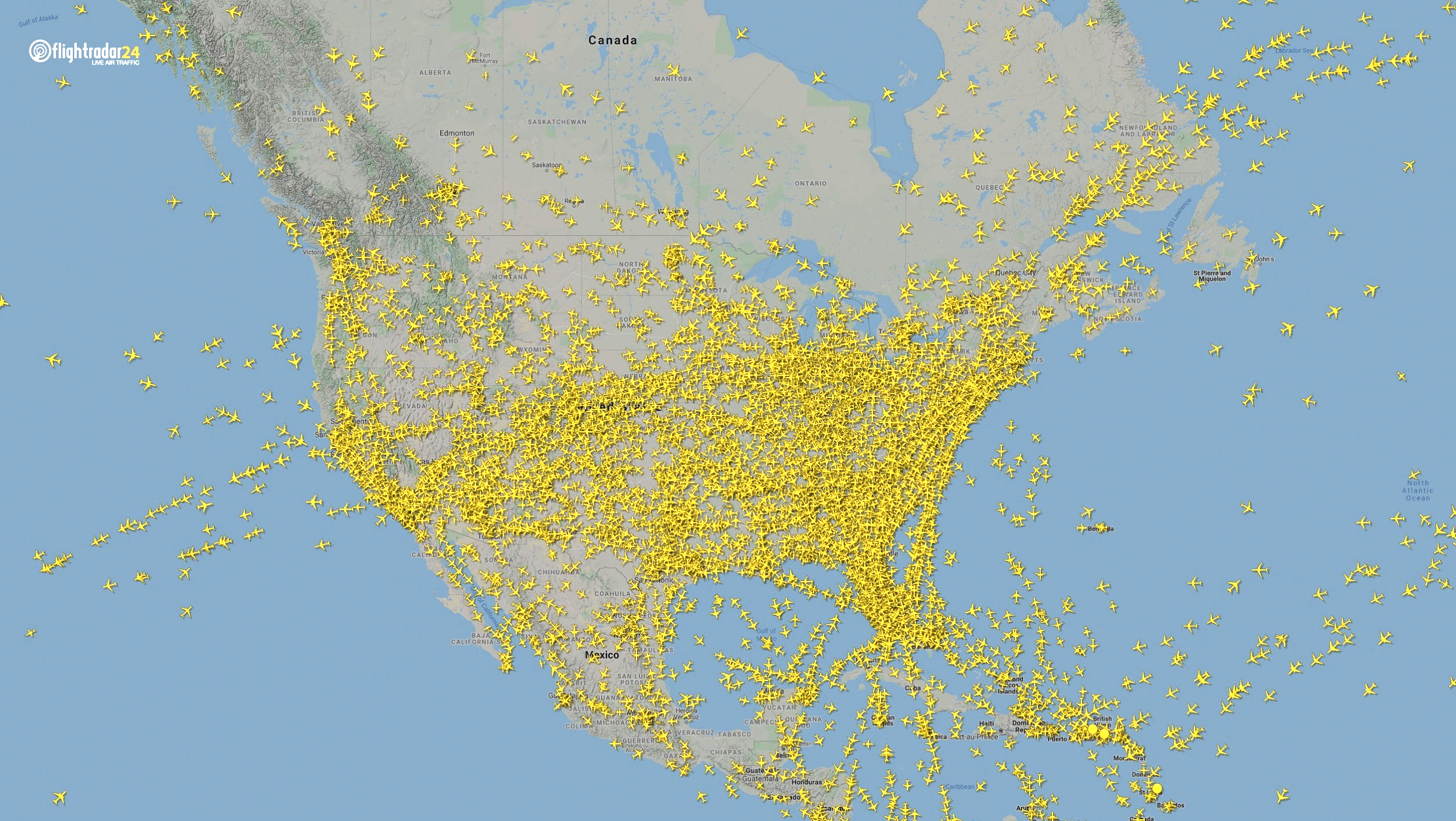
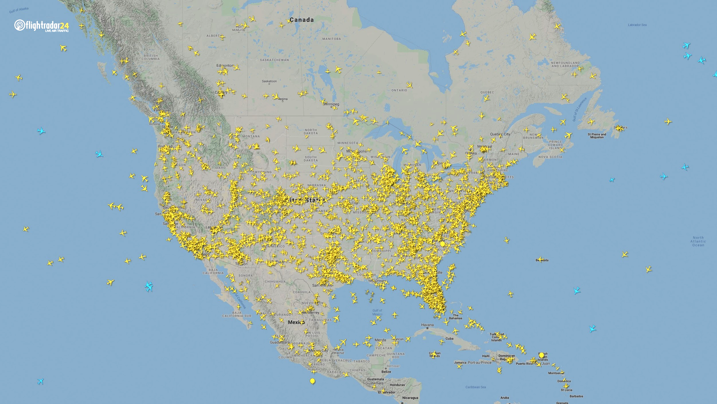
North America
Though air travel has been disrupted across North America, the United States remains significantly more busy than its neighbors. The March 7 image shows 8,400 flights while the April 7 image shows 2,950 flights, most of them concentrated over the United States.
Air traffic over North America March 7, 2020. (Source: Flightradar24)Air traffic over North America April 7, 2020. (Source: Flightradar24)
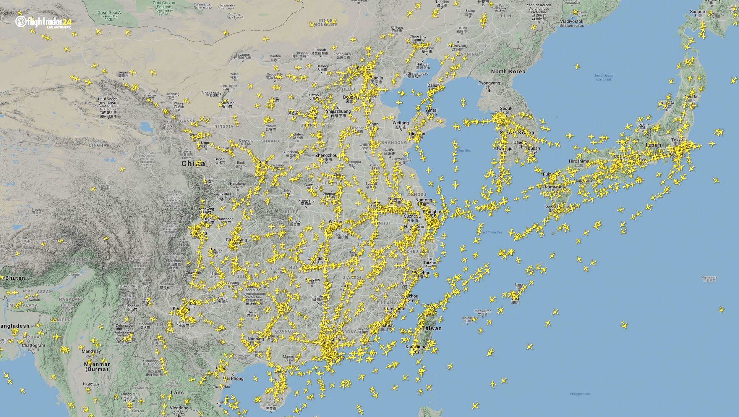
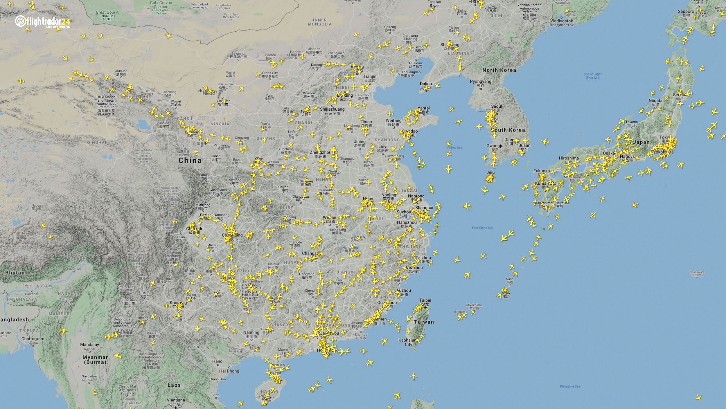
East Asia
The decrease in air traffic over East Asia has been severe and persistent. Since China and its neighbors began to experience a trade downturn as early as the third week of January, we can compare January 7 to April 7 to capture the effects of the coronavirus. As of late July, air traffic at China’s busiest airports was still down approximately 60% from normal levels.
Air traffic over East Asia January 7. (Source: Flightradar24)Air traffic over East Asia April 7. (Source: Flightradar24)
Ground
Google has released — and continues to update — a series of community mobility reports that chart movement trends in public spaces. The reports are a compilation of GPS data for Google users across the world.
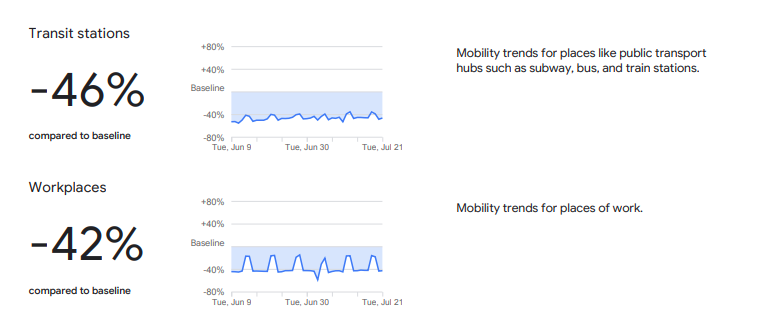
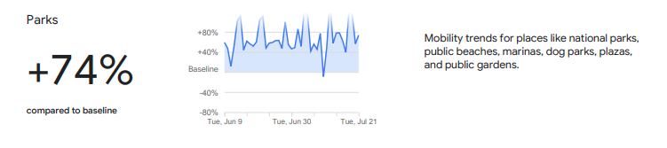
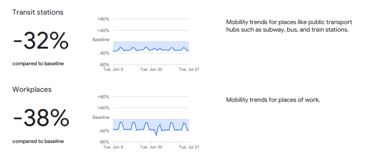
Mobility changes are particularly stark for regions hit hard by the coronavirus. New York state showed a 46% reduction in visits to transit stations and a 42% reduction in visits to workplaces in June and July compared to pre-pandemic baseline levels. New Yorkers are also visiting parks 74% more often.
Screenshot: GoogleScreenshot: Google
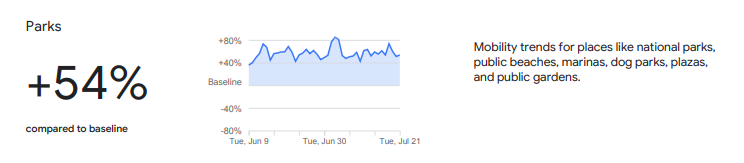
Trends in the United States as a whole are also dramatic.
Screenshot: GoogleScreenshot: Google
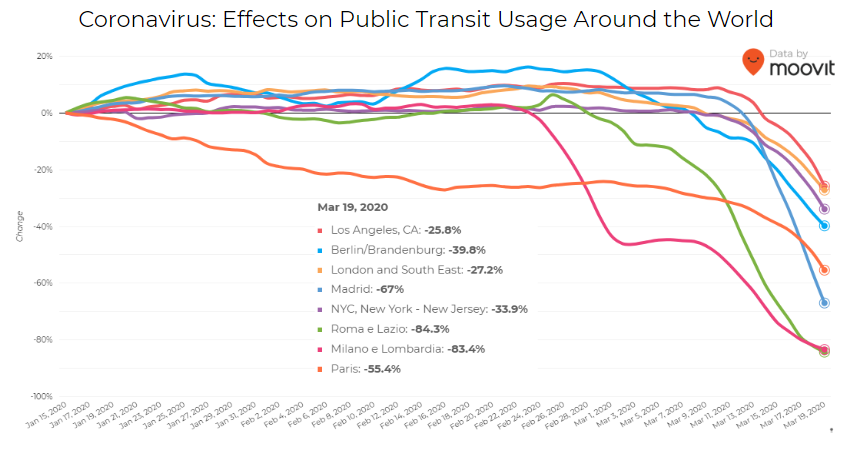
Israeli journey-planning app Moovit is using mobile phone data to document trends in public transit ridership. Many of the world’s largest metropolitan cities experienced a steep decline in ridership between mid-January and late March. Millions of people that rely on mass transit have had to cope with cumbersome rules and the danger of catching the virus itself. Efforts to reduce overcrowding on trains and buses have translated into reduced capacity requirements and therefore, lengthy wait times. The rise of remote work has also lowered public transit ridership.
Screenshot: Moovit
Italy was hit particularly hard – and early – by the pandemic. Two large outbreaks occurred in Northern Italy in late February, prompting widespread closures and government-mandated quarantines in Lombardy and 14 neighboring provinces. Public transit ridership plummeted when the quarantine took effect in early March.
Screenshot: Moovit
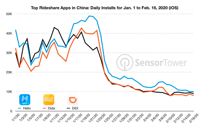
Usage of GPS-reliant ride-hailing apps has also dropped severely. Daily installs of China’s three biggest ride-hailing apps were down 75% the week of February 10 compared to the same week in 2019.
Source: Sensor Tower
American ride-hailing giants Uber and Lyft have seen similar losses. However, business for food delivery apps like Uber Eats and Grubhub are on the rise as more people stay home instead of grocery shopping.
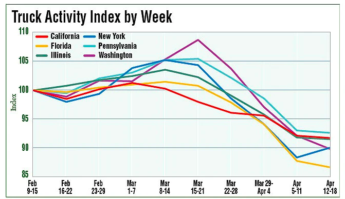
The impacts of COVID-19 have been less severe — but still significant — for the trucking industry. The U.S. trucking industry is an economic powerhouse, typically generating over 700 billion in annual revenue and transporting 72.5% of American freight. The American Transportation Research Institute generated a truck activity index based on GPS data across six states from the week of February 9 to the week of February 12. The data shows an initial spike in trucking operations due to increased demand for consumer goods and medical supplies. However, as stay-at-home orders and restrictions ceased business operations across the country, truck activity declined.
Source: American Transportation Research Institute
Coronavirus safety restrictions adopted by countries across the world have generally begun to loosen up, for better or for worse. It will be interesting to see how the coming months unfold through the lens of GNSS data.
Roi Mitt works for Regulus Cyber, a company researching GPS cybersecurity and offering various software products to protect the integrity, reliability and security of GNSS devices. The company’s products are designed for multiple industries using GPS-based time and location, in order to ensure a future in which GNSS technology is safe and reliable to use.
Emcore achieved success in an ultra-high-altitude flight simulation conducted by CAST Navigation, which tested Emcore’s SDN500 inertial navigation system (INS).
Emcore is a provider of advanced mixed-signal products that serve the aerospace & defense and broadband communications markets.CAST Navigation builds simulators for testing and validating GNSS/INS performance in high-end navigation systems.
CAST used Emcore’s SDN500 inertial navigation system (INS) for the test, which required simulating performance at an altitude more than 24,000 meters and velocities over 600 m/s. Only a few aircraft in the world have such capabilities, including the SR-71 Blackbird, but it is not practical to participate in a test flight on the SR-71. Simulating the SDN500 INS test flight to specific customer profiles on a CAST system is straightforward and cost-effective.
Testing began with a stationary period on the ground while the SDN500 initialized and transitioned into air-navigation mode. Then the flight trajectory entered a series of maneuvers, speed and altitude changes that provided observability for various parameters with corresponding changes in the calculated figures.
Emcore relies on GNSS/INS simulators for hardware-in-the-loop testing to verify the expected performance of algorithms. Emcore CORE sought to validate the velocity and altitude limits of a new GNSS receiver along with the algorithm performance in a tactical-grade SDN500 system. In the final analysis, the GNSS receiver and navigation algorithm was confirmed to operate as expected throughout the operation for all three of the customer’s dynamic constraint scenarios.
“We were extremely pleased to demonstrate how Emcore takes advantage of the functionality contained in the CAST simulator to prove-out our robust product performance in customer environments,” said David Hoyh, director of sales and marketing for navigation products, Emcore..
“During the times when there was no valid solution from the GNSS receiver, the algorithm maintained an accurate solution using only the data from the IMU,” explained Andy Williams, senior field application engineer at Emcore who spearheaded the effort. “In addition, there was no algorithm instability or discontinuity when the GNSS receiver resumed, providing a solution to the algorithm. Throughout this entire profile, even when GNSS signal is lost, the SDN500 maintains an accurate navigation solution. This test is not possible without the synchronized GNSS radio frequency and trajectory matching IMU data provided by the CAST system.”
Source: “A True Reference. Theory Meets Reality in Synchronized Simulation Environments,” Inside GNSS, Volume 15/Number 5, September/October 2020, Pages 28, 29, 30.
The UPP results will provide a proof of concept for UTM capabilities and serve as the basis for policy considerations, standards development and the implementation of a UTM system.
“The demonstrations will help move us closer to safe beyond-visual-line-of-sight drone operations,” said Pamela Whitley, the FAA’s acting assistant administrator for NextGen. “Flight testing UTM capabilities in high-density airspace will help us develop policy for safely and efficiently integrating drones into our national airspace while benefiting and serving communities.”
The demonstrations showcased emerging UTM capabilities that will support beyond-visual-line-of-sight (BVLOS) operations:
The FAA UTM Flight Information Management System prototype and infrastructure, which gives the FAA access to information from industry and other stakeholders.
New technologies and data to validate the latest international standards for remote identification and support authorized users with specific operator data.
In-flight separation from other drones or manned aircraft in high-density airspace to validate recently proposed international UTM standards to help drones avoid each other.
UAS volume reservations to notify drone operators of emergencies and make sure other UTM capabilities work properly in these scenarios.
Secure information exchanges between the FAA, industry and authorized users to ensure data integrity.
Each event attracted more than 100 participants and included local and state elected officials and representatives from international civil aviation authorities. Both test sites collaborated with drone operators and local public safety agencies to demonstrate scenarios that featured various complex UTM capabilities working together to support BVLOS operations with increasing volumes and densities.
MAAP hosted an event on Oct. 28 in partnership with UAS Service Suppliers (USS) AirMap, AiRXOS, ANRA Technologies, and Wing. On Nov. 9, NYUASTS hosted its showcase in coordination with the Griffiss International Airport, Northeast UAS Airspace Integration Research Alliance (NUAIR), and USS partners AiRXOS, ANRA Technologies, AX Enterprize, and OneSky.
The FAA has worked closely with NASA, industry and other stakeholders since 2017 to identify the initial set of capabilities needed to support small drone operations and advance UTM. The FAA Reauthorization Act of 2018 extended the objectives of the program to further enable safe BVLOS drone operations, paving the way for the program.
Stay tuned for more updates on how emerging technologies are being field tested to support the growing UAS industry.
“Seen & Heard” is a monthly feature of GPS World magazine, traveling the world to capture interesting and unusual news stories involving the GNSS/PNT industry.
Photo: welcomia/ iStock / Getty Images Plus / Getty Images
COVID brings better measurements
A new study shows that the quality of GNSS reflectometry measurements may have improved significantly during the pandemic because of the lack of cars parked near the ground station. The study, carried out by geodesists from the University of Bonn, investigated the location of a precise GNSS antenna in Boston, Massachusetts, where parked cars near the ground station decreased accuracy from 2 to 4 centimeters. GNSS reflectometry is used for earthquake early warning systems, determining flood risks, and many other geodesy applications. Read more about the study.
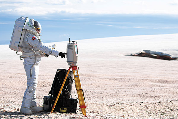
Photo: Daniel Leeb/Iceland Space Agency
But can you press the right button?
A Riegl long-range terrestrial laser scanner helped field test the newly designed MS1 Mars Analog Spacesuit. The test simulated how the new spacesuit design would perform in a polar, Mars-like environment ‚ in this case atop the Grimsvötn Volcano on the Vatnajokull Glacier in Iceland. The field test was part of a research expedition conducted by the Iceland Space Agency. The team included NASA Coordinator and Rhode Island School of Design (RISD) Professor Michael Lye, who led the team that designed the MS1, and doctoral students from the University of Iceland.
In June, a fleet of 300 Chinese fishing vessels entered the waters of the Galápagos Islands, reports environmental news website Mongabay. The ships had ostensibly turned off their GNSS-based automatic identification system (AIS) transponders to engage in illegal activities. Their presence was detected by their overhead lights and industrial jigging machines to attract and catch squid. An analysis of radio-signal data also detected unidentified ships within Ecuador’s Galápagos exclusive economic zone (EEZ).vThe new data provide additional, but still inconclusive, evidence that the Chinese fleet may have entered Ecuador’s EEZ.
A pilot program in Shenzhen will use China’s BeiDou to regulate bike-sharing and address the problem of bikes parked chaotically or in unpermitted areas, according to Chinese news service Caixin. The program is part of Beijing’s push for wider adoption and commercialization of BeiDou. With guidance from the city’s transportation bureau, BeiDou modules on shared bikes will display parking spots. Users will have to park them within geofenced parking spots.
The U.S. Space-Based Positioning, Navigation and Timing (PNT) Policy tasked the NASA Administrator to develop and provide requirements for the use of GPS and its augmentations to support civil space systems. NASA is exploring the viability and enhancement of GPS and GNSS signals in the Space Service Volume and beyond to support operational U.S. missions and civil space systems. Spirent GNSS solutions and expertise will support testing of the GNSS receivers intended to be deployed in the upcoming lunar exploration, the company said.
“For over two decades, NASA and other space users have selected us to provide leading-edge test and development solutions for missions ranging from short suborbital flights to weeks-long orbits beyond geosynchronous altitudes,” said Ellen Hall, president at Spirent Federal Systems. “Working collaboratively with our customers enables us to meet their demanding test and development needs with the trusted solutions for which Spirent is known.”
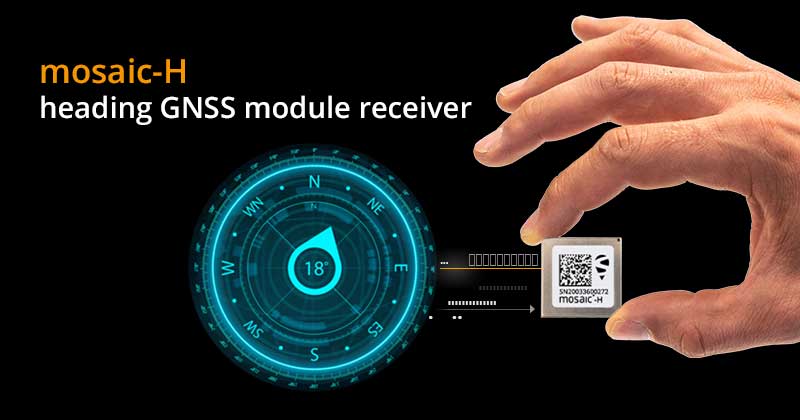
Septentrio has expanded its GNSS module portfolio with the launch of its mosaic-H heading receiver. According to the company, with dual-antenna capabilities, this surface mount module delivers reliable heading and pitch or heading and roll information on top of centimeter-level positioning.
mosaic-H is the new addition to Septentrio’s existing mosaic module family, which already includes RTK and timing modules, as well as modules with integrated GNSS corrections. According to Septentrio, having a single standard footprint across multiple specialized receiver modules enables integrators to create multiple application-specific products based on a single design.
“The mosaic GNSS receivers have set a new performance standard among high-precision GNSS modules,” said Francois Freulon, head of product management at Septentrio. “Adding a second antenna input into the single form factor of mosaic demonstrates Septentrio’s leading position in the high-precision module market. Thanks to its ultra-small dimensions and low power consumption, mosaic-H is the ideal navigation and control solution for robotics, UAVs and autonomous applications which require ultra-robust and secure positioning and heading.”
mosaic-H delivers orientation angles immediately from the start, helping initialize inertial systems which otherwise would require movement before they can measure 3D orientation. INS initialization with GNSS attitude from power-up allows machine trajectory path optimization and fully informed navigation of robotic systems immediately from mission start, Septentrio added.
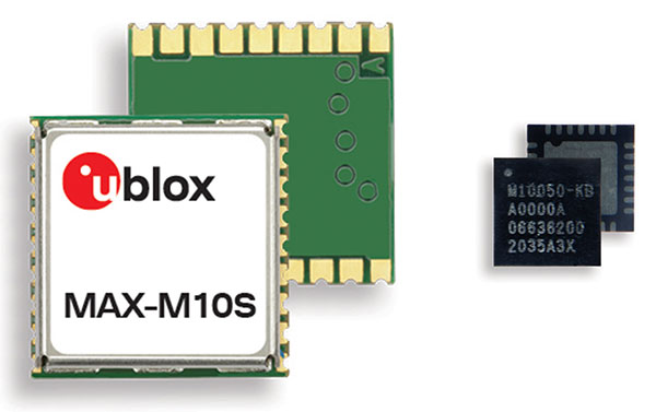
M10 receiver platform can track four GNSS constellations, even in challenging environments
Photo: u-blox
U-blox’s new M10 GNSS platform is designed for ultra-low-power high-performance positioning applications such as sport watches and asset trackers.
The M10 positioning platform can track up to four GNSS constellations at once to deliver positioning data even in challenging environments such as deep urban canyons. The receiver’s Super-S technology helps distinguish positioning signals from background noise to capture positioning data even when satellite signals are weak.
Its high RF sensitivity also enables it to work well with small antennas, making it suitable for compact product designs. In sport watches, for instance, u-blox M10 guarantees highly dynamic positioning accuracy during a run in cities, woods or under an open sky, while preserving battery life.
Low power consumption. The u-blox M10 is designed to consume 12mW in continuous tracking mode, five times less than the power consumed by previous u-blox meter-level GNSS technology, making it beneficial for battery-powered applications.
U-blox M10’s enhanced RF sensitivity also cuts the time it takes for the platform to achieve a first position fix when initialized, further reducing systemic power consumption. And switching to the improved Super-E mode can extend battery life even more.
This new GNSS platform will be supported by AssistNow, u-blox’s assisted GNSS service, to accelerate positioning and improve accuracy. Depending on the required level of assistance, the service is available free of charge or for a recurring fee.
Jamming detection. The u-blox M10 platform benefits from u-blox’s experience in building robust GNSS receivers, incorporating proven techniques for detecting spoofed signals through the analysis of raw GNSS data, jamming-detection strategies, and embedded filters to mitigate the effects of in-band RF interference.
“U-blox can be proud of over 20 years of experience with GNSS technology, and with u-blox M10 we are setting a new benchmark in ultra-low power high performance positioning applications,” said Bernd Heidtmann, product manager, Product Center Positioning, u-blox. “We have increased concurrent reception of satellite signals by a GNSS platform from three to four constellations and improved the power consumption level five-fold compared to previous generations while shrinking the chip size by 35 percent.”
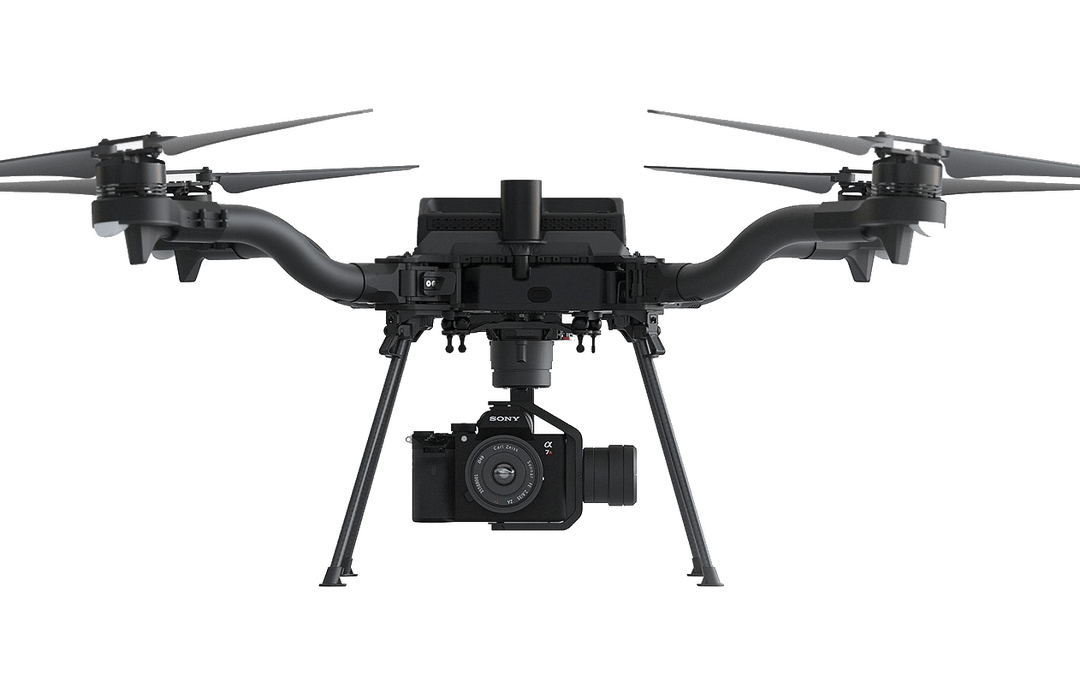
Esri is offering two major capabilities in Site Scan for ArcGIS that will enable governments and critical infrastructure organizations to meet hardware and software regulations in the United States and Europe. Site Scan is Esri’s unmanned aerial systems flight planning and processing solution.
Through an established partnership with Auterion, creator of an open-source drone autopilot operating system, security-conscious U.S. organizations will be able to use Site Scan to plan and execute missions with Auterion’s Freefly Astro drone.
In Europe, data from publicly funded or critical infrastructure projects cannot leave the European Union (EU). For these organizations, a new and fully independent instance of Site Scan for ArcGIS has been deployed to a server cluster in Ireland, ensuring that organizational data resides within the region.
Site Scan for ArcGIS is used by organizations that require drone imagery for visual inspections, site monitoring, asset management and situational awareness. It’s an all-in-one, cloud-based drone mapping solution for managing fleets and collecting, processing, analyzing, and sharing data products. Industries using this solution include architecture, engineering, construction, natural resources, infrastructure and government.
Freefly Astro uses U.S. Department of Defense-approved Blue sUAS software architecture from Auterion, and is fully supported by Site Scan. The first vehicle integrates the software with the Freefly Astro, with more vehicles becoming available.
Auterion’s secure, integrated workflow for mapping uses the Freefly Astro drone, Sony A7R4 camera and Esri Site Scan within a single platform.
The Freefly Astro and Site Scan integration will be available by December. The European deployment of Site Scan is available now.
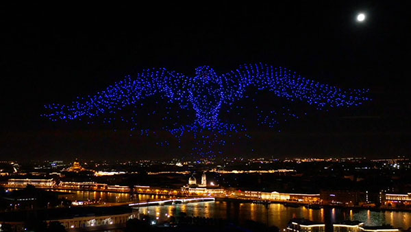
The 10-minute-long drone show included a flying dove with a wingspan of 600 meters, visible from three kilometers away. (Photo: u-blox)
U-blox supplied the high-accuracy technology that made it possible to fly a massive swarm of drones. The simultaneous flight of 2,198 miniature unmanned aerial vehicles (UAVs) was launched into the night sky over Saint Petersburg, Russia, on Sept. 3.
The 10-minute-long drone show included a flying dove with a wingspan of 600 meters, visible from three kilometers away.
Geoscan, which built and programmed the drones and ran the display, chose u-blox positioning technology for its combination of accuracy, reliability, performance and ability to access positional data from both the GLONASS and GPS satellite navigation constellations.
The 10-centimeter-wide Geoscan Salute drones were designed for use in group flights and drone shows. The drones use u-blox NEO-M8P high-precision GNSS modules to provide the positioning data to create a fluid drone show. Salute drones return to their base stations automatically at the end of a show.
The NEO-M8P module implements a real-time kinematic (RTK) approach that improves positional accuracy by comparing the phase of a signal being broadcast from a positioning satellite with that of the same signal that has been received and rebroadcast from a fixed base station. The accuracy gained in this way enables drones to calculate their relative positions to within millimeters, and their absolute positions to within 1 centimeter of the intended position.
Geoscan has been producing drone displays for the past two years, starting with 40 drones flying at once. “The u-blox modules in our Geoscan Salute drones have improved our drones’ positioning accuracies to about one centimeter, and have helped reduce pre-launch preparation time,” said Semen Lapko, head of Drone Show Project, Geoscan. “Drones now move more quickly and accurately, while also operating more efficiently.”
The first drone of Europe’s U-space TRACE project took its maiden flight Sept. 23. It carried an EGNOS-enabled beacon that allows the identification of the aircraft while guaranteeing accurate, robust positioning.
The drone lifted off at the ATLAS experimental flight center in Jaén, Spain, an aerodrome equipped for flight tests with unmanned aircraft systems.
The Regional Minister for Economic Transformation, Industry, Knowledge and Universities, Rogelio Velasco said, “This event shows Andalusia’s commitment to hosting initiatives that promote innovation in the region.”
Using enhanced EGNOS signals, the EU’s regional satellite-based augmentation system, TRACE supports the safe and effective integration of drones into U-space by providing essential services such as e-registration, e-identification and pre-tactical geofencing.
The smart beacon allows for remote identification of drones flying at a very low altitude, enabling safer integration of drones into airspace through the use of U-Space. This makes it easier for traditional aviation pilots to know the position of drones. The smart beacon also enables better traffic separation when integrated with U-space services, thanks to EGNOS.
“TRACE is a pioneering project in Europe that will allow us to demonstrate the advantages of EGNOS, particularly in terms of greater precision in locating drones,” said Luis Gómez, CEO of Alter Technology.
The TRACE project is funded by a GSA EGNOS Adoption in Aviation grant. It designed and developed a smart beacon that leverages the robust signal corrections of EGNOS to improve positioning accuracy, and thus the safety of drone operations at very low altitudes.
Carolina Jiménez, TRACE project manager at Alter Technology added, “TRACE will demonstrate compliance with the European Drone Regulation, an important aspect within the Alter business line, since one of the fundamental requirements in this new regulatory framework is that each system has the capacity for remote identification for future secure integration within the air space for these systems (U-Space).
The TRACE project is led by Alter Technology, and is a result of collaboration among European companies such as Unifly (Belgium), Pildo Labs and FADA-CATEC (Spain).
Vodafone, together with CATEC, presented the 5G Lab of ATLAS within the 5G initiative of RED.ES. A use case of 5G with drones for urgent defibrillator delivery was demonstrated with the participation of Fundación SSG, Vodafone and the technological support of CATEC.
TRACE project partners include:
Alter Technology provides engineering and test services for electronic systems and E.E.E. components within the space and harsh environment markets.
FADA-CATEC, the Advanced Aerospace Technologies Center, promotes and develops creation of technological knowledge and its transfer to the productive aerospace industry.
Pildo Labs is an engineering company that specializes in aeronautics and aerospace technology and services.
Unifly is a software company with a platform for the safe integration of drones into the airspace.
The European GNSS Agency (GSA) manages operations, security and service provisions for Europe’s Galileo and EGNOS.
The drone market is expected to outstrip any other user base in the aviation market. According to estimations, revenues from drone-based services are expected to exceed 150 million euros by 2023. GNSS is a key enabling technology for drones and it is expected that its role will continue to grow. Solutions like TRACE that use European GNSS (EGNOS and Galileo) are differentiators that can be leveraged to safely integrate drones into non-segregated airspace and into the U-Space.
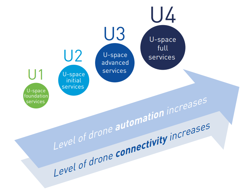
U-space
The progressive deployment of U-space is linked to the increasing availability of services and enabling technologies. Over time, U-space services will evolve as the level of automation of the drone increases, and advanced forms of interaction with the environment are enabled (including manned and unmanned aircraft).
These U-space services have been identified and gathered in four different phases, increasing the drone level of integration. Learn more in the U-space Blueprint.