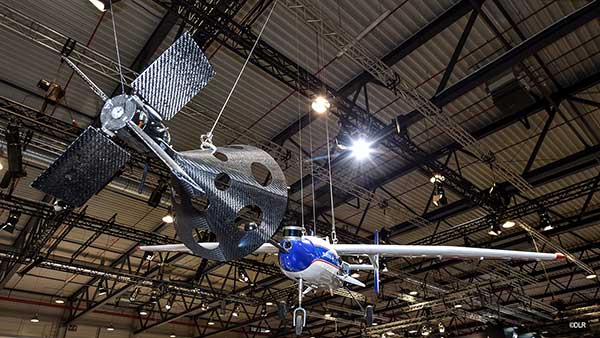
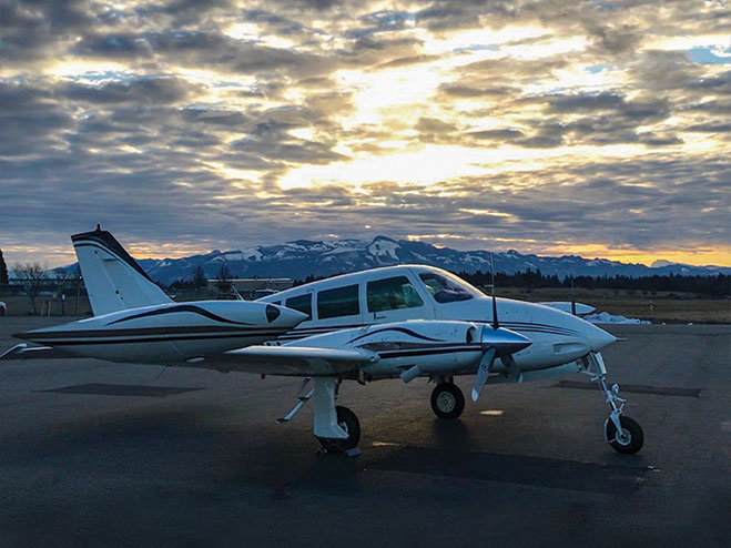
The FALCon research project has already carried out initial flight experiments with unmanned small aircraft. (Photo: German Aerospace Center)
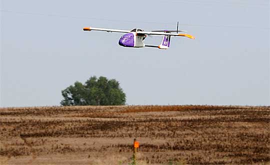
The parachute safety solution manufacturer Drone Rescue Systems GmbH is supporting the European research project FALCon, the “Formation flight for in-Air Launcher 1st stage Capturing demonstration.”
Under the leadership of the German Aerospace Center (Deutsches Zentrum für Luft- und Raumfahrt; DLR), research is being conducted on how launch vehicles can be returned to the launch site as efficiently as possible for re-use.
The aim of FALCon is to achieve cost-efficient and environmentally friendly satellite transport. The focus of the project lies on the return of rocket stages after launch. To be able to reuse these stages, efforts are being made to recapture them in the air using a “rocket catcher.”
For the next three years (March 2019 to February 2022) the focus will be on the development and flight demonstration of a technical solution for this idea. While still in the air, rocket stages are to be captured by a transport aircraft over the sea and pulled into the vicinity of the landing site. There, the stages are to land independently.
“We are proud to be part of the FALCon research project together with five international partners and DLR as part of HORIZON2020 (EC grant 821953), the EU’s largest research and innovation program to date. The capture and towing of rocket stages in flight, that is, an autonomous and safe landing, is a particularly interesting topic for us as a manufacturer of parachute safety solutions,” said Andreas Ploier, CEO of Drone Rescue Systems GmbH.
The research project has already carried out initial flight experiments with unmanned small aircraft.
Lynx–Lawrence & Mayo, an Indian engineering equipment providers, has expanded its portfolio to include specialized drones, through its partnership with ideaForge, India’s largest UAV manufacturer.
As part of the agreement, ideaForge’s drones equipped with more than a decade of UAV design expertise, will be accessible to Lynx – Lawrence and Mayo for applications across urban development, weather monitoring and testing, agro-technology and other sectors.
Developed by a team of Indian Institute of Technology Bombay graduates, ideaForge has been celebrated for its innovations in the unmanned aerial vehicle (UAV) domain. It built a small, light autopilot in 2009 and India’s first autonomous quadcopter UAV. Their designs have led the development of world class, indigenous UAVs for security and surveillance, reconnaissance, mapping, photogrammetry and other industrial applications. Now, their UAVs even come with the capability to meet the DGCA regulations, to ensure NPNT compliance.
Through this partnership, Lynx–Lawrence & Mayo will have access to ideaForge’s fleet of UAVs for inspection, surveillance, traffic and crowd management, and disaster management. The fleet includes:
Switch UAV – A fixed-wing vertical take-off and landing (VTOL) hybrid for terrain-independent deployment with long range, high endurance and high altitude capabilities.
Q-Series UAV – Enterprise specialist VTOL quadcopter built with military design philosophies.
Ninja UAV – Lightweight and economical micro UAV built specifically for mapping and advanced surveillance.
Netra Pro – Rugged quadcopter for maximum redundancy in extreme conditions.
Netra V-Series – Field-proven UAVs for mission-critical applications, integrated with high zoom HD real-time video transmission.
“We at Lynx have been driving innovation and excellence in advanced precision equipment for engineering and industry. With the addition of innovative UAVs from ideaForge, we are delighted to add a range of advanced and futuristic drones to our portfolio,” said Glenford D’souza , Lynx senior general manager. “We will be strategically deploying these products to create an integrated and specialised service/solution offering to our existing and potential clients. We look forward to a long term and fruitful partnership.”
IdeaForge has deployed more than 700 systems and has trained more than 1,200 pilots in services including the Indian Army, Navy and Air Force; state police forces; Indian railways; and many more agencies.
IdeaForge drones have been used in defense and homeland security for border monitoring, anti-terror operations, counter insurgency operations, disaster management, traffic monitoring, campus surveillance, crowd management and more.
With the flexibility to customize their drones for an array of requirements, ideaForge also provides end-to-end UAV solutions and services to the industrial and commercial sectors.
Kansas receives approval for first beyond-visual-line-of-sight drone flight in the nation using only onboard detect and avoid.
The Kansas Department of Transportation (KDOT) has received permission to conduct the first beyond-visual-line-of-sight (BVLOS) drone operation in the nation leveraging only onboard detect-and-avoid systems.
This is the first U.S. Federal Aviation Administration (FAA) authorized operation to fly without a requirement for visual observers or ground-based radar. It is the result of the 31-member Kansas UAS Integration Pilot Program (IPP) team efforts to advance drone technologies.
In a collaborative effort among Kansas State University Polytechnic Campus (K-State Polytechnic), Westar Energy, Iris Automation and KDOT, the Kansas IPP team will fly a nine-mile track to evaluate technologies to inspect power lines in rural Kansas. This approval is the first of its kind for long line linear infrastructure and is the first step to enable routine commercial infrastructure inspection across the state.
This is the first unmanned aerial vehicle (UAV) flight to leverage onboard sense and avoid systems alone for collision avoidance. It also marks the first required automated avoidance action.
Historically, all FAA-issued Part 107 BVLOS waivers have required visual observers or ground-based radar. These mitigations limit the possibility of true BVLOS flights, as they are typically prohibitively expensive and limit operations to pre-defined corridor areas with radar coverage.
This important milestone is facilitated by Kansas UAS IPP partner Iris Automation’s Casia onboard collision-avoidance system.
“The UAS industry has worked over 10 years to demonstrate the most significant commercial benefit of drone operations within the United States,” said Bob Brock, KDOT director of aviation. “We are proThe Applied Aviation Research Center on the K-State Polytechnic Campus, which assisted in development of the safety case that ultimately led to FAA approval, will be responsible for the training and flight operations with a cross-functional team from the KDOT IPP. Flights will take place over the next few months, providing the FAA with much-needed data on true BVLOS activity.d of the joint state, university and industry team that made this landmark decision possible.”
“The ability to fly BVLOS missions without ground-based radar or visual observers is a significant advancement, and Westar Energy views this as an opportunity to play a key role in shaping the future of UAS operations within the utility industry,” said Mike Kelly, Westar Energy Senior UAS coordinator. “Being able to operate under this waiver allows the Kansas IPP team the ability to research and develop truly scalable BVLOS UAS operations for the automated inspection of linear infrastructure.”
“We look forward to leveraging this waiver to integrate UAS technology into the transmission line inspection process,” said Kurt Carraway, UAS Executive Director of the K-State Polytechnic Applied Aviation Research Center. “We are certain that utilities will be able to quickly realize a return on investment while mitigating safety to their maintenance personnel and increasing the reliability of their infrastructure to the general public.”
“Flying rural missions like these without a human pilot onboard or costly radar on the ground is exponentially safer and more cost effective,” said Iris Automation CEO and Co-Founder Alexander Harmsen. “The FAA is trusting us to pave the way for a safer, scalable future together with this precedent-setting second approval of our system.”
The U.S. Department of Transportation selected Kansas Department of Transportation as one of nine participants in the FAA UAS IPP. This program allows state, local and tribal governments to conduct advanced UAS operations to gather data to assist the rulemaking process that will set the boundaries for UAS operations in the United States.
Airbus has enlarged its high-resolution imagery portfolio following an agreement to leverage capacity from the S1-4 satellite built by Surrey Satellite Technology Limited (SSTL). The new imagery offer — called Vision-1 — delivers end-to-end imaging operations to Airbus’ customers.
Vision-1 provides 0.9-meter resolution imagery in the panchromatic band and 3.5-meter in the multispectral bands (NIR, RGB), with a 20.8-kilometer swath width. These specifications are ideal for defence, security and agriculture applications, while this extra revisit opportunity further strengthens Airbus’ satellite fleet.
“This new asset will reinforce our monitoring capabilities for sub-metre imaging, and feed our OneAtlas digital platform to provide increased freshness,” said François Lombard, director of Intelligence Business at Airbus Defence and Space.
Vision-1 operations will be coordinated by Airbus in the UK, following integration into the UK Mission Operation Centre, which operates the commercial imaging of the DMC Constellation. This is an important step for UK sovereign imaging capability, Airbus said, adding sub-meter data to the existing UK imaging capabilities.
As Vision-1 was launched in September 2018 together with NovaSAR, this opens significant opportunities for applications combining optical and radar satellite imagery.
Along with Vision-1, Airbus offers commercial access to the largest fleet of Earth Observation satellites: Pléiades, SPOT 6/7, DMC Constellation and the weather-independent radar satellites TerraSAR-X, TanDEM-X and PAZ.
uAvionix is developing and testing skyBeacon X, a wingtip mounted 1090MHz Mode S ADS-B OUT transponder designed to meet the update rate performance required when used in conjunction with the Aireon satellite-based global ADS-B air traffic surveillance system.
According to the company, skyBeacon X is similar to the original skyBeacon in that it is an ED position light replacement with an integrated 1090MHz transponder, GPS position source, barometric altimeter, and LED position and anti-collision lights.
In January 2019, NAV CANADA revealed that it will be implementing an ADS-B Performance Requirements mandate in three phases. Phase 1 includes Class A airspace and Class E airspace above FL600 by Jan 1, 2021. Phase 2 includes Class B airspace which in Canada extends from FL125 to FL180, and requires equipage by Jan 1, 2022. Phase 3, to be implemented no sooner than 2023, will require General Aviation (GA) aircraft to equip with transponders which employ antenna diversity — an antenna installed on both the bottom and the top of the aircraft — in order to achieve acceptable performance to provide Air Traffic Services.
uAvionix plans for skyBeacon X to serve as a low-cost, diversity-compatible system for Canadian users to meet these requirements.
“Many of our ANSP customers would like to provide air traffic control services at lower altitudes and to all types of aircraft in controlled airspace, including GA,” said Cyriel Kronenburg, Aireon’s Vice President of aviation services. “We are excited to participate in testing and validation with uAvionix to ensure skyBeacon X meets performance requirements to be used with the Aireon system. We believe these transponders offer an affordable, reliable solution for ADS-B OUT equipage that would help many of our international ANSP customers and regulators increase equipage rates for GA aircraft. This will also allow GA to leverage both the safety and operational benefits of a space-based surveillance system.”
skyBeacon X is expected to be certified and available in 2021. According to the company, skyBeacon X will be uAvionix’s first global GA product operating on 1090MHz. While it will not be available in time for U.S. users to meet the deadline for the FAA’s mandate, it will be available and TSO certified for the Canadian projected mandate date of 2023, uAvionix added.
The company also recently expanded into two new facilities: one in Leesburg, Virginia, and one in Columbia Falls, Montana.
The EDRS-C satellite, the second node of the SpaceDataHighway network — also known as the European Data Relay System (EDRS) — has successfully launched into geostationary orbit at 31 degrees East by an Ariane 5 rocket from Kourou, French Guiana. According to Airbus, after a test period, it will double transmission capacity of the system in order to serve two observation satellites simultaneously and provide redundant back-up for the SpaceDataHighway.
This second satellite is joining EDRS-A, which transmits the images of Earth acquired by the Copernicus program’s four Sentinel observation satellites on a daily basis.
According to Airbus, the SpaceDataHighway is the world’s first “optical fiber” network in the sky based on cutting-edge laser technology. A public-private partnership between the European Space Agency and Airbus, it is a network of geostationary satellites permanently fixed over a network of ground stations that can transmit data at a rate of 1.8 Gbit/s.
SpaceDataHighway satellites can connect to low-orbiting observation satellites at a distance up to 45000 km, intelligence UAVs or mission aircraft via laser, Airbus added. From its position in geostationary orbit, the SpaceDataHighway system relays data collected by observation satellites to Earth in near-real-time.
“The SpaceDataHighway makes our data connections more secure, more stable, more reliable, with more bandwidth and in near real time,” said Evert Dudok, head of communications, intelligence and security at Airbus Defence and Space. “The launch of our second satellite is just the start, laser communication will be a revolution for many industries.”
Full operations, including EDRS-C, are expected by the end of 2019, when its inter-satellite link and end-to-end service will be tested and commissioned with the Sentinel satellites. A third communication node is to be positioned over the Asia-Pacific region by around 2024.
In addition, from 2021, the Pleiades Neo Earth observation satellites will begin to use the SpaceDataHighway, and by the end of 2019, the system will also provide a fully European broadband communication service to the Columbus module of the International Space Station, Airbus said.
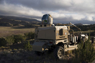
According to Raytheon, its HELWS uses energy to detect, identify, track and take down drones. (Photo: Raytheon)
Raytheon Company will deploy two prototype high-energy laser weapon systems (HELWS) to troops overseas under a $24 million U.S. Air Force contract. The U.S. Air Force’s experimentation includes 12 months of in-field operation against unmanned aerial systems and operator training.
Raytheon’s HELWS uses energy to detect, identify, track and take down drones. According to the company, the system can target a single drone with precision. The HELWS is paired with Raytheon’s Raytheon’s Multi-spectral Targeting System. Raytheon’s HELWS, which comes mounted on a Polaris MRZR all-terrain vehicle, uses invisible beams of light to defeat hostile unmanned aerial systems.
“Every day, there’s another story about a rogue drone incident,” said Stefan Baur, vice president of Raytheon Electronic Warfare Systems. “These threats aren’t going away, and in many instances, shooting them with a high energy laser weapon system is the most effective and safest way to bring them down.”
Raytheon, headquartered in Waltham, Massachusetts, is a technology and innovation company that specializes in defense, civil government and cybersecurity solutions.
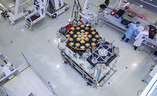
Galileo is on the march with a new generation of satellites bearing improved atomic clocks. The first of the Batch 3 navigation payloads was delivered in June by Surrey Satellite Technology (SSTL) in the UK to OHB System AG in Bremen, Germany.
SSTL’s payload for Batch 3 is a recurrent build of the existing FOC payload, with an evolution of the atomic clocks to incorporate advances made under the European GNSS Evolution Programme. The earlier SSTL Galileo FOC payload comprised different units including European-sourced atomic clocks, navigation signal generators, high power traveling wave tube amplifiers and antennas.
The new payload will be integrated aboard the satellite platform Galileo FOC FM23, named Patrick in honor of the winner of a drawing competition. Payload integration will be followed by a series of comprehensive test activities. Patrick and its next youngest sibling satellite of this series are scheduled to be ready for launch in autumn 2020.
“We are looking forward to this first ‘marriage’ of a Batch-3-payload and platform and are ready to start Patrick’s test sequence soon,” said Lars Peters from OHB System AG, in charge of the Assembly Integration and Test for the satellites at eleven production islands where one satellite is completed every five weeks.
“The ambitious schedule means that looking forward reserve satellites will be available both in orbit and on the ground,” added Dr. Wolfgang Paetsch, a member of the OHB System AG Management Board responsible for navigation, Earth observation and science.
“Of course we are waiting a bit to see what the real lifetime of the satellites is going to be. We don’t know that yet but we will find out in the next couple of years. Obviously there is a lot of pressure for further innovation, for further improvements. The user community over the last couple of years has become more outspoken about what they want and what they expect, which is nice. Obviously we need to take care of the legacy users, and we are having to see what new technology would allow us to do.”
OHB System AG has contracted to deliver a further twelve satellites of this Batch 3 for Galileo. This will bring to 34 the number of Galileo satellites being supplied by the SSTL-OHB partnership. Of these, 14 are already in orbit.
Feature photo: The satellite Patrick, first of Galileo’s Batch 3, will eventually travel from OHB to ESA’s ESTEC technical centre (shown here) in Noordwijk, the Netherlands for rigorous testing in simulated space conditions. (Photo: European Space Agency)
Microsemi has released its TimeProvider 4100 Release 2.0, the latest version of its TimeProvider 4100 precise timing grandmaster.
The TimeProvider 4100 is a grandmaster complemented by extensive port fan-out for PTP, Network Time Protocol, sync and legacy building integrated timing supplies. According to the company, the TimeProvider 4100 offers multiple ports for current, legacy and future networks that can be connected to multiple base stations for 4G and 5G deployments.
Microsemi launched its TimeProvider 4100 Release 2.0, the latest version of its TimeProvider 4100 precise timing grandmaster. (Photo: Microsemi)
Version 2.0 of the TimeProvider 4100 includes a number of new features, including an optional expansion module with 10GE support for 1G/10G/100M fan-out, offering four SFP and four SFP+ ports; increased capacity to 790 PTP clients (up from 512 previously) at a full rate of 128 packets per second; a boundary clock that supports Class C and class D; support for Primary Reference Timing Clock Class B (ITU-T G.8272); and support for multiple operation modes.
The unit can still behave as a fully functional grandmaster from an outputs standpoint and also has the capability to monitor various kinds of inputs, the company added. It also features a new operation mode for a high-performance boundary clock.
According to Microsemi, TimeProvider 4100 Release 2.0 adds support for PRTC-B in addition to PRTC-A. In addition, it adds support for monitoring presentation through Microsemi’s TimePictra 10 synchronization management system.
Terra Drone Europe, a group company of Terra Drone Corporation, has completed an aerial 3D survey and produced a 3D model of an offshore oil rig platform in the North Sea for Shell.
According to Terra Drone Europe, the platform complex that was surveyed was positioned several years ago when GNSS survey techniques were neither very advanced nor common. Several coordinates were known and as-build drawings were available, but Shell wanted to know the position of each and every element on the platform to facilitate accurate drill rig positioning.
Terra Drone Europe completed an aerial 3D survey and produced a 3D model of an offshore oil rig platform in the North Sea for Shell. (Photo: Terra Drone)
Thus, the company recruited Terra Drone Europe to capture the as-is conditions through a high-precision oil rig platform survey. According to Terra Drone, the survey was divided into two parts: one part dedicated to creating a 3D point cloud and the second to accurately check the position of the platform using GNSS readings.
Two GNSS receivers were installed at several different locations on each platform and used to log in the raw data which was later processed. When this data was combined with the 3D point cloud created by Terra Drone Europe, the coordinates of each asset on the platform structure were determined.
Terra Drone Corporation recently established new branches focusing on the oil and gas sector in Argentina, Angola, Kazakhstan and the United Arab Emirates. The company also formed a new branch to provide advanced nondestructive testing and inspection services to the oil and gas industry.
Government agencies are increasingly turning to high-precision aerial imagery to solve city-planning conundrums. Three recent case studies show how emergency 9-1-1 services gather data to provide updated maps to emergency services to get to the right locations as soon as possible; reveal how a city’s public works department streamlines data collection for more efficient infrastructure management; and how to give GIS professionals instant access to the most current information available — all in the cloud.
Photo: Nearmap
It’s said a picture is worth a thousand words. In the case of aerial imagery, where location data is packed into every pixel, a picture could save lives.
Emergency dispatch is just one type of government agency now relying on high-quality aerial imagery. With up-to-date georeferenced imagery of their own towns and counties, agencies are not only improving response to emergency calls, but also streamlining public works and enhancing city planning.
A company providing that imagery is Nearmap, which serves more than 8,200 organizations and businesses globally using small aircraft for image capture. The aerial mapping company provides high-quality imagery as a subscription service delivered through the cloud. Its photo maps are taken at least twice a year, with leaves both on and off the trees, to provide different views of locations in different seasons.
Nearmap’s patented camera system and software pipeline enables it to capture aerial photos, stitch them together into seamless digital maps, and publish the content online within days of capture. Above, Nike’s headquarters in Portland. (Photo: Nearmap)
Aircraft offers a huge advantage over unmanned aerial vehicle (UAV) or satellite imagery. Airplanes can cover much greater distances than UAVs, and pilots pay heed to the weather and fly below cloud layers to deliver the clearest visuals possible. Unlike space-based platforms, airplanes operate at lower altitudes, also increasing the resolution, and can fly on demand, unlike satellites that have set orbits dictating their periodicity for returning to a target area.
Nearmap’s powerful, patented technology allows it to deliver high-resolution aerial imagery as a service: orthographic (straight down) maps, multi-perspective panoramas and oblique aerial views — all at resolutions four times clearer than free satellite imagery.
Once photographed, the images are stitched together in the cloud in a matter of days, where they are available for viewing and analysis on desktop, tablet and mobile devices via a subscription service.
Nearmap’s proactive capture model is based on population — the larger the population, the more captures it takes per year. Nearmap images 88% of Australia’s population, 70% of the U.S. population, and 75% of the New Zealand population.
Nearmap captures many areas multiple times throughout the year; for many locations this gives customers a leaf-off and leaf-on view. Providing spring leaf-off captures allows customers a view of the ground that is typically obstructed by foliage the rest of the year.
The flight plans cover approximately 430 urban areas that are flown, captured and processed, and then served up via the MapBrowser in-browser tool, or supplied via application programming interface (API) for use in various design platforms. When a user subscribes to Nearmap, the capture is immediately available with any and all historical captures, without the need to pay for a dedicated flight.
“To capture imagery for a map, a plane has to crisscross over its own flightpath. Each sweep has to overlap the previous by approximately 70%,” explained William Tewelow, GPS World’s contributing editor for geointelligence. “Vertical (or nadir) is straight overhead. Oblique is everything else, but usually not exceeding 30% to either side because it distorts the structures and vertical features (parallax), makes mosaicking difficult, and shadows structures behind other structures.”
That said, oblique imagery is important for building 3D meshes for imagery point clouds, Tewelow said, as well as seeing various angles of a structure.
Following are examples of the creative — and surprising — ways government agencies are using Nearmap imagery to improve their services today, and prepare for future changes in their communities.
Better 9-1-1 address mapping
Shelby County is the largest county in Tennessee in both population (927,644) and geographic area (785 square miles). Memphis is the county seat, home to the county’s Emergency Communications District, for the operations of the local 9-1-1 emergency system.
The district provides Shelby County residents with an efficient emergency telephone number service using the latest technology, equipment and training for the various emergency service providers and dispatch centers.
For each dispatch center, the district provides county address location mapping. A secure database known as an ALI (Automatic Location Identification) contains the exact 9-1-1 address for any given associated phone numbers.
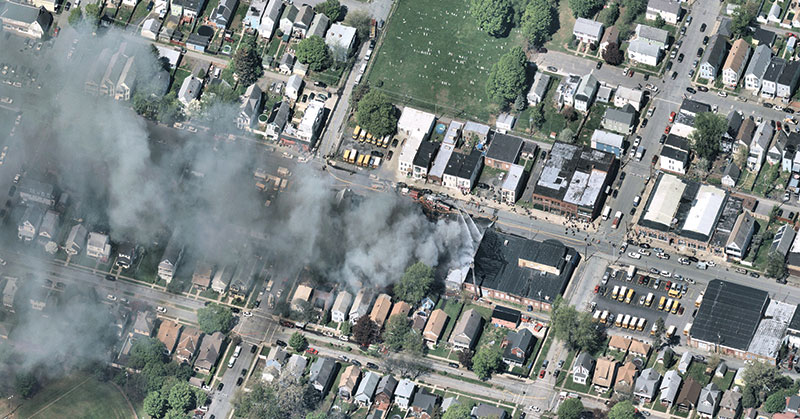
Albany, N.Y.: A house fire in progress. (Photo: Nearmap)
When a 9-1-1 call comes in, the database is queried by the Public Safety Answering Point to obtain the caller’s location. This data is then placed in the computer-aided dispatch software and 9-1-1 mapping software used by the district to help fire and rescue, emergency medical services and law enforcement gain instant access to updated maps containing GIS data needed to get to the right locations as soon as possible.
The 9-1-1 mapping system uses geodetic coordinates to plot wireless calls on the map. The system also reverse geocodes the coordinates to provide the 9-1-1 telecommunicator with a calculated civic address based on proximity of other features in the map, such as address points or streets.
Out-of-Date Imagery. For years, Shelby County’s aerial image process required a contracted flight to photograph the county areas. Because of the high cost of capturing those images, the county purchased images once every two years, after pooling resources from various county entities.
“We had gaps where we wouldn’t have updated imagery,” said Timothy Zimmer, the district’s GIS administrator. “While the images were high resolution, there were issues with mosaicking the separate images together, and since the imagery was taken every two years, many rural and unincorporated areas were out of date.”
With out-of-date images, the county had to develop alternate methods to locate addresses for the 9-1-1 systems.
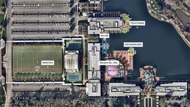
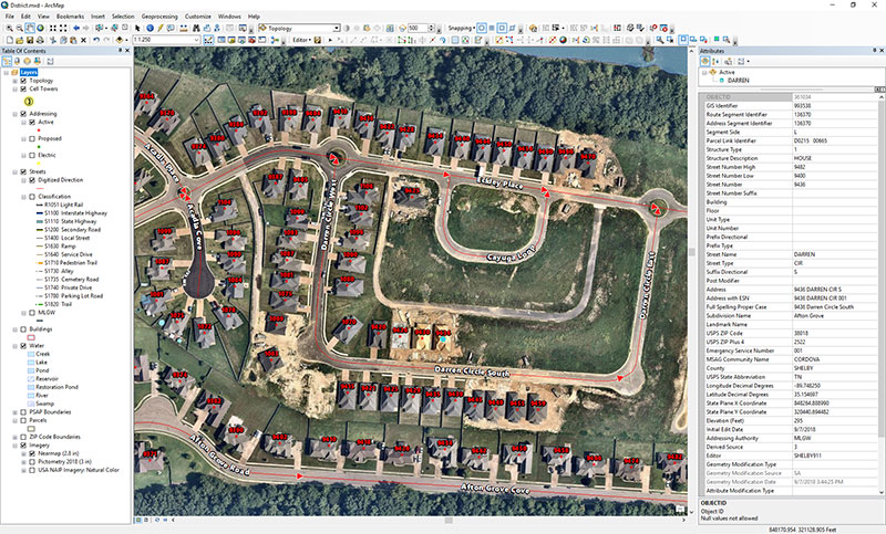
Moving into the Cloud. In the summer of 2018, Zimmer began to work with Nearmap. With Nearmap, Zimmer and his team can access current imagery to geocode new addresses and developments as well as plot new roads into the 9-1-1 mapping systems (Figure 1).
For Zimmer, the biggest advantage is that Nearmap’s imagery integrates directly into Esri’s ArcMap, ArcPro and ArcGIS Online applications, so he can overlay GIS information directly over the high-resolution imagery.
“I really like how Nearmap is integrated into the GIS stack,” Zimmer said. “We’re able to stay on top of new developments, roads, and addresses. Being able to have Nearmap imagery integrated into our GIS systems helps us be much more accurate.”
The combined impact of data services, base maps, Nearmap imagery and third-party data are improving all aspects of public safety, including law enforcement, fire and emergency medical services.
Other Shelby County agencies also are using the district’s imagery and GIS data. “The county clerk and the utility company are using our address mapping data because Nearmap has helped enable us to be much more current,” Zimmer said.
Public works in a fast-growing city
Durham is one of the points in North Carolina’s high-tech Research Triangle and home to Duke University.
An economic and cultural renaissance is happening in the city. With a revitalization of its downtown district, the redevelopment and repurposing of former tobacco districts into tech hubs, and chic loft-style apartment complexes, Durham is rapidly growing beyond its most recently reported 250,000 population numbers.
Impervious Challenge. In early 2018, the city’s growth explosion prompted Edward Cherry, GIS administrator for the City of Durham Public Works Department, and his staff of 14 GIS professionals to seek ways to streamline their data collection.
The department manages all infrastructure data for the city, including mapping the impervious area. As defined by the U.S. Geological Survey, impervious surfaces include highways, streets, pavement, driveways and even house roofs — any surface that won’t absorb rainwater. Rather, the rain runs off into storm sewers and then into local creeks; localized flooding is often the result.
Durham Public Works manages half a billion square feet of impervious area. The city’s $16 million-a-year Stormwater Utility Fee income was a driver for Cherry’s team to explore satellite imagery options. Imagery from satellites, however, were infrequent and too low-resolution to meet their needs. The satellites captured images only once-a-year, and that might be on a cloudy or rainy day. Clouds cast shadows, and rain makes pavement appear newer than it is.
Nearmap’s aerial imagery, captured in Durham three times a year at a 2.8-inch ground sample distance (GSD), solved the problem (the GSD of each individual pixel in the imagery represents 2.8 inches on the ground. See Figure 2).
Figure 2: Rapid growth requires frequent imagery. Above is a new Durham neighborhood under construction. (Photo: Nearmap)
Dozens of projects in the Public Works Department — from road maintenance and pothole patching to water sampling and degradation — are using the improved imagery, which has saved the city money, reduced time spent in the field, and allowed crews to use real-time imagery when they are working in the field.
Monitoring Pavement Conditions. The City of Durham is responsible for maintaining most of its roads, and conducts a road-condition survey that samples different sites, evaluating the level of degradation.
Since 2014, Nearmap has regularly captured Durham streets at the same resolution and accuracy, and both the historical and current data are available to the department. With multiple high-quality image captures at high resolution, surveyors can see sections that have been recently paved. “We don’t need to send crews out to an area where a stretch has already been paved,” Cherry explained.
Road Repair Documentation. As in any city, the patching of potholes is an ongoing project for Durham’s public works department. With imagery, the city has been able to streamline the process.
Traditionally, the streets department sent out inspectors to spray paint and circle areas that required repairs. “Then we would produce maps and hard copies to direct [road repair contractors] ahead of time on a scheduled event,” Cherry said.
Now the city uses an application integrated with Nearmap imagery by which contractors can view the job on their smartphone or tablet while in the field. The surveyors can edit and draw the areas that need patching instead of physically going out and spray-painting them. “Then, in real time, the people doing the patching can see a very high-resolution image of where they need to do the work,” he said.
The pothole image captures are recorded, so the city knows where and how many potholes were patched. “We can see where work has been done when we are billed for it,” Cherry said. “We can visualize the work, which is an added bonus.”
Mapping Riparian Zones. With imagery previously taken only when the leaves had fallen (known as leaf-off), surveys of riparian zones in Durham proved limiting.
With imagery captured during both leaf-off and leaf-on seasons, riparian buffers around streams can be properly monitored for expansion. The buffers can be altered if there are issues with a stream’s path, such as sediment clogging the flow, repeated flooding or people intruding on a buffer.
Change Detection. High-resolution imagery has improved Durham’s billing process by producing web service maps that capture individual storylines. Stormwater billing customers, for instance, can visualize their properties with the impervious areas mapped out and tied to their billing records.
With up-to-date imagery providing data for change detection software, records also show when a customer has added a driveway or an extension to their house.
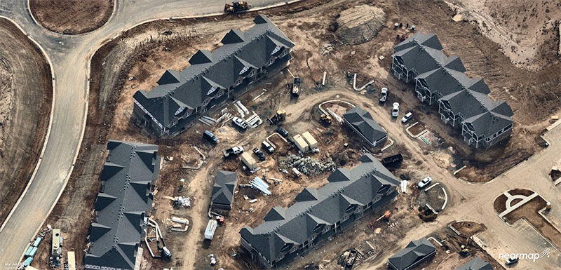
Figure 3: Aerial Imagery of an Apex neighborhood displayed in ArcGIS from Esri. (Image: Nearmap)
“Having access to imagery back to 2014, we’re able to go back in time during the thrust of development and monitor it forward,” Cherry said.
Nearmaps’ library of historical imagery allows for change detection algorithms to run in Esri’s ArcGIS imagery analysis software suite.
More efficient government
GIS data combined with aerial imagery is tailor-made for city planning and managing urban growth.
For instance, the population of Apex, N.C., has more than doubled since 2000. Situated near Raleigh and the state’s Research Triangle Park, Apex was rated number one in Money magazine’s 2015 “Best Places to Live,” which cited Apex’s charming downtown, highly rated schools and high-paying technology jobs.
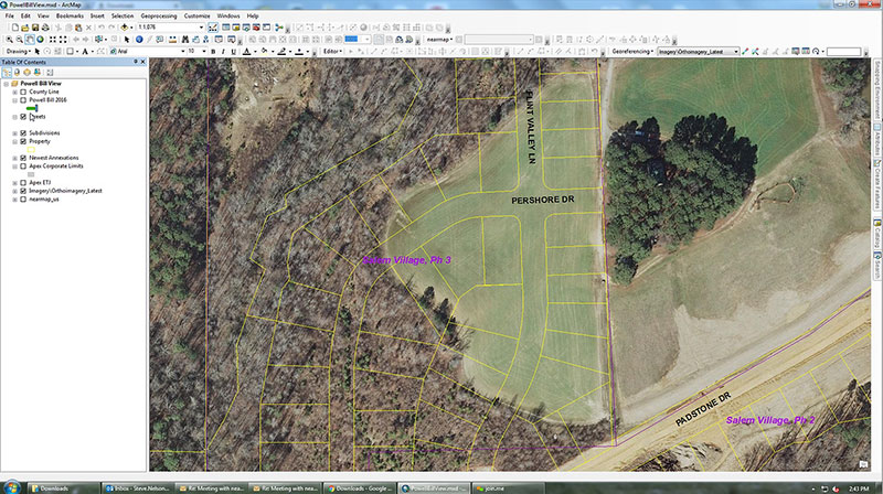
Figure 4: The post-construction image of the same neighborhood is much more accurate. (Image: Nearmap)
To manage the explosion in development, Apex’s GIS professionals needed instant access to current information. The old-school method required planners to drive the streets, inspect roadways, and roll out the measurement wheel. Now, the combination of Esri ArcGIS for mapping and Nearmap high-resolution aerial imagery allows them to visualize and measure within six inches of accuracy.
“Our ability to leverage our GIS operation improved dramatically with Nearmap. The flexibility of its cloud solution and ability to integrate with ArcGIS has redefined how we rapidly respond to staff and citizen requests,” said Steve Nelson, a GIS professional with Apex.
The use cases for these solutions are diverse. Law enforcement calls on GIS professionals from Apex to quickly provide current, clear, aerial photography for active or ongoing investigations. Planners focused on development are charged with meeting state regulatory reporting guidelines when it comes to building and maintaining roads. Environmentalists want to know if anyone is digging on protected land.
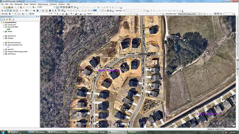
Figure 5: Measuring for reimbursement in Apex. (Image: Nearmap)
For the State Street-Aid Program, financial allocations are made to incorporated municipalities eligible under North Carolina law. State routes that pass through incorporated cities are maintained by the cities. Cities are responsible for paving new roads, but the state has the power and economic means to reimburse them.
To qualify for reimbursement for new roads developed and maintained, Apex needs to submit a report to state engineers for review. The report documents the distance for all newly paved roads.
Before the new system was in place, GIS professionals had access to imagery from 2013, but the actual development took place after this. In (Figure 3), the 2013 imagery simply outlines the parcels and rights of way. It has no detail with respect to where the roads start and end, so a lot of field work was needed to take measurements, drive roads scattered across the county, and collect data.
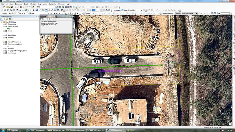
Figure 6: Green lines indicate new streets in Apex in a single year (2013). (Image: Nearmap)
With the new system, workers have instant access from their desktop to the same location as it currently is. They can see exactly where the edge of the road starts and stops (Figures 4 and 5), which is different from the yellow-lined “right of way” depicted in Figure 3. While in the office, GIS professionals can measure distances precisely, creating an accurate representation of ground truth.
Figure 6 highlights a small portion of new roads built in Apex in one year. The green lines highlighted are scattered across the city. As Apex continues to grow and annex adjacent territory, the dynamic nature of the growth will be captured and uploaded to the cloud.
Unlocking Potential
As cities grow in complexity, mapping becomes integral to planning. With the advances aerial imagery provides, cities are starting to unlock the full potential of location data and visualizing a better future.
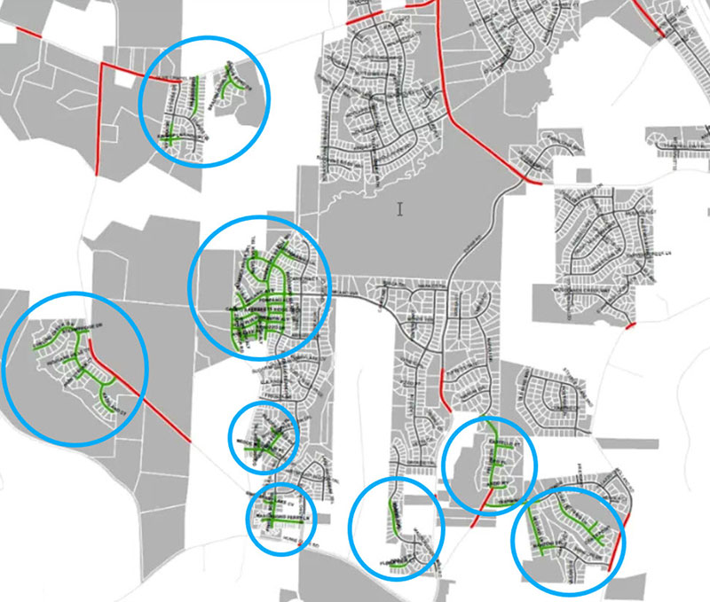
Small towns and cities face tight budgets for operating and maintaining public utilities. By sharing resources for common activities, a city can improve cost efficiency in its gas, electric, water and sewer services. In southern Minnesota, the city of New Ulm has modernized its approach to utility asset location and identification management. The effort is reducing costs and improving service for its 13,000 residents.
For more than a decade, the New Ulm Public Utilities group used a computer-aided design (CAD)-based system to track assets for six different utilities. After evaluating its approach for asset mapping, the city transitioned to a geospatial information system (GIS) which provided an opportunity to streamline data collection and management across all of the city-owned utilities.
The city turned to the Trimble Positions Desktop add-in software for Esri ArcGIS Desktop. The approach enables New Ulm field technicians to use Trimble TerraSync field software and Trimble Geo 7X GNSS handhelds for data collection for utility assets and then process the GNSS data in Trimble Positions Desktop. Using this method, the city can provide customized field workflows needed by the different utilities while delivering completed information to a single, centralized GIS database.
In addition to recording the locations and attributes of utility assets, the Trimble solution helps New Ulm technicians return to specific assets when needed. Using real-time GNSS positioning, field crews can navigate directly to specific assets. “Looking for a shutoff valve during a snowstorm isn’t easy,” said New Ulm GIS technician John Bendix. “The Trimble handhelds help them find an asset quickly.”
Bendix uses the Trimble solution to manage connectivity and geographic relationships for new assets. Assets connected to a feature (such as pipes connecting to a manhole) can be automatically adjusted as needed when new field data is checked into the database.