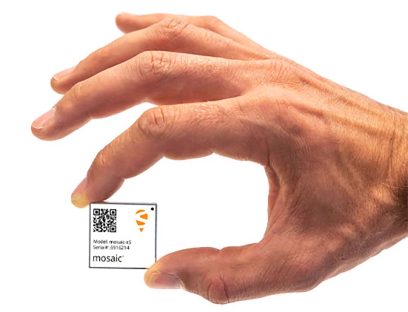
Mosaic is Septentrio’s most compact, next-generation, high-precision multi-frequency GPS/GNSS module. The receiver brings precision and reliability of high-end multi-frequency GNSS to mass-market applications, the company said. It is designed to fit into the assembly-line process, which allows mosaic to be favorably priced for high volumes.
Its lightweight and low power consumption helps extend the battery life of robotic devices, increasing operation time and efficiency. This makes mosaic suitable for applications such as robotics, automation, telematics and wearables.
“We see a growing demand for reliable high-precision positioning,” said Chris Lowet, product manager at Septentrio. “A few years ago, this demand was concentrated in professional applications, for example survey, high-precision mapping and machine control. Today, with expansion of robotics, automation and IoT, a wide range of devices need high-precision positioning, from ag robots to IoT gateways to autonomous vehicles. We designed mosaic to answer these market needs.”
Highlights of mosaic include:
Centimeter positioning in tough environments with multi-frequency, multi-constellation GNSS technology
Extensive corrections support for high-accuracy positioning: SBAS, PPP, SSR, RTK
RAIM+, integrity engine needed for safety-critical applications such as autonomous vehicles
Tracking all current and future GNSS satellite signals for enhanced real-time kinematic (RTK) performance and guaranteed RTK network compatibility
100-Hz update rate, suitable for robotics and fast-moving vehicles.
The development kit assists Septentrio customers with integrating mosaic into their system. It supports connectivity through internet, COM ports, USB 2.0 as well as an SD Card slot. The development kit can be requested here.
A major use of remote sensing data is to compare images of an area taken at different times and identify the changes it underwent. With a wealth of long-term satellite imagery in open use, detecting such changes manually would be time-consuming and most likely inaccurate.
To address this, EOS Data Analytics has introduced an automated Change Detection tool to its flagship product LandViewer, a cloud tool for satellite imagery search and analysis in today’s market.
Unlike the methods involving neural networks that identify changes in the previously extracted features, the change detection algorithm implemented by EOS is using a pixel-based strategy, meaning that changes between two raster multi-band images are mathematically calculated by subtracting the pixel values for one date from the pixel values of the same coordinates for another date.
This new signature feature is designed to automate a change detection task and deliver accurate results in fewer steps and in a fraction of the time needed for change detection in most image-processing software.
Change detection interface: Images of Beirut city coastline selected for tracing the developments of the past years. (Image: LandViewer)Change detection interface: Images of Beirut city coastline selected for tracing the developments of the past years. (Image: LandViewer)
Applications from farming to environmental monitoring
One of the main goals set by EOS team was to make the complex process of change detection in remote sensing data equally accessible and easy for non-expert users coming from non-GIS industries.
With Land Viewer’s change detection tool, farmers can quickly identify the areas on their fields that were damaged by hail, storm or flooding. In forest management, satellite image detection of changes will come in handy for estimation of the burned areas following the wildfire and spotting the illegal logging or encroachment on forest lands.
Observing the rate and extent of climate changes occurring to the planet (such as polar ice melt, air and water pollution, natural habitat loss due to urban expansion) is an ongoing task of environmental scientists, who may now have it done online in a matter of minutes. By studying the differences between the past and present using the change detection tool and years of satellite data in Land Viewer, all these industries can also forecast future changes.
Top change detection use cases: Flood damage and deforestation
A picture is worth a thousand words, and the capabilities of satellite image change detection in Land Viewer can be best demonstrated on real-life examples.
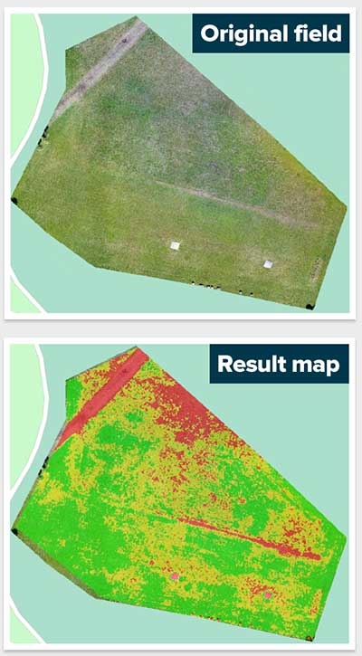
Forests that still cover around a third of the world’s area are disappearing at an alarming rate, mostly due to human activities such as farming, mining, grazing of livestock, logging, and also the natural factors like wildfires. Instead of massive ground surveying of thousands of forest acres, a forestry technician can regularly monitor the forest safety with a pair of satellite images and the automated change detection based on NDVI (Normalized Difference Vegetation Index).
How does it work? NDVI is a known means of determining vegetation health. By comparing the satellite image of the intact forest with the recent one acquired after the trees were cut down, Land Viewer will detect the changes and generate a difference image highlighting the deforestation spots, which can further be downloaded by users in JPG, PNG or TIFF format. The surviving forest cover will have positive values, while the cleared areas will have negative ones and be shown in red hues indicating there’s no vegetation present.
A difference image showing the extent of deforestation in Madagascar between 2016 and 2018; generated from two Sentinel-2 satellite images. (Image: LandViewer)
Another widespread use case for change detection would be agricultural flood damage assessment, which is of most interest to crop growers and insurance companies. Whenever flooding has taken a heavy toll on your harvest, the damage can be quickly mapped and measured with the help of NDWI-based change detection algorithms.
Results of Sentinel-2 scene change detection: The red and orange areas represent the flooded part of the field,; the surrounding fields are green, meaning they avoided the damage. California flooding, February 2017. (Image: LandViewer)
How to run change detection in Land Viewer
There are two ways you can launch the tool and start finding differences on multi-temporal satellite images: by clicking the right menu icon “Analysis tools” or from the Comparison slider ‒ whichever is more convenient. Currently, change detection is performed on optical (passive) satellite data only; addition of the algorithms for active remote sensing data is scheduled for future updates.
A link to the live event will be sent to you two hours before the event. Your personalized event URL will be automatically generated by the ON24 system. To ensure receipt of the email, please whitelist this email address by adding it to your contacts: [email protected].
This presentation will begin on at 1 p.m. EDT / 10 a.m. PDT on Thursday, June 27.
Audience members may arrive 15 minutes prior to live time. If you have any questions, please contact event producer Allison Barwacz at [email protected].
Maptitude for Redistricting is designed specifically for anyone involved in or preparing for the 2020 redistricting cycle, from novice to professional users.
Maptitude for Redistricting 2019 has new partisan competitiveness reports, adds access to imagery layers, and allows users to save and share their plans in a variety of formats.
New features include:
Speed improvements provide faster access to maps and geographic analysis.
Expanded file support for Excel worksheets, Google Earth Documents (KML/KMZ) attribute data fields, and MapPoint files.
New partisan competitiveness reports and measures of compactness for analyzing redistricting plans,
Integrated satellite imagery from a variety of sources for giving a better view of district composition.
The latest Census geography and data, including current ACS data.
Maptitude for Redistricting is a professional tool for political redistricting. It provides measures and reports that support the creation of fair and balanced districts.
Maptitude is constantly enhanced and provides tools such as the Efficiency Gap Measure for exploring redistricting problems.
Maptitude was used to democratize redistricting in California and is used by the majority of redistricters, from independent commissions, non-profits, and civil rights groups, to the courts and political parties.
Intergeo 2019, which is set to take place Sept. 17-19 in Stuttgart, Germany, will cover a number of key geodata topics. The main topics highlighted during the conference will include smart cities, campus geoinnovation, digitalization, building information modeling, emphasis on local authorities and UAVs.
More than 680 exhibitors will be providing insights into the highly dynamic geospatial sector, event organizers added.
“Geodata forms the foundation for our digital society and is thus becoming the currency of the future,” said Hansjörg Kutterer, president of the German Society for Geodesy, Geoinformation and Land Management. “These developments are exciting and our industry is not just affected by them — it is actively shaping them.”
According to event organizers, the show will show what digital change in the field of geoinformation means. Keynote speakers for Intergeo 2019 include Dr. Markus Kerber, state secretary at the Federal Ministry of the Interior, Building and Community; Dr. Juergen Dold, president, of Hexagon’s Geosystems Division; and Hashem Al-Ghaili, director of content at Futurism.
Kerber will cover smart homeland and how digitalization can help achieve equal standards of living. Dold will discuss opportunities through digital business models. Finally, Al-Ghaili will present new ways of communicating science.
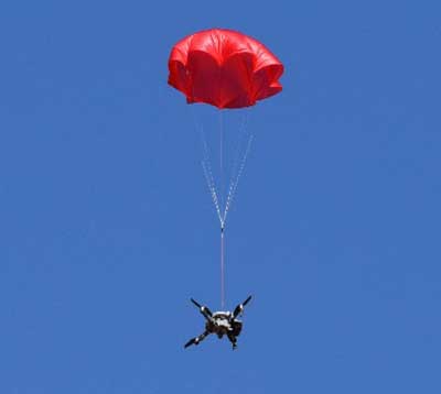
The SafeAir System is a smart parachute system that monitors UAS flight in real time, identifies critical failures, and autonomously triggers a parachute.
The ASTM F3322-18 Standard Specification for UAS Parachutes was designed to enable civil aviation authorities (CAAs), like the Federal Aviation Administration (FAA), to determine whether a parachute system is airworthy for flight over human beings.
Among other requirements, the standard defines more than 45 aerial deployment tests in various failure scenarios, verified by a third party.
ParaZero’s ASTM-compliant SafeAir Mavic is designed specifically for DJI’s Mavic 2 series. The SafeAir System is a smart parachute system that monitors UAS flight in real time, identifies critical failures, and autonomously triggers a parachute. The system contains a flight termination system, a black box to enable post-deployment analysis, and a warning buzzer to alert people below of the falling drone.
Safe UAV flights over people. The completion of the compliance process for the SafeAir Mavic will open the doors for UAS operators that are interested in the possibility of safe and legal UAS operations over people using the DJI Mavic 2. The FAA has granted a waiver for flight over people to an operator using ParaZero’s ASTM compliant SafeAir Phantom.
Photo: ParaZero
The third-party validation provided by NPUASTS — an FAA UAV test site in North Dakota — played a crucial role in the ParaZero testing. The ParaZero project is in line with the work the NPUASTS is doing to promote the safe integration of UAS into the National Airspace System.
The ability to safely operate UAS over people and in urban environments through waivers and approval is important for the growth of the UAS industry.
“Third-party validation of the SafeAir Safety System for the Mavic is a necessary step for the industry to help advance operations of small UAS in various environments,” said Nicholas Flom, NPUASTS executive director. “With the partnership from ParaZero, we are one step closer to realizing routine flight operations over persons on the ground.”
UAS operators can now purchase the ASTM-compliant SafeAir Mavic on ParaZero’s website. UAS operators will also receive compliance documentation with the purchase of the SafeAir Mavic system, including NPUASTS’ third-party testing report. This documentation and report will provide validation that operators can submit to the FAA with an operations-over-people waiver application.
“Following the precedent setting waiver announced earlier this week, we are excited to launch our second ASTM compliant SafeAir System,” said Avi Lozowick, vice president of policy and strategy at ParaZero. “We are lucky to have partners like NPUASTS for this process; their aviation experience is second to none.”
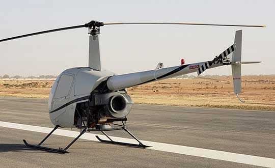
A Robinson R22 helicopter was converted by UAVOS to an unmanned drone. UAVOS — which specializes in the design, development and manufacturing of unmanned vehicles and autopilot systems — successfully completed in-air programmed missions with the unmanned helicopter.
The first flight this spring of the modernized helicopter lasted more than one hour and was performed in a fully self-piloted mode, reaching an altitude of up to 2,200 feet (670 meters). During the flight, all scheduled tests were performed including fully automatic take-off, enroute flight and landing. The tuning of UAV control settings was completed as well.
The converted R22-UV is serving as a platform for research and testing for commercial UAV options. For instance, upcoming test flights will include cargo delivery of up to 330 pounds (150 kg) in automatic mode. Flights with a duration of 6+ hours using additional fuel tanks and a payload for monitoring the land surface are also planned.
Besides that, UAVOS is planning to check operational limitations of the UAV during night flights and flights under severe weather conditions. A top priority is testing the possibility of using spraying equipment and to see whether R22-UV could serve agricultural purposes.
Components installed. The UAVOS components installed in R22-UV helicopter included autopilot, servo drives, sensor system and additional backup power supply. During the conversion, the aircraft electrical system was upgraded, manual control was removed, the fuselage was altered for servo drives and components of the automatic control system installation. In addition, the pilot seats were removed and replaced by additional fuel tanks.
Powered by a gasoline engine, the unmanned R22-UV helicopter is able to deliver cargo or carry payload with a total weight of up to 330 pounds (150 kg) with a maximum take-off weight of 1,400 pounds (635 kg).
Heavy payloads. The converted aircraft has a practical ceiling of 13,780 feet (4,200 meters) and has a top speed of 189 kph. The UAV is designed to carry high-precision, heavy professional equipment 88 pounds (40 kg and more) for a wide variety of missions including lidar, synthetic aperture radar, heavy optical equipment or gas analyzers.
The R22-UV can be operated in the regions without airfields, under severe weather conditions and during night-time, in the conditions with high stress risk for a pilot. The converted helicopter is useful for oil and gas companies that need to deliver cargo to hard-to-reach places, or where chemicals hazardous to humans are spread on the fields and forests. Operational limits for high-altitude flights and missions in heavy turbulence and high mountain regions should be defined after appropriate testing.
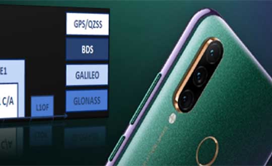
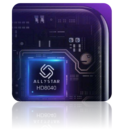
The latest Lenovo smartphone offers dual-frequency GNSS capable of tracking the latest BDS phase III signal, the Z6 SE, using an Allystar chipset.
The company says this is the first time a smartphone supports the new BeiDou signal.
HD8040 series SoC. (Photo: Allystar)
Fitted with a Allystar HD8040 series chipset, the Lenovo Z6 youth edition provides position accuracy up to sub-meter, according to Allystar.
The HD8040 series chipset supports all civil signals on the L5 band. Besides GPS/QZS L5 and GAL E5a, the latest BDS phase III signal B2a has already been implemented to maximize the visible satellites in L5 band.
Dual-frequency GNSS means that the receiver tracks more than one radio signal from each satellite on different frequencies — GPS L1 and L5, Galileo E1 and E5a, and Beidou B1 and B2a.
B2a will replace B2I and broadcast on MEO and IGSO satellites. The code lengths are 10230, which have better anti-cross-correlation performance and are designed separated pilot component and data component to improve tracking sensitivity.
In general navigation scenarios, multipath error lead to positioning inaccuracy of up to several meters, caused by to signals bouncing off of higher buildings. The error caused by multipath can be nullified and mitigated by using two frequencies instead of one in urban areas. Under a relatively open-sky environment, measurement error caused by the ionosphere is usually eliminated by a linear combination of dual frequencies to easily achieve sub-meter accuracy.
“Allystar is glad to boost the smartphones and Internet of Things (IoT) applications with the latest multi-frequency GNSS SoC (system on chip) technology,” said Shi Xian Yang, the product and marketing manager in Allystar.
Lenovo smartphone Z6 SE has Allystar inside. (Photo: Lenovo/Allystar)
No purchase necessary to participate. A purchase or donation will not increase your chances of winning. Participants must be legal residents of the United States and 18 years or older. Void where prohibited.
Official Rules
Sweepstakes begins Saturday, June 1, 2019. Sweepstakes ends Sunday, June 30, 2019. (the “Entry Period”).
How to enter: To participate in the 2019 GPS World State of the Industry survey, entrants must submit an online form located above during the Entry Period. One entry per person. Contact information is the only mandatory information needed to enter. Completing the surveys does not increase your chances of winning. If you do not wish to participate in the survey but would still like to be considered for a prize, please email GPS World’s editor at [email protected] with the subject line “2019 State of the Industry Survey” and include your full name, e-mail address and postal address in the email.
Eligibility: The Sweepstakes is open only to individuals who are legal residents of the fifty (50) United States (including the District of Columbia). You must be 18 years of age or older to be eligible for the Sweepstakes. Employees of North Coast Media, the parent company of GPS World, those involved in the production, development, implementation or handling of the Sweepstakes, any agents acting for, or on behalf of the above entities, their respective parent companies, officers, directors, subsidiaries, affiliates, licensees, service providers, prize suppliers and other person or entity associated with the Sweepstakes and/or the immediate family (spouse, parents, siblings and children) and household members (whether related or not) of each such employee, are not eligible. All U.S., federal, state and local laws and regulations apply. Void in Puerto Rico and where prohibited by law.
Prizes:
Two (2) participants who submit a survey form during the Entry Period will be randomly selected to receive a $100 gift card.
Agreement to Official Rules: Participating in the Sweepstakes constitutes the entrant’s full and unconditional agreement and acceptance of these Official Rules as well as North Coast Media’s Privacy Policy (http://northcoastmedia.net/ncmprivacy.html), which is final and binding. Winning a prize is contingent upon fulfilling all requirements set forth herein. Registrations become the property of North Coast Media. In the unlikely event North Coast Media encounters technical or equipment failures such as telephone network lines failing, computer online system failing, servers and/or provider services cease to be available, or human error in connection with the registration form, etc., North Coast Media will not be held responsible. Collection and handling of personally identifiable information will be in accordance to the Privacy Policy.
Any attempt to exceed the maximum number of entries, whether through use of multiple email accounts or any automated system may result in disqualification. North Coast Media reserves the right to disqualify entrants under suspicion of violations against the terms of Entry. North Coast Media is not responsible for lost, late, incomplete, invalid, altered, unintelligible or misdirected entries, which will be void. In the event of a dispute as to who submitted an entry, the person demonstrating to North Coast Media’s satisfaction, as determined in North Coast Media’s sole discretion, that he or she is the authorized holder of the email account will be deemed to be the entrant. The “authorized holder of the email account” is the natural person assigned by an Internet access provide, online service provider, Internet service provider or other similar organization referencing email address used to post the comment.
Selection of Winners: On July 1, 2019 North Coast Media will select the names of two (2) $100 gift card prize winners in a random drawing of all eligible entries via the GPS World State of the Industry survey forms received during the Entry Period. The odds of being selected as a potential winner depend on the number of eligible entries received during the Entry Period. The potential winners will be contacted via email and asked to provide their full name, age, and mailing address for eligibility within a specified time period. If the potential winner does not respond within the timeframe stated in the notification email, North Coast Media may select an alternate potential winner in his/her place at random from all entries received during the Entry Period.
Requirements of the Potential Winner: The potential winner will be required to return an email to North Coast Media with the winner’s full name, and a valid mailing address. This email and document will affirm eligibility and liability/publicity release within seven (7) days of being notified. If a potential winner fails to return the email confirmation within the required time period, an alternate entrant may be selected in his/her place in a random drawing of all entries received. Acceptance of a prize constitutes consent to use winner’s name and likeness for editorial, advertising and publicity purposes without additional compensation, except where prohibited by law. Failure to comply with any term or condition in these Official Rules may result in disqualification at North Coast Media’s sole discretion.
General Conditions: North Coast Media reserves the right to cancel or suspend the Sweepstakes should – including but not limited to – virus, bugs, unauthorized human intervention, or other causes beyond the control of North Coast Media, corrupt the administration, security, fairness, integrity, or proper operation of the Sweepstakes. Any attempt by any person to undermine the legitimate operation of the Sweepstakes may be a violation of criminal and civil law, and, should such an attempt be made, North Coast Media reserves the right to seek damages from any such person to the fullest extent permitted by law. North Coast Media’s failure to enforce any term of these Official Rules shall not constitute a waiver of that provision.
Release and Limitations of Liability: By entering, participants release and hold harmless North Coast Media Media, respective parent, subsidiaries, affiliates, directors, officers, employees and related entities (collectively, “Releases”) from any and all liability, claims or actions of any kind whatsoever for injuries, damages or losses to persons and property that may be sustained in connection with the receipt, ownership, or use of the prize from or arising out of participation in this Sweepstakes. North Coast Media assumes no responsibility or liability for any error, omission, interruption, deletion, defect, delay in operation or transmission, communications line failure, theft or destruction or unauthorized access to, or alteration of, entries; and/or any incorrect or inaccurate information, whether caused by entrants, printing errors or by any of the equipment or programming associated with or utilized in the Sweepstakes; and/or any problems or technical malfunction of any telephone network or telephone lines, computer on-line systems, servers, or providers, computer equipment, software, failure of any e-mail or entry to be received by North Coast Media due to human or technical error at any web site, or any combination thereof, including any injury or damage to participant’s or any other person’s computer relating to or resulting from participation in the Sweepstakes or use of the prize.
List of Winners: To request winners’ names, send a self-addressed, stamped envelope to: North Coast Media, 1360 E. 9th Street, 10th Floor, Cleveland, OH 44114. Requests must be received by July 5, 2019.
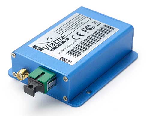
ViaLiteHD Blue OEM module, one of the available formats for the GPS RF over fiber link. (Photo: ViaLink)
Carrying timing signals over optical fiber links to 10+ km, ViaLite’s new GNSS/GPS Fiber Extension Kit has been successfully qualified for use with Microsemi’s timing and synchronization products.
Included in the kit is the ViaLiteHD GPS Link, which is designed for providing a remote GNSS/GPS signal or derived timing reference to equipment located where there is no reception, such as inside buildings, tunnels and mines.
ViaLite designs and manufactures RF over fiber links/systems, support modules, rack chassis and outdoor enclosures. It is a division of Pulse Power & Measurement.
The kit is suitable for GPS, Galileo, GLONASS and BeiDou bands, and the links provide a wide dynamic range with negligible signal degradation from noise or interference.
ViaLite worked closely with Microsemi engineering and product management teams to create the optimized extension kit. Simple single-link extensions are available from both Microsemi and ViaLite, and more complex distributed systems can be defined and supplied by ViaLite.
“We are honored to have been selected by Microsemi as a global supplier for GNSS fiber-optic link equipment,” said ViaLite director of sales Craig Somach.
Microsemi provides synchronization services that assist customers with the planning, deployment and maintenance of synchronization infrastructure.
Their systems need to meet various levels of redundancy, provide multiple timing and frequency outputs, and apply the most accurate GNSS and satcom techniques for measuring offsets between geographically dispersed clocks.
The systems are employed across a wide range of industries, including communications, data centers, aerospace, defense, industrial, financial services, government, oil and gas, power and transportation.
A roundup of recent products in the GNSS and inertial positioning industry from the May 2019 issue of GPS World magazine.
OEM
Signal Analyzer
Tests gnss-disciplined oscillators
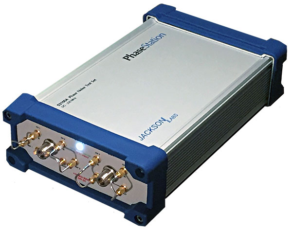
Photo: Jackson Labs
The PhaseStation ADEV Frequency Stability phase noise test system is a new signal source analyzer. It tests signal performance in a host of products such as GPS- or GNSS-disciplined oscillators. It can also be used to qualify and evaluate local oscillator performance for GNSS receiver design, including GPS TCXO evaluation and parametrization, or to take stability measurements of 1PPS and arbitrary frequency outputs from GNSS receivers. It is also useful in optimization of GNSS receiver Kalman filter design via the GNSS receiver 1PPS output signals. It automatically synchronizes and syntonizes (calibrates) the internal dual oscillator DOCXO option to external GNSS receivers via 1PPS input. Jackson Labs, jackson-labs.com
‘Vested’ Tracker
Line for LTE, IoT, child safety
Photo: WTS Positioning Solutions
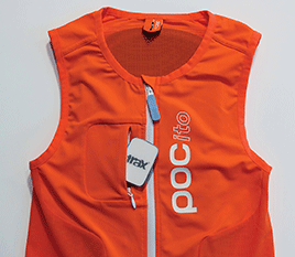
The Trax G+ personal GPS tracker has real-time tracking capability with update rates up to every 10 seconds. For customised industrial applications, the new Trax G+ can support up to two updates per second. It also comes with wireless charging and IP68 water resistance. The Trax G+ 4G LTE-M supports 4G LTE-M and NB-IoT standards, with both European and U.S. models available. The Trax G+ app offers unlimited geofences, augmented reality tracking, speed alerts, location history, the possibility to track multiple devices and device sharing. A special collaboration with POC sports brand resulted in the POCito VPD Air Vest + TRAX. The vest provides a child with back protection for winter sports and is designed to store a TRAX POC Edition device. WTS Positioning Solutions, trax.business
Multi-GNSS module
Supports civil signals on the L5 band
Photo: Allystar
The TAU-0707 is a multi-band, multi-GNSS module series. Within its 7.6 x 7.6 millimeter size, the TAU-0707 supports GPS, Galileo, GLONASS, BeiDou, QZSS, IRNSS and all civil bands (L1, L2, L5, L6). The module is a concurrent multi-band receiver embedded with a Cynosure III single-die standalone positioning chipset, which offers multi-frequency measurements and simplifies integration for third-party applications. The TAU1206-0707 and TAU1205-1010 models are better in multipath mitigation due to the higher chipping rate of L5 signals relative to L1 C/A code. For professional applications, module TAU1303-0707 comes with built-in support for standard RTCM protocol (MSM), supporting multi-band multi-system high-precision raw data output, including pseudorange, phase range, Doppler, SNR for any kind of third-party integration and application. Allystar Technology, www.allystar.com
Open-source receiver
Offers GNSS for the enthusiast
Photo: Amungo Navigation
NUT2NT+ is an open source, multi-frequency, multi-signal, front-end GNSS receiver board built around the NT1065 chip. The receiver has been specifically created for satellite navigation enthusiasts. The NUT2NT+ hardware and software solution offers user the ability to set a receiver’s modes and frequencies, to capture all signals continuously, and to have complete control over primary processing features. The receiver is available via the Crowd Supply website. Amungo Navigation, www.amungo-navigation.com
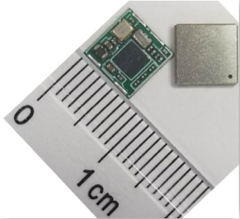
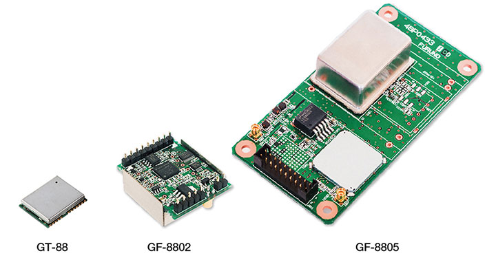
5G GNSS receivers
For UTC time synchronization
Photo: Furuno
The GT-88 timing module and GF-8801/02/03/04/05 disciplined oscillator are for users who require UTC time-synchronized signals (1 PPS/10 MHz) to meet the new 5G requirements. Achieved stability is better than that of an atomic clock, including rubidium. The GT/GF-88 series includes an algorithm, Dynamic Satellite Selection, that provides outstanding multipath mitigation in urban canyon environments. It support GPS, GLONASS, QZSS and Galileo. Furuno Electric Co. Ltd., furuno.com
SURVEY & MAPPING
Machine control
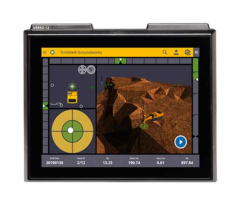
System improves safety, speed for drilling and piling contractors
Photo: Trimble
The Groundworks Machine Control System enables contractors to perform drilling and piling operations with centimeter-level accuracy. Using a touchscreen display, operators can personalize the interface with configurable views. The software aligns with other solutions in the Trimble Civil Engineering and Construction portfolio. Stakeless navigation reduces rework and decreases the need for personnel working near the machine during operation. Contractors can drill to the specified location, depth, orientation and inclination angle. Better rock fragmentation and lower hauling costs can be achieved by optimizing drill-hole spacing, angles and the location of the machine for a more even blasting pattern. Auto stop reduces overdrilling. Automated quality assurance and quality control reporting includes capture of start and end positions, time, elevation and actual embedment depth. Trimble, www.trimble.com
Survey software
Improved for UAV use
Photo: Virtual Surveyor
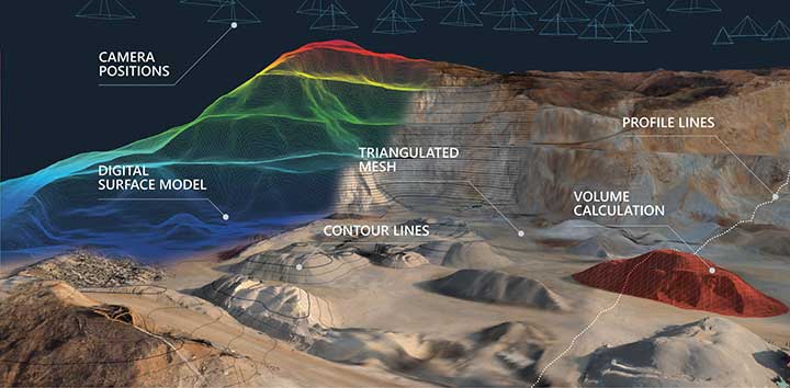
Virtual Surveyor now enables users to process larger projects without buying more powerful computers or cloud services. Version 6.2 solves the problem of large files by offering enhanced clipping and mosaicking functionality. Users can merge multiple processed pieces of orthophotos and digital surface models into a single project, and create smooth edges with the new clipping tool. The mosaic can then be exported to a new TIFF file or serve as the basis for a full area virtual survey. A 3D Fly Through capability allows users to select spatial bookmarks and waypoints and create a movie that allows the viewer to fly through the terrain. Virtual Surveyor, virtual-surveyor.com
GNSS Receiver
Tilt compensates for out-of-plumb measurements
A surveyor checks an urban construction project. (Photo: Topcon)
The compact HiPer VR features advanced GNSS in a rugged IP67 design. Its GNSS chipset has Universal Tracking Channels Technology that automatically tracks every satellite signal (GPS, GLONASS, Galileo, Beidou, IRNSS, QZSS, SBAS). It also has an integrated 9-axis IMU and 3-axis eCompass. TILT (Topcon Integrated Leveling Technology) is designed to compensate for mis-leveled field measurements out of plumb by as much as 15 degrees.The HiPer VR can be used for static or kinematic GNSS post-processed surveys, as a network RTK rover with the FC-5000’s internal 4G/LTE cellular modem, as a UHF/FH/Longlink jobsite RTK rover, and also in Topcon’s patented Hybrid Positioning workflow. Topcon Positioning Group, topconpositioning.com
Mobile laser scanner
With NovAtel and Velodyne
Photo: Lidaretto
Lidaretto is a flexible mobile laser scanner for aircraft, land vehicles or on foot. Combining high-end technology by Velodyne and NovAtel, Lidaretto produces highly accurate point clouds for professional applications such as mapping, surveying, GIS and inspection. The NovAtel OEM7 receiver provides 555 channels, and is SPAN-enabled and optionally dual GNSS. Signals received include GPS+GLONASS L1 and L2; the receiver is upgradable to Galileo and BeiDou. Accuracy is achieved to 1–2 centimeters. Lidaretto, www.lidaretto.com
Processing software
For land surveying
Photo: 3Dsurvey
3Dsurvey version 2.0 is a software ecosystem for land surveying data processing. Users can take photos with any standard digital camera, import images into 3Dsurvey, and produce their own orthophoto maps and digital surface models, as well as calculate volumes faster. Data is processed automatically based on matching algorithms. Smart tools in the software increase efficiency. Also available is the flight planning app 3Dsurvey Pilot and the viewing app 3Dsurvey Viewer. 3Dsurvey, www.3dsurvey.si
TRANSPORTATION
Hangar repeater
Enables indoor avionics testing
Photo: Foxcom
The Hangar Repeater Solution enables aircraft ground engineers to undertake 24/7 avionics testing of GPS, Inmarsat and Iridium satellite signals indoors. Aircraft engineers can undertake testing of aircraft regardless of weather, without having to move aircraft in and out of a hangar. The dedicated repeater reduces on-ground time, work hours and overall maintenance costs, and provides communication inside buildings or underground without the need for direct line of sight to the sky. Foxcom, www.foxcom.com
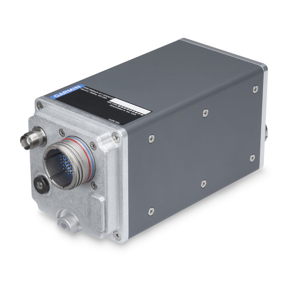
Avionics sensor
Supports GPS guidance
Photo: Garmin
The GPS 3000 is a compact, remote-mount 15-channel GPS receiver capable of five position updates per second. It uses enhanced WAAS/SBAS signals to provide ultra-precise, DO-260B-compliant position data. It provides an ARINC 743A-5 GNSS interface over an industry-standard ARINC 429 data bus for those who wish to integrate GPS 3000 with existing avionics systems. When so configured, the GPS 3000 sensor can provide position source information to the FMS, meeting requirements for required navigation performance (RNP) and supporting GPS-based vertical approach capability for coupled LPV approaches and other next-generation flight applications. Garmin, www.garmin.com
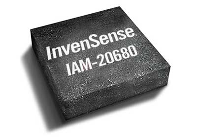
Positioning devices
Auto motion sensors for GNSS-denied environments
Photo: Invensense
A new line of automotive high-accuracy devices is designed to enhance the absolute position of a vehicle in GNSS- and GPS-denied environments: IAM-20680, IAM-20680HP, IAM-20380 and IAM-20381. The IAM-20680 is a 6-axis qualified sensor that features 16-bit accelerometers and 16-bit gyroscopes. The IAM-20680HP is a high-performance version of the IAM-20680 that features high gyroscope and offset thermal stability. The IAM-20380 gyroscope is compatible with a 3-axis automotive accelerometer and an automotive-qualified 6-axis device. The IAM-20381 is a 3-axis accelerometer compatible with a 3-axis automotive gyroscope and an automotive-qualified 6-axis device. The IAM-20680HP and IAM-20680 can be used to improve estimates of position, direction and speed when GNSS is denied, as well as improve quality of the position estimation when the satellite signal is strong. InvenSense, www.invensense.com
UAV
Analysis platform
For precision agriculture
Screenshot: Agremo
Agremo is a cloud-based data-processing solution designed to turn drone-collected images of agricultural sites into actionable and accurate data. It is used to collect aerial footage and create an analysis report that reveals how a crop is progressing. The agricultural sensing and analysis platform is designed for drone operators, farmers, growers and agronomists. Using Agremo, drone operators can help farmers monitor and manage their crops per field throughout the season. A visualized, user-friendly, geo-referenced map of a field can provide statistics such as plant counting, plant health tools and stress detectors that enable precise yield increase and increase of overall profit. Agremo, www.agremo.com
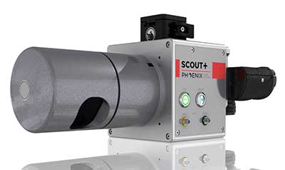
UAV lidar
For light vegetation and medium-range scanning
Photo: Phoenix Lidar Systems
The Phoenix Scout-32 is a powerful, compact, mid-range lidar. The lightweight system collects survey-grade data with an AGL range up to 65 meters, and features multi-target capacity with up to two target echoes per laser shot. It can build high-density point clouds of smaller scan areas, and has options for photogrammetry, hyperspectral, thermal imaging and more. Phoenix Lidar Systems, www.phoenixlidar.com
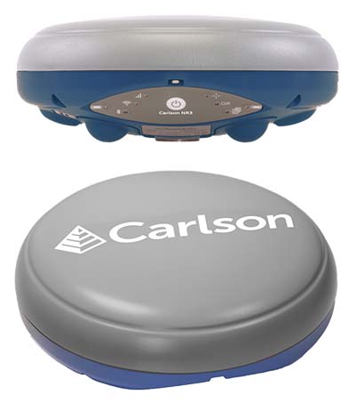
Carlson Software has introduced a new four-constellation, three-frequency surveying receiver. The Carlson NR3 network rover weighs just under two pounds, but delivers highly reliable GNSS real-time kinematic (RTK) for land surveying, geospatial information systems (GIS) and other data-collection uses.
Carlson Software President and Founder Bruce Carlson introduced the Carlson NR3 network rover at the company’s Grow With Us User Conference 2019.
Able to be used as a base or rover, the NR3 uses all four constellations — GPS, GLONASS, BeiDou and Galileo — and provides triple-frequency tracking on GPS, GlONASS and Galileo, the company said.
Incorporating multipath and ionospheric detection, the NR3 maintains accuracy and continued operation despite shocks, vibration or other interference.
According to the company, the NR3 is easy to mount and balance as it utilizes the optional Hybrid+ in Carlson SurvCE/PC that enables simultaneous interaction with GNSS and a robotic total station, the company said.
”The NR3 is Carlson’s answer for a lightweight – just 1.8 lbs. – network rover that can also be used in a base rover setup with Carlson’s Listen-Listen service,” said Butch Herter, Carlson’s director of Hardware Development. The Listen-Listen service allows base/rover operations via cellular modem for better correction transmission ranges compared to traditional terrestrial UHF radios.
“It has hot swappable batteries and four come with the system that give it over a 20-hour runtime,” Herter added. “With the dual internal cell modem antennas, it maintains cell signal where others may not. When paired up with the Carlson CR2+ robot, it is the ideal companion receiver to use with the new SurvCE hybrid surveying system.”
Produced by Septentrio with Carlson specifications, the Carlson NR3 has an integrated 4G LTE cellular modem, plus Wi-Fi and Bluetooth for modern wireless capabilities and is made to perform exceptionally in locations with bad visibility or interference.