Topcon Positioning Group and MAVinci GmbH have released the latest version of the Sirius Pro surveying UAS (Unmanned Aerial System) program, designed to be compatible with existing RTK (real-time kinematic) base stations or NTRIP (network transport of RTCM data over IP).
“By connecting an external base station, Sirius Pro will receive the RTCM correction signals and deliver 2-5 centimeter accuracy without using ground control points,” said Eduardo Falcon, executive vice president and general manager for the Topcon GeoPositioning Solutions Group. “When you have mobile Internet on your site, you can achieve the same accuracy even without a local base station using NTRIP.”
Sirius Pro is designed to deliver orthofotos and three-dimensional elevation models with a high absolute accuracy of 2-5 centimeters without using ground control points. “Combining MAVinci‘s precision timing technology with Topcon sub-centimeter grade L1/L2 GPS/GLONASS RTK receivers, this robust system stands up with a clever solution that helps in the realizing of projects in a better and faster way,” said Johanna Claussen, CEO at MAVinci.
For users who do not have an RTK base station, an internal base station add-on for the Sirius Pro is available. “It upgrades the Sirius Pro to its full functionality: Use of an internal or external base station depending on your needs,” Claussen said. “This add-on is available anytime via Internet without changing your hardware.”
Sirius Basic is an entry-level solution for UAS surveying, and delivers orthofotos and 3-D elevation models. The system is designed to offer high-accuracy when using ground control points. “Sirius Basic offers you full flexibility,” said Falcon. “It can be upgraded to Sirius Pro via an Internet update later on — no hardware change is necessary.”
The system will be available at the Intergeo trade show for geodesy in October and thereon. The Topcon and MAVinci UAS was first introduced at Intergeo 2013 for the European market and was recently made available in the North American market.
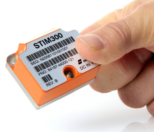
The STIM300 is a small, tactical-grade, low-weight, high-performance non-GPS aided IMU. It contains three highly accurate MEMS gyros, three high-stability accelerometers and three inclinometers. The IMU is factory calibrated and compensated over its temperature operating range.
The STIM series is designed for use below and on the ocean, on land, in the air, and in orbit and space. The STIM300 IMU is well suited for stabilization, guidance and navigation applications in the industrial, aerospace and defense markets. It is a crucial building block for inertial navigation systems in UAVs, AUVs, AGVs, UGVs and ROVs, Sensonor said.
The STIM300 is also used for camera turret stabilization and for use in various handheld devices that require a small IMU to secure operations during GPS outage.
SG Systems’ IG-500 Series of miniature inertial sensors. Photo: SBG Systems
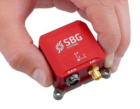
SBG Systems has released the Ellipse Series, a product range of miniature inertial systems replacing the IG-500 Series. For the same budget, customers benefit from higher accuracy, advanced filtering and features of high-end inertial navigation systems, the company said.
The Ellipse Series of miniature inertial systems benefits from a new design, new sensors, new capabilities, and new algorithms. “We have selected state-of-the-art MEMS sensors, especially very low noise gyroscopes that greatly enhance Ellipse performance. We integrated cutting-edge GNSS receiver while keeping a small size,” said Alexis Guinamard, CTO of SBG Systems.
“We are able to upgrade miniature sensors capabilities by injecting some advanced and proven filtering and features inspired from high end inertial navigation systems,” Guinamard said. Besides higher accuracy, SBG Systems added for the same budget an improved FIR and rejection filtering, robust IP68 enclosure, high output rate, RTK corrections, and automatic alignment.
Weighting from 45 grams, Ellipse sensors are flexible. The Ellipse-A model provides 3D orientation and heave. For navigation, users can connect their own GPS receiver with the Ellipse-E, or use an internal receiver by choosing the Ellipse-N model. The larger Ellipse-D integrates a survey-grade L1/L2 GNSS receiver with two antennas for heading and position accuracy.
Ellipse A, N, E models are available for order now. The Ellipse-D model will be available in the first quarter of 2015.
Topcon Positioning Group has released two unmanned aerial systems (UAS) for mapping — the Sirius Pro and Sirius Basic. Both systems are designed to produce the most accurate solutions for the automated mapping of a wide range of sites — regardless of terrain — including construction sites, mines and quarries, and for use in land surveying, power line and pipeline inspection as well as precision agriculture field mapping.
The fixed-wing systems resulted from a partnership with MAVinci GmbH, a UAS development company with which Topcon recently entered into a worldwide distribution agreement.
“The Sirius Pro system is unique to the UAS marketplace. Instead of using traditional ground control points, Topcon combines RTK (real-time kinematic) GNSS solutions with precision timing technology to provide more accurate mapping results when compared to other products,” said Eduardo Falcon, executive vice president and general manager for the Topcon GeoPositioning Solutions Group.
“The system is easy to use and rugged — allowing operators to use a simple hand launch with precise automatic operation from takeoff to landing, and it can be flown safely in nearly all weather conditions,” Falcon said.
The Topcon Sirius Basic is an entry-level system offering many of the advantages of the Sirius Pro with options to upgrade. “The Sirius Basic shares the same hardware components of the Pro model, providing affordability with the same level of sturdiness and ease of operation,” said Falcon. “Additionally, when the need arises for the increased accuracy and productivity of the Pro system, a simple upgrade makes the transition practically effortless.”
Both systems also offer autopilot assisted manual control, automatic flight planning and safety features.
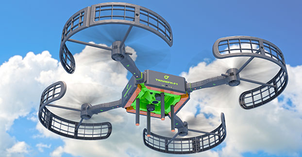
JAVAD GNSS is introducing its new unmanned aerial vehicle with the dramatic flourish of a video showing the UAV in flight, accompanied by the “Also Sprach Zarathustra” theme from 2001: A Space Odyssey.
The TRIUMPH-F1 unmanned aerial vehicle is based on the JAVAD GNSS TRIUMPH-1. TRIUMPH-1 is the company’s field-tested high-precision geodetic GNSS receiver with 864 channels to track all current and future GNSS signals.
When used on the ground, the TRIUMPH-F1 can function as a TRIUMPH-1 base or rover. The four motor arms (for eight motors) are detachable. There are four screw inserts in the bottom to attach the TRIUMPH-F1 to a pole mount for field use.
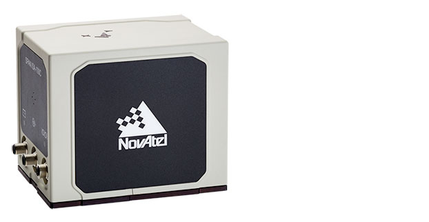
NovAtel Inc. has added the IMU-ISA-100C as an inertial measurement unit (IMU) option to its SPAN GNSS+INS line of positioning products. The IMU-ISA-100C is a high-performance, near navigation-grade IMU designed for platform stabilization, general-purpose navigation, photogrammetry, remote sensing, and ground mobile-mapping applications.
Commercially exportable, the IMU-ISA-100C integrates easily with a NovAtel SPAN capable receiver to provide a tightly coupled 3D navigation solution, NovAtel said. Offering customers continuous position, velocity and attitude (roll, pitch and azimuth) measurements, a SPAN system is stable and available even through periods when satellite signals are blocked or unavailable.
With the IMU-ISA-100C, customers will receive near navigation-grade performance, at an affordable price point. The product also features a new enclosure designed to maximize versatility for a range of applications.
“The compelling aspect of this product is its value — it is a high-end SPAN solution, delivering extremely precise positioning, at an attainable price point,” said Siamak Akhlaghi, NovAtel’s product manager, SPAN. “And without the export constraints, it can be shipped internationally in a timely fashion.”
JAVAD GNSS is introducing its new unmanned aerial vehicle with the dramatic flourish of a video showing the UAV in flight, accompanied by the “Also Sprach Zarathustra” theme from 2001: A Space Odyssey.
The TRIUMPH-F1 unmanned aerial vehicle is based on the JAVAD GNSS TRIUMPH-1. TRIUMPH-1 is the company’s field-tested high-precision geodetic GNSS receiver with 864 channels to track all current and future GNSS signals.
When used on the ground, the TRIUMPH-F1 can function as a TRIUMPH-1 base or rover. The four motor arms (for eight motors) are detachable. There are four screw inserts in the bottom to attach the TRIUMPH-F1 to a pole mount for field use.
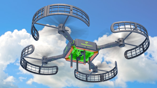
The TRIUMPH-F1 features user-friendly mission programming. The four lithium polymer batteries that power the eight propeller motors, arranged in a stacked quad formation, each have a test button and LEDs to indicate the current charge level, as well as accessible ports for easy charging.
The TRIUMPH-F1 also has two micro-SD slots for image storage, a SIM card slot, a USB connector for uploading flight plans and downloading collected images, and indicators for satellite tracking and communications. Other indicators are dedicated to flight status and gyro. It comes equipped with four angled documentation cameras and a downward high-precision camera for photogrammetry.
JAVAD GNSS will exhibit the new device at InterGeo, to be held October 7-9 in Berlin.
To learn more, watch the video or visit JAVAD GNSS.
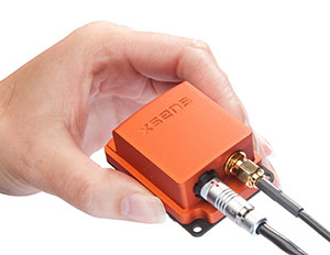
The MTi-G-700 by Xsens is a GPS-aided, IMU-enhanced GPS/INS that offers high-quality orientation and position. It makes use of sensory measurements from magnetometer, barometer, and a high-sensitivity GPS-L1 receiver to provide navigation estimates of position, velocity, and orientation at high data rates under high-dynamic conditions.
The Xsens estimation engine (XEE) sensor-fusion framework enables the motion tracker to take advantage of different aiding sensor measurements and optimally fuse them to get robust tracking estimates. The MTi-G-700 has a u-blox 6 internal 50-channel L1C/A code receiver with 2-meter horizontal accuracy and 5-meter vertical accuracy; SBAS; a 4-Hz update rate; 27-second cold start-up time; and -161 dBM tracking sensitivity.
The MTi is being used by customers for many maritime and oceanographic applications that require 3D orientation, 3D position, 3D velocity, and 3D dynamic data, such as a monitoring system in a barge master vessel where the MTi monitors the movement of a wave-compensated crane.
Like it or not, as a person who works with geospatial data, UAS (unmanned aerial systems such as drones and UAVs) are in your future. The upside of said technology for “quick and dirty” mapping is undeniable.
GNSS plays a key role with UAS, just like it plays a key role in classical photogrammetry. In fact, UAS may even push GNSS technology into areas where it hasn’t gone. For example, L1 RTK. I wrote about L1 RTK technology several years ago, and while several products attempted to exploit it, L1 RTK never was adopted in any significant numbers, primarily due to the short baseline, clear sky, and longer initialization requirements. However, UAS may change that because, by their nature, they work with short baselines, clear sky environments and require some setup time, at least enough for L1 RTK initialization.
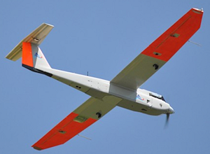
However, before we get ahead of ourselves, the regulatory machine (the Federal Aviation Administration) must publish regulations that provide guidelines on the use of UAS for commercial operations. In June, amidst its recent enforcement actions, the FAA issued its first commercial authorization for mapping UAS over land in the U.S. The FAA issued a Certificate of Waiver or Authorization (CoA) to BP to conduct aerial surveys in Prudhoe Bay, Alaska. According to the FAA, the first flights took place on June 8 and used a AeroEnvironment 13.5 lb. Puma AE fixed-wing UAS with a nine-foot wingspan.
According to a Wall Street Journal article, AeroEnvironment spokesman Steve Gitlin said it took about a year and considerable financial investment to win FAA approval for the BP project. Curt Smith, a director in BP’s technology office, said that manned aircraft are sometimes less expensive per flight than the AeroVironment devices, but that the drones will gather far more data, enabling BP to operate “more effectively, more safely, and at a lower cost.”
The FAA announced that last summer that it issued restricted category type certificates to the Puma and Insitu’s Scan Eagle, another small UAS. The certificates were limited to aerial surveillance only over Arctic waters. The FAA recently modified the data sheet of the Puma’s restricted category type certificate to allow operations over land after AeroVironment showed that the Puma could perform such flights safely.
Texas A&M University Becomes Fourth Operational UAS Test Site
In further UAS news, the FAA announced on June 20 that Texas A&M University – Corpus Christi became the fourth of six UAS test sites to become operational. The FAA issued a CoA for the university to use an 85 lb AAAI RS-16 UAS with a ~13-foot wingspan. The other five UAS test sites are Griffiss (NY) International Airport, North Dakota Department of Commerce, State of Nevada, University of Alaska, and Virginia Polytechnic Institute and State University.
American Aerospace RS-16 UAS. 12’11” Wingspan. 85 lbs.
The FAA UAS Legal Stuff
Despite its setback when an NTSB administrative law judge ruled against the FAA in March 2013, the FAA sternly maintains its position that commercial operations of UAS in the U.S. are strictly prohibited without a CoA. In fact, just this week (June 23), the FAA issued a press release about a Federal Register Notice the FAA published of its interpretation of UAS rules for model aircraft in the FAA Modernization and Reform Act of 2012. In the Act, the Sec. 336 Special Rule for Model Aircraft reads:
SEC. 336. SPECIAL RULE FOR MODEL AIRCRAFT
(a) IN GENERAL.—Notwithstanding any other provision of law relating to the incorporation of unmanned aircraft systems into Federal Aviation Administration plans and policies, including this subtitle, the Administrator of the Federal Aviation Administration may not promulgate any rule or regulation regarding a model aircraft, or an aircraft being developed as a model aircraft, if—
(1) the aircraft is flown strictly for hobby or recreational use;
(2) the aircraft is operated in accordance with a community-based set of safety guidelines and within the programming of a nationwide community-based organization;
(3) the aircraft is limited to not more than 55 pounds unless otherwise certified through a design, construction, inspection, flight test, and operational safety program administered by a community-based organization;
(4) the aircraft is operated in a manner that does not interfere with and gives way to any manned aircraft; and
(5) when flown within 5 miles of an airport, the operator of the aircraft provides the airport operator and the airport air traffic control tower (when an air traffic facility is located at the airport) with prior notice of the operation (model aircraft operators flying from a permanent location within 5 miles of an airport should establish a mutually-agreed upon operating procedure with the airport operator and the airport air traffic control tower (when an air traffic facility is located at the airport)).
(b) STATUTORY CONSTRUCTION.—Nothing in this section shall be construed to limit the authority of the Administrator to pursue enforcement action against persons operating model aircraft who endanger the safety of the national airspace system.
(c) MODEL AIRCRAFT DEFINED.—In this section, the term ‘‘model aircraft’’ means an unmanned aircraft that is—
(1) capable of sustained flight in the atmosphere;
(2) flown within visual line of sight of the person operating
(3) the aircraft; and
(4) flown for hobby or recreational purposes.
You can read more (lots more) about the FAA’s interpretation of the Act here. You can submit a comment on the FAA’s interpretation of the Act here. The comment period ends July 25.
More FAA UAS Legal Stuff
On June 25, the FAA issued a press release announcing that seven aerial photo and video production companies requested regulatory exemptions from the FAA to operate UAS before the FAA UAS rule-making is finalized. According to the FAA, “the Motion Picture Association of America facilitated the exemption requests on behalf of their membership. The firms that filed the petitions are all independent aerial cinematography professionals who collectively developed the exemption requests as a requirement to satisfy the safety and public interest concerns of the FAA, MPAA, and the public at large.”
From the FAA press release, “The FAA published a brief summary of the petition from Astraeus Aerial in the Federal Register. The agency opted to ask for comments only on the Astraeus petition because that company’s request came in first, and the petitions from the other six companies ask for identical exemptions.”
Interestingly enough, the FAA is soliciting public comment before it makes a ruling on the MPAA request, clearly highlighting the tremendous pressure the FAA is under to integrate commercial use of UAS in the U.S.
More Commercial Use of UAS Despite what the FAA Says
The NTSB ruling against the FAA fueled the commercial UAS fire and certainly gave commercial UAS operators, operating illegally according to the FAA, more confidence that the FAA may not pursue them. That might be the case in an incident publicized last week in Seattle, Washington, where a woman called police after she saw a UAS buzzing around outside of her apartment building, believing it was spying on her 26th-floor apartment. The Portland, Oregon-based UAS operator, Skyris Imaging, was interviewed by Portland’s KATU news.
“It was not our intent to view anything other than the views from a 20-story office building that will be built across the street,” said Skyris’s Joe Vaughn. Vaughn told KATU that a Seattle-based developer hired Vaughn’s company to use one of his drones equipped with cameras to take photos of the view for a new 20-story building.
Vaughn told KATU that his company has a fleet of six drones he says he responsibly flies. He told KATU that his company has strict guidelines to never fly for a third party, over crowds, above 400 feet, or beyond visual range. Click below to view the KATU interview.
Live Webinar at the Esri International User Conference
In a GPS World first, we’ll be producing a live webinar from the Esri International User Conference on Thursday, July 17, @ 10 a.m. Pacific Time in the exhibit hall at the San Diego Convention Center. Of course, the webinar will be focused on one of the hottest topics: high-precision mobile GIS. It will cover high-precision GNSS on mobile devices, from iPads to Android tablets to smartphones.
Tune in or join us live from the exhibit hall floor! Register here.
Half the year is over. It’s gone. Now it’s time to figure out where the location industry is going for the remainder of the year. One analyst (actually, several) believe that the industry, fueled by indoor location and place-based advertising, is around $14 billion right now — with no place to go but up — given some bump in consumer awareness. In other news in a busy month, Google bought Skybox Imaging for $500 million in cash.
As the mid-point of 2014 arrives, with a few big location industry deals already consummated, there is a chance for industry executives to study what is going to be a strong niche market in the months ahead.
One analyst believes a big location niche is indoor analytics and proximity marketing, which is defined as nearby a store or within a business. “The latter would include ads and coupons. We’ve estimated that roughly $3.5 billion of potentially $14 billion, or so, in 2014 U.S. mobile ad revenue, will be location-based [broadly defined],” said Greg Sterling, founder of Sterling Market Research. “Of that, about $1.4 billion will be ‘geofenced’ or nearby.”
Sterling believes that the in-store component is still in an embryonic stage. “There are billions of dollars of coupons distributed every year, but most of that is still print. Some of that is in-store distribution and redemption,” he said. “A portion of that over time will migrate to mobile in or near stores.”
Sterling said there are billions of dollars available from proximity marketing, but it will take time. He cites “Mapping the Indoor Marketing Opportunity,” a report he authored for Opus Research, that says the market for indoor location and place-based marketing/advertising will surpass $10 billion by 2018. (See a preview of the report here.)
In a published report, Sterling admitted that he was nervous about the $10 billion number, but it may turn out that the figure could be conservative because of the software licensing from indoor markets.
Sterling says that while indoor positioning has been important to the older location business, it is still in its early stages. The big deal is mobile, which has brought new attention and interest to location, he said. “Indoor location will feed mobile and online marketing with data and analytics as well as targeting opportunities,” he said.
Many executives and analysts in the location industry have marginalized privacy issues; some even say it is dead with opt-in approval by consumers. However, privacy issues will continue to hamper the location industry, Sterling said.
“Privacy is far from dead. Indeed, it’s on the rise, and a major issue that everyone in the location and mobile segments needs to tackle head on,” Sterling said. “Denial, delay and obfuscation will result in regulatory intervention and/or consumer fear/rejection.”
In a blog, Sterling said that the San Francisco-based Philz Coffee chain no longer will be tracking customers after a local ABC affiliate revealed they were using Euclid retail analytics. Sterling said the ABC report acted as if it had uncovered a big government or corporate conspiracy.
Sterling will be giving the keynote address at the Place Conference in New York on July 22 at the W Hotel. Topics include proximity marketing, indoor positioning markets, privacy and other location topics.
Google Continues Location Industry Dominance with Acquisition
Google enhanced its online mapping service by acquiring Mountain View, California-based Skybox Imaging for $500 million in cash. Sources say both Google and Facebook are purchasing satellite and drone companies in an attempt to expand into other market areas.
One of the ways Google will be leveraging Skybox is in disaster relief and to improve Internet access in remote areas, something the company has been strongly pursuing.
On its website, the five-year-old Skybox said that it plans also to share in the development of the burgeoning autonomous vehicle market and continue to design its own satellites.
A Skybox satellite image of Tampa, Florida.
AT&T Expands Location Information Services
AT&T’s new Location Information Services, which includes a security function and LBS, is expanding into more than 150 countries this summer in a pilot project. The Location Information Services are enabled through an API that can notify companies when their customers, who opt-in for the service, arrive in a new country.
Some application examples, provided by AT&T, include credit card companies confirming customers have traveled to a new country as soon as a device is turned on; allowing the credit card company to either decline or approve purchases overseas; companies using the service to track the movement of equipment to prevent stolen property; and the ability for hospitality entities to offer restaurant and other suggestions to consumers based on their location.
In other LBS news:
The new Amazon Fire Phone has GPS and location functions plus a new feature, Dynamic Perspective, which can be used for such built-in apps as maps and games. The phone is available on July 25, but Amazon is taking pre-orders. In the meantime, competitor Apple has a new iOS 8 feature that allows shoppers to enter their payment details on an m-commerce site by scanning their credit card with the camera on their mobile device, according to published reports. The operating system will use sensors to provide apps with indoor positioning data.
HERE acquired the mobile predictive analytics firm, Seattle-based Medio, earlier this month. The company plans to integrate Medio’s predictive analytics, in conjunction with its map platform, to customize LBS “prediction experiences” for consumers, according to published reports. These experiences (full disclosure, I hate it when companies use the word, “experience”) may include delivering restaurant or other information at a relevant time, such as around lunch. While no financial details were released, the deal is expected to close at the end of July.
Hundreds of businesses in Brixton, near London, will be integrating Apple’s iBeacon as part of the first networks for mobile payments, according to published reports. Businesses in Brixton are switching from currency payments to mobile payments by text. Previously, iBeacons have been used for proximity offers, advertisements and product information when a user is in a retail area. The mobile payment application allows users to quickly check out, reports say.
The U.S. Army Tank Automotive Research, Development and Engineering Center (TARDEC) and Lockheed Martin successfully demonstrated additional capabilities of the Autonomous Mobility Appliqué System (AMAS) May 29 at the Department of Energy’s Savannah River Site in South Carolina.
They conducted a driverless line-haul convoy with seven military trucks at speeds up to 40 mph.
The AMAS CAD II demonstration built upon capabilities demonstrated at Fort Hood, Texas, in January, when three unmanned military trucks negotiated oncoming traffic, followed rules of the road, recognized pedestrians, and avoided various obstacles at speeds up to 25 mph in an urban environment.
AMAS is a Joint Capability Technology Demonstrator, or JCTD. That means it’s a joint program between the U.S. Army and the U.S. Marine Corps. The AMAS common appliqué kit consists of the bi-wire active safety kit and the autonomy kit. It uses GPS, lidar systems, Automotive radar, and commercially available automotive sensors to make the system affordable. The AMAS JCTD goal is to standardize these kits across both the Army and Marine Corps and give the warfighter the ability to transform ordinary vehicles into optionally manned vehicles.
Colonel Bruce B. McPeak, Director of Materiel Systems, Combined Arms Support Command, climbs into a Heavy Equipment Transporter (HET) for an autonomous ride-along.
TARDEC is working closely with the U.S. Army Training and Doctrine Command (TRADOC), military users, and the acquisition community to advance the development of autonomous appliqué systems for tactical vehicles and make these capabilities available by 2020.
Autonomy-enabled vehicles will reduce accidents while augmenting the warfighter, and increase capabilities by creating greater stand-off distance from danger, which would make supply distribution safer and more efficient, and provide the flexibility to adapt to tomorrow’s ever-changing and evolving threats.
“The driverless vehicle is coming in both commercial and military applications,” said Bernard Theisen, TARDEC’s AMAS Technical Manager. “The Army is at the forefront of this technology.”
Military and industry VIPs drove alongside the convoy in a bus to watch the unmanned convoy demonstration.
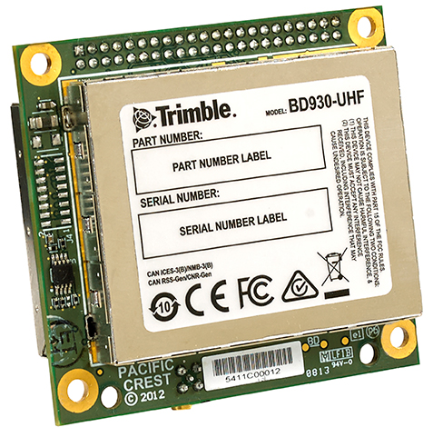
The Trimble BD930-UHF high-performance integrated UHF receiver.
Trimble has introduced the Trimble BD930-UHF receiver and communication module. As part of Trimble’s GNSS OEM portfolio, the new compact module features centimeter-level, Real-Time Kinematic (RTK) positioning capabilities coupled with an integrated UHF receiver for precise mobile positioning. The BD930-UHF module’s connectivity and configuration capabilities allow system integrators and OEMs to easily add GNSS, centimeter-level positioning to specialized or custom hardware solutions.
“The OEM and system integrator communities demand high performance, reliability and support for their positioning solutions,” said Dale Hermann, general manager of the Integrated Technologies division at Trimble. “The Trimble BD930-UHF delivers the latest GNSS and communication technology in an easy-to-integrate form factor for demanding conditions and applications such as field computing, port automation and lightweight robotic or unmanned vehicles. With the BD930-UHF module, customers are purchasing a solution not just a GNSS receiver.”
Taking advantage of Trimble’s expertise in both GNSS and UHF communications, the Trimble BD930-UHF module has been designed for applications requiring centimeter accuracy in a compact package. By integrating wireless communications on the same module, the task of receiving RTK corrections is significantly simplified.
The triple-frequency GPS/GLONASS/BeiDou/Galileo BD930-UHF provides customers with a multi-constellation solution that can reduce their integration effort and time to market. Ethernet connectivity and onboard web server allows high-speed data transfer and configuration via standard browsers. USB and RS232 ports are also supported. By tightly integrating communications with the GNSS receiver, integrators can reduce costs, power, weight and size.
The Trimble BD930-UHF is expected to be available in July 2014 through Trimble’s Precision GNSS + Inertial sales channel worldwide.