The U.S. National Transportation Safety Board has ruled that drones are aircraft for the purpose of the Federal Aviation Administration’s prohibition of their careless or reckless use.
The NTSB affirmed the agency’s position that unmanned aircraft systems (UAS) meet the legal definition of “aircraft,” and that the agency may take enforcement action against anyone who operates a UAS or model aircraft in a careless or reckless manner.
The FAA appealed a decision by an NTSB Administrative Law Judge in Huerta v. Pirker, after the judge dismissed the FAA’s order requiring Raphael Pirker to pay a civil penalty of $10,000 for operating an unmanned aircraft in a careless or reckless manner at the University of Virginia in October 2011.
The FAA said in a statement, “The FAA believes Mr. Pirker operated a UAS in a careless or reckless manner, and that the proposed civil penalty should stand. The agency looks forward to a factual determination by the Administrative Law Judge on the ‘careless or reckless’ nature of the operation in question.”
Commercial drones are currently banned in the U.S., except for certain exemptions like one announced in September for some TV and movie production companies, as reported by PC World. Amazon.com and Google have said they plan to use drones to deliver goods. The FAA is required by U.S. Congress to frame a “safe integration” plan for the commercial use of UAS by Sept. 30, 2015.
The NTSB was ruling in an appeal against an FAA order that imposed a fine of $10,000 on aerial photographer Raphael Pirker in October 2011 for flying recklessly a powered glider aircraft near University of Virginia at Charlottesville, Virginia. Pinker was said to have been hired to supply aerial photographs and video of the university campus and medical center. He had argued that his aircraft, which was described as an UAS, was in fact a model aircraft.
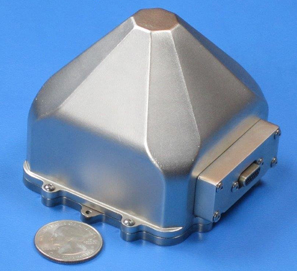
Sensors in Motion (SIM) has introduced a MEMS (micro-electro-mechanical) navigation-grade inertial system (INS) that it says could transform the $8 billion/year inertial market with new products by offering price and performance specifications better than those currently available.
The first INS devices have been delivered to the Army CERDEC Night Vision Electronic Sensors Directorate (NVESD).
SIM, a spinout from NASA’s Jet Propulsion Laboratory and California Institute of Technology, is developing a family of high-accuracy MEMS gyroscopes, accelerometers and inertial measurement unit ( IMU) solutions. It says it has perfected unique MEMS structures using volume silicon wafer processing techniques to produce gyroscopes having ARW (angle random walk) less than 0.0035 degree/root-hour and bias instability less than 0.01 degree/hour with extraordinary vibration and temperature immunity, a performance comparable to ring laser (RLG) and fiber optic (FOG) gyros that are 20 times larger and 100 times more expensive.
These features are mandatory for numerous applications where location is not available from GPS or vehicle position accuracy is required including autonomous vehicles, drones, mining asset tracking, dead reckoning, agricultural seed placement, oil and gas directional drilling, self-driving autos, firefighter navigation, optical image stabilization, industrial equipment azimuth, aerospace and defense products and most GPS-denied environments, in addition to new applications.
Current devices would have a vehicle position off as much as 1 foot per second at 45 miles per hour.
“We see this technology opening an additional $2B sensor market needing size, weight, power, cost and performance that does not exist today. “ said David Smukowski, CEO of SIM.
With adequate resources the company says further performance gains are possible, even while shrinking the devices smaller for better economics.
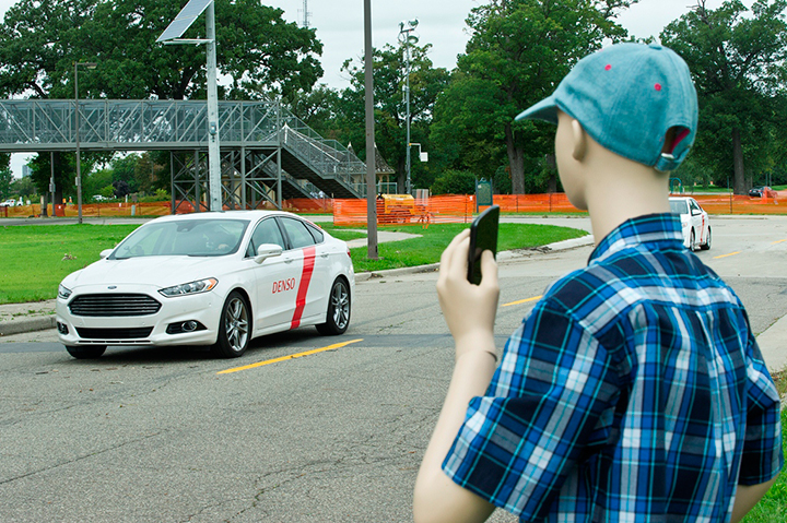
Denso Corp. began testing advanced driving support technology on a public road in Aichi Prefecture, Japan, this past June. Denso is testing automated driving scenarios in a single lane and testing automatic lane changes, as well as other driving maneuvers. Denso’s goal is to develop technologies that reduce driver workload and assist in safe driving.
Previously, Denso tested this technology on its test course in Japan. Denso’s goal with public road testing is to identify, analyze, and solve real-life problems that don’t occur on the test course.
Denso is conducting the field tests as part of activities led by the Vehicle Safety Technology Project Team to reduce traffic accidents. The project team is organized by the Aichi prefectural government and involves companies and organizations operating in the prefecture.
Denso has been developing its advanced driving assistance technology to achieve safer and more reliable driving while the driver remains in control of the vehicle. Development and commercialization of this technology will help prevent traffic accidents and contribute to increasing safety of our automotive society.
Denso Corporation, headquartered in Kariya, Aichi prefecture, Japan, is a global automotive supplier of advanced technology, systems and components in the areas of thermal, powertrain control, electronics and information and safety. Its customers include all the world’s major carmakers.
Testing involves automated driving on a single lane.Automatic lane changes are also being tested.
IAV Automotive Engineering test vehicle. Photo: Denso
The autonomous, or driverless, vehicle market seems to be a big side topic at connected car conferences. Location technology will continue to play a role in the development of autonomous vehicle markets. However, many view a fully autonomous vehicle to be more than 10 years away — these are usually folks from the auto industry or academia. Others, those who lurk around Silicon Valley, believe that driverless cars will be on the road in half that time…and once again, if Detroit doesn’t move on it, they will.
Just as GPS was once thought of as science fiction — something that naysayers said would not be fully operational for decades — autonomous vehicles are now thought of as an extension of the connected vehicle market. However, technology and legal issues will make the implementation of an autonomous, or driverless car, a tenuous road in the next few years.
One executive from Verizon Telematics, which is a major player in connected car technology, said it is going to take time, perhaps between the years 2025-2030, to grow the autonomous vehicle market.
“You just can’t flip a switch and have autonomous vehicles [on the road]. You have to take baby steps to develop a network, build an infrastructure and condition the marketplace,” said Kevin Link, Verizon Telematics senior vice president. “The collaboration is going to have to be more than one player, including the government. It was a while before desktop computers evolved into laptops.”
While the technology hurdles will be significant for autonomous vehicles, there are features today that will help shape the market, Link said. “Mercedes cars remind people to steer and turn around corners, when to stop at a safe distance and to change lanes,” he said. “These are not taking you from point A to point B autonomously, but real-time connected car features will feed into the autonomous car.”
The evolution of autonomous vehicles will not be derailed at this point, given the intensive research and investment focus from both the private and public sector, said Tim Johnson, NextEnergy director of transportation initiatives. “However, cars that ‘drive themselves’ will not be in mass production in the next five years. Ten years, maybe. Five, no,” he said. “This is not a technology-limited premise. The technologies are rapidly approaching realistic use in limited applications, but the regulatory, liability and infrastructure aspects are far from being fully implemented in the next five years.”
Technology Hurdles Await Early Autonomous Vehicles — More Regulation than Technology?
Some of the technology hurdles center around the speed, capacity and logic of the vehicle and infrastructure systems to manage the significant amount of information required for self-driving vehicles, Johnson said. “If it was possible to wave a magic wand and have all vehicles made simultaneously capable of these communications and logic decisions, it would be much more viable to create a mass, public environment for self-driving cars,” he said. “In reality, there will be an extensive transition period, possibly 15 to 20 years, where capable vehicles will need to deal with incapable vehicles. Once again, this is not so much a technology issue as it is policy, regulation and liability.”
Autonomous Products Already Out There…
Autonomous vehicles will only continue their current momentum as the technology for assisted driving is already well underway with features like self-parking, lane departure warning, predictive collision warning, back-up collision intervention and blind spot prevention, said Scott Frank, Airbiquity vice president of marketing.
An example is the Infiniti Q50, which uses Airbiquity technology for Infiniti InTouch Apps. “What we’re going to see from here is a shift from driver assistance to zero driver involvement — the ultimate expression of autonomous vehicle — where the car does all the driving and there isn’t even a steering wheel or brake pedal,” Frank said. “We won’t see fully autonomous vehicles becoming commonplace in five years’ time due to the massive amount of technology, infrastructure development and integration that needs to happen to ensure the requisite amount of safety.”
NextEnergy’s Johnson said that cars that drive themselves are already in use in restricted access sites, such as military bases, restricted commercial and university locations, national lab campuses and more. “These are the first real-world applications of both the vehicle and infrastructure technologies to test the practical limits of semi-autonomous driver-still-behind-the-wheel cars,” he said. “Much like the FAA use of limited test sites for the development of regulatory aspects of drone flight, these sites are providing the information and insight to move the potential of cars that drive themselves closer to everyday use.”
A Denso autonomous test vehicle drives the track while a plastic friend looks on. Photo: Denso
Will Public Transit Be the First Proving Ground?
Most companies have different opinions when asked whether the public transit area will be the first major market, and serve as the catalyst, for autonomous vehicle growth. “Although we don’t know for sure, it could be that automated public transit programs, will operate in controlled environments with known routes [meaning low speed operation with pedestrians/bicycles operating on the same thoroughfare, but the automated transit system does not have rails or guide ways — the route planning is easily changeable with no impact to the transportation infrastructure],” said Roger Berg, Denso North American Research and Development office vice president.
Denso believes the autonomous vehicle market will encourage additional functionality within the premium car model lines, but gradually these advanced driver assist systems will become more and more common and eventually spread through even the economy car segment, Berg said. “First systems deploy warnings or simple lateral and longitudinal vehicle control. But then functionality for what most people refer to as ‘driverless cars’ or ‘automated driving’ would only be usable under fairly benign driving and traffic conditions, such as some level of automated highway driving,” he said.
Public transit as an “early adopter” business model is viewed to be less probable in the near term as many of the technical challenges facing autonomous operation require significant research and development and capital investment, said Chris Hennessy, IAV Automotive vice president, engineering. “Most of this capital is centered on markets where the return on the investment can be substantial. At the moment, the most likely scenario for a reasonable ROI is in the premium-brand automotive market, where consumers are willing to pay a premium for new technology,” he said. “This market and the technology growth that will occur from this early-adopter market will provide a foundation for cost-effective proliferation of this technology to other markets, where either the operational boundary conditions are narrower or the available capital is lower, which is typically where public transit would fall. Exceptions to this condition could be analogous to the light-rail market, where the interaction to the general public can be controlled and managed with isolated tracks or lanes of travel, but this would require significant planning and capital investment in infrastructure.”
Airbiquity believes that public transit will not be a first adopter. “No, the first adopters will be private parties in urban areas providing a value proposition to people struggling with congested cities, long commutes, and high parking costs. You’re going to see small and innovative companies offering car services with autonomous vehicles operating on city grids at lower speeds,” Frank said. “They will source the autonomous vehicles from non-traditional automotive makers that move faster than traditional automotive makers. Local government will also be involved, since they own the majority of the infrastructure and need to ensure safety standards are established and met.”
In other location news:
Kore Telematics, fueled by a large investment in it by ABRY Partners, bought RacoWireless in an all-cash deal, according to published reports. The transaction will give the companies a combined 3 million M2M subscribers.
The Defense Advanced Research Projects Agency (DARPA) is asking for input on how to launch and recover multiple small unmanned air systems (UAS) from existing large aircraft, such as the C-130. It has issued a Request for Information (RFI) seeking technical, security and business insights on “aircraft carriers in the sky.”
In DARPA’s “blended approach,” a large aircraft would host a small UAS and facilitate its operations. The agency says it would be more cost-effective for intelligence, surveillance, reconnaissance (ISR) and other missions.
Safety is another key aspect of the project. While small UAS can reduce putting an aircraft or pilot at risk, DARPA says it may lack the speed, range and endurance of larger aircraft.
“We want to find ways to make smaller aircraft more effective, and one promising idea is enabling existing large aircraft, with minimal modification, to become ‘aircraft carriers in the sky,’” said Dan Patt, DARPA program manager. “We envision innovative launch and recovery concepts for new UAS designs that would couple with recent advances in small payload design and collaborative technologies.”
The RFI is calling for short responses — no more than eight pages — that must address the following three areas:
System-level technologies and concepts that would enable low-cost reusable small UAS platforms and airborne launch and recovery systems that would require minimal modification of existing large aircraft types. This area includes modeling and simulation as well as feasibility analysis, including substantiating preliminary data if available.
Potentially high-payoff operational concepts and mission applications for distributed airborne capabilities and architectures, as well as relative capability and affordability compared to conventional approaches (e.g., monolithic aircraft and payloads or missile-based approaches). DARPA hopes to leverage significant investments in the area of precision relative navigation, which seeks to enable extremely coordinated flight activities among aircraft, as well as recent and ongoing development of small payloads (100 pounds or less).
Proposed plans for achieving full-system flight demonstrations within four years, to assist in planning for a potential future DARPA program. DARPA is interested not only in what system functionality such plans could reasonably achieve within that timeframe, but also how to best demonstrate this functionality to potential users and transition partners. These notional plans should include rough order-of-magnitude (ROM) cost and schedule information, as well as interim risk reduction and demonstration events to evaluate program progress and validate system feasibility and interim capabilities.
According to a news release by DARPA, technology development beyond the three areas will be considered if it supports the RFI’s goals.
Proposals are due by 4 p.m. ET on Nov. 26, 2014, to [email protected].
At InterGeo 2014, James Van Rens, chief executive officer of Riegl, explains the launch of the RiCopter UAV with LiDAR integration, and its designer gives a live demonstration of the UAV in flight. The show was held October 7-9 in Berlin.
The unmanned aerial vehicle is a survey-grade unmanned scanning platform for a variety of demanding applications, such as corridor, power line, or railway mapping.
The high-performance UAV can be equipped with the Riegl VUX-1 survey-grade LiDAR sensor to offer a fully integrated turnkey solution. The RiCopter platform design includes a fully integrated Riegl VUX LiDAR sensor, IMU/ GNSS unit with antenna, control unit, and up to four optional cameras providing measuring characteristics of a 330-degree field of view, 500,000 measurements per second, and 10-millimeter accuracy.
The class 1 unmanned aircraft system can be flown at a maximum operating altitude of 550 meters with a maximum take-off mass of up to 25 kg and a maximum payload of 16 kg, providing a long flight endurance of 30 minutes.
RiCopter flight characteristics are smooth and stable in hovering positions, as well as on demanding flight maneuvers under challenging conditions.
Robert Dumont of Antcom Corporation discusses the company’s unmanned systems antennas and geodetic survey antennas while at the InterGeo Conference and Trade Fair held October 7-9 in Berlin.
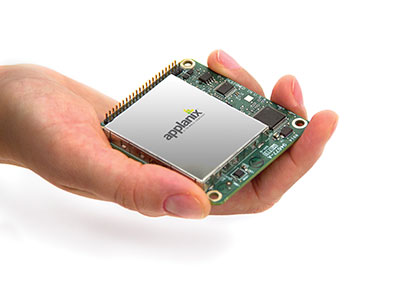
Applanix, a mobile mapping and positioning company, has introduced a new product that enables major improvements in unmanned airborne mapping: the Applanix APX-15 UAV GNSS-Inertial System. The announcement was made at InterGeo, being held this week in Berlin.
The APX-15 UAV is designed to maximize the efficiency of mapping from small unmanned aerial vehicles (UAVs) by reducing — or even eliminating — Ground Control Points (GCPs). Sidelap is also significantly reduced, increasing the area flown per mission. The Applanix APX-15 UAV provides performance in a small package and, with the included POSPac UAV post-mission software, produces a highly accurate position and orientation solution for direct georeferencing of cameras, LIDARs and other UAS sensors, the company said.
“Applanix has recognized the need to provide the growing UAS mapping market with the same highly efficient solutions that it pioneered for airborne mapping over 15 years ago,” said Joe Hutton, Director of Inertial Technology and Airborne Products at Applanix Corporation. “We are offering a cost-effective solution that meets the size, weight, power and cost requirements of small UAS, and maintains the Applanix pedigree for quality and performance.”
The APX-15 UAV, measuring just 6 cm x 6.7 cm and weighing only 60 grams, features a high-performance, survey-grade, multi-frequency GNSS receiver and low-noise MEMS inertial sensors all on a single board. The Applanix IN-Fusion GNSS-Inertial integration technology runs directly on the GNSS receiver, resulting in an ultra-compact design, while superior performance is achieved from the inertial sensors using the Applanix SmartCal software compensation technology.
With 220 channels, the APX-15 UAV tracks all available GNSS satellite signals including GPS L1/L2/L2C/L5 and GLONASS L1/L2, QZSS, BeiDou and Galileo, and provides a highly accurate post-mission and real-time RTK GNSS-inertial position and orientation solution to support guidance and control, precision landing and sensor geo-referencing.
APX-15 UAV is expected to be available worldwide in the first quarter of 2015 through the Applanix sales channel.
Data Mapper, an enterprise aerial data software by PrecisionHawk, will expand its cloud-based platform to process data collected by a wider network of unmanned aerial vehicle (UAV) providers. The application provides the ability to upload, store, process and share aerial imagery and is equipped for detailed, automated analysis.
Previously the company was known under the name PrecisionMapper, and the software could only be used when collecting aerial data with the PrecisionHawk UAV platform Lancaster HawkEye Mark III.
“As we began to collect data with the PrecisionHawk UAV across data intensive industries, we discovered a clear gap in the market for an end-to-end, enterprise level solution,”said Christopher Dean, CEO of Data Mapper. “The creation of Data Mapper was a way for us to ensure that what matters most to our customers, the ability to transform aerial data into actionable information, was available quickly and cost effectively.”
The platform is accessible on numerous devices and allows a user to see data in real time, long before a processed orthomosaic is available. Post processing is automated, and processed data can be shared across devices or analyzed using sophisticated algorithms. Data Mapper geospatial experts have been working closely with university partners across the nation to determine the most pressing algorithms for the agriculture industry such as plant height, weed detection, plant counting and canopy cover.
Because of its early integration with the PrecisionHawk platform, Data Mapper has a strong client base that includes Fortune 500 companies, global agriculture companies, education and research institutions and individual agricultural producers, PrecisionHawk said.
As the UAV industry quickly expands, data intensive markets such as agriculture can be equipped with a streamlined, information delivery structure that fits into an everyday workflow. Engineers have bootstrapped the technology to ensure seamless integration with workflows that rely heavily on accurate information to support business practices, PrecisionHawk said.
“UAVs are an extremely effective and efficient means for collecting data, but the value of this technology goes far beyond an aircraft,” said Andrew Slater, VP of software development for Data Mapper. “Data Mapper is a tool designed to close the gap between a service that UAVs provide and the value of that service, which isinformation delivery to the right person at the right time.”
The company has worked with data sets across a variety of industries including agriculture, oil and gas, emergency response, forestry and insurance, and will continue to extend its analysis capabilities to different markets. Data Mapper will significantly grow its employee base, hiring geospatial analysts, software engineers and embedded software engineers to work towards a generalized ingestion method for all UAV data in 2015.
Oxford Technical Solutions (OxTS) has announced the latest addition to its OEM line of inertial navigation systems, the xOEM500. The OxTS is a high-performance GNSS/INS system embedded on a single compact board set. It offers dual GNSS receivers and a high-grade MEMS IMU (inertial measurement unit) to system integrators in an easy-to-integrate 120-g package.
With attractive prices for volume sales, the xOEM500 is one of the world’s smallest tactical-grade INSs available.
Thomas Seiler, u-blox CEO, holds a drone with GPS embedded.
Several companies at CTIA Super Mobility Week, held in Las Vegas September 9–11, are attempting to find niche opportunities in the crowded machine-to-machine market — and Switzerland-based u-blox is no exception. The company is focusing on the mobile, industrial and consumer-location markets, said Thomas Seiler, u-blox CEO.
While Seiler says there is no one dominant market for u-blox, the fleet market has been very good for the company. In addition, asset tracking has been a good market, he said.
“We are also seeing consumer markets such as e-bikes, golf carts, commercial helicopters and drones growing,” Seiler said.
While many location companies are fretting about government regulation, u-blox is taking the position that most agency requirements have actually helped build the market. “Regulatory requirements have been driving business for us. The [National Highway Traffic Safety Administration] proposes that vehicles report location, speed and direction,” said Nikolaos Papadopoulos, u-blox America president. “The collision avoidance regulations have helped to create an ecosystem that drives business.”
The company recently rolled out its ODIN-W160 multi-radio module for automotive, industrial, medical and security applications.
Nick Papadopoulos, president of u-blox America, tells CTIA Super Mobility Week show-goers what they should see at the u-blox booth.
HEXO+, an autonomous flying camera system, by Squadrone Systems will exhibit at CES 2015. Photo: Squadrone Systems
The Consumer Electronics Association today announced the debut of the Unmanned Systems Marketplace at the 2015 International Consumer Electronics Show (CES). Owned and produced by CEA, the International CES is a gathering place for those who thrive on the business of consumer technologies. The 2015 CES is scheduled to run January 6-9, 2015, in Las Vegas, Nevada.
The Unmanned Systems Marketplace highlights the burgeoning technology in drones, unmanned aerial vehicles (UAVs), and other unmanned systems controlled by onboard computers or remotely from the ground. In its first year at the CES, the Unmanned Systems Marketplace is expected to cover 6,500 square feet of exhibit space with room for about 16 high-end commercial and consumer UAV technology companies.
According to CEA research, the global market for consumer drones will approach $130 million in revenue in 2015, increasing by 55 percent from 2014, with unit sales of consumer drones expected to reach 400,000. The revenue from drone sales is expected to easily exceed $1 billion in just five years.
“Drones and unmanned systems are being used to assist in a variety of applications, from aerial coverage for sports and real estate, to assistance in search and rescue and disaster relief missions,” said Karen Chupka, senior vice president, International CES and corporate business strategy, CEA. “We’re excited to introduce the Unmanned Systems Marketplace at the 2015 CES and witness how these unique tools are revolutionizing the way we capture and monitor our world.”
The Unmanned Systems Marketplace will be located at CES Tech East, in the Las Vegas Convention and World Trade Center (LVCC), South Hall 2. Tech East includes the LVCC, the Westgate Las Vegas , and Renaissance Las Vegas. Major exhibitors located within the Unmanned Systems Marketplace include AirDog, Squadrone, Trace, DJI, iRobot, Trace, Torquing Group DBA ZANO, Ecovacs, EHang, Autel, Pelican Products, and other brands.
The 2015 CES will feature 20 category-specific marketplaces highlighting innovation across diverse product areas. Companies interested in exhibiting in the Unmanned Systems Marketplace should contact Oleg Burdo at [email protected] or 703-907-5257.
Registration for the 2015 CES is open. For more information on the 2015 CES, visit CESweb.org.