SandboxAQ has released AQNav, designed for navigation across air, land and sea when GPS signals are jammed or unavailable.
As of June 2024, AQNav has logged more than 200 flight hours and 40 sorties across multiple regions of the world on four different aircraft types, ranging in size from single-engine planes to large military transport aircraft.
AQNav is a geomagnetic navigation system that uses proprietary artificial intelligence (AI) algorithms, powerful quantum sensors and the Earth’s crustal magnetic field. The system seeks to provide an un-jammable, all-weather, terrain-agnostic, real-time navigation solution in situations where GPS signals are unavailable, denied or spoofed.
The system uses extremely sensitive quantum magnetometers to acquire data from Earth’s crustal magnetic field, which exhibits geographically unique patterns – similar to a human fingerprint. AQNav uses AI algorithms to compare this data against known magnetic maps, allowing the system to quickly and accurately find its position. Due to the high sensitivity of quantum sensors, AI algorithms are applied to improve the signal-to-noise ratio, removing any mechanical, electrical or other interference that would impact the system’s ability to acquire its location.
It is available globally and can be used in air, land and sea applications. The system does not rely on visual ground features or satellite transmissions to function and is not affected by weather conditions.
AQNav operates at room temperature, requires no shielding and has a small form factor that can be integrated into a wide variety of platforms, from multi-engine airliners to UAVs. Its passive technology emits no electronic signals, which reduces the aircraft’s detectability.
AQNav seeks to increase useful navigation for aircraft navigating within the frameworks of regulatory bodies such as the International Civil Aviation Organization and the Federal Aviation Administration (FAA). SandboxAQ and its partners are continuing to explore a broad range of use cases for both commercial and defense applications.
The Global Earth Observation Decentralized Network (GEODNET) Foundation — the organization governing the blockchain-based global navigation network GEODNET — has entered new distribution and OEM agreements with AllyNav, Bad Elf, bynav, Sensori Robotics and Unmanned Life.
GEODNET’s blockchain-based global real time kinematics (RTK) and GNSS correction network consist of more than 7000 stations, which aim to provide a unique value proposition combining affordability, precision and reliability.
GEODNET will partner with AllyNav for precision farming; Bad Elf for surveying applications; bynav for automotive and internet of things (IoT) OEMs; Sensori Robotics for IoT robotic lawnmowers; and Unmanned Life for UAV orchestration.
The GEODNET ecosystem is undergoing continuous growth with an average of 100 to 200 GNSS reference stations added per week during the first half of 2024, the company says.
GEODNET is the world’s largest GNSS reference network for RTK-based positioning, according to the company. Standard GPS is usually off by two meters; however, devices connected to GEODNET’s global RTK network can achieve accuracy within 1-2 cm. Many IoT and autonomous applications, such as UAVs, smart mowers, and Advanced Driver Assistance Systems (ADAS), have shifted to RTK in place of standard GPS positioning.
GEODNET is a community-based Decentralized Physical Infrastructure Network (DePIN). Users can contribute to the network by installing and operating a reference station known as a satellite miner. Satellite miners deliver precise RTK correction data to devices equipped with GNSS receivers within a range of approximately 20-40 kms. GEODNET aims to provide the world’s most robust precision navigation system to a variety of industries, including self-driving cars, agriculture, consumer robots and more.
Provectus HX2: Vehicle example for defense deployment testing of WaveSense.
GPR Ground Positioning Radar, a producer of ground-penetrating radar technology for autonomous vehicle localization, has entered a strategic collaboration with Rheinmetall Provectus, a provider of autonomous navigation solutions.
Under the collaboration, GPR will integrate its WaveSense localization system into Rheinmetall Provectus’ autonomous platforms, enhancing positioning and navigation capabilities in GNSS-denied environments. The integration seeks to enable new capabilities such as beyond line of sight (BLOS) and GNSS-denied leader-follower operations.
The partnership follows a successful proof of concept (PoC) conducted in rugged terrains in Ontario, Canada, during Q3 and Q4 of 2023. The PoC demonstrated WaveSense technology in GNSS-denied environments, showcasing its potential to improve autonomous navigation in challenging conditions. Both companies have invested significant resources to develop a robust integration of the WaveSense system, ensuring it is ready for deployment.
Per Vices has released Calamine, its widest tuning range software-defined radio (SDR). Calamine can be integrated into mission-critical systems for the defense, GNSS, communications and test and measurement markets.
The SDR builds on the Per Vices existing IP to offer a tuning range from near DC to 40 GHz with four independent receiver radio chains, each offering 300 MSPS sampling bandwidth.
The release will offer capabilities extending other SDR systems for government, defense and intelligence communities and civil users with direct applications for radar systems, signals intelligence, spectrum monitoring and satellite communications systems.
Per Vices products aim to provide hardware and software solutions to address the growing need for high channel count, wide tuning range and high bandwidth SDRs. The company’s SDRs support various applications within the defense, civil, aerospace, medical, telecommunications, low latency networks, GNSS, radar, test and measurement, spectrum monitoring and broadcasting and wireless management industries.
Some people may have anticipated that the unmanned aircraft industry, amid initial exuberance over the new technology and the impact it has made, would eventually suffer some sort of implosion. Nevertheless, while some smaller players have come and gone, by and large new companies are still sprouting, and other start-ups may have been absorbed by bigger fish with more resources.
DroneDeploy acquired a couple of software image acquisition and robotics companies in recent years – both StructionSite (2022 acquisition, San Francisco) and Rocus (2021 acquisition, New Zealand) are now part of DroneDeploy, widening their jointly addressable markets.
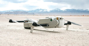
Drone Delivery Canada (DDC) is in the process of merging with Volatus to bring a combined service and equipment capability to market. Both companies are currently listed on the Toronto Stock Exchange and will trade under DDC’s stock symbol “FLT” following the completion of the merger, anticipated by the end of Q3 2024. DDC provides a unique Condor cargo UAV capability, remote operations center, cargo infrastructure and operations software, while Volatus provides UAV services, training and equipment sales to enable a path to market for the combined company.
Condor UAVs can carry approximately 400lb of cargo. (Photo: DDC)
Joby has been a leading participant in the emerging eVTOL air-taxi market segment, and acquired radar developer Inras GmbH in Linz, Austria in December 2021. The small Inras team brought advanced radar technology to Joby’s eVTOL development to provide onboard sensing and navigation.
Now Joby has also acquired the autonomy division of Xwing, which brings, according to the Joby website, “autonomy, including vision system processing, detect and avoid algorithms, mission management and decision making, ground control stations, remote operations and also the integration of Artificial Intelligence (AI) and machine learning algorithms.”
Joby’s two flying pre-production eVTOL aircraft (Photo: Joby)
The Xwing Superpilot software has previously enabled autonomous ‘gate-to-gate’ flight, 250 self-contained flights and 500 auto-landings with a Cessna 208B Grand Caravan for demonstration/tests. This system resulted in an official project designation for the certification of a large unmanned aircraft system (UAS) by the Federal Aviation Administration (FAA) in April 2023, and an Air Force Military Flight Release in 2024. Joby expects the acquisition to not only further long-term autonomous civilian capability — initial FAA certification is anticipated with piloted aircraft — but also to support existing and future business with the United States Department of Defense (DOD).
Meanwhile, Airbus is taking a similar approach by teaming with Helsing in Europe to integrate AI into a future Airbus unmanned Wingman concept aircraft — a UAV designed to fly with and be controlled by front-line manned fighter aircraft. Alongside growing European force requirements, Airbus envisages a lower-cost, attributable, UAV commanded by manned aircraft that could dispatch the Wingman for target reconnaissance and destruction or electronic jamming and deception of enemy air defense systems.
Airbus and Helsing CEOs with Wingman model.(Photo: Airbus)
Both Joby and its rival Archer have also received FAA Part 135 certification, which allows them both to run an air-taxi operation. Neither has yet obtained FAA authorization for their eVTOL aircraft, but both appear to have a clear mandate from the FAA for the steps necessary for those certifications. Both intend to operate existing certified fixed-wing aircraft as air taxis in the meantime under the Part 135 authorization.
While browsing through the FAA’s Special Class Airworthiness Criteria for the Joby Aero Model JAS4-1 Powered-Lift, published on the Federal Register, I learned that the task to certify a brand-new category of aircraft is huge — not big, absolutely gigantic.
FAA put together a draft of proposed cert criteria and put it out for comments to interested government agencies and industry — a whole slew of comments were received, which the FAA reviewed. The FAA incorporated some and discarded others. Just the response to these comments goes on for many pages — there were a lot of comments. Nevertheless, just skimming through FAA’s responses to these comments was a significant undertaking, never mind reviewing and understanding the basic requirements for, say, the two-performance option. Imagine what eVTOL operators have to go through to demonstrate that they meet the steps to achieve FAA certification.
The cert basis for Joby appears to be a combination of fixed wing and helicopter requirements, plus more to address the novel electrical propulsion system and the batteries that provide its power. Two levels of performance standards are set out — an “essential” level and an “increased” level. The 42 organizations that commented on the draft requirements included worldwide aviation agencies, eVTOL and aircraft companies, industry associations and major components suppliers, the Association for Uncrewed Vehicle Systems International (AUVSI) and some individuals — a huge group of involved and impacted organizations.
Joby applied to the FAA in November 2018 for certification of its Model JAS4-1 powered-lift eVTOL. Joby has been supporting just the activity related to certification for six years to date. All the other eVTOL developers are at a very similar stage as they try to get their aircraft into service carrying people and generating income.
Most eVTOL developers have major sponsors familiar with the certification process. Otherwise, the effort would just be too costly, never mind the cost of proving the capability to operating customers, the country as a whole and capturing the imagination of intended users. Plus, of course, building and qualifying the test vehicles, and the operational infrastructure to allow these eVTOLs to land, pick up customers and fly them to somewhere near their destination. The length of time to do this over so many years has broken many unwitting start-up companies. Achieving this goal can be incredibly difficult without the substantial financial resources of major companies such as Airbus, Boeing, or major airlines.
Moving from UAV to passenger airplane is something not to be taken lightly. As a potential future passenger, just keep waiting for your first flight in an operational certified eVTOL. Several of the contenders have targeted 2026, but who knows? I wish them the best of fortune and they’ll need it!
Wingtra has released its WingtraCLOUD software, designed to simplify data collection and streamline the onboarding of surveyors and pilots.
WingtraCLOUD offers a user-friendly flight planning experience, plus time-saving features including site-based file organization, advanced 3D planning, coordinate system by sites and improved connectivity via cloud syncing in a single environment.
It aims to simplify and streamline site setup and team collaboration. WingtraCLOUD’s features simplify and accelerate planning and introduce a new level of transparency among stakeholders with enhanced wireless functionality. Users can now provide insights to regional and global site managers across projects.
WingtraCLOUD allows users to maximize Wingtra aerial data and services, offering UAV program scaling and business advantages across a variety of industries.
A roundup of recent products in the GNSS and inertial positioning industry from the June 2024 issue of GPS World magazine.
SURVEYING & MAPPING
Upgraded surveying software With an improved CAD engine
Survey Master 3.5.0 includes an enhanced CAD engine. A measurement grade has been added to the CAD to improve the software’s utility in design and planning projects. Additionally, the latest version features expanded CAD drawing and survey functions to offer users a comprehensive toolset — including point, line, polyline, curve, arc, square, rectangle, polygon, circle and text. Survey Master 3.5.0 features CAD capture mode from any point and allows users to easily display or hide point icons.
The system added the Dominican predefined coordinate system, SBAS configuration, PPP and RTK PPP fusion, updated satellite frequencies and an external datalink CDL7 configuration. Existing software users can update directly in Survey Master. Comnav Technologies, comnavtech.com
Scanning kit Combines photogrammetry with RTK precision
The Pix4D & Emlid Scanning kit combines advanced photogrammetry with real-time kinematics (RTK) precision for quick data capture when documenting trenches and as-builts, performing volumetric measurements and enhancing aerial data with terrestrial scans. It includes the PIX4Dcatch app and the Emlid Reach RX RTK rover.
The PIX4Dcatch app allows precise scanning for both photogrammetry and lidar projects. The hardware features the Emlid Reach RX RTK rover, which comes with an ergonomic handle and accessories. It is integrated with PIX4Dcatch and provides real-time positioning through NTRIP.
The kit works with any correction network or GNSS base station broadcasting RTCM3. The rover gets a fix in less than five seconds, offering centimeter-accurate positioning in challenging conditions. It can also be used with the survey pole as an RTK rover for data collection and stakeout.
Designed for urban surveying, the Reach RX rover is lightweight, rated IP68, sealed and protected from water and dust.
The PIX4Dcatch mobile app allows users to use a smartphone for scanning, access RTK precision data through integration with Reach RX and generate a digital model within minutes. Users can also store, annotate, measure and share data online in PIX4Dcloud as well as verify geolocated positions and visualize the project in AR. It extracts insights from both terrestrial and aerial data and features online and offline processing, advanced photogrammetry capabilities, team collaboration and AR for CAD overlays. Emlid, emlid.com
UAV surveying software Now with planimetric survey capabilities
Virtual Surveyor version 9.5 is a smart UAV surveying program featuring new planimetric survey capabilities. Users can survey 2D features from UAV orthophotos and add them to a 3D topographic model generated from the same data set.
The integrated Terrain Creator app photogrammetrically processes UAV photos to build survey-grade digital surface models (DSMs) and orthomosaics. These transfer seamlessly to the traditional Virtual Surveyor app where users can generate CAD models, create cut-and-fill maps and gather other 3D topographic information.
No third-party software is needed to create surveys from UAV data. The system is ideal for users in construction, surface mining and excavation projects. Virtual Surveyor, virtual-surveyor.com
RTK technology For GIS needs
RTK Torch is designed for high-precision geolocation and GIS needs. It has tri-band reception and tilt compensation.
The RTK Torch can provide millimeter-grade measurements. Users can connect a phone to the device over Bluetooth and receive the NMEA output and work with most GIS software.
The RTK Torch features Zero-Touch RTK technology, which gives connected devices WiFi credentials for a hotspot or other WiFi network. The device will begin receiving corrections without any further setup, with no NTRIP credentials required. These corrections are obtained over WiFi from u-blox PointPerfect and are available in the United States, Europe and various parts of Australia, Canada, Brazil and Korea.
The RTK Torch includes a one-month free subscription to PointPerfect. Additional subscriptions can be purchased if desired. If PointPerfect coverage is not available in the area, corrections from a local base station or service can be provided to the device over NTRIP, delivered via Bluetooth or WiFi.
It is housed in an IP67-rated enclosure. It is waterproof when submerged up to 1 m for up to 30 minutes when the USB cover is closed. Under the hood of the SparkFun RTK Torch is an ESP32, a UM980 L1/L2/L5 high precision GNSS receiver from Unicore, and an IM-19 for tilt compensation. The addition of the L5 reception makes this portable GNSS device ideal for densely canopied areas where normal L1/L2 reception may have problems. SparkFun, sparkfun.com
3D laser scanner
For indoor and outdoor mapping
The VZ-600i terrestrial laser scanner offers a broad range capability from 0.5 m up to 1,000 m and is suitable for indoor and outdoor 3D mapping applications. It features 3D position accuracy of 3 mm, less than 30 sec scan time for high-resolution scans with 6 mm point spacing at 10 m, weight less than 6 kg (13 lbs), 2.2 MHZ PRR, three internal cameras and is GNSS integrated.
Designed for mobile mapping applications, the system is suitable for architecture, engineering and construction (AEC), building information modeling (BIM), as-built surveying, forensic and crash scene investigation, archeology, forestry and more. RIEGL, riegl.com
OEM
Application suite
Featuring GRIT Technology
The NovAtel Application Suite Version 2.0 now includes GNSS Resilience and Integrity Technology (GRIT). The GRIT Monitor application allows users to observe radio frequency (RF) interference through a comprehensive dashboard to make informed decisions to maintain robust positioning.
GRIT is RF interference detection and mitigation technology available on all OEM7 GNSS receiver products, including individual cards and enclosures such as smart antennas, PwrPak and MarinePak.
It includes positioning and device status overviews to serve as a mitigation assistant that indicates whether interference is detected. It features an interactive spectrum viewer, which shows all constellations and frequency bands (spectrum and waterfall), and a signal matrix indicating the signal quality and interference status by frequency band and constellation.
The updated suite also introduces firmware compatibility and improvements to the user interface and extends support to include MarinePak, among other enhancements. The Manage application, previously known as Setup and Monitor, now supports satellite tracking for L-Band and SBAS and offers a global map view of connected receivers.
Version 2.0 of the NovAtel Application Suite is designed to assist users in maintaining accurate GNSS positioning by quickly identifying and responding to RF interference. This update is targeted to industries that require precise location data, such as aerial mapping, agriculture and autonomous vehicle navigation. NovAtel, novatel.com
DEFENSE
Upgraded UAS
With silent VTOL capabilities
The VXE30 Stalker unmanned aerial system (UAS) features the new “Havoc” configuration, designed to double the system’s flight endurance and payload capacity.
With the Havoc upgrades, the VXE30 can now support the complex demands of both small tactical units and larger brigade-level operations without extensive reconfiguration. The upgrades are designed to make the UAS more versatile across various military applications.
The VXE30 Stalker UAS has silent, vertical take-off and landing (VTOL) capabilities and is payload agnostic with the Havoc configuration. It supports easy integration of third-party payloads and subsystems through a Modular Open Systems Approach (MOSA), requiring no additional training for current operators. Edge Autonomy, edgeautonomy.io
CUAS technology Adheres to NDAA standards
This counter-unmanned aircraft system (CUAS) is a high-speed kinetic interceptor UAS that utilizes advanced autopilot algorithms for calculating and tracking precise target trajectories, neutralizing Group 1 and 2 aerial threats with pinpoint accuracy.
The system is manufactured in accordance with the National Defense Authorization Act (NDAA) to ensure it meets the federal requirements necessary for immediate deployment in both military and industrial settings in the United States. Nearthlab, nearthlab.com
GPS integrity module Seamlessly integrates with existing platforms
The Shift5 GPS integrity module is a platform-agnostic solution for military, aviation, rail, maritime and space applications.
With real-time access and analysis of onboard data, the module assesses changes in navigational position through multi-faceted anomaly detection methods, which alert operators to GPS spoofing attacks as they happen.
Using data collected from onboard systems, the module uses algorithmic position analysis to identify significant position deviations and GPS data validation to verify GPS information accuracy. Discrepancies or deviations that indicate tampering trigger an immediate notification, allowing operators to initiate standard operating procedures (SOPs) rapidly and accurately.
The module is designed for cross-platform deployment, across commercial and military planes, locomotives, vessels and aircraft, as well as on other critical systems such as radar, unmanned aircraft systems (UAS) and weapon guidance systems. It seamlessly integrates with existing platforms and can deploy directly to onboard hardware.
It offers multi-faceted detection and alerts for GPS spoofing attempts, designed to improve the safety and reliability of navigation systems. It uses physics-based spoofing detection to determine whether reported changes in position are physically possible to provide an effective method for initial spoofing detection. The system analyzes data from all sources to detect subtle, sophisticated spoofing attempts, which is essential for identifying more complex spoofing strategies that may evade traditional spoofing detection techniques.
Shift5 alerts can be integrated into existing SOPs to help preempt contamination of other positioning and navigation data, such as inertial navigation calibration against false GPS data. Metadata about the time, location, duration and estimated position of the attack can be passed for inclusion in threat mapping and other geospatial systems for future route avoidance. Shift5, shift5.io
VTOL UAS Designed for military forces
The Rogue 1 loitering munition UAS is designed to provide military forces with enhanced versatility, survivability and lethality in modern combat environments.
The Rogue 1 is an optionally lethal, vertical takeoff and landing (VTOL) capable of engaging both moving and stationary targets, including armored vehicles and dismounted threats. It features a unique mechanical interrupt fuzing system that allows for the drone to be safely recovered and reused if the mission is aborted or targets are disengaged.
Equipped with advanced electro-optical and FLIR Boson 640+ thermal cameras, Rogue 1 offers day and night long-range reconnaissance and surveillance capabilities. The system’s gimballed payload allows for precise targeting, facilitated by a novel coupling between sensors and warhead. Operators can customize the munition with various modular, mission-specific payloads to effectively engage different types of enemy targets.
It has a flight time of 30 minutes, can reach burst speeds exceeding 70 mph and has an operational range of over six miles, making it suitable for missions in harsh battlefield conditions, including communication- and GPS-denied environments. TeledyneFLIR Defense, flir.com
UAV
Delivery winch Improves safety and operational capabilities
A2Z Drone Delivery has released new safety features and hardware upgrades for its RDS2 commercial UAV delivery winch, including a weatherproof cover and an auto-releasing bag hook. This aims to improve safety and operational capabilities as well as aid in regulatory compliance for beyond-visual-line-of-sight (BVLOS) operations.
The system features entanglement auto-detection, which autonomously detects tether entanglements and allows the system to safely abandon the tether to prevent damage to the UAV. This feature can be customized to recognize different types of obstructions, whether at altitude or during the landing phase, enhancing safety across a variety of operational scenarios.
Additionally, the overweight payload rejection feature ensures that the payload weight does not exceed the 5 kg limit. This is useful when picking up payloads from third parties, as it automatically confirms that the weights are within safe flying limits before proceeding with the mission. The RDS2 now includes Tether Lifecycle Alerts, which notify operators when the winch’s tether, rated for up to 800 deliveries, requires replacement. A2Z Drone Delivery, a2zdronedelivery.com
Integration platform For fully autonomous operations
Flinks is designed for one-click integrations with third-party applications and devices. The platform aims to streamline the coordination of various systems involved in UAV operations, creating end-to-end automated workflows for fully autonomous systems.
It allows users to connect the FlytBase platform with critical business systems such as alarm systems, video management, data processing and more. By eliminating the need for complex, time-consuming manual interventions, Flinks is designed for users to seamlessly incorporate autonomous drones into their existing operations.
By joining the Flinks Partner Program, organizations can access FlytBase’s global network of UAV service providers, system integrators and enterprise customers. FlytBase, flytbase.com
MACHINE CONTROL
Antenna Integrates with heavy construction equipment
The iCON 120 machine smart antenna offers scalable and flexible machine control solutions for construction professionals.
The iCON 120 is a GNSS antenna intended for integration within the existing Leica MC1 platform. Using the iCON 120, operators can benefit from a tailor-made, Leica MC1-based machine control, allowing for more streamlined operations and consistent workflows with a variety of heavy construction equipment and application requirements.
Leica iCON 120 users can start with a single GNSS solution using a satellite-based augmentation system (SBAS), such as WAAS or EGNOS, or a HxGN SmartNet service. The HxGN SmartNet family offers network real-time kinematics (RTK) with RTK bridging and precise point positioning (PPP) services that work exclusively with Leica Geosystems GS sensors. The new smart antenna can be easily switched, with quick mounting and dismounting, between Leica MC1-prepared machines.
Users can optionally upgrade their basic-level machine-control solution with the Leica CR50 communication unit to receive RTK correction data via radio or modem. The CR50 features a web interface, automotive ethernet communication, worldwide cellular modem and integrated dual-frequency UHF radio. Leica Geosystems, leica-geosystems.com
GNSS smart antenna For construction Site Positioning
The R780 GNSS Smart Antenna is designed for construction site positioning. It features a dual-band radio (450/900 MHz) that connects to diverse base stations and job sites without additional external radios. The dual Trimble Maxwell 7 GNSS ASIC chip allows the system to perform in challenging GNSS environments such as a blocked sky, multi-path or degraded signal.
An activated and ready-to-use Trimble CenterPoint RTX subscription is included for the first 12 months. CenterPoint RTX is point positioning technology that provides real-time, centimeter-level corrections via satellite or cellular/IP.
Using the R780 with Trimble FieldLink software supports underground and long-distance layout projects as well as QA/QC and field positioning tasks. The R780 can serve as a GNSS rover or as a base station for other GNSS operations including machine control. Trimble Civil Construction, heavyindustry.trimble.com
RapidFlight has been awarded a $10 million contract from the United States Department of the Air Force (DAF) under the AFWERX Autonomy Prime program. Under the contract, RapidFlight will develop and produce the SPX, a customizable, autonomous fixed-wing aircraft system.
The project objective is to design and produce the SPX UAV, featuring a 12 lb. payload capacity, 150 nm range, and a modular payload bay. The RapidFlight Common Avionics 2.0 will be used to support autonomous flight with various payloads.
During the initial phase of the 36-month contract, RapidFlight will design SPX UAVs for testing at the Autonomy Prime Proving Ground. This will be followed by a contractor-owned, contractor-operated (COCO) demonstration at the RapidFlight facility in Manassas, Virginia. Comprehensive training for USAF operators is also included.
Each SPX system includes four airframes, a ground control station, a field kit and a compact launcher. The system’s modular design supports a range of payloads, sensors and autonomy packages for rapid and economical real-world flight testing.
The Federal Aviation Administration (FAA) has granted Amazon Prime Air permission to operate UAVs beyond visual line of sight (BVLOS). This allows Prime Air to expand its UAV delivery service to more customers and scale operations across the U.S.
Prime Air’s BVLOS operations rely on detect-and-avoid technology, which allows UAVs to autonomously navigate obstacles for safe flight operations. Amazon provided the FAA with detailed engineering data and conducted flight demonstrations, which included real-world scenarios involving planes and hot air balloons, to validate the system’s safety.
With this FAA approval, Prime Air will extend its delivery area in College Station, Texas, using its MK-27 UAV. The service will integrate into Amazon’s existing delivery network, with UAVs deploying from facilities adjacent to same-day delivery sites.
Prime Air received an Air Carrier Certificate in 2020. The recent BVLOS approval further extends its capabilities, allowing Amazon to access more densely populated areas. The UAVs aim to deliver packages within 30 minutes or less.
Aircraft operating near Seoul, South Korea spoofed to points in the ocean 28 to 30 May 2024. (Image: SkAI Data Services)
On the morning of May 30, 2024, Benoit Figuet posted on X that 40 aircraft operating into and out of South Korea had been spoofed over the previous 18 hours.
Professor Jiwon Seo at South Korea’s Yonsei University reports that the interference has, as of June 3, entered its fifth consecutive day.
Benoit Figuet is the co-founder of SkAI Data Services in Zurich, Switzerland. In collaboration with the Zurich University of Applied Sciences, SkAI created the world’s first public Live GPS Spoofing Tracker website. The site uses ADS-B data to detect and display in near-real time, aircraft being spoofed around the world.
South Korean military authorities have identified North Korea as the source of interference.
While the spoofing exhibits many of the same traits as interference in the Black Sea and elsewhere, Figuet has noted some differences. “We even see aircraft impacted at low altitudes,” he said. “We have observed this happening below 5,000 feet and even affecting an aircraft taxiing on the ground at the airport. The source must be at a reasonably high elevation or fairly close by.”
North Korea has a history of engaging in hybrid, non-kinetic warfare by interfering with GPS in the South, though this is the first large-scale event since one lasting from March 31 through April 5, 2016.
During the 2016 event, five different locations along the border of South Korea were identified as sources of interference. One is at an elevation of approximately 740 m and only 30 km from Inchon International Airport.
Another unique feature of the ongoing interference, according to Figuet, is the dynamic nature of the spoofed location. Unlike previously observed “circle spoofing,” the reported locations generally appear as tracing a figure eight pattern in the ocean near a point where the territorial seas of both countries meet.
Some of the spoofed locations have also been observed drifting over the North Korean border.
Local media have reported that the interference seems to be in conjunction with maritime maneuvers being conducted by the South Korean Navy and police vessels. The North has complained about intrusions into its territorial sea during these operations, a claim disputed by South Korea.
To help counter the effects of the North’s interference, South Korea has added to and upgraded its eLoran system. It has also included the eLoran upgrade in a comprehensive resilient PNT architecture that includes television signals and plans for a regional positioning, navigation and timing (PNT) satellite system.
According to Pyo-Woong Son, Ph.D., “South Korea is set to enhance its navigation and service reliability with the fully operational and established eLoran system. This system is expected to ensure that ships can navigate safely even during large-scale GPS signal disruptions, like those the country has recently experienced.” Son is a Senior Researcher at the Korea Research Institute of Ships and Ocean Engineering.
“In addition to maritime applications, eLoran will significantly contribute to the reliable operation of autonomous vehicles, such as urban air mobility (UAM), which are rapidly gaining popularity as future modes of transportation.”
“Furthermore, eLoran will play a crucial role in enhancing the reliability of public and private sector services, including broadcasting, telecommunications, and finance, where precise timing synchronization is essential,” according to Son.
Loran-C was used in many aircraft for decades before the advent of GPS. While eLoran signals are available across most of the Far East, receivers are not included in the navigation suites of commercial aircraft.
Aircraft operating into and out of Incheon International Airport have, so far, been able to use local terrestrial aviation-specific navigation aids to safely approach, land and depart.
Mr. Dana A. Goward is President of the Resilient Navigation and Timing Foundation and is a frequent contributor to GPS World.
The Baltic, Ukraine, and the Middle East may be hotbeds of GPS interference that can hamper UAV operations, but these are not the only places in the world where it is happening.
It also happened in San Diego at the premier event for UAV operators— the XPOTENTIAL 2024 conference of the Association for Uncrewed Vehicle Systems International (AUVSI).
AUVSI is the world’s largest nonprofit organization dedicated to the advancement of uncrewed systems and robotics. Members present included corporations and professionals from more than 60 countries involved in industry, government and academia and work in the defense, civil and commercial markets.
One of NavtechGPS’ directional finder identifies the source of interference at AUVSI’s Xpotential 2024 in San Diego. (Image: Dana Goward)
Among conference attendees were Franck and Trevor Boynton of NavtechGPS, a small Northern Virginia company specializing in GPS products and related services. One of their services is locating devices that are interfering with GPS reception.
“In our work around the country we have found a wide variety of devices interfering with GPS,” said Franck Boynton. “It’s a lot more common than you think. We found truckers with jammers interfering with port operations, for example,” he said. “But accidental interference is an even bigger problem. Most of the time we find it is just some malfunctioning equipment making the radio noise.”
Boynton’s experience is consistent with the 2019 European Union STIKE3 sampling project that detected more than 450,000 signals with the potential to interfere with GPS and other satnav signals. Experts determined that only about 10% of those were intentional. The rest seemed to be a byproduct of mechanical and electrical equipment not functioning quite properly.
Of course, intentional or accidental, interference with GPS signals can be a problem for both manned and unmanned aircraft, vessels and vehicles.
Intentional interference in conflict areas has turned UAVs and missiles away from their targets, and in some cases, back on attackers. It has impacted the safety and efficiency of aviation and maritime traffic nearby. As one example, regular jamming in the Baltic region recently resulted in the cancellation of scheduled commercial air service to a city in Estonia.
Accidental interference has caused survey UAVs to crash and created multi-day problems at the Denver and Dallas-Fort Worth major airports.
In at least one instance accidental interference almost ended in tragedy. In 2019 a commercial passenger aircraft near Sun Valley, Idaho nearly crashed into a mountain. Fortunately, a sharp-eyed radar controller hundreds of miles away intervened and directed the aircraft back on course.
Nearly 600 vendors filled the AUVSI XPOTENTIAL exhibit hall this year. While perusing the displays, the Boyntons detected a strong signal interfering with GPS frequencies. Thinking it was coming from one of the exhibits, they were surprised to find that not only did it turn off and on but it seemed to be moving around.
Using one of the direction finders that NavtechGPS sells, they were able to track the source to a film crew roaming the hall and speaking with exhibitors and attendees. The wireless microphone being used for interviews turned out to be the culprit. Since the film crew was unable to repair or replace the mic, the interference continued intermittently inside the hall for the rest of the event.
“Interference of all kinds with GPS and other satnav signals is a growing problem,” according to Franck Boynton. “As we continue to implement more autonomous systems, it will be increasingly important to ensure they have resilient navigation, and we eliminate as many sources of interference as possible.”
AUVSI did not respond to requests for comment for this story.
A roundup of recent products in the GNSS and inertial positioning industry from the May 2024 issue of GPS World magazine.
SURVEY & MAPPING
Photo: Virtual Surveyor
UAV With planimetric survey capabilities
The Virtual Surveyor version 9.5 now allows users to quickly and accurately survey 2D features from UAV orthophotos and add them to the 3D topographic model generated from the same data set.
True 2D features, for example, include the paint striping that delineates parking lot spaces and road lanes. Other objects that exist in 3D on the ground but can be surveyed in two dimensions include building footprints and tree canopies. These features are designed to offer a new level of efficiency to the UAV surveying process in Virtual Surveyor.
Virtual Surveyor provides users with an end-to-end workflow to conduct 3D surveys from UAV imagery. The integrated Terrain Creator app photogrammetrically processes UAV photos to build survey-grade digital surface models (DSMs) and orthomosaics. No third-party software is needed to create surveys from UAV data. The system is ideal for users in construction, surface mining and excavation projects.
Positioning System Incorporates an anti-jamming and interference monitoring system
SXblue GLOBE merges GNSS and GIS to deliver positioning accuracy, efficiency and reliability in challenging field conditions using a 448-channel GNSS board.
Its advanced multipath mitigation aims to reduce the effects of signal reflection and ensure the integrity of positioning service, even in GNSS-challenged environments. The SXblue GLOBE incorporates an anti-jamming and interference monitoring system, safeguarding against disruptions and offering uninterrupted operation in any scenario.
The system uses global or local coverage of correction services, satellite-based augmentation system (SBAS), and real-time kinematics (RTK) with an update rate of up to 100Hz. This seeks to provide users with enhanced accuracy and reliability in positioning activities. Sxblue GLOBE features a Wi-Fi connection, which allows its parameters to be easily configured via a web user interface.
3D Mapping Software With expanded visualization tools
The Surfer mapping and 3D visualization software now features upgraded 3D visualization capabilities. The upgrades are designed to give users a complete picture of collected subsurface data. The expanded visualization tools in the latest Surfer version make it easier to create 3D grid files for viewing and analysis of drillhole data.
Surfer can be used for environmental consulting, water resources, engineering, mining, oil and gas exploration and geospatial projects.
With these upgrades, users can render 3D grids as a series of blocks, which can be colorized by a select variable. Images of cross sections, profiles and other features can be imported directly into 3D View and oriented in any direction or angle. To isolate certain features in the 3D grid, users can assign NoData to portions of the grid with a variety of methods. This allows users to eliminate unwanted data in a 3D grid outside of field boundaries, well locations, or above or below specific surfaces, such as a water table, topography, or lithologic layer.
Digital Twin Platform Shows roadway incidents in real time
The Flow RT is a real-time digital twin platform designed to provide agencies with instantaneous alerts and insights for better decision-making. The platform allows traffic managers to view traffic conditions, signal operations and roadway incidents in real time, at scale across entire regions.
Flow RT integrates seamlessly with the company’s solutions, including traffic signal management, roadway safety management and mobility management. Powered by connected vehicle data from industry-leading partners, including TomTom, the platform offers up to five times higher vehicle data penetration rate than the previous industry standard. Flow RT also provides alerts and notifications while offering data-driven decision support, ensuring agencies can make the best decisions using the most accurate, reliable and instantaneous insights with and without infrastructure connectivity.
INS With an integrated acoustic resonance air speed sensor
Inertial Labs has integrated the FT Technologies FT743-D-SM acoustic resonance air speed sensor into its inertial navigation systems (INS).
This integration aims to improve the accuracy of horizontal air speed estimation for multi-rotor UAVs, even in GNSS-denied environments. The FT743-D-SM airspeed sensor is a digital anemometer-based solution that can estimate airspeed incoming from any direction using acoustic resonance technology, which is immune to vibration and external acoustic noise. The airspeed magnitude and direction allow the INS to estimate horizontal air speed in the longitudinal and lateral axes.
The INS receives aiding data from the dual-axis airspeed sensor and experiences significantly less position drift compared to a dead reckoning alternative in GNSS-denied environments, the company said. The system can be used in mission-critical roles in multiple military or defense applications, as well as in civilian applications such as wind energy, marine navigation, UAVs and dynamic positioning systems.
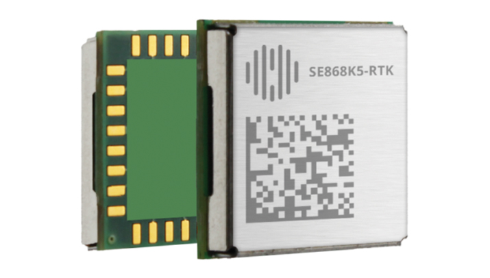
The SE868K5-RTK module is a GNSS receiver capable of centimeter-level accuracy. It is designed for seamless operation near cellular or other radios and is suitable for precision applications.
At 11 x 11 mm, the module’s compact form factor offers adaptability in size-constrained scenarios and easy migration within the xE868 product family. It is designed to offer high-performance navigation, even in challenging RF conditions. The solution can be integrated into applications such as wearables, UAVs, robots, fleet tracking and precision agriculture.
The SE868K5-RTK is a multifrequency and multi-constellation positioning receiver module with RTK capabilities that enhance positioning accuracy. By harnessing dual frequencies — L1/E1 and L5/E5 — the module offers improved location precision and reduces multipath effects.
In partnership with Swift Navigation, the SE868K5-RTK module utilizes local base stations or Swift’s Skylark precise positioning service for corrections, which offers reliable centimeter-level accuracy across an extensive coverage area. The integration and Telit Cinterion’s cellular modules and NExT connectivity services offer continuous and accurate correction data delivery to the GNSS module.
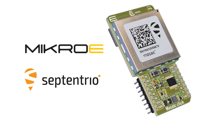
Upgraded Click Board Now with an integrated GNSS receiver module
The Septentrio mosaic-X5 GNSS receiver has been integrated into the MikroElektronika (MIKROE) Mosaic Click board.
Mosaic Click is compatible with mikroBUS socket standard, allowing plug-and-play prototyping and reduced time-to-market. The mosaic-X5 receiver uses triple-band GNSS technology to achieve centimeter-level RTK accuracy, even in challenging environments. Its anti-jamming and anti-spoofing technology protects the receiver from malicious or accidental radio interference. It is ideal for applications where safety is a concern, as well as autonomous and mission-critical applications of systems such as UAVs or industrial robots.
The mosaic-X5 receiver tracks all available GNSS constellations and is protected by Septentrio’s AIM+ anti-jamming and anti-spoofing technology. Full GNSS raw data and positioning are delivered at a high update rate of 100Hz and with low latency, which is critical for autonomous movement and maneuvering.
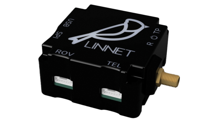
RTK Positioning Module Supports all GNSS constellations
The Linnet mosaic-X5 is a multi-band module featuring the Mosaic-X5 receiver by Septentrio. It receives signals from all major constellations and can be used both directly on the rover and as a base station. The system can achieve centimeter-level positioning accuracy and attain precise positioning even in low-coverage zones and harsh vibrations and shocks.
The mosaic-X5 module is a 448 channels all-in-view receiver that supports all GNSS constellations, SBAS and QZSS, as well as built-in on-module support for other L-band correction services. The Linnet Mosaic-X5 features anti-jamming protection and anti-spoofing built-in and embedded spectrum analyzer.
The module can be used in a variety of applications, including tracking, surveying, autonomous navigation, ground robotics, precision agriculture and machine control.
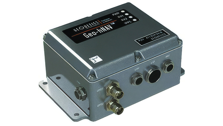
Geo-hNAV is a rugged, hybrid dual-GPS-aided INS. It offers consistent position and attitude measurement accuracy whether the platform is static or moving. The Geo-hNAV combines the Geo-iNAV INS with the Geo-Pointer dual-antenna heading system.
For stationary or slowly moving platforms, precise heading is derived from GPS measurements using two GPS antennas rigidly mounted on the platform, separated by a typical distance of 1 to 3 meters. In dynamic conditions, the combination of GPS and IMU seeks to provide enhanced position, velocity and attitude measurements. The system can be used for geo-positioning onboard sensors on static, low and high dynamic platforms such as aerostats, boats and tanks.
The C631 is a multi-GNSS, multi-frequency smart antenna. The C631 provides robust performance and high precision in a compact and rugged package. With multiple wireless communication ports and an open GNSS interface, the C631 can be used in a variety of operating modes.
C631 can be used as a precise base station sending RTK to existing rover networks. Users can turn the C631 into a lightweight rover by connecting it to a base via UHF radio or Wi-Fi network. The built-in web user interface can be used to control and manage the receiver status and operation and upgrade the C631 with new firmware and activations.
Atlas is a global correction service that can be added as a subscription to the C631. Atlas delivers worldwide centimeter-level correction data over L-band communication satellites.
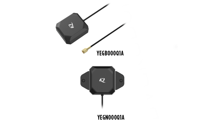
The YEGB000Q1A and YEGN000Q1A active GNSS L1 and L5 antennas are designed to tap into L1 and L5 frequency bands for advanced navigation applications. These antennas, operating within the 1164-1189 MHz and 1559-1606 MHz frequency bands, are designed to support a variety of installation methods, catering to diverse application needs with options for screw mount, adhesive mount, magnetic mount and various cable connections.
The antennas are part of a broader release that includes the YEMN016AA and YEMN017AA 5G 5-in-1 combination antennas, which also feature GNSS capabilities.
These GNSS antennas are crucial for applications that require high levels of navigation accuracy, such as autonomous vehicles, UAV delivery systems and precision farming.
The TW5387 industrial-grade smart GNSS antenna integrates the Quectel ST TESEO V GNSS receiver chipset onto the Calian compact smart GNSS antenna platform. It is designed to offer dual-band GNSS, eXtended filtering, low phase center variation, low signal-to-noise ratio and dual feed and patch for strong multi-path rejection.
The TW5387 comes with RTK rover capability and a built-in IMU for sensor fusion. It is designed to minimize RF impairments that affect the performance of the GNSS receiver and provide GNSS coordinates to the host system over a robust digital interface for noise resilience.
TW5387 is suited for automotive, UAV, robotics and defense applications that require high precision location and timing. TW5387 is compatible with N-RTK correction services such as Point One Navigation’s Polaris and Swift Navigation’s Skylark. It tracks GPS, Galileo, BeiDou and L1/L5 band operation and is housed in an industrial-grade IP69K enclosure.
The PEANGPS1005 is an active GPS/GNSS multi band L1/L2/L5 antenna with 47.5 dBi overall gain. It is IP69K rated, light weight and designed for surveying. This GPS/GNSS antenna is suited for harsh operating environments where stability and reliability of GPS/GNSS signal is required.
This antenna operates in the 1.164-1.3GHz and 1.525-1.615GHz bands, meeting GPS L1/L2/L5, GALILEO E1/E6/E5a/E5b and GLONASS L1/L2/L3 requirements. The PEANGPS1005 antenna has an integrated LNA with 2 dB noise figure and LNA gain of 40 dB.
The antenna has an axial ratio of 3 dB and can track visible satellites under extreme conditions, which is ideal for UAV navigation, autonomous tracking or GIS surveying.
Paving and Mining Solution Meets DOT smoothness standards
The MC-Max asphalt paving and MC-Max milling solutions offer modularity, simplified configurations and advanced feature sets to increase productivity in asphalt paving and cold milling applications.
The MC-Max Asphalt Paving and MC-Max Milling systems, which are made up of , total stations, displays and other high-precision sensors, are built with the new MC-X machine control platform. Users can choose from entry-level 2D systems that follow a reference, such as a string or a curb, or automated solutions that track a paver or miller in 3D.
Contractors can pave and mill at variable depths while meeting smoothness standards mandated by the U.S. Department of Transportation (DOT) smoothness standards. The solutions also include MC-X licensing options. The technology is compatible with OEM CAN-based systems and has expanded to include compatibility with additional aftermarket systems.
It is equipped with Topcon Virtual Ski intelligence software designed to simplify workflows in specific resurfacing applications, such as rural roads where there are fewer fixed points or intersections to match up to.
Reality Capture Platform Generates detailed 2D and 3D models
This UAV reality capture platform collects data through FlytBase UAVs and generates detailed 2D and 3D models on SkyeBrowse, a UAV reality capture platform.
The platform uses SkyeBrowse’s videogrammetry technology to quicly convert UAV video footage into 2D maps and 3D models, making it ideal for emergency response scenarios where rapid documentation is critical. The platform integrates seamlessly with beyond visual line of sight (BVLOS) systems, enhancing both the speed and quality of data-driven strategies in critical operations.
The E400 fixed-wing VTOL ISR UAV now features a 360° camera option. Partnering with NextVision, the Event 38 UAV now offers a range of EO/IR Gimbal camera options for seamless integration with the E400 platform.
NextVision’s gimballed EO/IR cameras capture visual and thermal imagery and video. The UAV provides live streaming directly to ground stations for continuous monitoring capabilities.
The 360° EO/IR camera integrated onto the E400 ISR can be used for search-and-rescue missions, suspect pursuit, emergency management and disaster response. The E400 ISR, built with a military-grade carbon fiber frame, offers durability for rugged field applications and allows for extended flight durations without the need for frequent recharging. It is suited for surveillance and security applications. It features electric propulsion and minimal noise emissions for discreet flight operations.
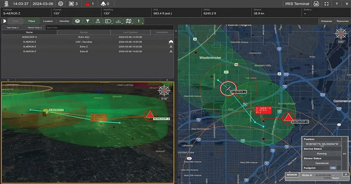
Enhanced BVLOS System Offers situational awareness to UAS operators
IRIS Terminal now features Echodyne radar technology designed to enhance Beyond Visual Line of Sight (BVLOS) operations for unmanned aerial systems (UAS) in Advanced Air Mobility (AAM) applications.
The integration seeks to provide situational awareness to UAS operators by visualizing all airspace movement, cooperative and noncooperative, to ensure safe and reliable UAS operations.
IRIS Terminal, now in its second generation, has been adapted from its defense origins to the enterprise UAS sector for visualizing airspace traffic, as well as controlling uncrewed systems in its GCS format. Airspace traffic is visualized inside IRIS Terminal’s multiple viewing configurations, along with features such as detect-and-avoid (DAA) sensor footprints, terrain awareness and potential conflict warnings.
The Inertial Labs’ RESEPI lidar remote sensing payload instrument GEN-II has been integrated into Sony’s Airpeak UAV.
The partnership seeks to enhance Airpeak’s ability to produce detailed aerial maps and 3D models.
Tailored for professionals, the lidar system integrated into Sony’s Airpeak UAV will significantly enhance workflow efficiency and data accuracy, particularly in sectors such as construction, agriculture, and filmmaking, according to Inertial Labs. The system allows for extensive data handling and facilitates longer durations of data collection without frequent offloads. The UAV can be used for surveying, mapping and cinematic videography.