Tag: autonomous vehicles

  • Unicore: A little robot marks the lines

    Unicore: A little robot marks the lines

    Marking the lines of a soccer field in Vejle, Denmark using a TinyLineMaker Pro X. (Photo. Unicore)
    Marking the lines of a soccer field in Vejle, Denmark using a TinyLineMaker Pro X. (Photo. Unicore)

    Robotic technology is increasingly integrated into daily life, including applications such as delivery vehicles, automated lawn mowers and line painting robots. Among the critical factors shaping the navigation capabilities of these robotic machines, precise positioning and heading are paramount. Leveraging Unicore’s high-precision GNSS real-time kinematics (RTK) module, TinyMobileRobots, a Danish company, has developed advanced autonomous systems that excel in navigating complex environments.

    RTK technology, which greatly compensates for errors in GNSS satellite signals, enables real-time positioning accuracy within 1 cm to
    2 cm. The RTK algorithm in Unicore’s UM960 multi-constellation, multi-frequency GNSS module gives it high reliability, precision and fix rate.

    Sports fields grounds maintenance teams at schools, parks, housing developments and other locations often need to refresh line markings, which is a very labor-intensive and challenging process. In search of a more rapid and efficient solution, the team marking the lines of a soccer field in Vejle, Denmark, opted for TinyMobileRobots’ autonomous system. This system is becoming popular among groundskeeping teams due to its ability to queue multiple pitches for sequential marking without recalibration, maximizing productivity. It also alerts users when it is running low on paint and estimates its remaining time and distance. The enhanced capacity afforded by the robot’s efficiency also allowed the team to explore new service offerings, such as providing line marking services to other organizations.

    The TinyLineMaker Pro X estimates when it will run low on paint and alerts users. (Image: Unicore)
    The TinyLineMaker Pro X estimates when it will run low on paint and alerts users. (Image: Unicore)

    For outdoor robotic applications, GNSS technology’s levels of accuracy range from sub-meter positioning to decimeter and centimeter levels in real time, depending on the specific application. When integrated with complementary sensors such as inertial navigation systems (INS), vision, and radar, robotic navigation can be effectively realized across diverse and complex environments.

  • Autonomy evolves

    Autonomy evolves

    Image: Frontier Precision
    Image: Frontier Precision

    Several technologies — ranging from very mature to nascent — are converging to make autonomous vehicles and devices more useful, efficient, and reliable than ever. They include real-time kinematic (RTK) GNSS, inertial navigation systems (INS), cameras, and radar for navigation; cameras, lidar scanners, multibeam echosounders, and a variety of other sensors for data collection; software-defined radios (SDRs) for secure communications; and artificial intelligence (AI) to plan routes, coordinate the movements of multiple autonomous vehicles and devices (including “swarms” of UAVs), and analyze the data collected.

    Read this cover story, featuring case studies from Unicore and CHCNAV, interviews with executives at Per Vices and M3 Systems, and images from Frontier Precision and YellowScan.

  • Inertial Labs to develop lidar system for Sony UAV

    Inertial Labs to develop lidar system for Sony UAV

    Image: Inertial Labs
    Image: Inertial Labs

    Inertial Labs and Sony have partnered to integrate lidar technology into Sony’s Airpeak UAV. The collaboration aims to improve the UAVs applications in surveying, mapping and cinematic videography, as well as provide high accuracy and detail to aerial data acquisition.  

     The partnership will incorporate Inertial Labs’ RESEPI lidar remote sensing payload instrument GEN-II into Sony’s UAV to enhance Airpeak’s ability to produce detailed aerial maps and 3D models.  

     Tailored for professionals, the lidar system integrated into Sony’s Airpeak drone UAV will significantly enhance workflow efficiency and data accuracy, particularly in sectors such as construction, agriculture, and filmmaking, according to Inertial Labs. The system allows for extensive data handling and facilitates longer durations of data collection without frequent offloads. 


  • GPS disruptions in Tel Aviv as Israel braces for possible Iranian attacks

    GPS disruptions in Tel Aviv as Israel braces for possible Iranian attacks

    Photo: Oren Kfir / iStock / Getty Images Plus / getty Images
    Photo: Oren Kfir / iStock / Getty Images Plus / Getty Images

    On April 4, residents of Tel Aviv, Israel, noticed that map applications on their phones such as Waze, Google Maps and the taxi pickup app Gett were placing them in Lebanon’s capital, Beirut, 130 miles to the north. Cab drivers could not navigate and food-delivery apps were temporarily out of service, reported The Wall Street Journal.

    The spoofing was a result of the Israeli military tampering GPS signals to brace for possible retaliation by Iran or one of its allied militias after a suspected Israeli airstrike on an Iranian diplomatic building in Syria. The attack killed a senior Iranian general, Mohammad Reza Zahedi, and six other military officials. It has marked an escalation of the yearslong conflict between Israel and Iran.

    According to WSJ, analysts say a direct Iranian strike on Israel is unlikely. However, one day after Israel drafted reservists to boost air defenses, the Israeli military said it would pause all leave for combat units “in accordance with the situational assessment.”

    Israel has withdrawn some of its ambassadors and evacuated its embassies in multiple locations. With tensions and uncertainty rising, several Israeli municipalities near Tel Aviv put out announcements to calm residents and refresh guidance for emergencies.

    According to the Israeli military, the GPS spoofing — which can be used to confuse targeting systems for military weapons — was part of an effort to protect the country. “Today we initiated GPS disruption in order to neutralize threats,” said Israeli military spokesman Daniel Hagari. “We are aware that this disruption causes discomfort, but this is an essential and necessary tool in our defense capabilities.”

    Israel has ramped up GPS jamming and spoofing since the start of its war with Hamas in early October 2023, but mainly in the north of the country, where the Iranian-backed Hezbollah militia has rockets to strike Israeli towns and military bases, according to Reuters.

    The military has scrambled signals in southern Israel, mainly around the city of Eilat, the target of missile and UAV attacks by Iranian-backed Yemeni and Iraqi militias, according to Yigal Unna, former director general of the Israel National Cyber Directorate.

    The GPS disruptions have intensified since the most recent strike and have spread to central Israel where a local taxi driver shared that his map application had located him at the Rafic Hariri International Airport in Beirut. In the south of the country, and in Jerusalem and the occupied Palestinian West Bank, GPS devices placed users in Cairo, residents told WSJ.

    Mohammad Abdelhalim, founder of the Palestinian navigation app Doroob, said that signal interruptions have occurred regularly on various platforms that rely on GPS since the Oct. 7 Hamas-led attacks on Israel, ranging from a few minutes to several hours at a time.

    Spoofing can pose risks beyond being a nuisance for citizens. Distorting signals can create challenges for civilian and commercial planes that use GPS signals for navigation. Spoofing can also throw guided missiles off their trajectory, which poses unpredictable risks to civilians.

    The ramifications of the widening GPS blackouts remain unclear. Beyond the hassles for civilian drivers, there are safety concerns for emergency responders and commercial transit unable to reliably track locations.

    The recent spoofing in Tel Aviv is one of countless reminders that the country’s active military actions are only miles away and can have cascading effects on aspects of daily life.

  • EpiSci, Northrop Grumman partner for autonomous defense systems

    EpiSci, Northrop Grumman partner for autonomous defense systems

    Image: EpiSci
    Image: EpiSci

    EpiSci and Northrop Grumman have entered a strategic collaboration to develop and deploy advanced autonomous tactical solutions to the United States and its allies. 

    Under the collaboration, EpiSci’s TacticalAI software will be integrated into Northrop Grumman’s aeronautics system architecture. This integration is anticipated to significantly enhance the operational efficiency and success of warfighter missions through trusted autonomous technologies, according to EpiSci.  

    The collaboration uses the U.S. government’s open-architecture design, allowing Northrop Grumman’s autonomy solutions to incorporate third-party technologies. This allows UAVs to adapt to evolving mission requirements and offers military commanders greater flexibility in complex scenarios.  

    EpiSci’s TacticalAI technology is designed to improve autonomous solutions for human-machine teaming. It offers cognitive sensing, adaptive communications and networking systems, and battle management command and control (BMC2). This technology is being developed to enhance autonomous defense capabilities across a wide range of platforms, including uncrewed aerial and maritime systems, as well as tactical fighter aircraft. 

  • Hexagon, CMC Electronics advance GNSS aviation platform

    Hexagon, CMC Electronics advance GNSS aviation platform

    Image: CNW Group / CMC Electronics
    Image: CNW Group / CMC Electronics

    CMC Electronics has partnered with the Hexagon Autonomy & Positioning division, which includes the Hexagon | NovAtel brand, to release a multi-constellation, multi-frequency (MCMF) GNSS platform.

    The MCMF GNSS platform combines CMC’s certification with the digital signal processing expertise of Hexagon | NovAtel. Designed to detect GNSS signal spoofing, it is lightweight and compact. 

    The increasing threat of GNSS signal jamming and spoofing is not limited to military concerns. It has started to impact global commercial aviation and civilian sectors as well. In response, CMC Electronics and Hexagon | NovAtel seek to introduce a new era of MCMF GNSS positioning and assured positioning, navigation and timing (APNT). The collaboration aims to provide maximum reliability and dependability in solutions for the military, commercial aviation and unmanned aerial systems (UAS) sectors.  

    Under the partnership, CMC Electronics’ new receiver, which is certified to the exacting DO-254 Level A standards, is integrated with Hexagon | NovAtel’s GNSS measurement technology.  

    Based in Montreal, Canada, with additional facilities in the U.S., CMC Electronics designs and manufactures cockpit systems integration, avionics, display solutions and high-performance microelectronics for the military and commercial aviation markets. Hexagon’s Autonomy & Positioning division delivers comprehensive solutions for assured positioning across various applications, designed to progress autonomous technologies in essential industries. 

  • DJI launches drone in a box solution

    DJI launches drone in a box solution

    Image: DJI
    Image: DJI

    DJI has launched the DJI Dock 2. This lightweight drone-in-a-box solution features the Matrice 3D/3TD UAV and is compatible with DJI FlightHub 2, where automated aerial missions can be managed and monitored through cloud-based operations. DJI Dock 2 can streamline daily operations for surveying, inspections, asset management and security.  

     DJI Dock 2 weighs 75 lbs and is 75% smaller and 68% lighter than the previous generation. It uses vision sensors to evaluate a site before deploying the UAV to ensure the flight path and destination have good GNSS signals. This speeds up the site selection process to 12 minutes or less, down from five hours. Once ready, it can quickly complete propeller inspections and get accurate return-to-home (RTH) location information using its dual real-time kinematics (RTK) antennas, which allow the UAV to take off within a minute. 

     The solution can operate steadily in harsh climates and GNSS environments. It is IP55-rated for dust and water resistance and uses gauges for rainfall, wind speed and temperature to sense real-time weather changes. With DJI FlightHub 2 and its integrated online weather forecasting, timely warnings can be issued and flights can be terminated as needed.

    Image: DJI
    Image: DJI

     It can be programmed to complete missions automatically, but at any time, operators can control the flight and gimbal angle from any location. Internal and external fisheye lenses provide real-time conditions within and outside the dock, allowing operators to remotely observe weather conditions, environmental circumstances and takeoff and landing situations.  

  • Seen & Heard: UAVs to the rescue, fire strikes in Chile

    Seen & Heard: UAVs to the rescue, fire strikes in Chile

    “Seen & Heard” is a monthly feature of GPS World magazine, traveling the world to capture interesting and unusual news stories involving the GNSS/PNT industry.


    Photo: ChristinaFelsing / iStock / Getty Images Plus / Getty Images
    Photo: ChristinaFelsing / iStock / Getty Images Plus / Getty Images

    UAVs to the rescue

    A child reported missing in Robbinsville, N.J., was found in less than 10 minutes using a UAV equipped with a thermal camera, WPVI reported.

    On the night of January 17, Robbinsville Police received a call reporting a missing child last seen running into a heavily wooded area. Officers dispatched the department’s UAV equipped with thermal imaging cameras, which allowed officers to quickly locate the missing boy through thick vegetation after dark. The child was unharmed, according to the report.


    Photo: Maxar Technologies
    Photo: Maxar Technologies

    Fire strikes Chile

    Maxar Technologies has released satellite images showing the widespread damage caused by raging wildfires in Chile’s Valparaíso region. The fires have killed more than 122 people. The images show entire neighborhoods destroyed east of the resort town of Viña del Mar yet do not show active wildfires. The fires reportedly surged in the Valparaíso region, fueled by winds and an intense heatwave that has seen temperatures of around 40° C.


    Photo: seregalsv / iStock / Getty Images Plus / Getty Images
    Photo: seregalsv / iStock / Getty Images Plus / Getty Images

    No drones in the prison yard

    The UK government has introduced regulations establishing a 400 m UAV “no-fly zone” around prison facilities. The announcement addresses the escalating use of UAVs by criminals attempting to transport illicit items — including phones, drugs and weapons — into prisons.

    The initiative is a response to the increase in the number of UAVs detected or sighted within prison grounds, which more than doubled between 2019 and 2021, according to a press statement from the UK government. The implementation of “no-fly zones” aims to enhance law enforcement’s ability to catch organized criminals in the act. Additionally, these measures are designed to prevent illegal aerial filming of prisons.


    Photo: Bim / E+ / Getty Images
    Photo: Bim / E+ / Getty Images

    Back to the fields

    GNSS jamming by the Israeli Defense Forces (IDF) has forced retired farmers in the Israeli settlement Mevo Hama to return to the fields. In an interview with CTech, local farmer Rami Laner shared that the younger equipment operators do not know how to operate the modern tractors for spraying or sowing tasks without the aid of their GNSS-based autonomous systems. With the IDF intentionally jamming and spoofing GNSS signals, civilians in the area are in search of alternative PNT systems to protect communities and maintain workflows.

  • UK Defense Minister’s plane jammed near Russia

    UK Defense Minister’s plane jammed near Russia

    Image: Phillip Silverman / iStock / Getty Images Plus / Getty Images / Getty Images
    Image: Phillip Silverman / iStock / Getty Images Plus / Getty Images / Getty Images

    A plane carrying British Defense Secretary Grant Shapps had its satellite signal jammed as it flew near Russian territory, the government reported on March 14.

    The government said that the Royal Air Force jet carrying Shapps, officials and journalists “temporarily experienced GPS jamming when they flew close to Kaliningrad” on a flight from Poland to the UK.

    The Times of London, whose reporter was onboard, said that for about 30 minutes mobile phones could not connect to the internet and the aircraft was forced to use alternative methods to determine its location.

    Kaliningrad is a Russian enclave bordered by Poland and Lithuania, home to the Russian Navy’s Baltic Fleet. Prime Minister Rishi Sunak’s spokesman, Dave Pares, said “the jamming didn’t threaten the safety of the aircraft at any point.” He added that it is not unusual for aircraft to experience electronic jamming near Kaliningrad.

  • infiniDome expands operations to the US

    infiniDome expands operations to the US

    Image: infiniDome
    Image: infiniDome

    infiniDome, a provider of GPS protection and resilient navigation solutions, has opened infiniDome USA, a new subsidiary designed to enhance service to the United States defense industry.

    By establishing infiniDome USA, infiniDome aims to strengthen its relationships with U.S. customers, offering more localized support and ensuring that its innovative GPS protection technologies meet the specific needs and challenges faced by American aerospace and defense sectors.

    infiniDome’s anti-jamming technology offers resilience and reliability to critical systems across a variety of sectors including defense, timing systems, aviation, and autonomous vehicles.

    According to the company, infiniDome’s expansion to the U.S. comes in response to the critical need for enhanced proportional GPS security measures amidst the growing threats to GPS-dependent technologies. In direct correlation to government and industry projects, calling for small, light, “attritable” UAVs, protection for such platforms also must be proportional in size, weight, and cost.

    infiniDome invites industry partners, customers, and media to learn more about infiniDome USA and its advanced GPS protection and navigation resiliency solutions at AUVSI Xponential 2024 in San Diego, which takes place April 22 to 25.

  • Unmanned aircraft update

    Unmanned aircraft update

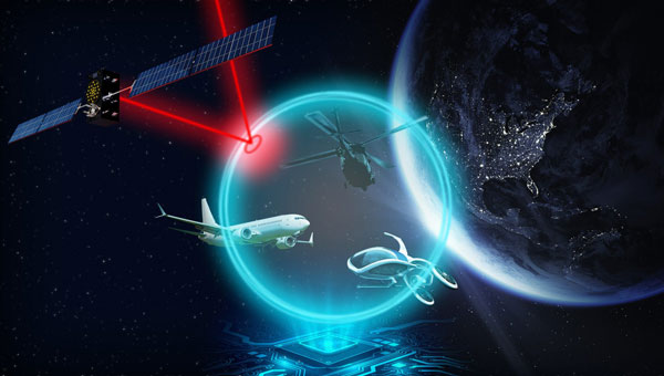
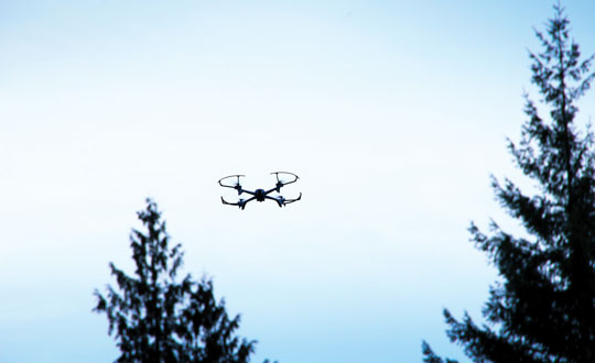
    Why was there a mix up in Tallahassee, Florida while trying to legislate for eVTOL air taxis and vertiports? Is China catching up on low-observable surveillance drones? And there’s news of an improved indoor UAV inspection system. This all appears to be happening in UAV-land this month.

    Not sure what’s cooking in my home State of Florida on approval of anticipated vertiports for use by eVTOL (electric Vertical Take-Off and Landing) and existing helicopter-type aircraft. Florida Department of Transportation (FDOT) published the findings of a state-formed aviation group in 2023 which appear to be pretty reasonable recommendations to ease approval of future vertiports – something seen as a major step forward for the introduction of eVTOL air-taxis in Florida. The Florida House passed Bill HB 981, which incorporated the FDOT findings and sent it to the Florida Senate for approval.

    Now, Senator Gayle Harrell has introduced an amendment to the bill for review by the Florida Senate, which seemingly adds unwanted restrictions. So, the Association for Uncrewed Vehicle Systems International (AUVSI) released an article criticizing the Senator’s proposed legislation as presenting additional hurdles for eVTOL introduction. AUVSI’s concerns with the Senate version focus on restrictive zoning language, which the Senator’s version has included as follows:

    “Ensure that a political subdivision of the state does not exercise its zoning and land use authority to grant or permit an exclusive right to one or more vertiport owners or operators and authorize a political subdivision to use its authority to promote reasonable access to advanced air mobility operators at public use vertiports within the jurisdiction of the subdivision.”

    In addition to the AUVSI article, an Advanced Air Mobility (AAM) coalition of key industry leaders — including AUVSI and BETA, Eve, Ferrovial, Joby, Lilium, Vertical, and Skyports Infrastructure — sent a letter with critical comments directly to Florida House leaders. AUVSI has been and continues to be supportive of Florida DOT’s AAM plan and recommendations, and has supported the House version of legislation.

    AUVSI believes Senator Harrell’s version would have created uncertainty and provided anti-AAM voices with a powerful tool to delay vertiport construction through drawn-out litigation. This language was widely viewed as problematic by both industry and lawmakers with whom AUVSI has collaborated during Florida’s state session.

    Fortunately, on March 7th the Florida House refused to concur with the Senate’s amendment. Now, however, the bill appears to be stalled and the Florida Legislature has packed up and gone on vacation for the summer.

    As things have progressed, we initially had the B2 ‘Spirit’ Strategic Stealth Bomber, a world first for the USAF and Northrup Grumman who built and fielded the secret, 172 ft wingspan, ‘radar-invisible’, tailless, long-range, defense-penetrating aircraft that has become a legend in its own right. Introduced in 1988, only 21 were produced.

    Then we had the 66ft wingspan RQ-170 ‘Wraith’ Stealth-UAV built by Lockheed Martin for USAF/CIA and introduced in 2007.  Used in a reconnaissance role, some have hinted that it may have replaced the U-2 spy plane in some roles – nevertheless, it’s a big drone that could imply long-range, high-altitude snooping.

    So now enters the Chinese ‘Sky Hawk’, a jet-powered, low-observable drone with only a 23 ft wingspan; which has an uncanny resemblance to both the B2 Spirit and more so the RQ-170 Wraith.

    We are told that the design of this UAV has recently undergone significant ‘enhancements’ and that flight testing of the variant has begun. Although smaller than the US RQ-170, the design is intended to enable ‘stealthy’ overflights of other territories. One of the recent additions is a V/UHF communications capability and the potential that brings for in-flight collaboration with fighter aircraft (aka US Loyal Wingman program) and autonomous operations once instructed.


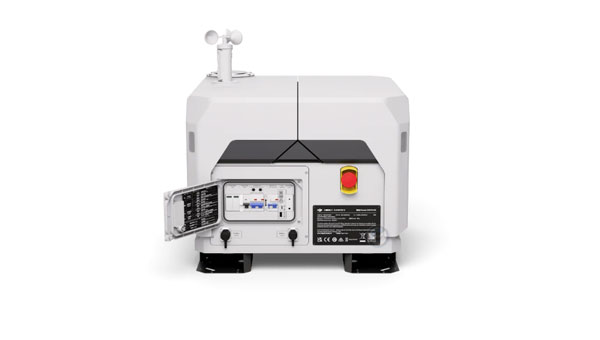
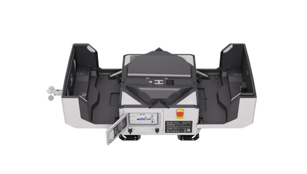
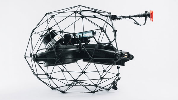
    Inspecting areas inside operational facilities can lead to major difficulties for first-hand physical access by maintenance/inspection personnel. Flyability in France has developed a drone that can operate inside a spherical cage encasing the whole vehicle, while still being able to receive radio commands and transmit video and data. Elios 3 is the latest product, which has been used in numerous successful inspection missions and has collected video to verify detailed machine and plant status.

    Now a critical area of verification which has been especially difficult to obtain has been added, which enables the measurement of object thickness using Ultrasonic sensing. The Ultrasonic Testing (UT) that the new probe makes possible allows thickness measurement of building walls, pipe walls, corrosion build-up, beams and a whole slew of previously unmeasurable, hidden features that may have gone without full inspection in the past.

    Customers of Flyability’s inspection drone in the oil, gas, chemical, and maritime industries have encouraged the addition of thickness measurement for some time, so Flyability hooked up with Cygnus Instruments to develop the UT measurement probe which has now been successfully ‘grafted’ into the Elios 3 drone.

    The Flyability drone can enter and explore closed/confined spaces that were previously dangerous and were perhaps almost impossible for people to physically inspect, so the addition of UT capability greatly enhances an already good thing!


    So, efforts by Florida to quickly adapt to the coming age of eVTOL, and to Vertiports which will allow people to gain access to air taxis, seems to have come into some sort of conflict with AUVSI – the very proponent for this mode of UAV transportation. We’ll have to see how this is resolved, as it surely will be.

    Technology catch-up by the Chinese developer of the Sky Hawk low-observability drone appears to be something to keep an eye on for a while. And meanwhile, new options for an autonomous indoor drone may be something the maintenance/inspection industry has been seeking for some time.

  • Saildrone launches first Surveyor USV for US Navy

    Saildrone launches first Surveyor USV for US Navy

    Image: Saildrone
    Image: Saildrone

    Saildrone has released its first aluminum Surveyor unmanned surface vehicle (USV) off the Austal USA production line in Mobile, Alabama. Chief of Naval Operations (CNO) Lisa Franchetti was on site to inspect the vehicle, ahead of these new USVs being tested under contract to the U.S. Navy.

    The Surveyor USV is primarily designed for ocean mapping and maritime domain awareness. The wind, solar power and a diesel generator for long-range, long-endurance missions in the open ocean power it.

    The Surveyor is equipped with the latest multibeam sonar technology, which enables it to map the seafloor up to a depth of 11,000 m. Additionally, it can carry defense and security payloads that are specifically designed to detect and respond to various maritime threats and challenges.

    Upcoming Navy missions will focus on the ability of the Surveyor to deliver both surface and undersea intelligence for a range of high-priority applications, including anti-submarine warfare (ASW).

    To meet the increasing demand for Surveyor USVs, Saildrone partnered with Austal USA, an Alabama-based ship manufacturer, to produce one Surveyor every six weeks, with the ability to scale up production as demand requires.

    At 20 m long and weighing 15 tons, the Surveyor classifies as a medium USV, built to American Bureau of Shipping (ABS) Light Warship code. These first Surveyors are contracted to the U.S. Navy to test and evaluate Surveyor-class vehicles in multiple environments.