Tag: autonomous vehicles

  • Use of autonomous vehicles in mining and farming touted at CES 2021

    Use of autonomous vehicles in mining and farming touted at CES 2021

    After years of testing and hype, not a lot of companies can say there are real applications for autonomous technology. However, at this year’s virtual CES 2021 trade show, both Caterpillar and John Deere, two companies known for their tractors and heavy equipment, showcased autonomous machines that are being used worldwide in farming and mining projects.

    Photo: Caterpillar
    Photo: Caterpillar

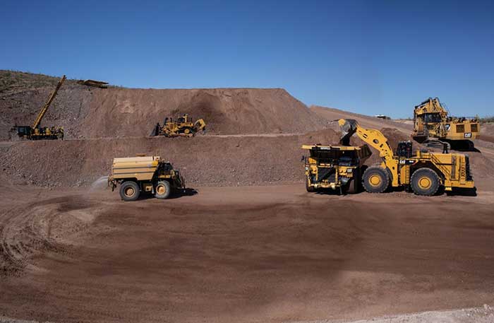
    Deerfield, Ill.-based Caterpillar, a first-time exhibitor at CES this year, said it has been involved in autonomy and use of GPS for more than two decades. “We were an early adopter of GPS when there were few satellites in the sky,” said Denise Johnson, company group president, resource industries. “We have 350 autonomous trucks operating 24-7 on three continents.”

    The company’s autonomous vehicles, in addition to other technology, are being used around the clock in the Kearl Oil Sands project in Alberta, Canada.

    “We are using autonomy primarily in mining operations in harsh environments. These [vehicles] are operating 24-7, with no loss time incidents,” said Bill Dears, Caterpillar worldwide sales and marketing manager. “We also track people underground with cameras and radar.”

    In addition to production enhancement, safety is a factor in mining operations because of operator fatigue — something that is precluded by autonomous mining equipment, Dears said.

    Agriculture uses variety of sensors, including GNSS

    To Moline, Ill.-based John Deere, exhibiting at the trade show for the third time, agriculture is a high-tech industry that uses GPS, self-driving tractors, artificial intelligence and a multitude of sensors. The company rolled out its first self-driving tractors nearly 20 years ago, said Jahmy Hindman, John Deere CTO.

    Photo: John Deere
    Photo: John Deere

    The company won the CES Innovation Award for one of its tractor and combine product lines. “Both our planter and tractor have GPS and antennas to know where to drive and where exactly fertilizer [is to be placed],” Hindman said. “These tractors are self-propelled, with accuracy augmented with [real-time kinematic] sub-inch accuracy for the planters in a field.”

    Among other requirements, Hindman said that tractors have to drive in a straight line, plant the required amount seeds and position them at the right depth. “When a tractor drives in a very straight line, the burden is off of the farmer. The yields increase—this is the way we see the progression of automation,” he said. “We are excited about 5G and its lower latency and high bandwidth. It opens up a lot of opportunity.”

    Organizers roll out Indy Autonomous Challenge race car

    At the virtual CES, representatives from the Indy Autonomous Challenge unveiled the Dallara IL-15 race car that will be used in a head-to-head race around the famous Indianapolis Motor Speedway on Oct. 23.

    The Indy Autonomous Challenge, organized by Energy Systems Network and Indianapolis Motor Speedway, pits 500 university students, developing autonomous vehicle technology, against each other for a $1.5 million prize.

    Logo: Indy Autonomous Challenge
    Logo: Indy Autonomous Challenge

    Organizers say the speeds are estimated to be as much as 200 mph around the 2.5-mile track, for 20 laps, which enables researchers to evaluate how autonomous vehicle technology works in extreme conditions. They say that the goal of the race is to advance the implementation of autonomous vehicles and advanced driver-assistance systems (ADAS), much like the 2005 Defense Advanced Research Projects Agency (DARPA) Grand Challenge.

    The race track has been the scene of much innovation throughout the years, said Doug Boles, Indianapolis Motor Speedway president. “Firestone tests tire technology there and that data transfers to our cars. One of the first conversations we had with Roger Penske [after Penske Entertainment bought the speedway] was about the autonomous challenge,” he said.

    IAC sponsors include ADLINK, Ansys, Aptiv, AutonomouStuff, Bridgestone, CU-ICAR, Dallara, Indiana Economic Development Corp., Microsoft, New Eagle, PWR, RTI, Schaeffler and Valvoline.

    Mobileye plans to test autonomous fleets in four cities

    Intel subsidiary Mobileye plans to launch autonomous vehicle fleet testing in Detroit, Paris, Shanghai and Toyko. The announcement, made at CES by CEO Amnon Shashua, said that the company also plans to test in New York City, pending regulatory approval.

    The company also plans to use in-house-built lidar sensors, while continuing to champion its camera-based testing. “We are using crowd-sourced data through the Cloud to build high-definition maps at scale,” Shashua said. “Thousands of product vehicles are sending us data.”

    Shashua addressed a moderator’s question that cameras alone cannot be the technology of choice for autonomous vehicles. “The camera first is crucial from a technology and business point of view. We have to find out what is acceptable failure for Level 4 autonomy. Camera-only is ideal, but pushing the envelope for driver-assistance systems,” he said. “Consumer AV will take place in the 2025 timeframe. [Eventually], we can build lidar and radar to the same performance levels as camera systems. Lidar and radar can be added later for redundancy, but only for Level 4.”

    Shashua said getting to Level 4 could take a decade, but that would be unsustainable unless there are government-funded projects to keep companies afloat. “By 2025, a subsystem will be good enough for consumers. Regulation is critical and sometimes it’s difficult to leap to a consumer level,” he said.

    Not everyone believes what Mobileye is testing constitutes “driverless” status. To Alain Kornhauser Princeton University professor and transportation program director, who was head of the university’s team during the 2005 DARPA Challenge, not many companies are capable of full driverless capability.

    “Unfortunately, I still see all of this as simply ‘eye candy’ to sell something that actually has no intention of delivering what it is implying. I still claim that the business case is zero, doesn’t exist, for personally-owned autonomous vehicles,” Kornhauser said in his Smart Driving Cars weekly newsletter. “Mobileye is nowhere close to being able to operate safely on most roads, let alone all roads. Thus, the consumer market has zero opportunity to scale.”

    Kornhauser said that driverless testing is being conducted only in one place, Phoenix, by Waymo. “Neither Tesla nor Mobileye are driverless anywhere. They both require on-board human driver supervision,” he said. “That’s why they are only self-driving [tests].”

    In other CES news:

    • GM CEO Mary Barra unveiled a single-seat electric vertical takeoff and landing (eVTOL) concept aircraft. The aircraft will be developed for future use as an air taxi. Barra briefly mentioned that the company’s Super Cruise self-driving technology will be integrated into 22 car models in a few years. The company also rolled out an electric vehicle for deliveries that can travel 250 miles on a charge and a motorized pallet for deliveries that can be tracked.
    • Photo: Mercedes-Benz
      Photo: Mercedes-Benz
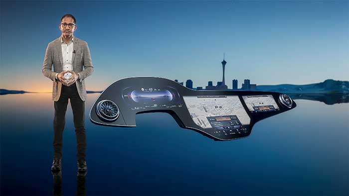
    • The Mercedes-Benz’ MBUX Hyperscreen, rolled out at CES, evaluates map data, surroundings and provides information about landmarks along a route, said Sajjad Khan, company CTO and member of the board of management. The new map feature, called Mercedes Travel Knowledge, allows a passenger or driver to ask a question as they drive by a landmark (“hey, Mercedes, what can you tell me about this building?”). The MBUX Hyperscreen is available in the new S-Class cars.
    • HERE Technologies introduced a mapping-as-a-service platform at CES. The platform is targeted to businesses wanting to create custom map datasets for advanced analytics and services, the company said. Some use cases include industrial yard mapping, leveraging probe data from private vehicle fleets in order to create or update a map.• A virtual CES is hard to get used to. After more than 20 years of covering the massive trade show in person, covering press conferences and conducting interviews online was sometimes a challenge. Sometimes the press conferences did not have question-and-answer sessions, or canned answers given to executives by public relations people. This doesn’t happen much during an in-person interview. In addition, trying to chat with “booth” personnel online was cumbersome and often those requests for information were ignored.
  • Verizon’s Skyward and UPS announce connected drone delivery at CES 2021

    Verizon’s Skyward and UPS announce connected drone delivery at CES 2021

    Skyward, a Verizon company, and UPS Flight Forward will collaborate to deliver retail products with drones connected to Verizon 4G LTE, as well as testing and integrating 5G for delivery.

    The companies made the announcement during the 2021 Consumer Electronics Show, taking place virtually.

    The companies aim to deliver retail products via connected drones at The Villages in Florida.


    The Villages is also the site of a driverless shuttle service test.


    “We will need the ability to manage and support multiple drones, flying simultaneously, dispatched from a centralized location, operating in a secure and safe environment,” said Carol B. Tomé, CEO of UPS. “To do this at scale, alongside Verizon and Skyward, we’ll need the power of 5G.”

    “We’re just beginning to see how the power of 5G Ultra Wideband will transform the way businesses operate,” said Rima Qureshi, chief strategy officer at Verizon. “By partnering with UPS and other innovative companies, we can learn from each other’s expertise and collaborate to create solutions that help move the world forward.”

    Photo: Verizon
    Photo: Verizon

    In 2020, Verizon, UPS Flight Forward and Skyward started testing 4G LTE in delivery drones to demonstrate cellular reliability and performance at altitude.

    “The low latency of 5G and edge compute is ideal for monitoring air traffic in and out of a busy logistics hub, especially those using mixed fleets of autonomous vehicles like drones, trucks and planes,” said Mariah Scott, Skyward President. “This year, we’ll be taking the collaboration with UPS further by testing 5G Ultra Wideband integrations to connect the sky.”

    UPS has operated more than 3,800 successful drone delivery flights since the creation of UPS Flight Forward, its drone delivery company, certified by the Federal Aviation Administration in 2019. But in 2020, drone delivery emerged as much more than rapid delivery of essential healthcare items — during the global pandemic it provided high-risk seniors a rapid and contactless delivery option to remain healthy at home.

    “Using Verizon’s 5G and Skyward, we’ll be able to transform the delivery experience — more personal, more on-demand and with the same safety, efficiency and reliability our customers trust today,” said Bala Ganesh, vice president, Advanced Technology Group at UPS.

  • SPH Engineering provides drone-integrated metal detection

    SPH Engineering provides drone-integrated metal detection

    Screenshot: UgSC
    Screenshot: UgSC

    SPH Engineering has launched a drone-integrated metal detection system with a Geonics EM61Lite metal detector, a new product of UgCS Industrial Solutions. The same performance and robustness available for users of the standard EM61-MK2 time domain metal detector are now available for airborne use.

    The new system is capable of detecting metallic (magnetic and non-magnetic) items in the first few meters under the surface, finding metallic objects in hard-to-reach or dangerous areas.

    Applications include unexploded ordnance (UXO) search, detection of underground infrastructure and archaeology. The integrated system has been extensively tested at SPH Engineering’s test range, and has shown excellent performance and repeatability for targets such as pipes (steel, stainless steel, reinforced concrete) and steel drums.

    The system uses an airborne (less heavy) modification of the Geonics EM61-MK2 ground metal detector. The EM61 Lite airborne variant integrates with the UgCS SkyHub onboard computer and ground control station.

    Features include automatic data logging in geotagged form and automatic terrain following with radar altimeter. The use of UgCS SkyHub enables the drone to fly in true terrain following (TTF) mode with the help of the radar altimeter and to log geotagged sensor data.

    An optional RTK/PPK GNSS receiver on the drone will geotag the data with centimeter-level precision.

  • Spanish elite units first to receive GMV Seeker drones

    Spanish elite units first to receive GMV Seeker drones

    Photo: Spanish Armed Forces/GMV
    Photo: Spanish Armed Forces/GMV

    The Spanish Army and Navy have received the first Seeker Remotely Piloted Aircraft Systems (RPAS) from GMV and Aurea Avionics. The unmanned aircraft is designed to boost the intelligence, surveillance and reconnaissance capabilities of two elite forces, the Spanish Army’s 6th Almogávares Paratroopers Brigade and the Marine Infantry Protection Force.

    Seeker has a 90-minute endurance and 15-km range, and weighs 3.5 kg. The UAV’s design and manufacture in Spain proved crucial during the COVID-19 epidemic, with the manufacture, test flights and delivery of the aircraft all performed within the project deadlines.

    In the final phase of the project, intensive training courses took place on the Madrid site of Aurea Avionics and the Los Alijares Firing and Maneuvering Range (CMT) of Toledo. There, future Seeker users put the RPAS through its paces with mission simulations, engaged in vehicle-tracking exercises and learned about  its theoretical and practical uses.

    Seeker will provide BRIPAC (Paratrooper Brigade) and BRIMAR (Marine Infantry Brigade) with real-time thermal-infrared and visible-spectrum video, augmented by metadata that can be mined by the operators and remotely by the command-and-control centers.

    New digitized ground-station architecture makes Seeker compatible with NATO’s standard command centers. This means any allied force will be able to integrate the aircraft into its fleet and command centers, ensuring joint operability between all troops and systems.

    The RPAS is financed by the Subdirectorate General of Planning, Technology and Innovation of the Directorate General of Armaments and Material.

  • The drive to autonomy: Companies gear up with sensors, strategies

    The drive to autonomy: Companies gear up with sensors, strategies

    For the past decade, widespread deployment of autonomous vehicles (AV) has been just over the horizon — that imaginary line that recedes as you approach it.

    It has been delayed mainly by technical issues, which will eventually be followed by legal and regulatory ones, mainly regarding liability, and by a struggle to gain public acceptance. When they finally reach the mass market, however, AVs will reduce traffic fatalities by at least an order of magnitude because they do not get distracted, drunk, drowsy or enraged and are much better able than humans to gauge distances and speeds.

    Image: IGphotography/iStock/Getty Images Plus
    Image: IGphotography/iStock/Getty Images Plus/Getty Images

    Additionally, they will be able to communicate with each other and with the infrastructure, which will not only further improve safety but also reduce congestion and fuel consumption via the adoption of techniques such as convoying.

    Logically, even if AVs only somewhat reduced traffic fatalities (about 38,000 per year in the United States), the public should welcome them with open arms. In reality, though, the reaction to even a single death caused by an AV — like the one in Tempe, Arizona, in March 2018 — can set AV deployment back years.

    Therefore, car manufacturers are challenged to develop AVs that can navigate extremely safely in a wide range of traffic, road and weather conditions. For more than a century, human drivers have routinely managed sudden obstructions, poor visibility and dangerous behavior by other drivers that still bedevil their new robotic counterparts, despite the sensors, microprocessors and algorithms at their disposal.

    The primary technological obstacle to widespread deployment of AVs on roads is “the complexity of the system and the amount of time that it takes to develop a functionally safe autonomous vehicle,” said Steve Ruff, general manager of Trimble’s On-Road Autonomy Division, which develops positioning solutions for autonomous vehicles that operate on public roadways. He cites the time required to develop “a comprehensive, safe, autonomous vehicle technology stack” and points out that “we are on the verge of going from level two to level three, which requires the driver to stay engaged in the driving experience in case the autonomous system has a problem.”

    Multiple sensors

    While AV developers are exploring different ways of obtaining reliable sub-centimeter positioning accuracy, all generally rely on collecting data from multiple sensors on the vehicle and applying an algorithm to synthesize the data in real time and generate a continuous, accurate position. Computer vision, radar and lidar play important roles in an AV by perceiving its surroundings and localizing it to an a priori map. This functions well in feature-rich urban environments, but can degrade in sparse highway settings.

    Radar has good ranging accuracy, but is unable to detect and recognize traffic signs and road markings. Lidar has even greater ranging accuracy but is challenged in featureless areas, such as straight highways and country roads. Digital cameras are good for detecting objects and navigating in tunnels and urban canyons, but, like lidar, are less effective on featureless roads and in low visibility conditions (rain, fog, darkness, snow, sun glare).

    Plus, they are challenged by the absence of road markings or the presence of construction. Inertial navigation systems (INS), while excellent at compensating for brief GNSS outages, can only guide vehicles for short stretches due to their inherent drift. (INS are essential on aircraft and vessels, whose attitude is constantly changing, but that is not relevant for vehicles, which travel essentially flat relative to, and at a constant distance from, the road surface.)

    GNSS and Corrections

    Satellite navigation plays a central role in an AV. At a minimum, it guides it from a trip’s origin to its destination, including stops or waypoints in between, the same way it would advise a human driver. It also continuously alerts the vehicle to upcoming stops, slowdowns, turns, congestion and other challenges that are already mapped—whether long in advance by map makers or moments earlier via crowdsourced updates. Finally, if sufficiently accurate, it can steer the vehicle to keep it in the center of its lane and to make smooth lane changes and turns. Determining on which road a vehicle is requires an accuracy of less than 5 meters; determining in which lane it is requires an accuracy of less than 1 meter; and determining where in the lane it is requires an accuracy of less than 0.5 meters.

    Two kinds of GNSS corrections are commonly used for AVs: real-time kinematic (RTK) and precise point positioning (PPP). RTK, which is generally accurate to the centimeter level, relies on ground-based reference stations at fixed, surveyed locations that process and transmit error-corrected signals to receivers within a 10- to 20-kilometer range, typically in real-time via a cellular link. PPP, which is accurate to the tens of centimeters, uses a global network of ground stations to generate an accurate signal, and transmits it to subscribers via the internet or geostationary satellites. However, the receiver in the vehicle needs 20 to 60 minutes to align with the PPP signal before it can rely on it.

    Both RTK and PPP are established in industries such as mining, construction and precision agriculture, where vehicles operate in controlled environments with little or no traffic. AVs on public roads present a far greater challenge. A car’s typical range far exceeds that of any RTK base station, and base stations can also have down time, while in-vehicle systems must use multi-frequency receivers to reduce the convergence time of the PPP signal. In case of outage of either the GNSS signal or the correction signal, the vehicle’s system must rely on data from its other sensors and recover swiftly from the error state.


    Trimble’s RTX is road ready

    The first PPP service in commercial use for passenger vehicles is Trimble’s RTX, which provides real-time, centimeter-level positions via IP/cellular connection or satellite broadcast worldwide. It delivers positioning via satellite to GM’s Super Cruise, a hands-free driver assistance feature for use on limited access freeways.

    “We’re GNSS receiver-agnostic,” said Steve Ruff of Trimble’s On-Road Autonomy Division. “We’ll use any receiver that’s preferred by the OEM building the AV.”

    Image: Trimble
    Image: Trimble

    Trimble, he recalled, became GNSS agnostic with regard to automotive navigation nearly 15 years ago, when it decided to get out of the commercial-grade or consumer-grade GNSS business. “It has worked out quite well, because not only can we meet the quality costs and performance targets of our OEM customers, it also allows us to do what we’re good at. We can take our positioning solution, adapt it to work with any measurement engine, and put together a solution that fits the OEM’s requirements just right.”

    Automotive companies, Ruff explained, generally have certain requirements for the GNSS receiver, including certain standards for application-specific integrated circuits (ASIC) and automotive safety integrity level (ASIL), as well as meeting their accuracy requirements. “So, if the receiver has suitable code and carrier phase measurements that can support their accuracy level, then that will be the third requirement for the receiver for the automotive segment.”

    For off-road vehicles for agriculture, construction and mining, Trimble only uses its own receivers, said Thomas Utzmeier, general manager of the company’s Off-Road Autonomy Division. Their requirements center on precision, position availability in challenging environments, and integrity of the position. “In the use cases on which we are working,” Utzmeier said, “we certainly see sub-decimeter accuracy. We are targeting probably three, four, sometimes five centimeters.” In more challenging use cases, GNSS plus sensor fusion — including INS and optical data — maximizes position availability and accuracy, he explained.

    For the on-road segment, Ruff’s division offers a “positioning stack” that includes corrections, the GNSS position algorithm and inertial fusion. “Then we provide services to help the OEMs take our software and integrate it on the platform of their choice.”

  • Emlid launches Reach RS2 multi-band RTK receiver

    Emlid launches Reach RS2 multi-band RTK receiver

    Photo: Emlid
    Photo: Emlid

    Emlid has debuted the Reach RS2, a fully-featured multi-band RTK receiver. All of its features are available out of the box, along with a survey app for iOS and Android.

    The Reach RS2 tracks L1/L2 bands on GPS, GLONASS and BeiDou, and L1/L5 on Galileo, and acquires a fixed solution in seconds. It achieves centimeter-level precision for surveying, mapping and navigation and maintains robust performance even in challenging conditions. Centimeter accuracy can be achieved on distances up to 60 km in RTK and 100 km in PPK mode.

    Up to 22 hours of autonomous work when logging data and up to 16 hours as a 3G rover, even in cold weather—no more need to carry spare batteries with you. Reach RS2 can charge from a USB wall charger or a power bank over USB-C.

    Reach RS2 comes with a free app for iOS and Android called ReachView, which supports thousands of coordinate systems worldwide. With ReachView, users can fully configure their Reach receiver, enable RINEX data logging, and survey in RTK.

    Reach RS2 also features a power-efficient 3.5G HSPA modem with 2G fallback and global coverage. Corrections can be accessed or broadcast over NTRIP independently, without relying on an internet connection on a smartphone.

    Base for RTK Drone. The Reach RS2 can be used as a base station for drone mapping, using an RTK drone such as the DJI Phantom 4.

    A new service offered by Emlid is Emlid Caster, a free way to pass corrections between receivers over the internet. Emlid Caster works with any NTRIP-capable device.

    E38 Survey Solutions, an Emlid dealer in the United States, conducted a case study with the Reach RS2.

  • UAV updates: Overcoming a navigation challenge, autonomous UAS rolls out

    UAV updates: Overcoming a navigation challenge, autonomous UAS rolls out

    The Boeing B-777 or “Triple-7” is a big airplane — at over 200 feet long, with a wingspan of more than 200 feet, it carries more than 300 people. But getting it from one airport to its destination, which could be up to 8,500 nautical miles away, presents a significant navigation challenge. Combined Air Data and Inertial Reference Unit(s) (ADIRU) and three GPS L1 receivers form the certified primary navigation sensor cluster for the B-777-200.

    Boeing has been undertaking its ecoDemonstraor program using various models of its aircraft, and in 2019 a B-777-200 was available for a number of technology demonstrations.

    Along with the basic objective of testing out new fuel efficient technologies, Collins Aerospace collaborated with Boeing to demo and test their new generation navigation system using dual frequency, multi-constellation GNSS receivers.

    Boeing B-777-200 ecoDemonstrator (Photo: Boeing)
    Boeing B-777-200 ecoDemonstrator (Photo: Boeing)

    The aircraft is normally equipped with buyer selected, certified GPS receivers which also track world-wide Satellite Based Augmentation System (SBAS) signals — not only improving accuracy but also improving (or reducing) the size of integrity bounds of the position solution. Currently, GPS/SBAS L1 is the only signal permitted under current FAA approved MOPS (Minimum Operational Performance Standards) for aircraft use in the US, but new MOPS standards are under development for the use of DFMC. Hence, this demonstration program would significantly aid towards validation of the new MOPS standards.

    For the demo program, the Collins Aerospace GLU-2100 Dual-Frequency Multi-Constellation (DFMC) enabled multi-mode receiver (MMR) was used as the primary position source. The three GLU-2100 MMRs fitted were loaded with modified software that enabled the tracking and use of GPS L1/L5 and Galileo E1/E5a for the navigation solution using multi-frequency GNSS antennas.

    The navigation mode and position integrity algorithms were also revised so the DFMC navigation outputs could be used as the primary navigation outputs for the Flight Management System and the transponder. The Collins GLU-2100 certified L1 position solution was computed in parallel and used to bound the integrity of the Collins DFMC position solution.

    The demo gathered stacks of data on this first use of a DFMC receiver as the primary position source on a civil air transport aircraft. The lessons learned will undoubtable support the effort towards the introduction of dual frequency multi constellation GNSS for regular use in civil aviation.

    Meanwhile, in the world of unmanned aircraft, several thing of note were recently reported, including:

    • Aveum Inc. rolled out its Ravn-X autonomous UAS, which is claimed to be a large, fully autonomous unmanned vehicle which can deliver satellites to low earth orbit.
    • General Atomics demonstrated its Avenger UAV with autonomous CODE (Collaborative Operations in Denied Environment) capability and completed static load testing of the MQ-9B SkyGuardian wing, part of the regular qualification program for civilian aircraft certification.
    • Airbus Zephyr High Altitude Platform Station (HAPS) UAV completed another phase of high-altitude flight testing in Arizona.

    The Ravn-X is a large UAV which apparently uses regular jet fuel, yet claims to be able to get to low-orbital altitudes. With a 60-foot wingspan, 80-f00t length and up to 55,000-pound take-off weight, this is certainly a large vehicle.

    There looks to be a long tubular belly protrusion which could be a rocket motor, or fuel tank, or even a payload bay — absent any explanation of how regular air-breathing engines could reach space, we’ll have to speculate — maybe a new type of engine? Nevertheless, burning jet fuel alone, gaining space access might be difficult. Apparently the US Space Force is a sponsor and future customer, so there should be credibility to these claims.

    Ravn-X new-gen space UAV (Photo: Aveum release)
    Ravn-X new-gen space UAV (Photo: Aveum)
    X-37B U.S. Spaceplane (Photo: U.S. Air Force)
    X-37B U.S. Spaceplane (Photo: U.S. Air Force)

    The object is to provide rapid access to space for small payloads with a reusable, autonomous, unmanned vehicle. The current vehicle is apparently 60% re-usable, soon to become up to 95%. And minimizing turn-round time is also a major target, with a claim of 3 hours being possible — quite an achievement. Of course, the U.S. already has the X-37B Orbital Test Vehicle spaceplane in operation, with a record 780 day stay in space already under its belt.

    During the recent two-hour test flight of the General Atomics Aeronautical Systems Inc. (GA-ASI) Avenger UAV, equipped with tactical radio/data links and targeting capability, independence between control and mission systems was demonstrated.

    The flight also tested a degree of autonomy related to the U.S. Air Force Skyborg (aircraft-UAV teaming) program. The USAF Collaborative Operations in Denied Environment (CODE) software controlled the flight for over two hours without regular ground operator inputs, and coordinated air-to-air search operations with one actual and 5 simulated aircraft.

    GA-ASI Avenger UAS (Photo: GA-ASI)
    GA-ASI Avenger UAS (Photo: GA-ASI)

    The Airbus Zephyr High Altitude Platform Station (HAPS) successfully completed another series of flight tests in Arizona in the first weeks of November. The UAV has undergone weight reductions and was equipped with revised control software which improved system robustness. The UAV is powered solely by sunlight, operates in the stratosphere and provides persistent services currently provided by satellite.

    Zephyr is prepared for flight-test (Photo: Airbus)
    Zephyr is prepared for flight-test (Photo: Airbus)

    Operational flexibility and aircraft maneuverability were demonstrated, particularly during lower altitude flying and during transition into the stratosphere. A new flight planning tool suite was put through its paces and a number of different operational concepts were tested by conducting many flights in quick succession.

    These tests again demonstrated Zephyr’s capability for take-off, climb, cruise, the performance of the upgraded flight control system, descent and successful landing. Day and night on-station performance of almost 26 days was previously demonstrated during July 2018 flight tests.

    It’s good to see demonstrated progress towards dual frequency GPS/Galileo civil aircraft operations through the Boeing ecoDemonstrator program, along with UAV initiatives in potential space-launch capability, autonomous aircraft-UAV teaming, and advances in the HAPS concept. All this, even with the work managed despite these interminable COVID-19 restrictions.

  • UAVOS releases Xservo-Series Actuators

    UAVOS releases Xservo-Series Actuators

    Image: UAVOS
    Image: UAVOS

    UAVOS has debuted its Xservo-Series Hollow Shaft Servo Actuators, which feature embedded CANopen/EtherCAT servo drive.

    The actuators include a built-in motion controller, which allows users to skip the complex stage of mechanical and electrical integration of a passive servo actuator with an external servo drive controller, the company said.

    In addition, the actuators, which are encased with rugged, IP65-rated anodized aluminum alloy casing, boast a hollow shaft that makes it easy to pass power supply cables, shafts or laser beams directly through the servo actuator.

    According to UAVOS, the actuators are capable of nx360 degree proportional rotation and are ideal for a wide range of rotary applications within UAVs and robotic platforms. New actuators are immune to shock and vibration and designed for use in harsh conditions, the company added.

    “This is just the beginning of a series of product releases we are planning for this year, and our customers can be excited about what is about to come,” said Aliaksei Stratsilatau, CEO and lead developer at UAVOS. “Our incentive is to meet most of our customers’ requirements, and this is why we constantly invest in our R&D capacities and keep an ear close to the market.”

    UAVOS Xservo-Series are designed to be used in industrial applications where high accuracy, high torque and low weight are essential.

  • SimActive integrates software in lidar solution for drones

    SimActive integrates software in lidar solution for drones

    Image: SimActive
    Image: SimActive

    SimActive Inc., a developer of photogrammetry software, has integrated its Correlator3D product into lidar systems for drones developed by Lidar USA.

    Possible configurations include two side-by-side cameras that allow matching the footprint of the lidar sensor, a particularly useful setup for corridor mapping.

    SimActive’s Correlator3D software is used for automatically registering the imagery with the lidar data. Once a perfect alignment has been achieved, the point clouds are colorized using the photos.

    “The ability to directly use lidar as control for adjusting image positions really is a unique feature,” said Jeff Fagerman, CEO at Lidar USA. “Correlator3D allows our clients to quickly combine lidar with data from multi-camera systems and produce high-quality outputs.”

    Correlator3D software is a patented end-to-end photogrammetry solution for the generation of high-quality geospatial data from satellite and aerial imagery, including drones. Correlator3D performs aerial triangulation and produces dense digital surface models, digital terrain models, point clouds, orthomosaics, 3D models and vectorized 3D features.

    Powered by GPU technology and multi-core CPUs, Correlator3D’s processing speed supports rapid production of large datasets.

    Lidar USA, also known as Fagerman Technologies, is a family owned business just outside of Huntsville, Alabama. Lidar USA specializes in laser scanning, photogrammetry, instrumentation and all things geomatics.

  • U-blox signs deal with UK start-up for cutting-edge GNSS technology

    U-blox signs deal with UK start-up for cutting-edge GNSS technology

    Map plot from live tests in London show the route of a vehicle driven through Canary Wharf. It shows the difference between the position provided by a standard smartphone GNSS chip (red line) and the same data run through Focal Point Positioning's Supercorrelation software (blue line). (image: u-blox)
    Map plot from live tests in London show the route of a vehicle driven through Canary Wharf. It shows the difference between the position provided by a standard smartphone GNSS chip (red line) and the same data run through Focal Point Positioning’s Supercorrelation software (blue line). (Image: u-blox)

    U-blox has signed a deal with the award-winning U.K.-based technology company Focal Point Positioning to integrate technology that will improve the accuracy and reliability of GNSS devices. Focal Point’s Supercorrelation technology enhances positioning performance and security for applications such as smart cities, location-secure internet of things (IoT) and health and fitness wearables.

    The patented Supercorrelation technology solves a critical weakness in GNSS caused by multipath interference. Multipath interference occurs when satellite signals bounce off buildings and landmarks, causing GNSS receivers to provide degraded positioning outputs.

    The result for users is that the blue dot on their phone or device may be in the wrong place, moving in the wrong direction, or may have a large error ellipse. For autonomous vehicles it could lead to positioning errors that place the vehicle in the wrong lane or worse.

    FocalPoint’s Supercorrelation technology uses software to detect and reject reflected signals, resulting in an improvement in the performance of GNSS devices without the need for additional hardware or applications. Supercorrelation also helps with the detection and rejection of GNSS spoofing signals — an increasing concern for autonomous vehicles, ships, and aviation.

    “We are tremendously excited to be working alongside a market leader such as u-blox, our mission is to improve every positioning system on the planet and we have taken a giant step forward in that vision with this deal,” said Focal Point Positioning CEO Ramsey Faragher. “Positioning systems are so critical to our world, and we look forward to seeing the next generation of products and services that will be enabled by this higher level of accuracy, reliability and security.”

    u-blox CEO Thomas Seiler commented, “The addition of Supercorrelation technology into our latest GNSS platforms is part of our continuing focus on low power consumption, higher accuracy and security for automotive, industrial, and wearable GNSS applications.”

  • FLIR Systems acquires Altavian for defense sUAS

    FLIR Systems acquires Altavian for defense sUAS

    Photo: FLIR Systems
    Photo: FLIR Systems

    FLIR Systems Inc. has acquired Altavian Inc., a privately held manufacturer of small unmanned aerial systems (sUAS) for defense and public-safety customers.

    Altavian’s airframes integrate multiple sensors, including FLIR thermal technology, to provide users with decision support and intelligence, surveillance and reconnaissance (ISR) capability.

    Based in Gainesville, Florida and founded in 2011, Altavian designs and manufacturers Group 1 UAS solutions for long or short range operations. With both quadcopter and fixed-wing UAS designs, Altavian’s expertise includes aeronautics, avionics, and software, and its solutions are engineered around an open system architecture aligned to the needs of government and defense customers.

    Altavian is one of five drone manufacturers approved by the U.S. Department of Defense under the Blue sUAS program to sell to the U.S. military and federal agencies.

    “Altavian’s proven engineering expertise and assets will allow us to offer customers the most comprehensive solution portfolio of any American sUAS provider,” said Roger Wells, general manager of the Unmanned Systems and Integrated Solutions business of FLIR Systems’ Defense Technologies Segment, under which Altavian will be integrated. “With the addition of both a low-cost, rapidly deployable quadcopter and a longer range fixed-wing UAS, FLIR is strengthening its already impressive drone lineup, including our Black Hornet and SkyRaider platforms used extensively by militaries around the globe. We’re excited about the multiple new franchise opportunities FLIR will be able to pursue for defense, public safety, and industrial markets worldwide.”

    For more information about FLIR Systems’ existing sUAS solutions, visit flir.com/defense-uas.

  • Trimble RTX corrections now transmitted through Sirius XM

    Trimble RTX corrections now transmitted through Sirius XM

    Photo: Photo: Blue Planet Studio/iStock/Getty Images Plus/Getty Images
    Photo: Blue Planet Studio/iStock/Getty Images Plus/Getty Images

    Trimble RTX GNSS corrections are now being transmitted through the SiriusXM satellite radio network, specifically through Sirius XM Connected Vehicles Services.

    As a result, new cars sold in the contiguous U.S. and Canada equipped with SiriusXM’s Gen8 satellite chipset will be able to receive RTX GNSS corrections, enabling high-accuracy positioning — a key component of autonomous on-road applications.

    With the addition of the Trimble RTX Auto software library, any new vehicle that receives SiriusXM broadcasts with a Gen8 satellite chipset can leverage a positioning solution ideal for advanced driving assistance systems (ADAS), autonomous driving (AD) and vehicle-to-everything (V2X) applications.

    Because the SiriusXM hardware is already installed in most new vehicles, automotive OEMs can avoid the cost of additional hardware to receive GNSS positioning corrections.

    “We are excited to add Trimble RTX Corrections to our suite of Connected Vehicle services,” said John Jasper, senior vice president for SiriusXM Connected Vehicle Services. “By delivering this service over our satellite broadcast network, automakers can access relevant location correction data throughout the contiguous U.S. and portions of Canada to facilitate ADAS, AD and V2X applications without the need to access a cellular network.”

    Trimble RTX is a trusted precise-positioning technology of choice for car manufacturers and their suppliers, and was the first solution adopted for production use in passenger vehicles. RTX technology is a critical component of General Motors’ Super Cruise™ system—the first hands-free driving assistance system for the highway. To date, Super Cruise and Trimble RTX have enabled over 5 million miles of hands-free driving on America’s roadways.

    Designed for automotive applications, the RTX Auto software library is Automotive Safety Integrity Level B (ASIL-B) certified and developed using the Automotive SPICE process maturity framework (Software Process Improvement and Capability Determination – ISO 15504). The RTX network operation is certified according to ISO 20000 standards, providing further peace of mind for any industry deploying safety-critical applications. No other precise positioning solution offers the same level of performance, reliability, versatility and coverage worldwide.

    Trimble RTX technology provides real-time, multi-constellation correction of GNSS observations to provide significantly more precise position estimates. Standard GPS signals can drift up to 25 feet, which could cause incorrect lane identification. When used in conjunction with high-definition maps, cameras, radar and inertial sensors, Trimble RTX provides lane-level positioning performance for semi-autonomous and autonomous vehicles.

    “The alliance with SiriusXM provides an expansive distribution pipeline for Trimble RTX into new passenger vehicles,” said Patricia Boothe, senior vice president of Trimble’s Autonomy Sector. “OEMs now have an easy, cost-efficient alternative to bring high-precision GNSS into their vehicles. Together, Trimble and SiriusXM are helping to accelerate the adoption of real-time positioning in connected vehicles, ultimately supporting safety-critical V2X applications.”