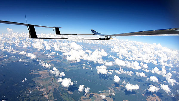
UAVOS Inc. has performed a series of successful flight trials with High Altitude Pseudo Satellite (HAPS) ApusDuo, testing its unique control system.
The test flights confirmed that UAVOS’s control system allows aircraft with a large-wing elongation to fly in unstable atmospheric conditions. The ApusDuo aircraft successfully copes with turbulence, actively changing the bend of the wings.
The total flight time of UAVOS solar-powered test aircraft is more than 1,000 hours. Test flights took place at an altitude of up to 62,000 feet (19,000 meters).
UAVOS’s control system does not require the installation of wing mechanization. This reduces the aircraft’s weight by 30% or more, improves reliability and simplifies wing production for lower manufacturing costs.
The ApusDuo drone weighs about 95 lbs (43 kg) and has a wingspan of 49.2 ft. It is launched by a winch. The aircraft is built on the tandem principle, where two of the wings are located one after another with a small elevation difference.
ApusDuo is controlled by changing the geometry of the aircraft. It is designed to linger at an altitude of about 60,000 feet (18,000 m) for months at a time for surveillance or to provide a temporary boost to communications.
Additional test flights are planned for this year, said Aliaksei Stratsilatau, UAVOS CEO and lead developer.
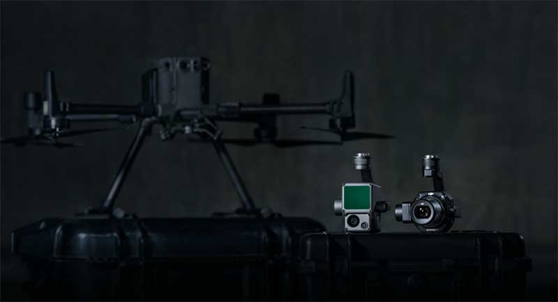
DJI unveiled two new solutions at Intergeo 2020: the DJI Zenmuse L1 lidar solution for aerial surveying and DJI Zenmuse P1 camera payload. (Photo: DJI)
DJI has debuted two payload solutions for its flagship commercial drone platform Matrice 300 RTK: the DJI Zenmuse L1 and DJI Zenmuse P1. The solutions were unveiled at Intergeo 2020.
DJI Zenmuse L1
The Zenmuse L1 is DJI’s first lidar solution for aerial surveying. DJI Zenmuse P1 integrates a Livox lidar module with a 70-degree FOV, a high-accuracy IMU, and a 20-megapixel camera with a 1-inch CMOS sensor and a mechanical shutter on a 3-axis stabilized gimbal.
According to DJI, the Zenmuse L1, which has a point rate of 240.000 points per second and a detection range of 450 meters, can generate true-color point cloud models in real-time, or acquire a vast area (up to 2 km2) of point cloud data in a single flight. The module supports both line scan mode and non-repetitive scanning mode.
When used with DJI’s flagship commercial drone platform Matrice 300 RTK and DJI Terra surveying software, it becomes a complete and versatile solution that gives the user real-time 3D data throughout the day, efficiently capturing the details of complex structures and delivering highly accurate reconstructed models, DJI said.
DJI Zenmuse P1
The DJI Zenmuse P1 camera payload integrates a 45-megapixel full-frame low-noise high-sensitivity sensor offering flexible viewing with interchangeable 24/35/50mm fixed-focus lenses on a 3-axis stabilized gimbal.
According to DJI, the Zenmuse P1 is equipped with a TimeSync 2.0 system, which synchronizes time across modules at the microsecond level. It features a smart oblique camera feature that helps improve efficiency by only capturing the photos essential to the reconstruction at the edge of the mapping areas. DJI Zenmuse P1 also integrates a 45-megapixel full-frame low-noise high-sensitivity sensor.
“With these two new payloads, we are providing an all-integrated complete solution to our enterprise customers active in accurate geospatial data acquisition,” said Arjun Menon, engineering manager at DJI in the U.S. “Having a fully integrated capable and affordable lidar seamlessly integrated into our best commercial drone is a dream that becomes reality for surveying, mapping and construction professionals. They will be able to see, cover and understand the geospatial context from a totally new perspective thanks to the high level of accuracy and quality of the data collected from these tools in the sky.”
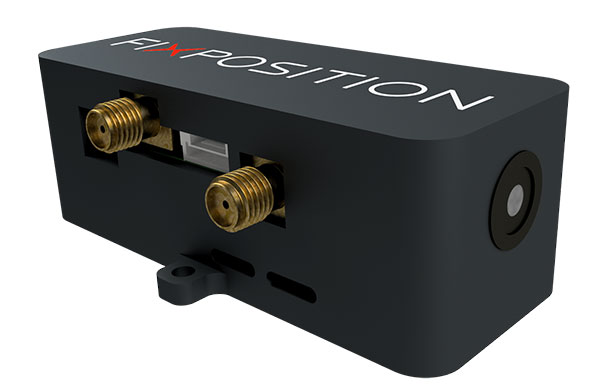
Vision-RTK enables applications in previously unreachable areas and unlocks new possibilities for autonomous ground robots and drones
At this year’s Intergeo Digital event, taking place Oct. 13-15, Fixposition is debuting the Vision-RTK positioning sensor, a compact centimeter-accurate solution with high reliability and availability in environments that are challenging for traditional GNSS.
Photo: FixPosition
The Vision-RTK’s sensor-fusion algorithm is based on the deep integration of satellite, camera and inertial sensors, and enables unprecedented reliability and availability in diverse and challenging applications, the company stated.
“The highly integrated nature of our Vision-RTK sensor and our deep expertise in computer vision and real-time kinematic (RTK) GNSS enabled us to implement completely new approaches in sensor fusion, resulting in previously unseen performance,” said Lukas Meier, CTO and co-founder of Fixposition.
Traditional GNSS sensors suffer from limited reliability in GNSS-challenging and denied areas. On the other hand, standalone computer vision is sensitive to light conditions (such as snow, strong sunlight and rain) and struggles in situations where there is a lack of features such as cornfields and grass. Errors accumulate over time with standalone inertial technology, causing large drifts.
As a result, devices using either sensor are limited in their range of operation and are likely to fail in certain conditions. Fixposition’s solution increases the potential of these sensors with its unique sensor-fusion technology by increasing the trustworthiness of the positioning accuracy and the range of operation in different environments.
The real-time sensor fusion provides centimeter-accurate absolute positioning at any time, in any outdoor environment. This small module integrates two RTK-GNSS receivers and visual inertial navigation, and is suitable for applications where size and accuracy are of paramount importance.
The dual-receiver configuration, together with Fixposition’s advanced algorithms, provides a true-heading output and increased resistance to electromagnetic radiation.
The sensor provides USB and Wi-Fi connectivity and a web interface. It enables straightforward integration in state-of-the-art autopilot control systems for drones and robots. It’s also plug-and-play compatible with platforms such as PX4, ROS and Apollo.
For ground robotics and drones applications, Vision-RTK increases the device uptime and efficiency while enabling new market segments in areas previously inaccessible. For end-device manufacturers, this technology eliminates the need for an in-house development of advanced localization solutions, shortening their sales cycle and reducing costs and investments.
Visit the Fixposition booth and meet the team at Intergeo Digital 2020 to learn more about the Vision-RTK sensor.
I spent much of the 1980s working for Magnavox Government & Industrial Electronics Company, which held a number of patents on the GPS system and also developed prototype GPS user sets for the military. I, and others at the company, often gave presentations to industry groups talking about the many commercial and consumer applications for which GPS would be used as the cost and size of GPS receivers declined. By the early 2000s, the applications we had envisioned had been far surpassed.
In the early 1990s, I spent several years at Teletrac, now Teletrac Navman, which was beginning to market a vehicle tracking solution based on its own proprietary time-difference-of-arrival (TDOA) technology, using in-vehicle devices and metro-area-based receiving/transmitting towers. One day, the co-founder and chairman of the company roamed into my office for an update on sales and marketing progress. I changed the subject and, at some risk to my job, said “Dennis, the future of location technology is GPS. It will not just be used to locate vehicles, but even cellular phones. With teams of talented engineers focused on reducing the size and cost of receivers and adapting them to specific applications, ‘the sky is the limit’.” He didn’t fire me, but spent the rest of our discussion telling me why I was wrong — that GPS receivers would always be too large, too expensive, too susceptible to signal blockage, and other limitations.
Thirty years later, the applications I had envisioned for GPS have been greatly surpassed and are constantly expanding. In recent years, my primary focus has been on researching the growth and trends of the commercial telematics market in the U.S. and abroad. Today, in the U.S. alone, some 16 million GPS devices are being used to monitor fleet vehicles and assets, such as trailers and heavy construction equipment. Even in the face of the COVID-19 pandemic, the market remains stable and is on track to grow for the year.
In the future, GPS will play an essential role in the deployment of autonomous vehicles, with help from other technologies needed to optimize location accuracy and reliability. My hat is off to the founding fathers of GPS who include some of the most brilliant technologists of this era.
Walmart is teaming up with drone delivery company Zipline to launch a drone delivery operation in the United States. According to Walmart, this first-of-its-kind drone delivery service will make on-demand deliveries of select health and wellness products with the potential to expand to general merchandise.
Trial deliveries will take place near Walmart’s headquarters in Northwest Arkansas. The trials will use Zipline’s proprietary technology.
Zipline will operate from a Walmart store and can service a 50-mile radius, Walmart said. The company’s launch-and-release system allows for quick on-demand deliveries in under an hour, and it also eliminates carbon emissions, Walmart added.
Zipline began operating in 2016 in Rwanda, primarily focusing on the on-demand delivery of medical supplies. According to Zipline, it has safely delivered more than 200,000 critical medical products to thousands of health facilities serving more than 20 million people across multiple countries.
The operation will likely begin in early 2021, Walmart said.
The U.S. Federal Aviation Administration (FAA) has made it easier for drone pilots to quickly and safely access controlled airspace by adding 133 air traffic facilities to the Low Altitude Authorization and Notification Capability (LAANC) system. The expansion is based on feedback from the drone community.
LAANC is an automated application and approval system for drone pilots requesting to fly below 400 feet in controlled airspace.
As the FAA continues to modernize the national airspace to accommodate more users, the agency made LAANC accessible for 726 airports and 537 facilities, covering 81% of eligible airspace.
LAANC is a collaboration between the FAA and the unmanned aircraft systems (UAS) industry which directly supports the safe integration of drones into the nation’s airspace. The service is accessible to all pilots who operate under the FAA’s small drone rule.
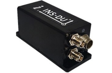
The new INS-DU delivers high-accuracy RTK positioning for air, land and marine applications
Photo: Inertial Labs
Inertial Labs has released a new GPS-aided inertial navigation system (INS). The INS-DU is a high-performance strapdown system that determines position, velocity and absolute orientation to any platform it is mounted to.
The INS-DU has a dual-antenna u-blox GNSS receiver that provides 1-cm real-time kinematic (RTK) position from RTCM 3 RTK corrections and supports a wide range of GNSS constellations.
Designed for UAVs, land vehicles and marine vessels, the INS-DU is an effective, low-cost solution that uses a range of aiding data for different applications. With highly accurate navigation in GNSS-denied environments, the INS-DU delivers a cost-effective GNSS-denied solution, according to Inertial Labs.
One of the key elements to the success of the INS-DU is its use of the miniAHRS, which utilizes 3-axes each of precision magnetometers, accelerometers and gyroscopes to provide orientation of the device under measure. It contains cutting-edge algorithms for the motion of robots, unmanned and autonomous vehicles, and antennas.
MiniAHRS mini fluxgate magnetometers have an advantage over commonly used magneto-inductive or magneto-resistive alternatives and have been a trusted North reference for more than 70 years.
The INS-DU provides a full navigation solution for both GNSS and GNSS-denied environments. With custom interfaces and a power consumption of two and a half of a Watts, the INS-DU is a versatile solution fit for a wide variety of users with power consumption restrictions.
In addition, the INS-DU contains our on-board sensor-fusion filter, state-of-the-art navigation, and guidance algorithms and calibration software.
A new offshore service opportunity for an already proven mini-helicopter UAV, a possible alternative to flying cars, and bulking up UAVs to carry cargo – just a few of this month’s new developments in unmanned aircraft.
Oil Services UAV?
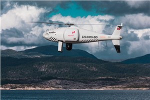
S-100 Camcopter. (Photo: Schiebel)
If you’ve ever gotten close to the Schiebel Camcopter S-100, such as at a trade show, or if you’ve worked with one, you’ve probably noticed that it’s a rugged, weather-hardened vertical take-off UAV.
It would seem that both military and maritime operations would be natural applications — so it’s not surprising that the United Arab Emirates (UAE) Army and German Navy have both bought S-100s.
The U.S. Air Force Research Laboratory (AFRL) also investigated use of the S-100 for detection of improvised explosive devices (IED).
The S-100 is a vertical take-off and landing, unmanned mini-helicopter with a top speed of around 138 mph, a range of just over 100 miles, with two payload bays, an electronics bay, and the ability to carry underslung loads — the all-up payload is 110 pounds. Sensors include an electro-optical/infrared (EO/IR) camera, an electronic support measures (ESM) system for detection and identification of electronic signatures, and synthetic-aperture radar (SAR).
So it’s no surprise that a recent trial demonstrated the S-100’s long-range, high-speed capabilities to deliver parts to a Norwegian offshore oil rig.
Nordic Unmanned and Schiebel flew a demonstration S-100 for rapid delivery of a 3D-printed replacement part from Mongstad out 55 miles to the gas production platform Troll A in the North Sea. This is said to be the first full-scale offshore UAV delivery from shore to an active oil and gas installation.
The demonstration simulated an urgent requirement for a nozzle holder for injecting diesel fuel into the platform’s lifeboat engine. Maintaining safety regulations and production flow from these offshore platforms is essential, but both ship and helicopter emergency trips out to platforms can be risky and downright dangerous in bad North Sea stormy weather — so the UAV option may save lives, time and cost.
Before flying back to base on the mainland, the S-100 also demonstrated its ability to closely inspect the operational platform, and even carried out a simulated search and rescue, locating a dummy in the water and providing live video and location data from its L3 Harris EO/IR camera and an Automatic Identification System (AIS).
Do we really need flying cars?
Where are we with people-carrying drone taxis and cars? To get them in the air for demonstration flights is tricky — there are a lot of i’s to dot and T’s to cross before agencies like the U.S. Federal Aviation Administration (FAA) allow them to fly. There are also plenty of restrictions on where they can fly — certainly not over populated areas. It will undoubtedly happen eventually, but time is money, and regulations will likely outlast the financial supply for most start-ups.
Because of this, one outfit with significant credentials has taken another tack — automating aircraft that have already earned their certified wings.
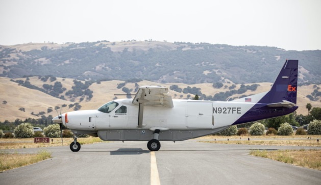
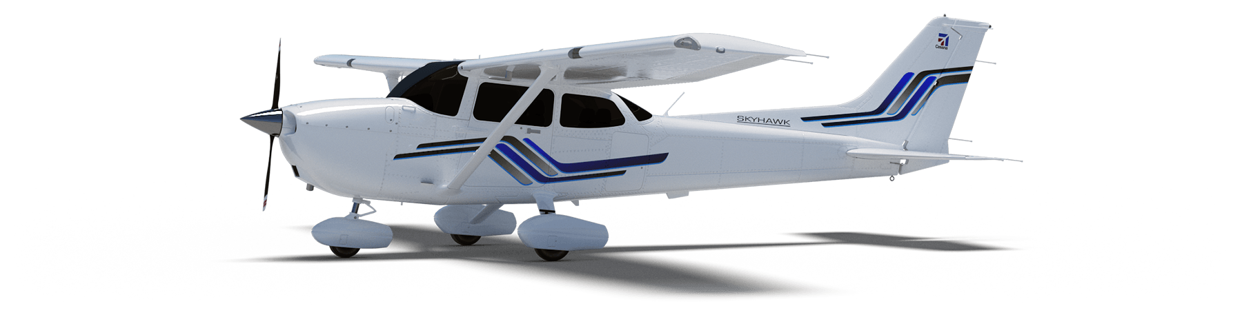
The original Cessna 172 Skyhawk test flights and certifications successfully culminated in June 1955. The Cessna 208 Caravan gained FAA approval in October 1984. Both General Aviation aircraft have flown since then with established safety and reliability records. The FAA knows what makes a safe airframe, power plant and aircraft flight controls — what’s needed to qualify a remotely piloted, automated flight control system is surely a lot less than the complete aircraft and its existing systems.
Ex-SpaceX software systems director Robert Rose decided that getting his autoflight system past FAA scrutiny would actually be an easier job. He started Reliable Robotics to get drone aircraft flying sooner.
The company has now developed an autonomous platform that can be retrofitted into virtually any fixed-wing aircraft. The system comprises avionics, flight control software, a mechanical hook-up, and a communications system which enables remote command and control, along with a reversionary backup system.
The autonomous system was integrated into a four-passenger Cessna 172 Skyhawk, and was used in an automated, unmanned gate-to-gate demonstration flight. The system underwent a full system safety analysis and test and the unmanned test flight included automatic taxiing, takeoff and landing.
The Skyhawk was flown without a pilot on board over a populated area, which was an essential part of qualifying the Reliable Robotics platform for safe civil use on an already certified passenger aircraft.
For the next test flight of a larger 14-passenger Cessna 208 Caravan, the integrated system again demonstrated full automatic remote landing of the aircraft. Reliable Robotics hopes that continuing certification efforts with the FAA will soon enable them to sell their automation system for certified unmanned passenger aircraft operations.
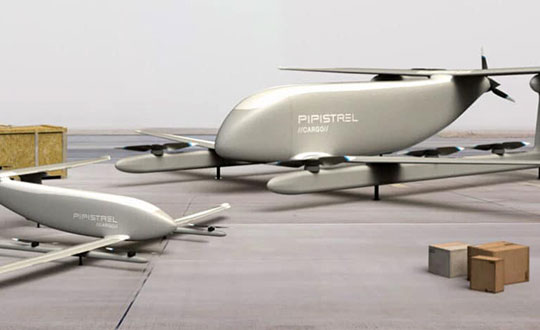
Cargo UAV
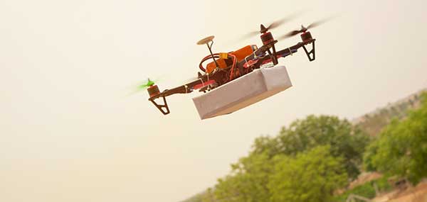
The majority of unmanned aircraft have been small. There’s even a category called small unmanned aircraft systems (sUAS) — so hanging a pizza on one for delivery by suppertime is about the most cargo you might imagine these things could carry.
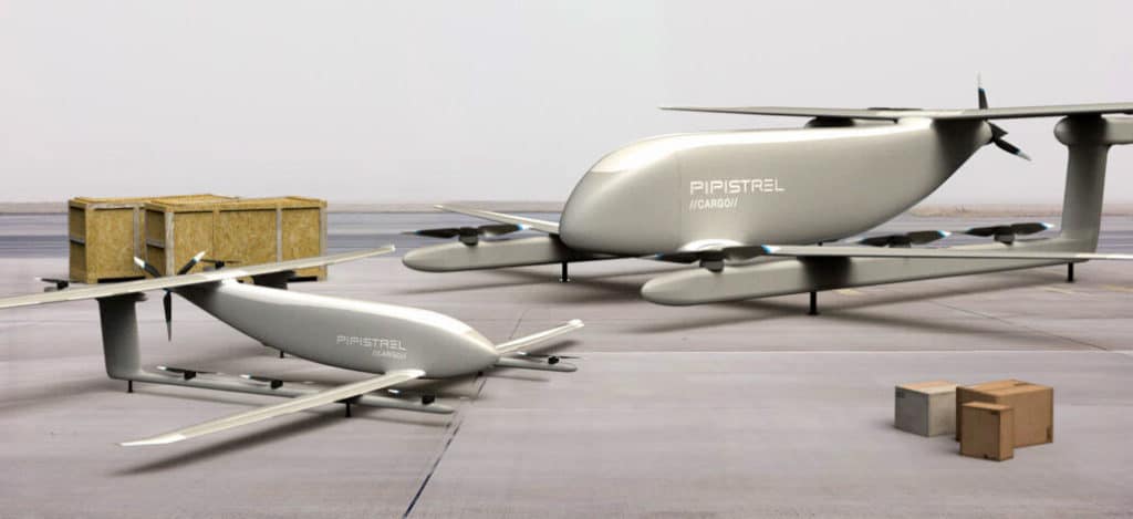
V20 and V300 cargo UAVs. (Artist’s concept: Pipistrel)
One way to overcome this limitation — as we just saw — is to hook up a sophisticated auto-flight system to a passenger aircraft. Another way could be to build a large cargo-carrying UAV — like the Pipistrel (Slovinia) Nuuva V300, which is claimed to be able to carry up to 1000-pounds of cargo over impressive distances.
The vehicle has eight identical electric motors for vertical take-off and landing, and a gas engine powers a pusher propeller for cruise. The vertical lift electric motor has apparently been certified for airborne use by the European Aviation Safety Agency (EASA).
If the V300 cargo is reduced to 110lb, it looks feasible for it to fly over 1500 miles at up to 8,000ft. Pipistrel claims this operational cargo envelope to be 10 times more efficient than for an equivalent helicopter. Pipistrel has also launched a smaller V20 cargo version with the same offset wing set up and smaller electric lift and cruise propulsion — aimed at last-mile deliveries.
Seems the V20 is available fairly soon, but the V300 still has work to do — presumably certification effort – and won’t be available till 2023.
Until next time
So potential oil-platform service deliveries for the S-100 Camcopter, turning already certified aircraft into passenger carrying unmanned vehicles, and UAVs coming for cargo carrying — all are new, promising and different UAV exploits. Let’s hope they all become commonplace in the coming years.
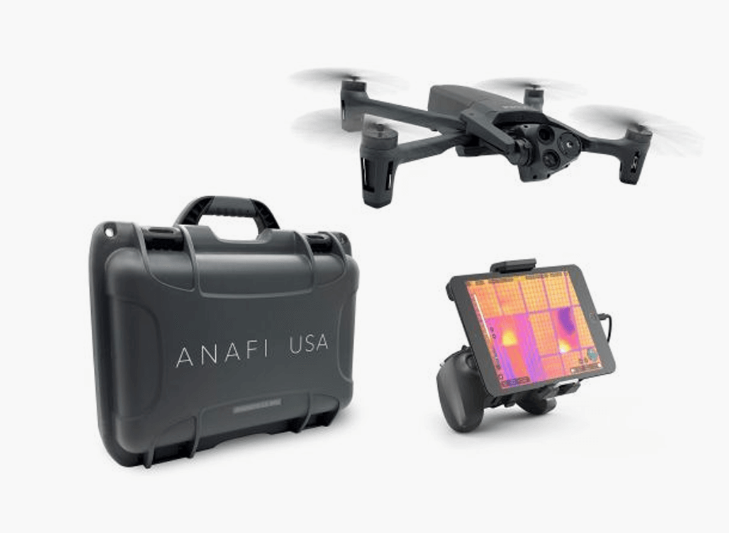
Skyward, a Verizon company, and Parrot, a European drone group, are partnering to deliver Parrot ANAFI drones along with Skyward drone program management, flight-log sync and training to U.S. enterprises.
In particular, the new speaks to a widespread need among U.S. companies and public agencies for a secure, high-end drone manufactured domestically. Sold by Skyward, the ANAFI USA and training package gives enterprises a one-stop shop for building and scaling a drone program with aircraft, policies and procedures, training, and automatic flight log sync to the software platform to manage it all.
“ANAFI USA was designed to meet the needs of the most demanding professional users while offering enterprise data security and privacy,” said Henri Seydoux, founder and CEO of Parrot. “Now, combined with Skyward’s enterprise drone solutions covering training and integrated software platforms, professional users have access to one of the most comprehensive suites of hardware, software and services.”
In addition to its security benefits, Parrot’s ANAFI USA features 32x zoom 4K HDR video and thermal imaging capabilities. It is portable, weather-resistant and ready to launch in seconds.
“Now enterprises can maximize their investment in the ANAFI USA by pairing it with Skyward’s in-person and online operator training and robust management platform,” said Mariah Scott, president of Skyward, A Verizon company. “This is just the beginning of a strong partnership with Parrot. Look for continued feature integration and connectivity offerings as we move the industry forward together.”
Skyward users can automatically log flights from the Parrot FreeFlight 6 piloting application for the ANAFI, ANAFI Thermal and ANAFI USA drones with additional integration features coming soon to maximize the value of both platforms.
A GNSS jamming trial will take place from Sept. 8 through Dec. 4 in and around Luce Bay, at Wigtownshire in southern Scotland, conducted by the United Kingdom’s Civil Aviation Authority.
The trial will affect electronic situational awareness devices, UAS command systems and GNSS receivers.
The activity may affect GNSS receivers along with UAS and cockpit devices operating on 433, 868, 915, 2400, 5800 MHz operating up to 40,000FT AMSL within 55NM of 545020N 045548W (West Freugh).
During the trials, impacted systems may suffer intermittent or total failure. Individual events will not exceed two minutes in duration with no more than five events per hour. Activity will take place in the daytime hours between 0830 and 1600.
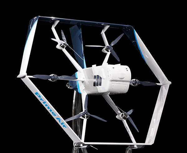
Amazon’s latest delivery drone design was unveiled in June 2019. (Photo: Amazon)
Amazon has received U.S. Federal Aviation Administration (FAA) approval to use drones to deliver packages, which Amazon says will reduce package delivery time to as little as a half-hour.
The approval will give Amazon broad privileges to “safely and efficiently deliver packages to customers,” the FAA said.
Amazon joins UPS and Alphabet-owned Wing, which previously won FAA approval for their drone delivery operations.
The approval falls under Part 135 of FAA regulations, which regulates package delivery by drone. All part 135 participants must go through a five-phase process for certification.
“The FAA is encouraging innovation through the Unmanned Aircraft Systems (UAS) Integration Pilot Program (IPP) by working with industry, state, local, and tribal governments to realize the benefits of drones, while informing future rules and regulations,” according to the FAA.
“Participants in these programs are among the first to prove their concepts, including package delivery by drone through part 135 air carrier certification. Part 135 certification is the only path for small drones to carry the property of another for compensation beyond visual line of sight.”
Amazon said it will use the FAA’s certification to begin testing customer deliveries. The company said it went through rigorous training and submitted detailed evidence that its drone delivery operations are safe, including demonstrating the technology for FAA inspectors.
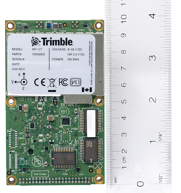
Applanix, a Trimble company, has introduced the Trimble AP+ Air OEM solution for direct georeferencing of airborne sensor data.
The solution enables users to accurately and efficiently produce maps and 3D models without the use of ground control points.
The Trimble AP+ Air is a powerful solution for manned platforms, yet small enough for use on unmanned aerial vehicles (UAVs). It is also compatible with virtually any type of airborne remote sensor, including photogrammetric cameras, lidar, hyper and multispectral cameras, and synthetic aperture radar.
Comprised of next-generation compact, low-power hardware, the Trimble AP+ Air features dual embedded survey-grade GNSS chipsets, an onboard inertial measurement unit (IMU), an external IMU, and the all-new Applanix IN-Fusion+ GNSS-aided inertial firmware. It is configurable to support the direct georeferencing accuracy demands of low-flying UAVs to high-altitude manned platforms.
“We have taken the most advanced features of Applanix direct georeferencing and Trimble GNSS technology and packaged them into a powerful new, compact and versatile solution,” said Joe Hutton, Applanix’ director of inertial technology and airborne products. “It provides the flexibility required by systems integrators to embed a single hardware solution that can then be configured to meet the different direct georeferencing needs of a specific sensor type, whether flown on a UAV or manned aircraft. It truly is an ‘integrate once, use many times’ solution.”
The Trimble AP+ Air is fully supported by the Applanix POSPac MMS post-processing software, which features CenterPoint RTX post-processing for centimeter-level positioning anywhere in the world without the need for base stations. These capabilities make the solution ideal for integrators to produce a highly efficient airborne mapping system.
For lidar integrators, the Trimble AP+ Air is compatible with the POSPac MMS LiDAR QC Tools for computing boresight as well as adjusting the relative accuracy of the POSPac trajectory being used to generate the point cloud. For integration with cameras, the solution is supported by the POSPac MMS Photogrammetry Tools for computing boresight and performing camera IO quality control.
The Trimble AP+ Air OEM solution and POSPac MMS are available through Applanix sales channels.