The UPP results will provide a proof of concept for UTM capabilities and serve as the basis for policy considerations, standards development and the implementation of a UTM system.
“The demonstrations will help move us closer to safe beyond-visual-line-of-sight drone operations,” said Pamela Whitley, the FAA’s acting assistant administrator for NextGen. “Flight testing UTM capabilities in high-density airspace will help us develop policy for safely and efficiently integrating drones into our national airspace while benefiting and serving communities.”
The demonstrations showcased emerging UTM capabilities that will support beyond-visual-line-of-sight (BVLOS) operations:
The FAA UTM Flight Information Management System prototype and infrastructure, which gives the FAA access to information from industry and other stakeholders.
New technologies and data to validate the latest international standards for remote identification and support authorized users with specific operator data.
In-flight separation from other drones or manned aircraft in high-density airspace to validate recently proposed international UTM standards to help drones avoid each other.
UAS volume reservations to notify drone operators of emergencies and make sure other UTM capabilities work properly in these scenarios.
Secure information exchanges between the FAA, industry and authorized users to ensure data integrity.
Each event attracted more than 100 participants and included local and state elected officials and representatives from international civil aviation authorities. Both test sites collaborated with drone operators and local public safety agencies to demonstrate scenarios that featured various complex UTM capabilities working together to support BVLOS operations with increasing volumes and densities.
MAAP hosted an event on Oct. 28 in partnership with UAS Service Suppliers (USS) AirMap, AiRXOS, ANRA Technologies, and Wing. On Nov. 9, NYUASTS hosted its showcase in coordination with the Griffiss International Airport, Northeast UAS Airspace Integration Research Alliance (NUAIR), and USS partners AiRXOS, ANRA Technologies, AX Enterprize, and OneSky.
The FAA has worked closely with NASA, industry and other stakeholders since 2017 to identify the initial set of capabilities needed to support small drone operations and advance UTM. The FAA Reauthorization Act of 2018 extended the objectives of the program to further enable safe BVLOS drone operations, paving the way for the program.
Stay tuned for more updates on how emerging technologies are being field tested to support the growing UAS industry.
New service provides PPP convergence for centimeter-level accuracy on land, air and marine applications around the world
Research from Hexagon’s Autonomy & Positioning division has resulted in breakthrough innovations in precise point positioning (PPP) that enable nearly instant global centimeter-level accuracy. These developments pave the way to bring “RTK from the Sky” performance to worldwide users through correction service products and GNSS receivers from Hexagon.
RTK from the Sky technology provides the quick accuracy of an RTK solution with the high accessibility and availability of PPP. Users will no longer have geographic or regional infrastructure restrictions — they will be free to operate anywhere around the world with the same premium level of positioning performance.
RTK from the Sky technology removes the traditional PPP barrier of long convergence times as well as internet and radio communication limitations, delivering instantaneous convergence anywhere in the world. This breakthrough establishes the foundation for assured positioning with no downtime in marine, agriculture, and autonomous applications.
To achieve these results, there must be masterful attention to detail throughout the entire positioning ecosystem: no errors conveniently cancelled and no errors ignored. All errors are carefully estimated and removed from the final GNSS position faster and more reliably than ever before.
This end-to-end fine-tuning of measurement quality and error mitigation establishes the foundation for RTK from the Sky performance. No matter the location or application, users will be able to rely upon the highest availability and accuracy of corrections anywhere in the world, without the convergence time, Hexagon said.
“In 2020, PPP has become RTK — without the mobility limitations,” said Sandy Kennedy, VP of Innovation at Hexagon’s Autonomy & Positioning division. “RTK from the Sky has been a very satisfying development. To see this kind of positioning performance available anywhere in the world is the realization of the next step of innovation for GNSS.”
RTK from the Sky technology will be the foundation for future correction service products and applications from Hexagon built for diverse applications.
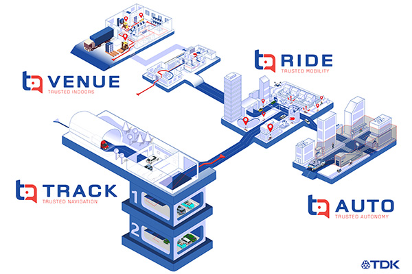
TDK Corp. has announced that Trusted Positioning Inc. (TPI), a TDK Group Company focused on creating and selling positioning software, has joined the New Business Promotion Center of TDK Corporation as an independent business unit.
With the expanding positioning and location tracking market, this move signals TDK’s commitment to developing TPI as an independent software solutions business, according to a TDK press release.
TPI has been developing integrated positioning solutions for decades, with software deployments in more than 50 million systems worldwide. The company’s innovation team is comprised of experts in inertial navigation, dynamic motion mechanics, geomagnetic positioning, GNSS, Bluetooth low energy, Wi-Fi and other wireless positioning techniques.
TPI’s inertial navigation solutions provide highly accurate positioning for the autonomous vehicle, automotive infotainment/telematics, robotics, two wheeled micro-mobility and indoor positioning markets.
VENUE (previously Coursa Venue) is TPI’s flagship indoor positioning solution based on inertial, geomagnetic and other wireless technology. The indoor positioning market is exploding with the now-ubiquitous GPS everywhere, except indoors. TPI’s indoor positioning requires minimal infrastructure investment, which reduces costs, and is well suited to scale for large venues.
RIDE is TPI’s two wheeled micro-mobility solution (previously called MML) for the burgeoning rental bike and electric scooter industry. This software solution enables the return and location identification of vehicles in urban areas where GPS is less accurate, and facilitates correct orientation of parked bikes to ensure city standards are met.
TPI’s TRACK product (previously named IPL), fuses GNSS and an IMU to provide accurate dead reckoning for automobile infotainment and telematics systems during GNSS outages in tunnels, underground parking and other sheltered areas.
TPI’s AUTO solution (previously known as Coursa Drive) improves reliability in autonomous vehicles and robots utilizing onboard radar and inertial sensors. AUTO provides all weather decimeter level positioning accuracy in urban areas with limited GPS signal availability.
With the introduction of TPI’s new structure and product names, today TPI also launches a new dedicated website: www.trustedpositioning.com.
“Relaunching our business and brand while leveraging a SaaS business model, partnering with major companies around the world and keeping them competitive, marks a strategic move for TPI”, says Chris Goodall, managing director and founder of TPI.
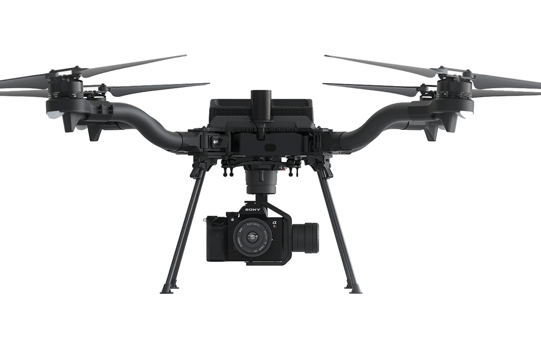
Esri is offering two major capabilities in Site Scan for ArcGIS that will enable governments and critical infrastructure organizations to meet hardware and software regulations in the United States and Europe. Site Scan is Esri’s unmanned aerial systems flight planning and processing solution.
Through an established partnership with Auterion, creator of an open-source drone autopilot operating system, security-conscious U.S. organizations will be able to use Site Scan to plan and execute missions with Auterion’s Freefly Astro drone.
In Europe, data from publicly funded or critical infrastructure projects cannot leave the European Union (EU). For these organizations, a new and fully independent instance of Site Scan for ArcGIS has been deployed to a server cluster in Ireland, ensuring that organizational data resides within the region.
Site Scan for ArcGIS is used by organizations that require drone imagery for visual inspections, site monitoring, asset management and situational awareness. It’s an all-in-one, cloud-based drone mapping solution for managing fleets and collecting, processing, analyzing, and sharing data products. Industries using this solution include architecture, engineering, construction, natural resources, infrastructure and government.
Freefly Astro uses U.S. Department of Defense-approved Blue sUAS software architecture from Auterion, and is fully supported by Site Scan. The first vehicle integrates the software with the Freefly Astro, with more vehicles becoming available.
Auterion’s secure, integrated workflow for mapping uses the Freefly Astro drone, Sony A7R4 camera and Esri Site Scan within a single platform.
The Freefly Astro and Site Scan integration will be available by December. The European deployment of Site Scan is available now.
The 10-minute-long drone show included a flying dove with a wingspan of 600 meters, visible from three kilometers away. (Photo: u-blox)
U-blox supplied the high-accuracy technology that made it possible to fly a massive swarm of drones. The simultaneous flight of 2,198 miniature unmanned aerial vehicles (UAVs) was launched into the night sky over Saint Petersburg, Russia, on Sept. 3.
The 10-minute-long drone show included a flying dove with a wingspan of 600 meters, visible from three kilometers away.
Geoscan, which built and programmed the drones and ran the display, chose u-blox positioning technology for its combination of accuracy, reliability, performance and ability to access positional data from both the GLONASS and GPS satellite navigation constellations.
The 10-centimeter-wide Geoscan Salute drones were designed for use in group flights and drone shows. The drones use u-blox NEO-M8P high-precision GNSS modules to provide the positioning data to create a fluid drone show. Salute drones return to their base stations automatically at the end of a show.
The NEO-M8P module implements a real-time kinematic (RTK) approach that improves positional accuracy by comparing the phase of a signal being broadcast from a positioning satellite with that of the same signal that has been received and rebroadcast from a fixed base station. The accuracy gained in this way enables drones to calculate their relative positions to within millimeters, and their absolute positions to within 1 centimeter of the intended position.
Geoscan has been producing drone displays for the past two years, starting with 40 drones flying at once. “The u-blox modules in our Geoscan Salute drones have improved our drones’ positioning accuracies to about one centimeter, and have helped reduce pre-launch preparation time,” said Semen Lapko, head of Drone Show Project, Geoscan. “Drones now move more quickly and accurately, while also operating more efficiently.”
A roundup of recent products in the GNSS and inertial positioning industry from the November 2020 issue of GPS World magazine.
OEM
GNSS receiver
Sub-decimeter accuracy without additional service subscription
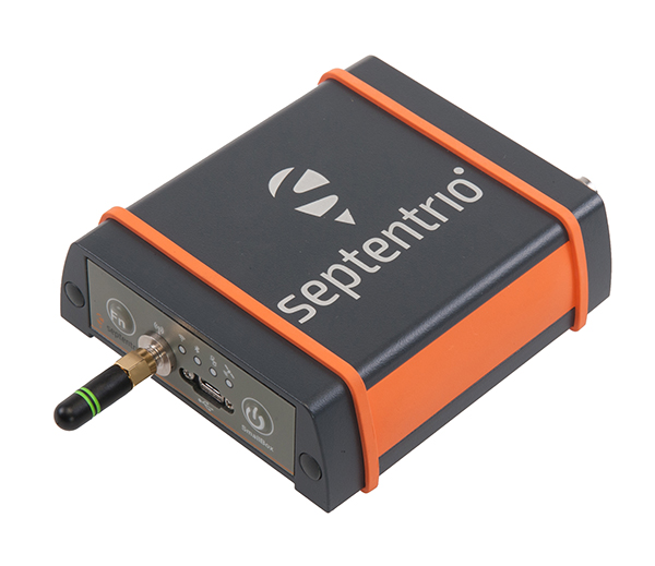
The AsteRs-m2-Sx. (Photo: Septentrio)
The SECORX-S product line, which first offered GNSS OEM boards, now also includes a compact mosaic-Sx module and ruggedized receiver in an IP68 chassis, the AsteRx SB Sx. The multi-constellation multi-frequency SECORX-S receivers deliver sub-decimeter positioning without the need for additional correction service subscription or maintenance. The PPP-RTK correction service is integrated directly into Septentrio’s core GNSS technology. The addition of modules and boxed receivers to the SECORX-S line providesz accurate positioning to applications such as precision agriculture, UAVs, robotics and construction.
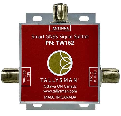
Smart Power GNSS signal splitters improve GNSS service reliability and minimize service interruptions. The professional-grade splitters — TW162 (one antenna/two receivers) and TW164 (one antenna/four receivers) — offer system redundancy and fail-over capability. The splitters are designed to improve GNSS service reliability and reduce signal reception failures. Both splitters offer system redundancy and fail-over capability. They support GPS/QZSS-L1/L2/L5, QZSS-L6, GLONASS-G1/G2/G3, Galileo-E1/E5a/E5b/E6, BeiDou-B1/B2/B2a/B3 and L-band correction services.
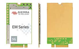
The EM919x 5G NR Sub-6 GHz and mmWave embedded modules include an integrated GNSS receiver. Based on the industry-standard M.2 form factor, the modules will enable original equipment manufacturers (OEMs) to securely deploy 5G connectivity worldwide at the highest possible speeds with ultra-low latency for routers and gateways. The modules support mmWave, sub-6 GHz and LTE, as defined by the 3GPP Release 15 standard. Applications include private networks, enterprise networking, edge processing, live streaming, video security, e-gaming, smart factories, robotics, drones, virtual reality, machine learning, and new Industrial IoT applications.
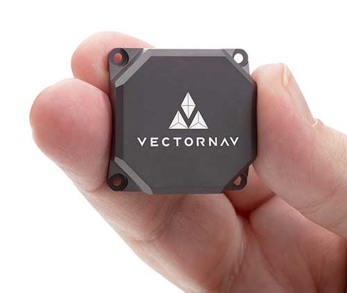
Tactical Embedded series of GNSS/IMUs. (Photo: VectorNav)
The Tactical Embedded series of GNSS/IMUs feature a tactical-grade inertial measurement unit (IMU) and a multi-band GNSS receiver. The line delivers milliradian attitude accuracy and centimeter-level positioning capability in a miniature 15-gram package. The small size enables cost reductions for a range of autonomous pointing and geo-referencing applications such as gimballed intelligence, surveillance and reconnaissance (ISR); satellite communication systems; lidar mapping; and photogrammetry. The line supports external SAASM GPS for defense applications in ISR, electronic warfare, munitions and UAV navigation. The line includes the VN-110E IMU/AHRS, the VN-210E GNSS-aided inertial navigation system (INS), and the VN-310E dual-antenna GNSS/INS.
VectorNav Technologies, vectornav.com
GNSS/INS Sensor
Designed for dynamic environments
Photo: CHCNAV
The CGI-610 GNSS/INS high-precision dual-antenna receiver offers reliable and accurate navigation and positioning for demanding land, marine and aerial applications. The tight fusion of the latest GNSS technology with an industrial-grade MEMS IMU is powered by CHCNAV’s algorithms to deliver accurate hybrid position, attitude and velocity data, even in complex and obstructed environments where GNSS outages can occur. The CGI-610 supports data output up to 100 Hz to meet the requirements of highly dynamic applications such as airplane, train and automobile. An optional external odometer sensor for ground vehicles can provide an additional measurement of displacement and speed, which is fused with the GNSS/INS navigation solution.
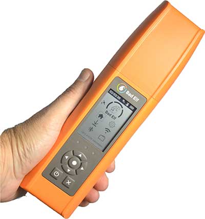
Bad Elf Flex is a scalable-accuracy GNSS receiver with a daily option to choose between L-band and real-time kinematic (RTK). In standard configuration, it achieves 30-60 cm accuracy in real time for GIS use. Consuming a Bad Elf Flex Token unlocks a full RTK workflow for a 24-hour period to deliver 1-cm horizontal accuracy. Bad Elf Flex stores the tokens directly on the receiver, making them available for use anytime. Customers requiring high accuracy at all times can purchase the Bad Elf Flex Extreme bundle, with RTK capabilities permanently unlocked, for a one-time upgrade fee.
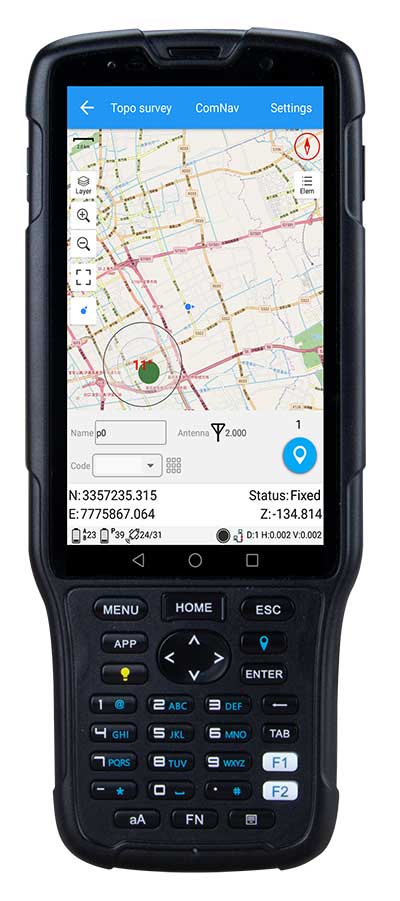
The R550 data collector features an industrial-level design and new hardware platform to ensure efficiency and productivity in the field. The IP67 dust-and-waterproof rating protects the R550 from most harsh environments. Equipping it with a 7,000 mA Li-ion battery allows more than 14 hours of continuous operation, while fast-charging technology means four hours for a full charge. The 5-inch-wide sunlight-readable, high-resolution screen provides a smooth experience for any operation. The integrated autofocusing camera helps enhance job documentation by taking photos on site and sharing job information with colleagues. Survey Master field software available on the R550 controller ensures efficient surveys in the field, including topographic surveys, stakeouts, coordinate geometry (COGO) and more. Powered by the Android 8.1 operating system and designed with 4G RAM, 64GB ROM and 4G/BT/Wi-Fi on board, users can run other third-party apps based on their specific requirements.
The Trimble AP+ Air OEM solution provides direct georeferencing of airborne sensor data and enables users to accurately and efficiently produce maps and 3D models without the use of ground control points. It is designed for manned platforms, yet small enough for use on UAVs. It is also compatible with airborne remote sensors, including photogrammetric cameras, lidar, hyper- and multi-spectral cameras, and synthetic aperture radar. The Trimble AP+ Air features dual embedded survey-grade GNSS chipsets, an onboard inertial measurement unit (IMU), an external IMU, and the new Applanix IN-Fusion+ GNSS-aided inertial firmware. It is configurable to support the direct georeferencing accuracy demands of low-flying UAVs and high-altitude manned platforms. Trimble AP+ Air is supported by Applanix POSPac MMS post-processing software with CenterPoint RTX post-processing for centimeter-level positioning anywhere in the world without the need for base stations.
American-made drone aimed at government agencies and military
Photo: Teal
The Teal Golden Eagle drone is designed for short-range surveillance and reconnaissance missions. It features a FLIR Handron dual-camera sensor on a two-axis stabilizer, giving it color vision at 4K 60 fps and thermal vision for extended operations. The payload is hot-swappable. It has a flight time of up to 50 minutes and can fly at speeds of 50 mph with a range of 2 miles. It is able to fly in wind speeds of up to 30 mph and can operate between –32° and 110° Fahrenheit. Forward-facing obstacle avoidance and rear-facing visual-inertial odometry estimates location without the need for GPS. The platform has received approval from the Department of Defense.
A new line of AccuAuto triple-band antennas are designed to provide strong clean code and phase signals to enable high-precision real-time kinematic (RTK) and precise point positioning (PPP) navigation. Model TWA928 supports GPS/QZSS-L1/L2/L5, GLONASS-G1/G2/G3, Galileo-E1/E5a/E5b, BeiDou-B1/B2/B2a and NavIC-L5 signals and frequency bands (the TWA928L includes support for L-band correction services). The AccuAuto line features patented Accutenna technology multi-constellation and multi-frequency antenna elements as well as an integrated ground plane, a radome and an underside cover that provides mist and condensation protection. A deep pre-filter minimizes out-of-band noise and maximizes in-band reception. All AccuAuto components are certified and designed to perform under challenging environmental conditions, such as extreme temperatures (–40° C to +125° C), shock and vibration.
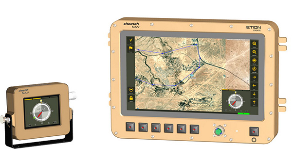
The CheetahNAV provides situational awareness for harsh environments and battlefield conditions, providing the crew of a light military vehicle with highly accurate position information through an advanced inertial measurement system (IMS) comprising several aids, including a gyro-compensated compass and an advanced Kalman-filter-based algorithm. The system provides dead-reckoning horizontal position accuracy of 0.2% of distance traveled in a GNSS-denied situation — accuracy of 200 meters over 100 kilometers. It can integrate with inertial navigation systems (INS). Combined with GNSS and compass information, the system enables dead-reckoning and accurate positioning of the vehicle in tactical situations. The tactical-grade integral inertial measurement unit (IMU) ensures jam-free operation.
The first drone of Europe’s U-space TRACE project took its maiden flight Sept. 23. It carried an EGNOS-enabled beacon that allows the identification of the aircraft while guaranteeing accurate, robust positioning.
The drone lifted off at the ATLAS experimental flight center in Jaén, Spain, an aerodrome equipped for flight tests with unmanned aircraft systems.
The Regional Minister for Economic Transformation, Industry, Knowledge and Universities, Rogelio Velasco said, “This event shows Andalusia’s commitment to hosting initiatives that promote innovation in the region.”
Using enhanced EGNOS signals, the EU’s regional satellite-based augmentation system, TRACE supports the safe and effective integration of drones into U-space by providing essential services such as e-registration, e-identification and pre-tactical geofencing.
The smart beacon allows for remote identification of drones flying at a very low altitude, enabling safer integration of drones into airspace through the use of U-Space. This makes it easier for traditional aviation pilots to know the position of drones. The smart beacon also enables better traffic separation when integrated with U-space services, thanks to EGNOS.
“TRACE is a pioneering project in Europe that will allow us to demonstrate the advantages of EGNOS, particularly in terms of greater precision in locating drones,” said Luis Gómez, CEO of Alter Technology.
The TRACE project is funded by a GSA EGNOS Adoption in Aviation grant. It designed and developed a smart beacon that leverages the robust signal corrections of EGNOS to improve positioning accuracy, and thus the safety of drone operations at very low altitudes.
Carolina Jiménez, TRACE project manager at Alter Technology added, “TRACE will demonstrate compliance with the European Drone Regulation, an important aspect within the Alter business line, since one of the fundamental requirements in this new regulatory framework is that each system has the capacity for remote identification for future secure integration within the air space for these systems (U-Space).
The TRACE project is led by Alter Technology, and is a result of collaboration among European companies such as Unifly (Belgium), Pildo Labs and FADA-CATEC (Spain).
Vodafone, together with CATEC, presented the 5G Lab of ATLAS within the 5G initiative of RED.ES. A use case of 5G with drones for urgent defibrillator delivery was demonstrated with the participation of Fundación SSG, Vodafone and the technological support of CATEC.
TRACE project partners include:
Alter Technology provides engineering and test services for electronic systems and E.E.E. components within the space and harsh environment markets.
FADA-CATEC, the Advanced Aerospace Technologies Center, promotes and develops creation of technological knowledge and its transfer to the productive aerospace industry.
Pildo Labs is an engineering company that specializes in aeronautics and aerospace technology and services.
Unifly is a software company with a platform for the safe integration of drones into the airspace.
The European GNSS Agency (GSA) manages operations, security and service provisions for Europe’s Galileo and EGNOS.
The drone market is expected to outstrip any other user base in the aviation market. According to estimations, revenues from drone-based services are expected to exceed 150 million euros by 2023. GNSS is a key enabling technology for drones and it is expected that its role will continue to grow. Solutions like TRACE that use European GNSS (EGNOS and Galileo) are differentiators that can be leveraged to safely integrate drones into non-segregated airspace and into the U-Space.
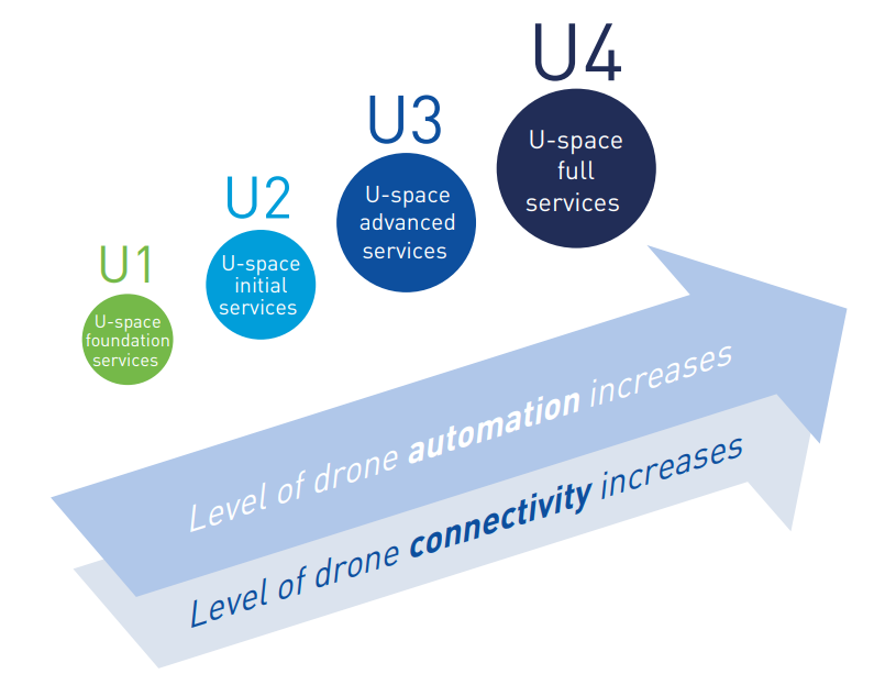
U-space
The progressive deployment of U-space is linked to the increasing availability of services and enabling technologies. Over time, U-space services will evolve as the level of automation of the drone increases, and advanced forms of interaction with the environment are enabled (including manned and unmanned aircraft).
These U-space services have been identified and gathered in four different phases, increasing the drone level of integration. Learn more in the U-space Blueprint.
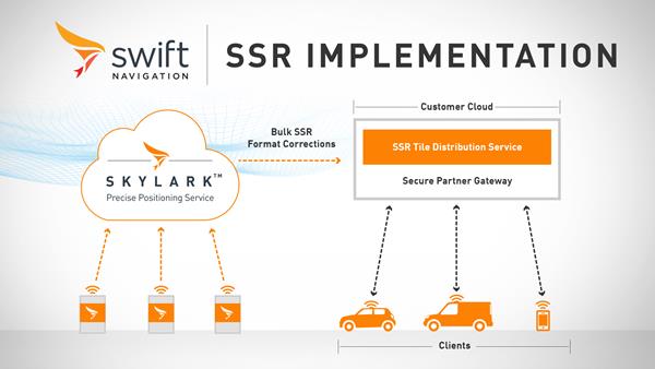
Swift Navigation has launched its production-grade SSR (state space representation) service across Swift’s coverage areas.
Swift is a San Francisco-based tech firm offering GNSS and precise positioning technology for mass-market applications in autonomous vehicles, mobile and internet of things (IoT).
SSR is a bandwidth-efficient format to deliver GNSS corrections to mass-market applications, such as for automotive and mobile customers. It is offered through Swift’s Skylark precise positioning service.
As a new option for corrections delivery available as part of Swift’s precise positioning service, SSR delivers seamless and homogeneous accuracy throughout a coverage area. To date, Skylark delivered corrections in OSR (observation state representation) format for compatibility with legacy equipment but with the introduction of SSR, the power of Swift’s cloud error modeling is now available in its native format.
SSR provides users with fine-grained information about GNSS error sources. SSR divides the coverage region into a series of “tiles” which can be broadcast to all users within that tile, enhancing scalability and minimizing bandwidth while maintaining the utmost security and privacy.
With the capacity to reach millions of connected devices in markets such as mobile and automotive, it is critical to provide both a scalable and secure solution. Swift’s Skylark can deliver bulk corrections data to enterprise customers’ backend for distribution, putting the customer in control of their own users’ privacy and security.
Swift’s enterprise-reference architecture code equips customers with the SSR Tile Distribution Server software that provides a seamless integration path to incorporate SSR corrections into their own cloud or on-premise solution.
Swift’s SSR solution is also based on the open standard from 3GPP. The significance of utilizing the SSR positioning standard from the 3GPP standards body is that it meets the interoperability requirements demanded by mass-market mobile and automotive applications.
“The team at Swift is excited to bring its production-grade, standards-based SSR service to market,” shares Fergus Noble, CTO at Swift Navigation. “The ability to deploy SSR to users in a scalable way, while maintaining privacy, makes it possible for automotive, cellular and IoT mass-market customers to integrate precise positioning into their service offering.”
Skylark is available for integration into wide-area, high-precision positioning applications across the continental United States and Europe and is available in the countries of Japan, South Korea and Australia, with plans to expand globally. Skylark is an ever-expanding service and is scalable to service millions of users. All eligible Skylark subscribers begin with a free trial or pilot program.
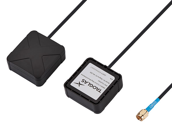
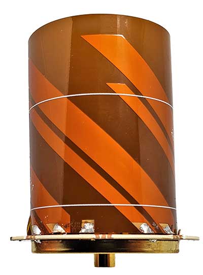
Taoglas has unveiled active, multiband GNSS antennas engineered for applications that require critical high-accuracy positioning and timing, including autonomous driving and precision agriculture. Both the MagmaX2 AA.200 and Colosseum X XAHP.50 add to Taoglas’ high-precision GNSS range.
“Safety standards for autonomous vehicles (UAVs, robotics and vehicles) and precision agriculture is an ever evolving arena,” said Ronan Quinlan, co-CEO and founder of Taoglas. “However, it’s increasingly apparent that high-precision positional accuracy is critical for both. At Taoglas we’re continuously innovating our GNSS antennas to deliver the very best precise location capabilities, but in more lightweight, compact structures, compared to larger counterparts already on the market. We look at the impact the antenna has on the actual positioning performance of your system, not just the antenna itself.”
The MagmaX2 AA.200. (Photo: Taoglas)
The MagmaX2 AA.200 is designed for space and weight constrained applications, such as robotic lawnmowers, Quinlan said. Embedded antenna versions are also available.
The AA.200 is a low-profile active multiband GNSS magnetic mount antenna for use across most major constellations including GPS (L1/L2/L5), GLONASS (G1/G2/G5), Galileo(E1/E5a/E5b) and BeiDou(B1/B2). It exhibits excellent gain and good radiation pattern stability leading to a reliable GPS fix in areas of weaker signal strength.
Positional accuracy better than 60 cm (DRMS) is achievable, even without RTK corrections services. Accurate positioning down to 1.4 cm has been demonstrated with today’s multiband GNSS receivers and RTK services in the field.
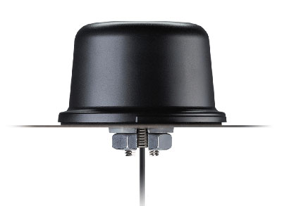
The Colosseum X XAHP.50 antenna. (Photo: Taoglas)
The Colosseum X XAHP.50 is a geodetic-quality small-dome antenna suitable for a vehicle roof mount or pole mount. “Every element and aspect of the antenna performance has been optimized during the design of this antenna,” Quinlan said. “This includes many deep interlocking rf parameters for true accurate centimeter-level positioning, compared to legacy meter-only level systems. Phase center variation, group delay, multipath rejection, axial ratio over angle all become critical considerations and performance targets.”
The XAHP.50 is engineered to operate with incredibly high precision capabilities on the full GNSS spectrum. Sub meter positional accuracy better than 55cm (DRMS) is achievable, even without the use of RTK correctional services. This allows the user to achieve higher location accuracy, as well as stability of position tracking in urban environments.
The XAHP.50 has excellent performance across the full bandwidth of the antenna and its design has an even gain across the hemisphere giving excellent, broad axial ratio which in turn makes it resilient to multipath rejection and excellent phase centre stability. Accurate positioning down to 1.4 cm has been demonstrated with today’s multiband GNSS receivers and RTK services in the field.
Antenna Development
“In the design phase we simulate using electromagnetic analysis software and tweak every parameter,” Quinlan said. “Once we are happy with the results, we build our prototypes and test in scientifically controlled chamber and test environments validated by the European Space Agency, with repeatable GNSS signals.
“We then move onto field testing in open-sky conditions and in non-line of sight environments to verify real-world performance with today’s state-of-the-art receiver systems from such leading companies as u-blox and Septentrio.
What’s more, every single antenna coming off our production line goes through strict in-line sensitivity testing to ensure consistent validated performance. We take our commitment to quality and safety very seriously in the coming age of autonomous operation,” Quinlan concluded.
Partnership combines Aceinna’s integrated precise positioning and advanced guidance expertise with ST’s products, technologies and solutions.
Innovative sensing technology company Aceinna Inc. has joined the STMicroelectronics Partner Program to make its inertial measurement unit (IMU) and real-time kinematic (RTK) precise positioning solutions available to engineers and developers working on next-generation solutions that safely and accurately position autonomous automobiles, trucks, robots and delivery vehicles.
Aceinna is also participating in the Virtual ST Developers Conference on Oct. 20 and Oct. 21 from 8:30 a.m. to 4 p.m. ET, which discusses precise positioning for autonomous vehicles. Register here.
“By leveraging ST technology, Aceinna is providing customers with vertically integrated performance sensing platforms,” said Yang Zhao, CEO of Aceinna. “These system-level solutions help customers greatly accelerate development time as well to reduce the time to market for new autonomous vehicle technologies.”
“The ST Partner Program helps customers’ design teams access extra skills and resources to aid engineering development and shorten time-to-market for new products,” said Alessandro Maloberti, partner ecosystem director, STMicroelectronics. “By selecting, qualifying, and certifying our program partners like Acennia Inc., we are taking yet another major step in helping customers accelerate design and development, and ship to market the most robust and efficient products and services.”
STMicroelectronics, a global semiconductor leader serving customers across the spectrum of electronics applications, created the ST Partner Program to speed customer development efforts by identifying and highlighting to them companies with complementary products and services. The program’s certification process assures that all partners are periodically vetted for quality and competence.
A roundup of recent products in the GNSS and inertial positioning industry from the October 2020 issue of GPS World magazine.
OEM
GNSS antennas
Active and passive
Photo: 2J Antennas
A new range of high-precision GNSS antennas is designed for superior accuracy and reliability, with both active external antennas and passive internal ceramic antennas. The antennas provide precision, high bandwidth, and an advanced signal design for GPS, GLONASS, BeiDou, Galileo, IRNSS and SBAS navigation. They are designed for demanding GPS applications that require centimeter-level accuracy by combining precise point positioning (PPP) of L1 and L2 or by combining L1 and L5 bands with real-time kinematic (RTK) satellite navigation. Applications include aviation safety, UAVs, transportation, autonomous vehicles, agriculture and land and hydrographic surveys.
The HC976 housed and HC976E embedded helical antennas are light and compact, suitable for applications ranging from autonomous navigation to GNSS timing. Both models support GPS/QZSS-L1/L2/L6, GLONASS-G1/G2, Galileo-E1/E6, and BeiDou-B1/B3 frequency bands as well as regional augmentation systems and high-precision L-band correction services. The HC976 and HC976E support QZSS-L6, Galileo-E6 and BeiDou-B3. The HC976 is 44 x 62 millimeters and weighs 42 grams. It features a precision-tuned helical element that provides an excellent axial ratio and operates without the requirement of a ground plane, making it suitable for a wide variety of high-precision applications.
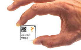
The mosaic-T GPS/GNSS receiver module is built for resilient and precise time and frequency synchronization under challenging conditions. Its multi-frequency, multi-constellation GNSS technology with AIM+ Advanced Interference Mitigation algorithms allows mosaic-T to achieve maximal availability even in the presence of GNSS jamming or spoofing. The compact surface-mount module is designed for automated assembly and high-volume production. Mosaic-T delivers timing and has additional inputs for an external high-accuracy clock.
The HGuide n380 inertial navigation system (INS) communicates an object’s position, orientation and velocity when GNSS signals are unavailable. It is built to withstand harsh environments in the air, on land or at sea. It is designed to meet the need for a small, high-performance INS for 3D mapping, surveying and other applications where space is at a premium. It is composed of Honeywell’s HGuide i300 inertial measurement unit (IMU), a GNSS receiver and Honeywell’s proprietary sensor-fusion software, which is based on the algorithms used for navigation on millions of aircraft every day.
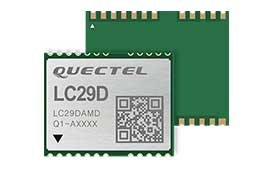
The LC29D eMobility module is a sub-meter-level GNSS module that integrates dead-reckoning and multi-band (L1/L5) real-time kinematic (RTK) algorithm technologies with fast convergence times and reliable performance. The module supports dual-band GNSS raw data output and integrates a 6-axis IMU sensor to deliver high-accuracy positioning performance in seconds. Based on the Broadcom BCM47758 GNSS chip, the LC29D can concurrently receive signals from up to six constellations (GPS, GLONASS, Galileo, IRNSS, BeiDou and QZSS), which maximizes the availability of sub-meter level accuracy. It offers a position update rate of up to 30 Hz (fusion output), enabling dynamic applications like shared emobility, delivery robots and precision agriculture to receive position information with lower latency.
The AlphaUni 300/900/1300 lidar series provides light, versatile long-range laser scanner systems for the high-end market. The series provides optimized data sets powered by advanced GNSS/inertial navigation system (INS) sensors and long-range Riegl scanners. AlphaUni’s design adapts to a variety of applications and can be installed on a variety of platforms, including multi-rotor UAV, fixed-wing vertical-takeoff-and-landing (VTOL) UAV, vehicles, rail trolleys, backpacks, boats and more.
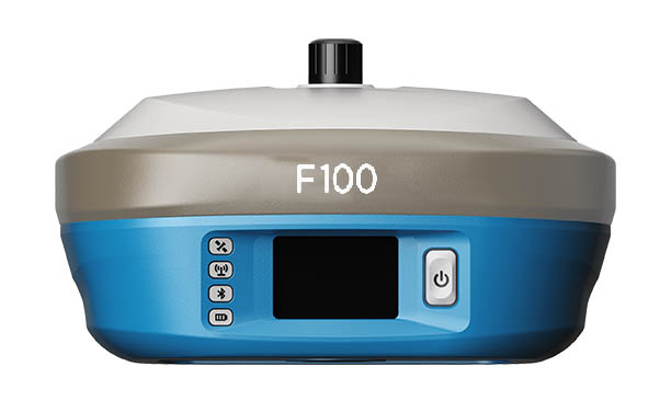
The F100 GNSS receiver, an upgrade to the F90, is designed to meet surveyors’ demands for high field performance, flexibility and cost-effectiveness. It tracks multiple constellations (GPS, GLONASS, Galileo, BeiDou) and can maximize the acquisition and tracking process with all-in-view GNSS frequencies. The 1.45-inch color LCD display is a multi-touch capacitive screen. The F100 has 32GB of internal memory. Its integrated second-generation web user interface control is compatible with all devices and browsers.
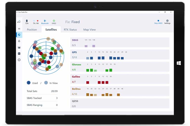
Eos Tools Pro for Windows 10 implements powerful new features that enable users to exploit all four global GNSS constellations and a state-of-the-art NTRIP client to access real-time kinematic (RTK) bases and RTK networks all over the world via NTRIP, Direct IP and wireless radios. It provides the latest support for Windows Geolocation and other features by Microsoft to allow customers to use high-accuracy locations directly in their apps, such as RTK network/RTK base connectivity, support for all new Beidou and Galileo satellites, and SafeRTK functionality for areas with marginal cellular coverage. Features for app developers are also available.
The BB4 UAV high-end multi-rotor drone is optimized for the AlphaUni 300/900/1300 lidar series. Its modular design simplifies deployment in just a few minutes. Its 7-kg payload breaks the capacity barrier, and its more than 45 minutes of flight time increases the airborne lidar survey ability. The redundant CHCNAV and DJI inertial measurement unit (IMU) and GNSS unit provide reliable centimeter real-time kinematic (RTK) positioning, meeting the demand for high accuracy in the geospatial and mapping industries.
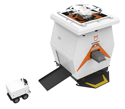
The ADNET autonomous delivery network is a technical solution to transport medical samples and quarantine materials in cities. It uses an RA3 drone, unmanned vehicle RG1 and RH1 hub station to deliver medical supplies without relying on manpower, alleviating time spent in traffic and the cost of traditional delivery. Supplies retrieved by the RG1 vehicle are delivered to the RH1 hub for sorting and redirecting, while the drone transfers the supplies between hubs. The RG1 then delivers goods on the receiving end. The system was demonstrated during China’s COVID-19 epidemic prevention and control period, reducing contact between samples and personnel.
The VECTOR-400 is a compact autopilot designed specifically for unmanned aerial vehicles. It features a robust enclosure and a military-grade connector for harsh environments (MIL-STD 810 and MIL-STD 461). Features enable sea-skimming (extremely low-level flight) and the capability to navigate without GNSS. The VECTOR-400 is able to continue a mission in case of individual sensor failure and when subject to jamming, maintaining accurate estimations of attitude and position. Advanced algorithms provide stall prevention and the ability to carry out an efficient gliding maneuver in case of engine failure. Its air data attitude and heading reference system and inertial navigation system provide high-precision attitude information and reliable navigation under demanding circumstances.
The F700 DroneHunter UAS is a radar-based autonomous interceptor drone for tracking and stopping dangerous drones. Its flexible undercarriage offers interchangeable counter measures for single, multiple or swarm-based threats, while its lightweight carbon-fiber frame enables quick speed and response. The F700 can carry multiple types of anti-drone countermeasures and deploy them in real time, based on which dynamic threat is detected miles beyond the protected area. The pogo pins and payload snaps of the undercarriage are integrated with artificial intelligence for firing and flight software.
Drones equipped with cost-intensive cameras and sensors need protection in the event of a flight-system failure. A parachute system for the DJI M210 drone is now available. Both commercial and emergency response operations are using the M210; its design and flexibility allow for a variety of industry-specific applications. The DRS-M210 parachute system is designed to ensure high pendulum and wind stability, allowing a damaged drone to land safely with minimal impact.
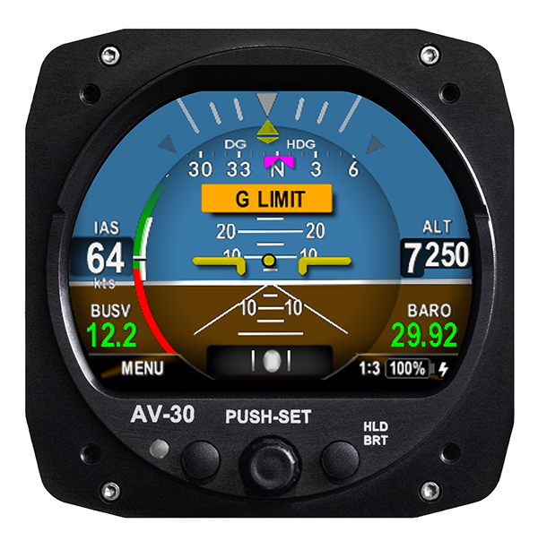
Altitude indicator (AI) or directional gyro (DG) replacement
Photo: uAvionix
The AV-30-C aircraft panel display adds a suite of in-flight information for pilots, including GPS navigational data, a probeless angle of attack indicator, baro-corrected altitude, indicated/vertical/true airspeed, non-slaved heading, bus voltage and G load. It is designed to fit into any aircraft with a 3 1/8-inch round instrument slot without cutting or modifying the panel. It is authorized for FAR Part 23 Class 1 and Class 2 aircraft listed on the AV-30-C Approved Model List (AML), containing 635 aircraft models including Cessna, Piper, Beechcraft, American Champion, Maule, Boeing, Swift, Mooney, Aviat and others.
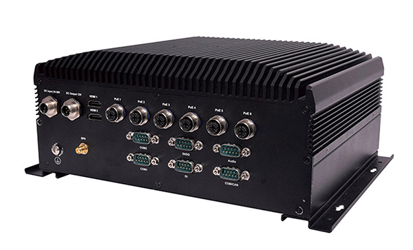
The R3S series of rugged, EN-50155-certified fanless vehicle/rail computers is equipped with a u-blox NEO-M8N module, which receives GPS, Galileo, GLONASS and BeiDou with the default set for GPS + GLONASS dual band. The series offers power-efficient performance for consolidating in-vehicle workloads such as video surveillance, control/monitoring, passenger information and Wi-Fi hotspot sharing. For edge-to-cloud connectivity, R3S uses its internal GPS/GLONASS chipsets for GPS tracking and has two M.2 slots with up to 4x SIM card readers for failover LTE connection. To ensure proper operations in moving vehicles, the series is certified with EN50155, EN50121-3-2, EN50121-4, EN50125-3, EN45545 and E13 standards and has passed MIL-STD-810G shock and vibration resistance certifications. The series can operate under a wide temperature range and offers excellent reliability in harsh railway settings. It has one external removable 2.5-inch HDD/SSD drive bay for recorded footage storage. For consolidating in-vehicle workloads such as in-vehicle control/monitoring and passenger information, the R3S features a variety of I/O support, including 2x HDMI, DI/DO, 3x COM/CAN BUS and 4xUSB ports.
GNSS augmentation solution targets North America and Europe with safe and precise centimeter-level accuracy performance from two geostationary satellites.
Sapcorda Services GmbH is now testing its GNSS augmentation services for the L-band signal in North America and Europe. The testing lays the foundation for a Dec. 1 launch of what Sapcorda said will be the strongest, most reliable GNSS augmentation signal for safety-critical navigation in autonomous vehicles and machinery.
Available in areas without GSM coverage or mobile internet signal, the new Sapcorda L-band beam solutions from two geostationary satellites provide PPP-RTK data-feed redundancy in real-time by swapping to a second data feed when internet connectivity is not available. This automated swapping significantly improves reliability for life-critical applications such as autonomous cars.
“To use GNSS in mass-market safety-critical applications, manufacturers need GNSS augmentation services that provide correction data with safety-critical positioning,” said Botho zu Eulenburg, CEO, Sapcorda. “By expanding our SAPA services with L-band transmission, we enable a high-power correction data stream for homogeneous performance and end-to-end data security with continental coverage in the United States and Europe — thus improving accuracy, reducing convergence time, and enabling the use of lower-cost receivers and antennae.”
The Sapcorda L-band signal will be transmitted in the open SPARTN format, a format specifically developed for IP-based and geostationary satellite distributions. It will be invaluable for safety-critical applications in automotive (such as V2X and autonomous driving, AD/ADAS) and maritime, as well as a wide variety of uses across sectors such as industrial, robotics and drones.
The L-band satellite beam coverage will be available on December 1, 2020. Sapcorda’s safe and precise augmentation (SAPA) service will broadcast SAPA Basic and SAPA Premium correction data streams.
These data streams feature:
99.9% service availability with fast convergence and an accuracy of less than 10 cm, delivering the precision required for safety- and life-critical applications
Redundancy through dual data streams when internet connectivity isn’t available, ensuring uninterrupted broadcast streaming
Demodulation by any L-band demodulator on the market, simplifying hardware design and reducing bill of materials
Availability of service coverage areas in North America and Europe, allowing manufacturers to use a single GNSS augmentation services’ solution for major global regions
Distributed in the same open format as IP-delivery channels (SPARTN)
Sapcorda’s SAPA services are supported by experienced engineering teams dedicated to systems integrators and enterprise business customers. The Basic and Premium SAPA services for L-band signal operation begins in both regions on Dec. 1.
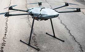
 The Federal Aviation Administration (FAA) has concluded the second phase of its Unmanned Aircraft System (UAS) Traffic Management Pilot Program (UTM/UPP).