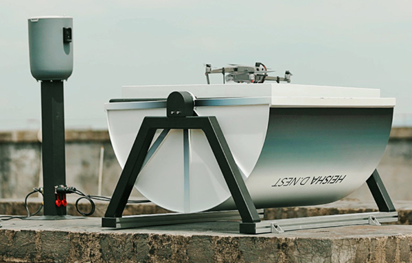
Heisha, a drone-charging solution and unattended drone system provider, has launched a new drone-in-the-box hardware platform, D.NEST.
D.NEST is an automatic drone-in-the-box hardware platform compatible with DJI drones, open-source project drones and vertical take-off and landing (VTOL) aircraft.
Based on Heisha’s third-generation charging pad C500, D.NEST is a reliable and stable automatic drone charging solution. Equipped with a built-in AI computer, remote-control base and local router, D.NEST is easy to maintain and redevelop, according to the company. Additionally, the hardware platform can be a data center and control center for different robots.
Heisha operates an open-source interface API and SDK, making it flexible. Designed for use with the DJI Mavic and Phantom series, D.NEST can also be customized for use with the M200, M210, M300, M600, open-source UAVs and VTOL fixed-wing UAVs.
Equipped with the 5-in-1 PCB control K100 and industrial-level materials, Heisha also provides a useful, stable and cost-effective drone-charging platform.
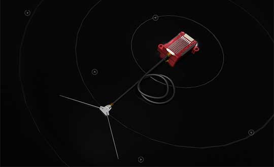
RedTail Lidar System’s RTL-400 delivers the trifecta
Summer is here, and with it comes the challenge of creating accurate topographic maps under tree canopies. The adoption of drone-based, 3D light detection and ranging — or lidar — is emerging as the go-to sensing technique to meet this challenge consistently, safely and cost effectively.
Designed specifically for use on small drones, the RTL-400 from RedTail Lidar Systems was developed with technology licensed from the U.S. Army Research Laboratory (ARL). The RTL-400 is designed to provide high-resolution 3D images of objects on the ground, flying at an altitude of up to 400 feet.
The RedTail team recently partnered with the West Virginia Department of Environmental Protection (WVDEP) Division of Mining and Reclamation to demonstrate the RTL-400’s ability to generate an accurate digital terrain model (DTM) under “leaf on” conditions. This can be challenging, because pulsed laser light needs to reach the ground to generate laser light ground returns.
One mission of the WVDEP Division of Mining and Reclamation is to assure compliance with the West Virginia Surface Mining and Reclamation Act and other applicable state laws. This task requires ongoing monitoring, mapping and assessment of sites across the state that are actively being reclaimed.
Originally utilizing photogrammetry to generate point clouds, the WVDEP was unable to create the accurate, under-canopy DTMs that they desired. Looking for an alternate method, they began to consider lidar.
The RedTail lidar team met with WVDEP representatives at a mine reclamation site in a remote area of south-central West Virginia. The terrain was a mixture of rolling hillside covered with grasses, brush and tree stands.
The RTL-400 demonstration flight mapped approximately 20 acres of the reclamation site in 12 minutes, flying at an altitude of 196 feet and a speed of 18 mph.
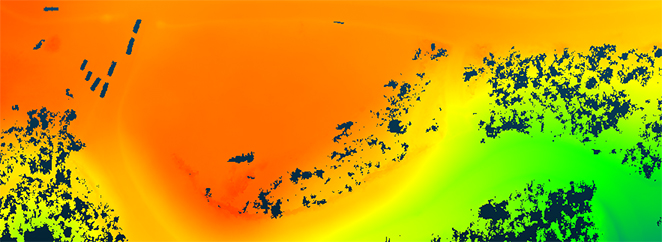
Once the data was collected, a digital terrain model (DTM) was created, revealing the RTL-400’s ability to generate the high-resolution, high-density point cloud needed to accurately map the terrain beneath the tree. 
Digital terrain model (DTM) generated from RTL-400 point cloud. (Image: RedTail)
The RTL-400 delivered all three key elements needed to provide DTMs in foliated areas:
a small beam divergence of 0.5 milliradians (.03 degrees) with a spot size of just 2 inches diameter at the canopy cover
the ability to analyze up to five returns from every transmitted pulse so that returns from the ground can be received and processed
a pulse density of 800 pulses in every square meter of the canopy (for the WVDEP flight). 
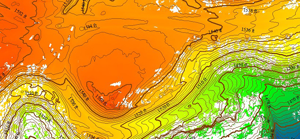
RTL-400 generated digital terrain model (DTM) overlaid with contour map. (Image: RedTail)
RedTail Lidar Systems is a division of 4D Tech Solutions Inc., a company focused on providing innovative technology-based solutions to address government and commercial customer needs. RedTail’s in-house technical expertise — coupled with a full suite of software and hardware design and manufacturing tools — allows the company to develop custom lidar solutions for manned and unmanned vehicle applications.
A point cloud is fundamentally a simple construct. It is a collection of points in 3D space, each point being given a coordinate in Cartesian convention. The points can also be given other properties, often these will be indicative of how they were obtained.
Examples might include the time at which they were “seen” by the surveying device that collected the data. The intensity or error in position that the point has might also be included.
Often point clouds will have around 100 million points after conducting a survey. Photography can also be overlaid on point clouds using photogrammetry techniques to essentially build 3D photography.
Image: OxTS
INS survey: point clouds
The principal method of collecting point-cloud data is by using lidar. Lidar technology is akin to radar: light is sent out from the device and bounces back off of objects. The difference is that radio uses large wavelength radio waves and lidar uses small wavelength lasers for high precision.
The time for light to return to the device is used with the speed of light to calculate the distance away. Typically, a lidar device will contain lasers with a fixed vertical angle, but which spin around in the horizontal plane. Internally, the device knows at what angle the laser is pointing vertically and its azimuth angle. This gives the device the position of the point on the object in 3D spherical coordinates.
The lasers inside produce thousands of points per second. Intensity, mentioned above, refers to the intensity of the reflected beam and indicates the reflectivity of the object.
What is a georeferenced point cloud?
Lidar requires navigation data to conduct a survey. We combine the navigation data with the lidar data to create georeferenced point clouds. Lidar devices know where points are in relation to each other, but they need to be told where they are in the world to be able to build a point cloud while moving the lidar.
The navigation data often comes from an inertial navigation system (INS). An INS is a sophisticated combiner of inertial measurement unit (IMU) and GNSS data to get the best navigation data — so a device knows where it is in the world and how it is moving.
The coordinates from the INS are added vectorially to the point coordinates of the lidar to get the final coordinates that would be used in the point cloud. This allows a user to put their lidar device on a vehicle like a van or an unmanned aerial vehicle (UAV) with an INS, to survey large areas efficiently instead of doing multiple static surveys and stitching them together.
Photo: OxTS
What are point clouds used for?
There are a wide range of applications for which point clouds can be used. They are increasingly used in real time for robots and autonomous driving computers to understand their environment and navigate through it. The data in a point clouds is convenient for recognizing and identifying surfaces and objects; for example, other cars, road signs and lane markings.
OxTS has been a global leader in inertial and GNSS technologies since 1998. OxTS is fundamentally involved in helping car manufacturers get the navigation data they require to go with lidar data in autonomous vehicle development, and in point clouds creation for use in surveying.
Distances and volumes are easy to calculate using point-cloud analysis software, and intensity can help identify different materials.
Another feature that lidar offers is multi-returns. This allows a laser pulse (which has a finite cross-section) to bounce back off of multiple surfaces to give multiple points from the same pulse. This is particularly useful for seeing windows and also seeing through them, and also for a myriad of other uses such as seeing the top of a treeline and the ground when flying over with a UAV.
It can also be used to see snow depth. The lidar can see the top layer of snow and also gets another strong return from the ground beneath.
At OxTS, we see lidar point clouds being used for driverless-car and work-vehicle development, coastal and forest management, infrastructure monitoring (signs, drains, bridges, road surfaces, railroads, etc.), creating 3D models of cities, pipeline exploration and more.
The final product is a simple file format, for which the possibilities are almost endless — and we see new applications using point clouds all the time.
The Federal Aviation Administration (FAA) plans to evaluate technologies and systems that could detect and mitigate potential safety risks posed by unmanned aircraft. The effort will be a part of the agency’s Airport Unmanned Aircraft Systems Detection and Mitigation Research Program.
The FAA Reauthorization Act of 2018 requires the agency to ensure that technologies used to detect or mitigate potential risks posed by unmanned aircraft do not interfere with safe airport operations.
The FAA plans to test and evaluate at least 10 technologies or systems. The evaluations are expected to begin later this year and will initially occur at the FAA’s William J. Hughes Technical Center, located next to the Atlantic City International Airport in New Jersey.
After the initial testing and evaluation in New Jersey, the agency expects to expand the effort to four additional U.S. airports. Those selections will be made at a later date.
According to the FAA, interested manufacturers, vendors and integrators of drone detection and/or mitigation technologies/systems will have 45 days to respond to its announcement.
In addition, the FAA expects to issue another solicitation in the coming weeks for airport operators interested in hosting the additional research and testing.
While connected cars provide wonderful advantages, their integration with cloud connectivity come with a heightened risk for cyber attacks.
Commentary by Alexander Meisel
When it comes to connected cars, automakers are innovating fast. Consumers are experiencing increasing amounts of futuristic features, be they passenger connectivity, automated speed regulation or autonomous driving capabilities.
However, these innovations and their integration with cloud connectivity come with a heightened risk for cyber attacks. A recent study conducted by U.K. self-driving hub organization Zenzic found that becoming cyber-resilient will be the biggest technical obstacle to successfully deploy self-driving cars on roads by 2030. This mountain will be a big one to surmount, and it’s only growing in size: The auto industry has seen a 94% year-over-year increase in hacks since 2016.
How can automakers prioritize security while keeping up with the demand for innovation in today’s connected cars?
Carmakers must consider security from day one
To make sure that security is built into the very foundations of a car, automakers must make it a priority from the first day of design. This focus is lacking amongst carmakers at the moment. In fact, 19% respondents to one survey said they don’t do enough security testing in the design phase, and only 28% said that they do a lot of the testing during the design stage.
Automakers can use design principles to build in security from the outset. For example, the principle of complete mediation allows for enhanced security as it ensures that a software stem “requires access checks to an object each time a subject requests access.” This means that attackers are only invited to exploit a system on one single occasion due to checks on subjects’ permissions.
Carmakers can also ensure that they are not sacrificing security by considering its importance when purchasing components from separate suppliers. These components must be specific enough to enable security in the system, but generic enough to allow for innovation.
Automakers must make cybersecurity a priority from the first day of design.
Here, companies can leverage the software engineering principle of interface segregation. This means that a shrunken, clear interface should be supplied by the vendor, so that the customer only uses the methods that are of interest to them.
In turn, this allows systems to remain decoupled and thus easier to then build a rich interface on top of. However, carmakers will have to stay on top of the security of the part in the development phase, and ensure that dormant functions are not abused by at least logging their execution once somebody tries to call them out of context.
Developers and cybersecurity experts must become a core part of the team
Software development is relatively new territory for carmakers. Now, cybersecurity is a key component of building connected cars, and automakers need to embrace developers that have expertise in this area and make them part of the core team.
This cultural change must be championed by the business leaders to allow car security to advance alongside the innovative features that the industry is building. This can be done by implementing DevSecOps ideology into the team, in order to “build the mindset that everyone is responsible for security.”
Car development teams will likely need a group of cybersecurity experts who can educate the rest of the developers and are willing to participate in the development process in order to check and implement safe and secure functions. If a company doesn’t have this kind of expertise in-house, they can partner with an expert third-party to help them along this journey.
Innovation and security can complement each other
Cybersecurity doesn’t mean sacrificing feature innovation: developments are being made in the field of security too, such as biometric technologies that can be integrated into car design.
For example, Blackberry’s QNX technology “has built in concepts for hardware and software trust validation, hypervisor to maintain a separation between the safety critical and infotainment systems, and a core operating system which passes all the functional safety standards,” according to the company’s senior VP SVP, head of QNX, John Wall. Innovation need not suffer at the hands of security, and vice-versa.
Potential AV thieves would first look to use GPS data to disable or falsify a car’s GPS system, making it untraceable.
In addition, the world’s leading electric vehicle provider, Tesla, ensures security in its cutting-edge, connected cars by sending security updates to cars’ operating systems overnight, and even providing awards for hackers that manage to hack its cars.
Looking ahead to the possibilities of autonomous vehicles (AV) that can drive passengers without needing to have their owner inside, innovation in GPS will be necessary to ensure security and accountability of the car. Potential AV thieves would first look to use GPS data to disable or falsify a car’s GPS system, making it untraceable.
However, carmakers can make this impossible for hackers by not just logging the data in its raw form, but also combining it with other car data using cryptographic algorithms. This ensures that the GPS data remains traceable even after the hardware has been taken apart and sold on the auto-parts black market. In this way, the signature of the original data combined with the GPS position adds an additional layer of security.
Integrating security into connected car design is no simple feat, but it’s a necessary one for carmakers that want to ensure the safety of their passengers while on the roads. By using design principles, diversifying expertise within development teams, and understanding that security and innovation need not be a trade-off, they can do just that.
Alexander Meisel is an automotive cybersecurity engineer at intive. He has a computer networking diploma from Hochschule Furtwangen University, and he has served as a CTO and Development Team Director in previous companies. He has experience with venture capital, successful M&As, and product and technical marketing strategies. He is also a public speaker at technical conferences and trade shows.
A roundup of recent products in the GNSS and inertial positioning industry from the September 2020 issue of GPS World magazine.
OEM
Inertial sensors
Includes four models
Photo: SGB Systems
The third-generation Ellipse series has a 64-bit architecture, allowing high-precision signal processing. All of the INS/GNSS devices now embed a dual-frequency, quad-constellation GNSS receiver for centimetric position and higher orientation accuracy. The Ellipse-A is a motion sensor; Ellipse-E provides navigation with an external GNSS receiver; Ellipse-N is a single-antenna RTK GNSS/INS; and Ellipse-D is a dual-antenna RTK GNSS/INS. With its new 64-bit architecture, the third-generation Ellipse series enables the use of high-precision algorithms and technology used in high-end inertial systems such as rejection filters and FIR filtering.
The PNT-6220 Assured Reference combines low-Earth-orbit (LEO) signals, GNSS, terrestrial, wireline and atomic clock services in one small solution for critical infrastructure applications. The PNT-6220 seamlessly combines concurrent L1, L2, L3 and L5 GNSS reception with a LEO-based Satellite Time and Location (STL) timing receiver. It also includes terrestrial receivers and PTP/IEEE-1588 edge grandmaster and PTP/IEEE-1588-slave capability. It provides assured PNT for critical infrastructure applications such as those described in the directives of Presidential Executive Order 13905. It can serve as a timing reference for 5G equipment, an ePRTC-capable reference, or a high-performance disciplined reference that supports PTP/IEEE-1588, STL, RF distribution and multi-frequency GNSS capability. The PNT-6220 can automatically select the most optimal UTC reference input and switch over among its numerous reference inputs if one or more are jammed or spoofed, as well as average several references for additional stability and accuracy.
Jackson Labs Technologies, jackson-labs.com
GNSS Receiver
Integrates correction service
Photo: Septentrio
The AsteRx-m2 Sx OEM board provides a GPS/GNSS receiver with always-on sub-decimeter accuracy without the need for additional correction service subscriptions. GNSS corrections are automatically streamed to the receiver. The integration enables plug-and-play positioning with high accuracy available out of the box. The AsteRx-m2 Sx is an efficient positioning solution for small robots, aerial drones and automation applications. Advanced anti-jamming technology AIM+ ensures robust and reliable operation in challenging environments, even in the presence of RF interference.
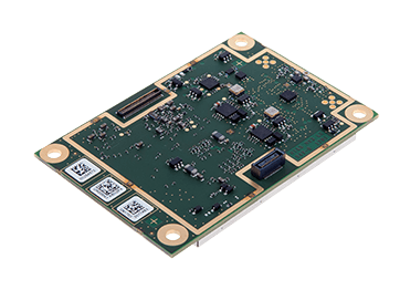
The xOEM v3 inertial navigation system includes the architecture from the company’s IP65-encased xNAV v3 as well as a full range of software interfaces, providing integrators maximum configuration flexibility, real-time monitoring, post-processing and analysis. Software interfaces can be customized using the OxTS NAVsuite. Plugins can be created using the company’s NAVsdk, allowing the xOEM v3’s software to be easily packaged and included as part of a product.The high-grade MEMS inertial sensors and real-time kinematic (RTK)-capable GNSS receiver within the xOEM v3 board set deliver high performance capabilities. The board set provides 0.1° heading accuracy, 0.05° pitch/roll accuracy and 2 cm global position accuracy. The board set is compact at 150 grams, which enables manufacturers to seamlessly integrate and build a high-performance INS into their products, such as commercial mapping applications on land and in the air. Its light weight means more payload capacity for other critical components. An add-on lidar georeferencing software package is also available with a sophisticated boresight calibration tool.
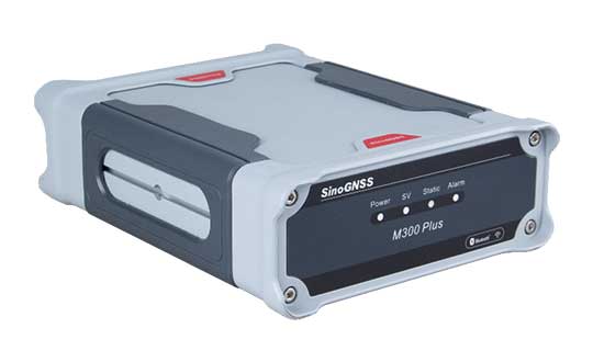
The M300 Plus GNSS receiver is designed to supplement the company’s M300 Pro, which is aimed at clients who need a more economical version for their CORS networks. The M300 Plus is also designed for monitoring projects and other applications. By using a powerful, adaptive detecting and canceling technology, the M300 Plus provides enhanced anti-jamming capability, which is critical for a reference station providing reliable GNSS data. Its built-in web server provides remote control of receiver configuration, status, firmware update and data download. It uses a 4G module as an internet backup, enhancing the stability of data connections.
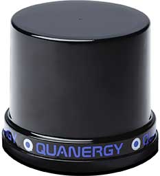
The MQ-8 family — 3D lidar sensors and perception software — are part of Quanergy’s Flow Management platform. Designed with a new smart beam configuration, the MQ-8 solution delivers up to 140 meters of continuous tracking range, enabling up to 15,000 m2 of coverage with a single sensor. It is suitable for flow management applications such as security, smart city, social distancing and smart space industries.
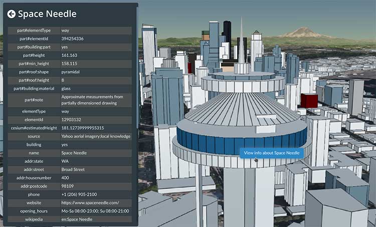
Cesium OSM Buildings expands the company’s suite of Global Base Layers including worldwide terrain, aerial imagery and streetmaps already available. With the new layer, 3D buildings can be visualized, styled and analyzed in an efficient and interoperable manner using 3D Tiles, the open standard developed by Cesium to stream massive 3D geospatial datasets. The layer gives geospatial developers urban context to 3D applications. The buildings are created for efficient visualization and are streamable to any device with 3D Tiles.Cesium OSM Buildings are derived from OpenStreetMap. Buildings are also regularly updated, firmly clamped to terrain, and individually selectable and styleable.
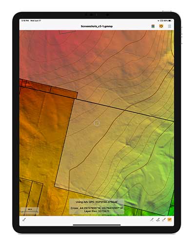
Version 2.1 of Global Mapper Mobile provides updates to both the free and Pro versions. The iOS and Android applications are designed for viewing and collecting GIS data, and provide situational awareness and location intelligence for remote mapping projects. A complement to the desktop version, the mobile app can display all supported vector, raster and elevation data formats. The release improves vector feature styling, terrain layer support and layer transparency setting. In the Pro version, it introduces advanced GPS support, allowing users to connect to external, high-accuracy Bluetooth GPS devices from vendors such as Eos Positioning and Bad Elf. It also allows access to detailed information including the satellite constellation, precise location information and the raw NMEA stream.
The AiRXOS Enterprise Energy Solution provides digital compliance, situational awareness of airspace and assets, inspection, emergency response/disaster recovery capabilities, analytics and asset performance tools in a connected platform. It runs on AiRXOS’ Air Mobility Platform — a secure, cloud-based, extensible platform that enables integration of an energy organization’s current applications and other UAS service suppliers. It brings all UAS lifecycle operations into one view, including infrastructure inspection, asset and crew management, and emergency operations after a natural disaster.
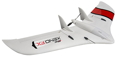
The Xeno FX is a fixed-wing platform optimized for efficient and cost-effective area survey and monitoring missions. Users can program the flight plan before launch to ensure thorough coverage of a target region. The fixed-wing design allows for efficient cruise and maximum time aloft. The Safe Launch protective feature means the propeller starts spinning only after the airframe has been safely hand launched. A quick-change modular payload system allows users to reconfigure their data-acquisition hardware for multiple missions. Constructed of Multiplex’s resilient Elapor foam, the folding wings make for compact storage and easy transport.
A recently unclassified CIA drone program provides us with perspective on UAS development. Also, U.S. high-altitude surveillance capabilities are being tested, another record has been achieved, and an award for the U.S. Air Force space plane.
1960s CIA Bird-Drone
Back when the U.S. was flying U2 spy planes over the Soviet Union and Gary Powers was on Russian TV after being shot down, the CIA got to thinking of another approach for gathering airborne intelligence.
Project Aquiline was an early drone project aimed at making overflight much less conspicuous — because the drone was built to resemble a bird.
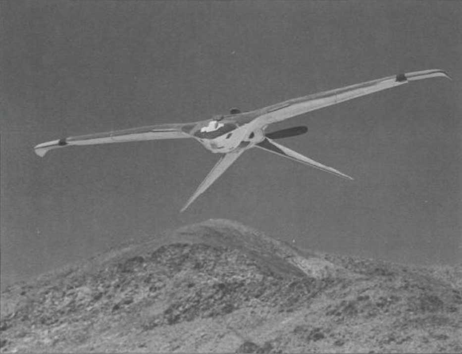
Project Aquiline was contracted to McDonnell Douglas, which produced five prototypes. (Photo: CIA Archives)The Project Aquiline bird drone in flight. (Photo: CIA Archives)
With a two-stroke engine driving a pusher-propeller and an 8-foot wingspan, five prototypes were built and tested through 1967-68. The concept was to fly at lower altitudes than the U2, carrying equivalent camera and electronic surveillance equipment, but to be very difficult to observe from the ground.
Although a two-stroke engine might have been somewhat noisier than a large bird, later phases of the program envisaged a miniature nuclear power source which presumably would have been much quieter with a relatively huge range.
The project began in 1966, and prototypes began operational testing in 1968. The prototypes established a range of around 130 miles, took high-resolution images and successfully returned to the control site.
However, with many stages of development still to go (the cost to complete was maybe too high), the project was canned in November 1971.
Maybe this initial “bird” concept is where the name of today’s high-altitude, long-endurance Global Hawk drone originated — who knows?
NASA High-Altitude Long-Endurance (HALE) UAVs
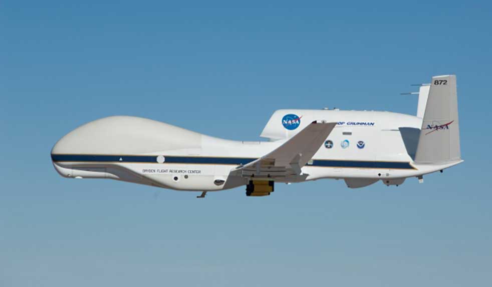
But the U.S. government seems to have other objectives than just high-altitude reconnaissance. NASA has operated the Global Hawk drone for science missions for a number of years, alongside the U-2 and ER-2 high-altitude manned aircraft.
Armstrong Flight Research Center operates two Global Hawks with support from Northrop Grumman out of Edwards Air Force Base.
Global Hawk is flown with a pre-loaded mission profile at upwards of 60,000 feet, sometimes for as long as 24 hours and more than 8,000 miles. Nevertheless, the aircraft is monitored over both satellite and terrestrial links, with direct sensor payload access throughout.
The Global Hawk. (Photo: NASA)
Global Hawk is powered by a Rolls-Royce AE3007H turbofan engine. It has a wingspan exceeding 116 feet, measures 44 feet from nose to tail, has a gross takeoff weight of 25,250 pounds and carries a 1,500-pound payload.
But this aircraft is massive compared to another recent high-flying project that NASA funded through a Phase I and II Small Business Innovation Research/Technology Transfer (SBIR/SBTT) program.
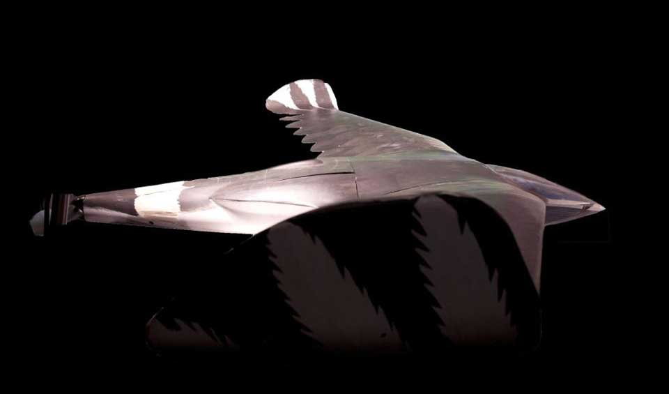
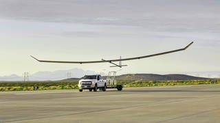
The Swift HALE unmanned aircraft system (Photo: Swift Engineering/NASA)
With the help of NASA’s Ames Research Center, Swift Engineering in San Clemente, California, completed a two-hour flight test on July 7 of its High-Altitude Long-Endurance (HALE) UAS, aiming to join the group of companies already in the high-altitude UAV club.
The 72-foot wingspan, solar-powered HALE weighs <180 pounds, carries a 10-15-pound payload and is destined to fly at up to 70,000 feet for more than 30 days.
This HALE aircraft is expected to complement existing NASA observation platforms and provide unique material alongside existing satellite data. Swift Engineering has been working with NASA Ames since 2016 on a proof-of-concept solar-powered UAS aimed at sustained flight for a month or more.
Swift researched solar panels and high-power, multiple-cycle rechargeable battery technologies to develop a system that could survive harsh temperatures as well as the radiation encountered at high altitude.
During the first of a series of flight tests at Spaceport America in New Mexico on July 7, operations at low altitude were completed to verify systems, aerodynamic control and power-system models. The July 7 flight was the first in a series to collect data and further validate the design.
With NASA, Swift has developed a UAS to not only meet observation objectives, but also one that aligns with the Federal Aviation Administration’s view of HALE deployment and maintenance during extended flights. For the test flight, the vehicle carried a NASA FluidCam for science missions, with a focus on mapping coastal reef systems.
NASA teams are exploring how aircraft such as Swift’s could perform as pseudo-satellites for air-quality monitoring, image coastal zones, map landslides and geologically active regions, and for real-time forestry and agricultural monitoring.
The next step in the development is expected to be a Phase III series of scientific observations at high altitude for days and even weeks.
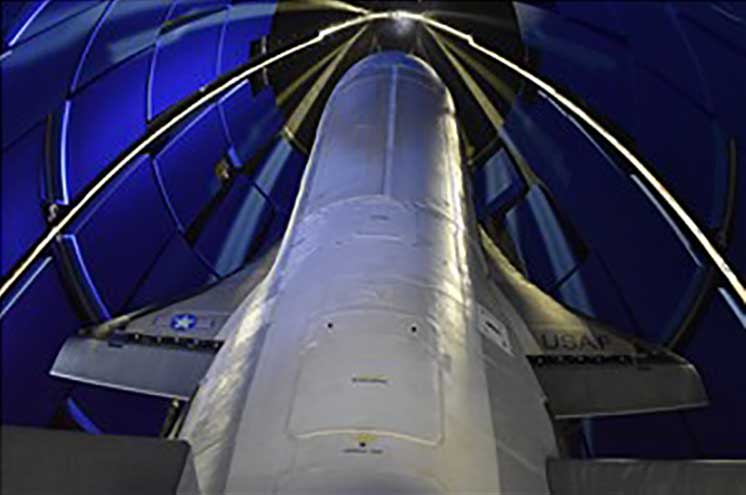
Boeing X-37B Team Wins Collier Trophy
The Air Force/Boeing X-37B autonomous space plane has won the Collier Trophy for best in U.S. aeronautics/astronautics performance and safety in 2019.
The X-37B set a new 780-day on-orbit record and descended through the controlled U..S National Airspace System (NAS) to land at NASA’s Kennedy Space Center.
Initially launched in 2010, the reliable, reusable and unmanned X-37B has provided space access and subsequent analysis for a large number of key experiments.
The Air Force/Boeing X-37B autonomous space plane has won the Collier Trophy. (Photo: USAF/Boeing)
The space plane has now broken its previous on-orbit record of 718 days and has orbited for 2,865 days and more than 1 billion miles in total. Originally designed for only 270 days in space, the X-37B has established endurance records in every one of its last five flights.
Since 1911, recipients of the Collier Trophy have included Orville Wright, the Apollo 11 lunar landing team, the International Space Station team, the U.S. Navy F/A-18E/F Super Hornet team and the Boeing 787, 777 and 747 passenger aircraft teams.
Intelligence Gathering
News about the 1960 CIA drone developments, aimed at gathering unobserved photo reconnaissance intelligence, provide new perspective on NASA’s current-day use of high-altitude observation assets. These are the same types of assets that the U.S. currently uses for intelligence gathering, despite being recently intercepted by Russian jets off the coast of Alaska. It makes for interesting aspects of drone history, along with new aspects of (very) high-altitude unmanned capabilities.
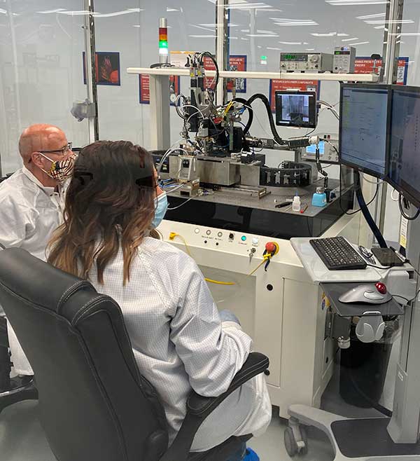
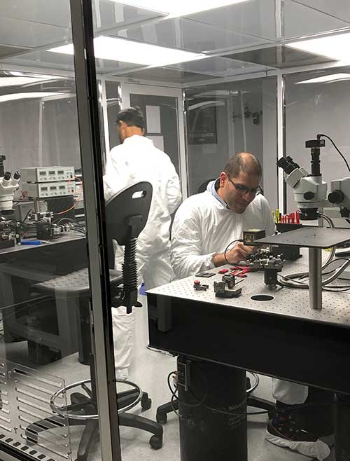
KVH photonics engineers test PICs for validation prior to production. (Photo: KVH)
In June, KVH Industries launched the P-1775 inertial measurement unit (IMU), featuring its new PIC Inside photonic integrated chip (PIC) technology.
After developing and testing the technology for more than three years, the company began incorporating it into existing product lines and has shipped the first units.
The PIC technology features an integrated planar optical chip that replaces individual fiber-optic components to simplify production while maintaining or improving accuracy and performance.
The product is designed to deliver 20 times higher accuracy than less expensive micro-electromechanical systems (MEMS) IMUs. It uses modular designs for ease of integration and has outstanding repeatability unit-to-unit, according to the company.
KVH will add the technology to its inertial sensor product line for use across a broad range of applications, from navigation to stabilization and pointing.
KVH’s fiber-optic gyros (FOGs) and FOG-based products are particularly well-suited for the large and growing autonomous market, which includes applications on land, sea and air, such as drones, people movers, trucks and mining and construction equipment.
Moving Components to the Chip
Photo:With PIC technology, KVH’s FOG production process incorporates machine automation for photonics assembly. (Photo: KVH)
The controls on FOGs have an electronics portion and an optics portion. The latter consists of a light source, a detector, couplers, polarizers, a coil (which performs the sensing), and a piezoelectric device for modulating the light, explained Robert Balog, KVH’s chief technology officer.
Until now, the company had fabricated all the products for that optical circuit in its Chicago facility, in a process that was labor-intensive and required much process control. For the PIC, “We’ve taken the couplers and the polarizer sections specifically and moved them onto the chip level,” Balog said.
While KVH manufactures the chip much like any other semiconductor device, rather than passing the light through the fiber KVH is now passing it through wave guides that are contained within that photonics chip, thereby moving the creation of the coupler module into a wafer-level component.
Mass Production and Better Quality
KVH produces the chips en masse on a wafer, then singulates and samples them. Once they are qualified and spot-checked, the chips are incorporated into KVH products.
“This affords us a way to mass produce those components,” Balog said, “and gives us much better quality.”
Photo: KVH
Additionally, it produces a much smaller device than before. The company will not reveal any numbers regarding its performance improvement until it produces and distributes more PICs, but “it is already producing better results than the manually produced components.”
The production process is intimately linked to the overall performance of the sensor. “The tighter your process control, the more reliable you can make the product,” Balog said.
The new process also improves the device’s field reliability because it contains fewer discreet components. The improved performance specifications on each individual FOG improve the overall performance of the IMU or the inertial navigation system (INS) because the bias is more stable and repeatable.
The Future
What is in the technology’s future?
“The next step is integrating the light source and the detector and potentially a modulator into that chip as well,” Balog said. “So, our ultimate technology road map is to continue condensing what would have been discrete components in traditional gyros all within that chip. As this technology progresses, it will get smaller, tighter, and better. Then you will see big leaps in performance.”
Tallysman Wireless has added a line of AccuAuto vehicle antennas aimed at the autonomous vehicle market.
The compact and rugged embedded AccuAuto antennas offer key features not available in other embedded autonomous vehicles antennas on the market, the company said.
The automobile industry is transitioning from offering GNSS-assisted navigation where the accuracy requirement is ±3 to 5 meters (low-precision GNSS code positioning) to providing driver assistance (such as lane-keeping) and autonomous vehicle navigation where the accuracy requirement is < 0.1 meters (such as high-precision GNSS phase positioning).
Current roof-mounted GNSS antennas on most vehicles provide the accuracy required for navigation but they lack the precision required for assisted driving or autonomous vehicle operation. Tallysman’s new line of AccuAuto antennas are designed to provide strong clean code and phase signals that enable high-precision real-time kinematic (RTK) and precise point positioning (PPP) navigation.
The Tallysman embedded AccuAuto vehicle antenna features a patented Tallysman Accutenna technology multi-constellation and multi-frequency antenna element, an integrated ground plane, radome and underside cover that provides mist and condensation protection.
The bottom cover also supports the antenna cable and mitigates cable vibration to ensure the antenna has a long service life, while the ground plane improves antenna performance.
All AccuAuto antenna electronic components are Automotive Electronics Council (AEC) certified and are designed to perform under challenging environmental conditions, such as extreme temperatures (–40 °C to +125 °C) and continuous shock and vibration.
Signal quality is improved with a deep pre-filter that minimizes out-of-band noise and maximizes in-band reception. This feature enables reliable GNSS signal reception in challenging urban environments, where inter-modulated signal interference from LTE and other cellular bands is common.
The triple-band TWA928 supports GPS/QZSS-L1/L2/L5, GLONASS-G1/G2/G3, Galileo-E1/E5a/E5b, BeiDou-B1/B2/B2a, and NavIC-L5 signals and frequency bands (the TWA928L includes support for L-band correction services).
Using RTK’s pinpoint-level location data in the Verizon network is a building block to bring to scale emerging technologies such as driverless city zones, expansion of precision agriculture and drone delivery.
Verizon has launched what it calls hyper-precise location using real-time kinematics (RTK) to provide accuracy within one to two centimeters on the Verizon network.
Verizon has built and deployed RTK reference stations nationwide so that compatible internet of things (IoT) devices can receive the higher accuracy. Verizon is working to make RTK accessible with myriad device makers.
RTK will also support emerging technologies that depend on high-level location accuracy, such as delivery drones and customer-approved location data for first responders in emergencies.
RTK technology reduces the cost and risk associated with inaccurate location data, Verizon said in a press release. “Billions of IoT devices across a multitude of industries will benefit from improved location accuracy, with hyper-precise location information enabling a host of new services.
“For instance, robotics at distribution centers will be able to perform more efficient, accurate and safe logistics operations. More accurate positioning can help speed deployment of high-value assets in emergency situations to the precise location, and more precise tracking of emergency equipment can provide faster redeployment in disaster response scenarios.”
The rollout of its hyper-precise location services along with Verizon’s 5G Ultra Wideband network and 5G Edge will pave the way for more autonomous technologies, the company said.
“We are scaling RTK to enable mobile location accuracy to within a few centimeters, transforming what is currently possible when it comes to location-enabled services and new IoT solutions coming onto the market,” said Nicola Palmer, chief product development officer for Verizon. “Continued growth in the IoT environment means billions of devices in fields where precision location services are becoming more critical, such as vehicle automation, unmanned aerial vehicles, precision agriculture technology, infrastructure monitoring, asset tracking and high-value shipping.”
Image: 4X-image iStock / Getty Images Plus / Getty Images
Reimagining road safety
In partnership with HERE Technologies, Verizon is building next-generation technologies for vehicle and pedestrian safety using hyper-precise high-definition mapping and RTK.
This work paves the way for connected services that are designed to drive road safety improvements. By creating a vehicle-to-network (V2N) communication system equipped with hyper-local location accuracy, collision avoidance applications can precisely identify vehicles, pedestrians and bicycles, and relay the information through Verizon’s 5G Edge and HERE’s AI to predict likely travel paths and warn vehicles of impending potential collisions. This partnership is one of multiple recent initiatives Verizon has taken to increase road safety.
“Moving beyond the static fidelity of satellite-based location data enables an exciting new generation of connected, autonomous experiences,” said Jørgen Behrens, SVP, chief product officer at HERE Technologies. “By pairing HERE’s live, hyper-precise HD Map and HD Positioning technologies with intelligent RTK algorithms, and making that scalable, Verizon is putting a transformative level of location insights into the hands of developers and consumers alike.”
Powering the autonomous future
Hyper-precise location accuracy will be critical to advancing autonomous driving and together, Verizon and Renovo are ushering in a new era of transformative solutions critical for the future of autonomy on the road. These solutions leverage machine learning and RTK technology, powered by a combination of next-generation solutions such as 5G.
“RTK is a critical technology for advanced driving assistance systems (ADAS). Accurate positioning helps ADAS vehicles navigate better, drive smoother, and react faster to the surrounding environment,” said Christopher Heiser, CEO and Co-Founder of Renovo. “Nationwide, reliable RTK networks make for a viable way to deliver these enhanced capabilities to mass-market cars and trucks. For companies that manage the huge datasets that power next-generation vehicle platforms like Renovo, this is very exciting.”
IoT devices currently using RTK can be accessed and managed through Verizon’s ThingSpace management platform and APIs.
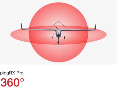
uAvionix has announced pingRX Pro, a detect-and-avoid ADS-B receiver for professional unmanned aircraft systems (UAS). PingRX Pro is expected to be available in the fourth quarter of this year.
pingRX Pro detects private and commercial aircraft operating on 978 MHz and 1090 MHz. The received aircraft’s identity, position and altitude are visualized on a moving map in real time, allowing the UAS operator or autopilot to remain well clear.
The new pingRX Pro continues uAvionix’s lineage of easy to integrate receivers with direct support for popular Ardupilot-based autopilot systems. By adding the protection of an aircraft-grade aluminum case and detachable remote mount antenna, pingRX Pro provides an ADS-B receiver for professional UAS operators who need performance, quality and flexibility for limitless UAS applications.
“UAvionix has led the way in ADS-B solutions for unmanned aircraft since our founding.” said Christian Ramsey, president of uAvionix. “Industry leaders and BVLOS operators continually choose ADS-B receivers as their primary detect-and-avoid solution. pingRX Pro now offers manufacturers and integrators the installation flexibility they need for their enterprise aircraft. ”
Weighing less than 8 grams, pingRX Pro features uAvionix ping ADS-B, proven in over a half-million ADS-B solutions worldwide, from UAS to airport vehicles to certified general aviation solutions.
PingRX Pro offers an external antenna, allowing operators to install it anywhere on the airframe. UAS are often designed from materials that can block radio frequencies and impair radio performance. By providing an external remote mounted antenna, performance can be maximized while providing critical protection of the receiver mounted inside the fuselage.
ADS-B Out
Diagram: uAvionix
ADS-B uses precision GPS information to broadcast the position of an aircraft in real time. The technology allows aircraft to share the skies more efficiently by telling each other where they are.
With ADS-B already widely adopted by manned aircraft, the task of detect and avoid is eased because the manned aircraft are broadcasting their position directly to the drone operator with no intermediary. While many aircraft not yet equipped with ADS-B OUT, nearly all large commercial operators are equipped.
The United States requires ADS-B OUT on all manned aircraft with an engine-driven electrical system operating near medium and large cities from the surface to 4,000 feet above ground.
Given the likelihood of ADS-B OUT on manned aircraft, and the density in these prime areas for inspection and package delivery, pingRX Pro ADS-B IN enables drone operators to meet their requirement to remain well clear of surrounding aircraft.
PingRX Pro tracks 100 simultaneous aircraft at ranges exceeding 150 miles, all at nearly 200% less power consumption of the alternatives.
The Federal Aviation Administration (FAA) has awarded $3.3 million in research, education and training grants to universities that comprise the FAA’s Air Transportation Center of Excellence (COE) for Unmanned Aircraft Systems, also known as the Alliance for System Safety of UAS through Research Excellence (ASSURE).
“These grants will help develop a greater array of innovative strategies to more effectively deploy drones during emergency response situations,” said U.S. Transportation Secretary Elaine Chao.
The FAA’s CEO program, authorized by Congress, is a long-term, cost-sharing partnership between academia, industry and government. The program enables the FAA to work with center members and affiliates to conduct research in airspace and airport planning and design, environment and aviation safety, FAA said.
Mississippi State University received the Alliance for System Safety of UAS through ASSURE Program Management grant for $1,290,410. This grant is for the ASSURE lead university to provide overall program management. This program management will include tracking of financial information for all core university project activities; reviewing and vetting of all project related documentation prior to submission to the FAA; hosting and facilitating all FAA-required meetings; and outreach to government, industry and academia, FAA said.
Six universities, including the University of Alabama–Huntsville ($1,101,000), New Mexico State University ($234,000), the University of Alaska, Fairbanks ($245,000), Mississippi State University ($130,000), North Carolina State University ($124,979) and Oregon State University ($165,000) received grants for Disaster Preparedness and Response (Phase I and II, as directed by Congress). According to FAA, this research will provide insight into the safe integration of UAS into the disaster preparedness and response areas. This research will look at how UAS can aid in disaster preparedness and response to different natural and human-made disasters. It will focus on procedures to coordinate with the Department of Interior, the Department of Homeland Security, the Federal Emergency Management Agency and other federal, local and state organizations to ensure proper coordination during those emergencies.
There are currently 1.65 million recreational and commercial drones in the active UAS fleet. That number is expected to grow to as high as 2.31 million by 2024, FAA reported. The ASSURE grants are aimed at continuing the safe and successful integration of drones into the nation’s airspace.
“Collaboration is hugely important as we work to safely integrate UAS into the aerospace system,” said FAA Administrator Steve Dickson. “These important grants fund the research which allows us to learn and implement the safety measures associated with UAS operations in the airspace.”
The COE universities received a total of $3.3 million to advance specific goals and projects. This is the second round of ASSURE grants. The grants listed above will bring the fiscal year 2020 total for this COE to $5.8 million.