Team to provide all-in-one hardware and software platform for commercial drones.
GE Aviation and Auterion are integrating the Auterion Enterprise PX4 operating system on GE Aviation’s Unmanned Aircraft System avionics platform.
The companies signed a teaming agreement to provide a comprehensive hardware and software solution for drone manufacturers and operators seeking to enable commercial drone operations at scale.
The hardware and software platform is designed with commercial vehicle original equipment manufacturers (OEMs) and service providers in mind. It is being displayed at Auterion’s booth (#2009) at AUVSI Xponential, taking place this week in Chicago.
The teaming enables a full-stack solution with airborne autopilot and application computing hardware, flight management, safety management and integration. GE Aviation is providing the avionics hardware, application computing, flight management and integration into airframes. Auterion is providing Enterprise PX4, the operating system that runs on the vehicle, in the cloud and the ground station.
The core architecture of the hardware and software platform has been implemented with the objective of supporting developers through global open software standards while maintaining an independent and authoritative safety controller.
The combination of the two supports long-term flexibility and a high level of design assurance to enable commercial drone operations beyond visual line of sight (BVLOS) and within complex airspace and obstacle environments.
Flight testing of the hardware and software platform took place over the last three weeks at Reno-Stead airport in Reno, Nevada.
“In demonstrating a seamless integration of ground, cloud and airborne components, we’ve reached another milestone in helping to unlock the value in autonomous and UAS advanced operations,” said Alan Caslavka, president of Avionics Systems for GE Aviation. “Auterion’s open standards leadership and cooperative legacy with the developer community is the foundation to scale a sustainable solution critical for commercial drones.”
“We are excited about the collaboration with GE Aviation that allows us to offer our operating system on high reliability hardware to meet future regulations,” said Kevin Sartori, Co-Founder of Auterion. “With this collaboration, the combined solution will significantly reduce barriers commercial cargo drones face flying in manned airspace or inspection drones to flying in urban areas.”
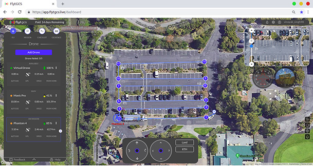
FlytBase Inc., an enterprise drone automation company, has launched of FlytGCS, a cloud-based remote drone operations solution, at AUVSI Xponential 2019.
FlytGCS is built for subject matter experts, drone operations managers and UAV operators who wish to automate, simplify and scale their missions. At its core is beyond-visual-line-of-sight (BVLOS) operations.
Photo: FlytBase
To support the execution of automated BVLOS missions, FlytGCS offers a wide range of features including connectivity and control over 4G/LTE/5G, live high-definition video feed, fleet management, unlimited missions and unlimited drone addition, remote gimbal control, pre-flight checklist and geofence, mission planner and cockpit view from a web dashboard.
FlytGCS is a hardware-agnostic solution that helps securely deploy industry-standard drones over the cloud, for BVLOS operations, using a mobile app (for DJI drones) or onboard SBCs (for Ardupilot and PX4 drones).
Add-ons such as precision landing, fleet management, pilot team management and drone-in-a-box make FlytGCS a powerful, affordable and scalable alternative to traditional, expensive, desktop-based GCS products, the company said.
According to FlytBase, UAVs will create significant business value as soon as drone fleets can fly BVLOS. Technologists, regulators, business executives and drone operators all expect the industry to progress towards remote, autonomous, cloud-based drone operations across geographies, sectors and use-cases.
Photo: FlytBase
“With FlytGCS, the power of autonomy is made available to drone operators, subject matter experts and service providers who can now seamlessly manage drones over 4G/5G networks, with best-in-class latency and live video quality,” said Nitin Gupta, FlytBase CEO. “As a SaaS product, this FlytBase offering helps our customers get started immediately, for free, and upgrade to the feature set that is best suited for their business needs. Operators have used FlytGCS in applications ranging from construction management and security/surveillance operations to emergency response and utility/asset inspections.”
The Ohio Unmanned Aircraft Systems Center and the Air Force Research Laboratory (AFRL) will soon begin testing groundbreaking aviation technology at the Springfield-Beckley Municipal Airport.
Ohio Governor Mike DeWine, Lt. Governor Jon Husted and Major General William Cooley, commander of the Air Force Research Laboratory (AFRL) made the announcement April 26 at Wright Patterson Air Force Base.
Skyvision was developed in a collaboration between AFRL and the State of Ohio. AFRL and a delegation of Ohio UAS industry experts will showcase the SkyVision system at AUVSI Xponential in Chicago April 30 to May 2 (Booth 4226).
The SkyVision technology safely, accurately and effectively allows drones to detect and avoid other aircraft while in flight. SkyVision can be described as an air traffic control system for drones.
Inside the Skyvision RV. (Photo: Ohio UAS Center)
The validation of this aviation technology led the FAA to grant AFRL a certificate of authorization to test defense-related drone technology without reliance on a visual observer or chase aircraft.
Typically, drones can only fly within the uninterrupted line of sight of the person operating the UAS, but this special waiver allows AFRL and the Ohio UAS Center, which is part of the Ohio Department of Transportation’s DriveOhio Initiative, to use SkyVision to test drones beyond the visual line of sight (BVLOS) within a 200-square-mile parcel of unrestricted airspace near the Springfield-Beckley Municipal Airport.
“As our country steps more and more into the unmanned age of flight, this technology is on the forefront of the aviation frontier, making Ohio a critical national asset for the research and development of UAS technology,” said Governor DeWine. “This also opens the door for commercial companies to work with Ohio, AFRL, and the FAA to test their own UAS-related
technology using our SkyVision detection system. This is a major step in revolutionizing the transportation industry, with Ohio leading the way in aerospace, defense, and aviation innovation.”
“This is an important development in the progression of unmanned aircraft,” said Major General William Cooley, Commander of AFRL at Wright-Patterson Air Force Base. “This waiver provides the latitude to test beyond-line-of-sight keeping AFRL on the leading edge of world-class research and accelerates the delivery of technology that makes a difference to the warfighter.”
“By enabling our lower-altitude airspace for advanced modes of transportation, we’ll be able to facilitate new opportunities around advanced autonomous aircraft research and development,” said Lt. Governor Husted. “This will bring investment to Ohio and solidifies Ohio’s position as a world- recognized leader in aviation technology.”
Ohio’s SkyVision detection system could potentially be used by the state to develop and test UAS technology to assist citizens in the event of a natural disaster or to significantly enhance the capability of search and rescue teams to find missing persons in time-critical situations. Commercial companies, such as those looking to use drones to survey damaged infrastructure or hoping to launch drone commerce operations, will also now have incentive to move to Ohio to test their own UAS technology.
VyrtX, a company based out of Dayton, is among the first companies that has committed to expand into Springfield to work with AFRL and the Ohio UAS Center. VyrtX is currently developing technology for the potential transport of organ donations between hospitals for transplant surgeries.
UAS test flights will take place at heights ranging from 1,000 feet above ground to 10,000 feet mean sea level. Air traffic control experts from the Ohio UAS Center will operate SkyVision during each flight. The SkyVision detection system is located within a mobile unit so that it can be flexibly placed in optimum positions for each flight.
“Today’s announcement comes after years of hard work and collaboration among an incredible group of partners,” said Jeff Hoagland, President and CEO of the Dayton Development Coalition. “AFRL and Ohio had a bold vision to bring UAS into the national airspace for true beyond-visual- line-of-sight flight. The work done here will shape the industry for years to come.”
The State of Ohio and AFRL both invested a combined $5 million for the research and development of SkyVision.
Supported by the Ohio Department of Transportation, DriveOhio works to ensure Ohio’s regulatory environment and public policies are conducive to the development of the infrastructure and technologies needed for smart mobility.
Deseret UAS unveils premier test facilities and technologies from Utah-based companies.
Deseret UAS will be exhibiting at AUVSI Xponential, offering commercial unmanned aerial systems (UAS)/urban air mobility (UAM) flight test facilities.
Deseret UAS headquarters is located at the Xperience Center in Tooele City. (Photo: Deseret UAS)
Deseret UAS offers access to wide-open land and airspace, as well as the necessary Federal Aviation Administration (FAA) authorizations for large commercial UAVs and UAM aircraft.
The organization’s commercial flight test amenities include a 4,500-foot paved runway with a covered airplane hangar, mobile test units, certified Part 107 pilots, data analytics, beyond visual line of sight (BVLOS) test capabilities and state-of-the-art training facilities.
“We encourage all Xponential attendees to visit our booth and see firsthand the cutting-edge technologies being developed right here in Utah,” said Deseret UAS Board Chair Shawn Milne. “The unique assets we offer at an affordable cost have been a game-changer for companies seeking to operationalize their technologies.”
The Utah Pavilion will also have Utah-based companies exhibiting their prototypes that have the potential to revolutionize mobility, safety, and security.
Founded in 2017, ElectraFly is an aviation company building a hybrid-electric personal flying vehicle. It aims to increase lift capacity and flight times for vertical take-off and landing aircraft and is positioned between a personal jetpack and a large, helicopter-like air taxi.
The ElectraFly prototype is being built to carry a rider — something ideal for first responders or military special forces. Other versions will be scaled for air taxi or search and rescue, and smaller versions will be ideal for shipping and package delivery.
“There is an undeniable change happening in air transportation but there are problems in efficiency,” said John Manning, ElectraFly co-founder and director of development. “So many people, especially as children, dream about flying. We’re developing innovations to make the dream of personal flight a reality and to shape the future of urban air mobility.”
Fortem Technologies is an innovator in airspace safety and security. Fortem’s AI-enabled SkyDome software and TrueView radar digitize airspace, making it possible to ensure safe urban corridors and to protect infrastructure, venues, borders and cities against rogue drones. This digitization can make drone package delivery and the safe transport of people a reality.
“Safe air mobility of unmanned drones flying beyond visual line of sight is achievable,” said Fortem CEO Timothy Bean. “Fortem Technologies makes this possible by digitizing the airspace so that cooperative and non-cooperative air traffic can be differentiated, assessed for threats, and managed for safety of our airways.”
Also exhibiting at the Utah Pavilion will be officials from the Governor’s Office of Economic Development (GOED) and the Economic Development Corporation of Utah (EDCU). GOED and EDCU will be available to answer questions about economic development opportunities in the state.
“Utah has always been at the forefront of technological innovations that improve lives and the state’s investment in Deseret UAS is evidence of that,” said Ginger Chinn, managing director of Urban and Rural Business Services for the Utah’s Governor’s Office of Economic Development. “We whole-heartedly embrace unmanned aircraft technologies and are proactively developing a plan to build the aerial infrastructure needed for these innovations to flourish.”
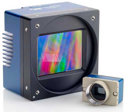
Teledyne Optech, Teledyne DALSA and Teledyne Scientific & Imaging, all part of the Teledyne Imaging group, will share a combined presence at Booth #2520 at the AUVSI Xponential 2019 show in Chicago April 29-May 2.
The three companies will showcase their new and advanced sensor and imaging solutions.
Teledyne Optech presents a new compact lidar family, the CL-90. Attendees can preview the lightweight, compact lidar platform for UAV deployment. The CL-90 features exceptional canopy penetration, offering the low-noise, high-quality survey-grade data to deliver extraordinary performance in data accuracy and point precision.
The CL-90 empowers full lidar performance across the entire operating altitude range of the UAV, and offers an exclusive variable field-of-view capability eliminating the need for multiple passes over a target.
Teledyne DALSA will showcases its advanced thermal and visible cameras. The Genie Nano family of low-cost area cameras for UAVs are lightweight, power-efficient and compact.
The Falcon 4 86-megapixel ultra-high resolution and high-speed CMOS camera offers capabilities for large-area, high-resolution, high-speed imaging.
The Calibir series of long wave infrared (LWIR) cameras deliver compact, low-profile thermal solutions, designed for UAV applications such as agriculture, construction, defense and surveying. Calibir is customizable with smart embedded algorithms and capability for real-time VIS-LWIR image fusion.
Teledyne Scientific & Imaging features a new artificial intelligence (AI) software stack capable of real-time performance on board UAVs. The AI stack enables automatic sensor processing for applications such as sensor fusion, asset recognition and tracking, and adaptive dynamic range for deployment in daytime and variable light operations.
A roundup of recent products in the GNSS and inertial positioning industry from the April 2019 issue of GPS World magazine.
OEM
GNSS receiver
With embedded 9-DOF IMU
Photo: Rokubun
The Argonaut GNSS receiver is able to provide geo-location with real-time accuracy of 2 meters and off-line accuracy better than 0.4 meters using Argonaut PaaS. This is possible because GNSS raw measurements, together with inertial measurement unit (IMU) nine-degrees-of-freedom (9-DOF) measurements, are stored for offline GNSS processing (PPK, RTK, DGNSS). Argonaut will also register external events such as camera triggers within microsecond resolution and decimetric geo-location accuracy. The embedded IMU allows for an increased rate of navigation fixes as well as robust solutions in scenarios with impaired GNSS availability. Rokubun, rokubun.cat
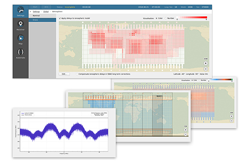
Galileo AltBOC addition
Plus atmospheric corrections
Photo: Skydel Solutions
SDX GNSS simulator update version 19.1 adds Galileo AltBOC signal generation, new atmospheric errors, SBAS improvements and SV antenna patterns. SDX users licensed with the Galileo E5 signal will be able to generate 8 Phase Shift Keying (8-PSK) constant envelope AltBOC after upgrading to SDX 19.1. Version 19.1 also adds a new error type to all SDX users: atmospheric delays. These errors can be compensated for with the SBAS option installed. Skydel Solutions, skydelsolutions.com
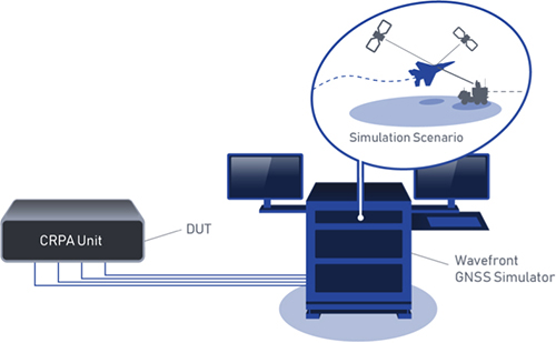
Wavefront simulator
Added to software-defined platform
Photo: Skydel Solutions
The BroadSim Wavefront Simulator is a new addition to Skydel’s software-defined platform. The BroadSim Wavefront further extends the capabilities achieved by BroadSim Anechoic, incorporating support for controlled radiation pattern antenna (CRPA) and multi-element receiver testing. Powered by Skydel SDX, the simulator’s features include phase-coherent simulation, real-time automated phase calibration, scalability from 4 to 16 elements, and advanced jamming and spoofing scenarios. Talen-X, www.talen-x.com
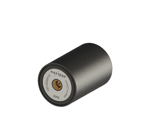
GNSS antenna
For high-precision and autonomous applications
Photo: Maxtena
The M7HCT-A-SMA is a high-accuracy, multi-frequency active quadrifilar helix GNSS antenna designed for high-precision and autonomous multi-frequency applications. The design offers concurrent GNSS reception on L1 (GPS, GLONASS, Galileo, Beidou) and L2 (GPS L2C, Galileo E5B and GLONASS L3OC) in a rugged, compact and ultra lightweight form factor. The antenna is designed for GIS, RTK and other high-accuracy GNSS applications such as the drone and automotive markets. Helicore technology provides exceptional pattern control, polarization purity and high efficiency in a 25-gram form factor. The antenna offers up to 30-dB gain for GNSS applications in one radome housing with a single SMA connector. Maxtena, maxtena.com
Portable simulation
Solution for field-test requirements
Photo: CAST Navigation
The CAST-1000 duplicates GPS RF signals and uses dual-frequency signal generation technology. This allows for duplicate testing in the laboratory or the field and real-time or configured control. The CAST-1000 is mobile and portable, which makes it the ideal solution for field test requirements. Producing GPS and GLONASS signals with up to 12 satellites in view, the CAST-1000 simulates signals for satellites of P code on L1 and L2 and C/A code on L1. The GPS RF signal is dual-frequency and has a 12-channel configuration for any combination of visible space vehicles. The system is highly programmable — operators can choose from an array of vehicle types and replicate dynamic motion for all kinds of vehicles, from terrestrial to aquatic, airborne to space-based. By utilizing 6-DOF dynamic profile data collected in the field and through profile configuration, a trajectory can be created. The CAST-1000 also features a performance evaluation module, allowing for comparisons between raw and filtered data. CAST Navigation, www.castnav.com
Survey & Mapping
Graphing software
New plotting features
Photo: Golden Software
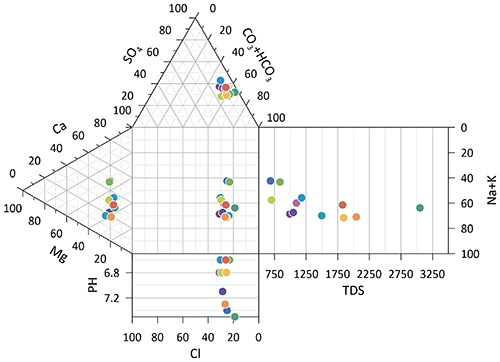
Version 14 of the Grapher scientific graphing package offers new plotting and customizing functionality based on user feedback. The Grapher software gives users deeper insights into their data by providing them with 80 flexible and easy-to-use 2D and 3D graphing tools for plotting, analyzing and displaying scientific data sets. The package is used extensively by scientists and engineers in oil & gas operations, hydrologic/geochemical studies, environmental consulting, mineral exploration and academic research. New or upgraded features include Enhanced Plotting (the ability to plot data in rows and columns, perform one-button Durov class plots, and easily generate multi-plot reports); and Improved Bar Charts (bar charts are more versatile, offering variable bar widths and differentiated fill colors for negative and positive). Golden Software, www.goldensoftware.com
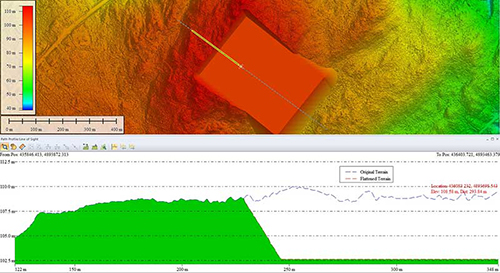
GIS software update
New lidar functionality
Photo: Blue Marble Geographics
Global Mapper version 20.1 offers new and updated geospatial tools, as well as performance improvements throughout the application. Enhancements to version 20.1 include a new zooming function in the path profile window, a digitizer tool for automatically closing gaps between features and, for lidar module users, a point proximity query function. Blue Marble Geographics, www.bluemarblegeo.com
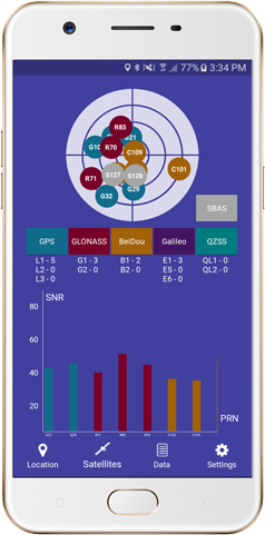
Survey application
For the geospatial industry
Photo: Global GNSS
The GNSS Surveyor mobile application provides location information and quality position data in real time with sub-meter to centimeter accuracy. It connects to any external GNSS receiver via Bluetooth. Features include a one-touch configured command to communicate directly with the GNSS Bluetooth device; location information and quality of the position data in real time with centimeter accuracy; GPS data such as position, height, satellites and velocity; and constellation information for GPS, GLONASS, Galileo, BeiDou, QZSS and SBAS satellites. It also includes a direct IP feature for real-time kinematic (RTK) corrections data. An internal NTRIP client loads RTCM data from the internet. Location information is collected as latitude and longitude, altitude, speed or pace, bearing and UTC time. GNSS precision includes global coverage, centimeter-level accuracy, fast time to first fix, multi-constellation and multi-band, and highest security. Navigation uses include ground robotics navigation, lane-level navigation, heavy machine navigation, industrial navigation and tracking, and commercial UAV. Global GNSS, globalgnss.com
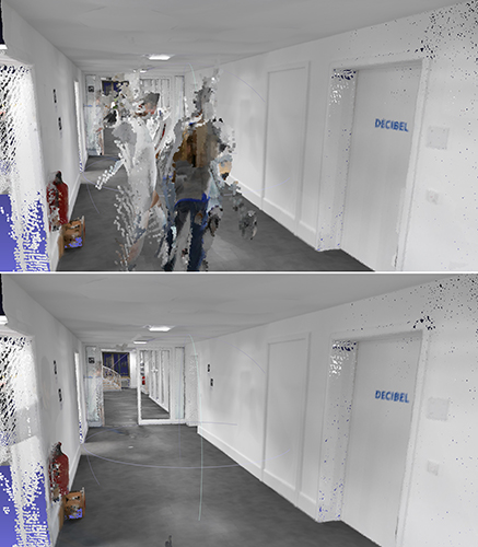
Indoor mapping
Slam technology removes point cloud artifacts
Photo: NavVis
The SLAM-based NavVis M6 Indoor Mobile Mapping System (IMMS) now automatically detects and removes point cloud artifacts, including moving objects in static scenes. The latest IMMS release removes artifacts from point clouds during the post-processing of scan data (see before and after image above). Fringe points and dynamic objects are two common types of point cloud artifacts that affect all 3D laser scanning devices. The NavVis M6 IMMS uses laser scanners to capture a high volume of measurement points of an environment. With the latest software update, the algorithms applied during the post-processing of scan data uses the multiple observations to detect whether measurement points actually exist in the physical space. If it is determined that the point does not exist and is instead resulting from the laser beam hitting an edge or an object moving through the space, this point is automatically removed. The result is a much cleaner, crisper point cloud that requires less clean-up time in point-cloud editing software and that is easier to use for applications such as BIM modeling. NavVis, www.navvis.com
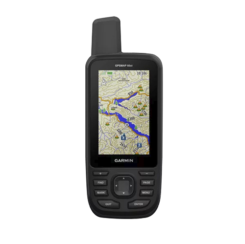
Mobile & UAV
Adventure handhelds
Larger display, improved access to Satellite imagery
Photo: Garmin
Garmin has updated two premium adventure-oriented handhelds, the GPSMAP 66s and the GPSMAP 66st, with expanded wireless connectivity, direct-to-device access to BirdsEye satellite imagery, weather forecasting and a larger 3-inch sunlight-readable color display. The GPSMAP 66st offers preloaded topographic maps for U.S. and Canada, with detail of coastlines, rivers, summits, terrain contours and geographical points. Connectivity to the new Garmin Explore app and the BirdsEye Satellite Imagery (no annual subscription) bring high-resolution photo-realistic route views. Weather updates come via Bluetooth to a compatible mobile device. The Explore app includes features for outdoor navigation, trip planning, mapping and data sharing. Features include multi-GNSS satellite support and altimeter, barometer and compass sensor capabilities; 16 hours of battery life in full GPS mode; LED flashlight and SOS beacon; built to military standards for thermal, shock and water performance (MIL-STD-810G); RINEX data logging that enables sub-meter accuracy of GPS position after post processing. Garmin, garmin.com
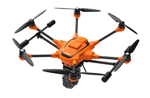
RTK Hexacopter
Integrated GNSS improves accuracy
Photo: Yuneec International
The H520 hexacopter is now available with a real-time kinematic (RTK) system. The fully integrated RTK satellite navigation enables extremely accurate recurring images and faster 3D mapping. It also makes automated inspection flights easier and more precise. The H520 RTK is suitable for commercial applications that require maximum precision. By using RTK technology, the H520 can now fly much closer to objects for inspection because the UAV positions itself precisely in the centimeter range (1 cm + ppm horizontal / 1.5 cm + ppm vertical) rather than in the meter range, which is standard for the H520. Yuneec International, us.yuneec.com
Web-based data service
Enables sharing of UAV data sets
MAGNET Collage Web is a web-based service enabling the sharing and collaboration of UAV and scanning data sets. Version 1.3 allows operators to work with more types of data with greater flexibility, including the ability to import BIM models, as well as CAD and GIS data. It can be used to overlay as-built laser scans and design data to visualize proposed changes and detect construction issues. The software supports OBJ, FBX and 3DS formats. The upgrade also includes new direct publishing functionality for CAD and GIS data files through the browser. Topcon, topconpositioning.com
Kratos Defense & Security Solutions, a developer of advanced unmanned system technologies, has teamed with Royal Truck & Equipment, which builds Truck Mounted Attenuator (TMA) vehicles and highway safety systems, to deploy the Autonomous Truck Mounted Attenuator (ATMA), a self-driving work zone vehicle. The ATMA is an autonomous vehicle that uses driverless technology.
According to the company, highway workers are routinely placed in high-risk situations, but are at especially high risk when assigned to drive a TMA vehicle. The TMA vehicle, also known as an Impact Protection Vehicle, is a truck that follows behind slow moving highway maintenance vehicles as a human-driven mobile crash barrier absorbing the impact of traffic accidentally entering the work zone.
“Driving a TMA is extremely dangerous and drivers are at serious risk of lifelong injury, painful rehabilitation and even death,” said Maynard Factor, business development director at Kratos Defense. “To eliminate this dangerous assignment, Kratos Defense developed the Autonomous TMA (ATMA) by retrofitting standard TMA vehicles with driverless technology to enable unmanned operation.”
The first ATMA systems were deployed in 2017 and have since then been deployed across the United States and Europe. The unmanned ATMA operates in a multi-vehicle leader/follower configuration with a human driven highway maintenance vehicle, the companies said. In the leader/follower configuration, the system enables the maintenance vehicle (leader) to transmit navigation data via encrypted V2V communications to the ATMA (follower). From there, the ATMA uses the data to follow the leader, unmanned, as it travels along the route.
The ATMA systems features component redundancy, an active safety system, high accuracy GPS/GPS-denied navigation, encrypted V2V communications, and multi-modal front and side-view obstacle detection, the companies added. It also includes a user interface that provides system feedback, situational awareness, multi-camera views and operator controls.
“Highways are becoming increasingly dangerous due to distracted drivers texting, following too closely, falling asleep, etc., and work zone fatalities from traffic-related crashes average in the hundreds per year,” Factor said. “Our main goal in developing the ATMA was to increase worker safety by removing them from behind the wheel of a vehicle deployed for the sole purpose of operating as a crash barrier.”
Kratos Defense & Security Solutions will be exhibiting at AUVSI’s Xponential 2019 at booth #226.
Grand Sky Business and Aviation Park and Harris Corp. have joined forces to enable the country’s first and largest unmanned aerial system (UAS) airspace to support beyond visual line of sight (BVLOS) flight operations and UAS Traffic Management (UTM) research.
Stretching up to 100 miles, this BVLOS “super corridor” is the most technologically sophisticated UAS airspace supported by multiple and redundant systems for cooperative and non-cooperative surveillance.
These surveillance capabilities make possible a wide range of UAS BVLOS applications in precision farming, oil and gas, infrastructure inspection, public safety, package deliveries, and others.
“Customers of Grand Sky will have access to a truly unique UAS operational capability, in addition to better facilities, comprehensive airspace surveillance, and wide operational areas,” Grand Sky Development Co. President Thomas Swoyer Jr., said. “We all benefit from efficient and safe BVLOS flight operations and a larger corridor with proven FAA collaboration and flight authorizations.”
The surveillance system combines data feeds from a network of advanced sensors and towers. Two long-range primary radars located at Grand Forks Air Force Base and at Hillsboro, North Dakota, provide detection of non-cooperative aircraft.
The Federal Aviation Administration (FAA) secondary radars and ADS-B network in the region, as well as local Harris ADS-B Xtend sensors, add additional layers of visibility for cooperative aircrafts in the airspace.
Aviation-grade displays help pilots and electronic observers monitor the airspace environment over the BVLOS corridor and safely steer UAS from approaching manned aircraft.
The combination of best practices in aviation safety management, proven technologies and experience with BVLOS regulatory approvals will make it easy for users of the airspace to advance UAS technology commercialization and routine, efficient flight operations.
UAS operators can work with Grand Sky and Harris to develop, test, and refine a variety of complex BVLOS concepts of operations and secure waivers from the FAA for large-scale use.
A full range of UAS operations can be supported for all types and sizes of unmanned aerial vehicles along the BVLOS corridor including a variety of airspace classes and execution of diverse defense, civil and commercial applications.
“This is another first for Grand Sky and North Dakota in leading the UAS Industry,” Harris Vice President and General Manager of Commercial UAS Solutions George Kirov said. “The size and complexity of the airspace opened to UAS BVLOS operations is unmatched in the UAS industry. The sophistication of the Harris BVLOS system at Grand Sky is also unprecedented — linking Harris’ most advanced suite of surveillance and detect-and-avoid services with a variety of surveillance assets that, together, ensure the highest level of UAS aviation safety.”
This partnership lays the foundation for larger and more capable surveillance corridors to enable UAS “highways” across the state of North Dakota and in support of expanding the variety of commercial UAS operations across the United States.
The National Trust for Scotland commissioned Glasgow-based GeoGeo to carry out a drone survey of the inner Hebridean islands of Canna and Sanday in November 2018. Using an ultra-high-definition camera, the GeoGeo team not only pinned down the exact locations of archaeological features, but also revealed new archaeological sites.
Over five days,the drone navigated 400 kilometers to capture 4,000 images at a 3-centimeter resolution. After processing, the images created a minutely detailed 3D map capable of being used in a 3D printer to create scale models of the islands. With more than 420 million data points, it is currently the world’s largest complete island dataset captured by drone, claims GeoGeo founder Paul Georgie.
Screenshot: GeoCue
“We were blown away by the results and the possibilities of this technology,” said Derek Alexander, head of Archaeology at the Trust. “We’ve previously recorded archaeology on Canna and Sanday which proves that there were inhabitants as far back as the Neolithic, but this survey gives us information and detail we just haven’t had until now. We’ve been able to obtain exact plots of known sites, but also recorded the extensive traces of cultivation, such as rig and furrow field systems that range in age from the Bronze Age onwards.”
Screenshot: GeoCue
The cameras and software also will be able to help with seabird counts and habitat and coastal erosion monitoring, which are currently expensive and labor intensive, Alexander said. The trust will use the maps to update archaeological records and prepare for future groundwork and excavations.
By Kazuma Gunning, Juan Blanch and Todd Walter, Stanford University, and Lance de Groot and Laura Norman, Hexagon Positioning Intelligence
UAV and autonomous platforms can greatly benefit from an assured position solution with high integrity error bounds. The expected high degree of connectivity in these vehicles will allow users to receive real-time precise clock and ephemeris corrections, which enable the use of precise point positioning (PPP) techniques.
Until now, these techniques have mostly been used to provide high accuracy, rather than focusing on high-integrity applications. The authors apply the methodology and algorithms used in aviation to determine position error bounds with high integrity (or protection levels) for a PPP position solution.
PPP techniques can provide centimeter accuracy without local reference stations in kinematic applications. These techniques have so far mostly been used to provide high accuracy, and it is only recently that they have been proposed to provide integrity, that is, position error bounds with a very low probability of exceeding them.
There has been preliminary work on the application of integrity to PPP, but it remains a challenge to translate the benefits of PPP to accuracy while maintaining high integrity. Most of the integrity work in PPP and real-time kinematic (RTK) has dealt more with the ambiguity resolution process under nominal error conditions and less on the integrity of the position solution under fault conditions.
The authors overview their PPP filter implementation, and describe the threat model as well as two classes of integrity algorithms: solution separation and sum of squared residuals based (also called residual-based [RB], a misnomer, as all autonomous integrity monitors are based on the residuals.)
They present data sets used to evaluate the algorithms, compare the protection levels (PLs) obtained with different algorithms, and present the results obtained with the most promising PL formulation in four different data sets: static, dynamic in open-sky conditions, dynamic in midtown suburban conditions, and in flight.
Concluding, they state: “We have formulated RAIM protection-level formulas using either solution separation or the sum of residual squares. Both formulations consist of straightforward adaptations of snapshot RAIM to a Kalman filter solution.
“For solution separation, we have shown an implementation where the computational cost of running a bank of filters is far from being proportional to the cost of one filter. Instead, we could run 50 additional filters for the cost of one.
“For residual based RAIM we have developed a set of formulas to update the sum of square residuals from one time step to the next one. Because this test statistic is exactly the same as the one used in snapshot RAIM (when we consider the problem as a batch least squares), we could use the formula that ties the slope of a fault mode to the standard deviation of the solution separation. The slope can therefore also be updated recursively.”
Finally, “we have refined the PPP filter, added one scenario (suburban driving conditions), and examined the effect of considering multiple faults in the formulation of the test statistics and the protection levels. The results are very promising: protection levels below 2 m appear to be achievable, and the computation load is lower than expected.”
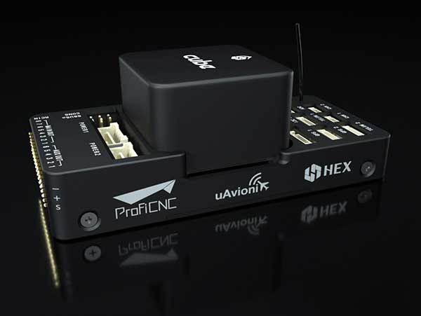
uAvionix has announced a partnership with autopilot maker CubePilot to integrate ADS-B IN receive capability into its carrier board.
uAvionix is the designer and manufacturer of communications, navigation and surveillance (CNS) equipment for unmanned and manned aircraft.
CubePilot is the designer and manufacturer of the “The Cube” autopilot (formerly known as Pixhawk) for unmanned aircraft systems (UAS).
The new carrier board, available in July, integrates uAvionix’s custom ADS-B silicon for 1090-MHz ADS-B reception for worldwide detect and avoid (DAA) functionality.
With this integration, UAS operators will be able to see nearby ADS-B OUT enabled aircraft on ARDUPILOT’s Mission Planner, providing the remote pilot in command (RPIC) with timely notification to take the necessary actions to remain well clear.
CubePilot, which uses the open-source ARDUPILOT platform, previously provided plug-and-play functionality for several uAvionix ADS-B IN and OUT products, including PingRX, Ping2020i and Ping1090i. Support for these products is retained in the new design, allowing for 978MHz ADS-B reception or integration of ADS-B OUT functionality.
“With this partnership, uAvionix furthers our goal of ensuring safety and common situational awareness between airspace users,” states Christian Ramsey, uAvionix president. “We believe that ADS-B IN functionality should be a requirement for every DAA system for UAS operations over people or beyond visual line of sight, and meeting that requirement should not be cost prohibitive.”
“The safe integration of UAS into the National airspace of any country needs to take a safety-first approach from all players,” said Philip Rowse, Hex/ProfiCNC (CubePilot) CTO. “By partnering with uAvionix and including the ADSB-in at practically no cost to the customer, we remove the cost barrier, adding safety to our customers’ UAS solutions.. We envisage this added situational awareness, and optional auto avoidance behavior will be an important step towards safely shared skies.”
Visit uAvionix at AUVSI Xponential in Chicago April 30-May 2 at Booth 4421 and CubePilot at Booth 1816.
AUVSI Xponential 2019 — the huge exhibition and conference built around unmanned everything — will run at the West Building, McCormick Place Convention Center, April 29 to May 2 in Chicago.
This is the premier show for the Association for Unmanned Vehicle Systems International (AUVSI) group and its many members and supporters who have interest in unmanned technology — 8,500 attendees with connection to unmanned and autonomous capability are expected to walk the exhibit hall to see the latest products, hear numerous related presentations, participate in educational courses, and mingle with other like-minded people in the industry.
I was looking for a way to provide a brief overview of the companies exhibiting; a sample cross-section to provide an insight on what to expect. But with more than 700 exhibitors, it’s a difficult thing to do. Then I realized that the company show preview emails in my inbox were from organizations that were actually quite representative of the industry, and I had my overview selection.
Flyability’s drones are adapted for inspection tasks, both indoors and out, with an exterior protective cage. Routine inspection jobs indoors, underground and around complex pipework become quicker, safer and are fully documented by high-resolution video and stills.
This all enables the reduction of costs and process-interruption downtime of industrial inspections, while also reducing to a large degree the risks for inspection professionals. Industries using these inspection drones include power generation, oil and gas, chemicals, maritime, infrastructures and utilities, and public safety.
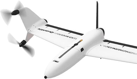
AeroVironment’s drones are used extensively by the military for surveillance and reconnaissance, and in the commercial sector they focus on tools for agriculture.
Quantix drone. (Photo: AeroVironment)
The VTOL (vertical take-off and landing) Quantix drone system is fully automated for takeoff, flight and landing, enabling mapping of farm acreage to monitor crop health to identify anomalies due to water, insect, weed and disease so their impact on yield can be minimized.
Valqari has developed a drone mailbox that is interoperable with a large number of delivery drones and enables drop-off of packages in residential neighborhoods.
The Valqari drone mailbox automatically accepts packages and safely stores them until the recipient opens the box later to retrieve them.
Cepton Technologies makes lidar systems more commonly used for automotive obstacle detection, but now customized for UAV integration and use. Its UAV lidar system provides long-range, high-resolution and low-cost mapping capabilities in a lightweight package. With a scanning range of 200 meters, high-density map-data acquisition becomes possible.
Deseret UAS is a non-profit working to bring UAS business to Utah — the organization offers information, promotes UAS companies and offers test-range access in Utah. In collaboration with Utah State University AggieAir, FAA authority for flight testing in wide open; low-risk operational areas of Utah can be accessed.
And, of course, General Atomics Aeronautical Systems (GA-ASI), manufacturer of the well-known Predator military drone, will exhibit. At Xponential 2018, GA-ASI unveiled its MQ-9B SkyGuardian certifiable drone system. Through the year, the company has progressed towards certification of the system for flight within the U.S. civilian National Airspace System and the civil airspace of other countries around the world.
GA-ASI’s latest media release recounted how an MQ-9B was flown by the company’s Certifiable Ground Control Station (CGCS) on March 9, including both take-off and landing. The CGCS architecture separates flight and mission-critical functions. Off-the-shelf avionics and flight computers are used for flight-critical functions, and mission-critical functions run alongside GA-ASI’s Advanced Cockpit payload and weapons equipment.
Meanwhile, High Altitude Pseudo-Satellite (HAPS) unmanned aircraft are back in the news with what appears to be a crash during the sensitive take-off/climb-out regime. The Airbus Zephyr aircraft — with an 82-foot wingspan, but weighing less than 75 pounds — was engaged in a test campaign in Western Australia when the ground abruptly intervened on March 15.
Airbus is working with the UK Ministry of Defence to demonstrate the operational capabilities of the UAV and its anticipated payload options. Once airborne, Zephyr is intended to climb out to upwards of 65,000 feet into the stratosphere — previously achieving a maximum altitude of 74,000 feet — and has so far been able to remain airborne for almost 26 days. The object is to create a commercial, reusable, reconfigurable satellite-like capability for communications and surveillance applications.
Airbus and MoD are undertaking a crash investigation to determine what exactly happened and how to prevent future recurrence. The incident occurred about four hours into a demonstration flight, and (reading between the lines) may have been related to rapid weather changes that destabilized the UAV while in the take-off and climb-out phase. An automated launch system is in the works — currently Zephyr is man-handled for take-off.
Other HAPS programs include AeroVironment and Japan’s Softbank, Astigan and the UK Ordnance Survey, BAE Systems and Prismatic, and Boeing’s Aurora Flight Sciences. Thales, meanwhile, is apparently focusing on an approach using an autonomous airship.
So some good news, some not so good. Lots of attendees are expected in Chicago for the AUVSI Xponential show, with new developments in unmanned aircraft, robotics, and unmanned ground and water systems anticipated in the exhibition hall. There will be lots of people in the industry with whom to exchange ideas and conduct business to conduct, hopefully just as spring arrives in the windy city.
Meanwhile, over the coming months Airbus will no doubt continue to work out how to overcome the latest problems in HAPS technology and operations.