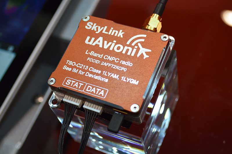
uAvionix, designer and manufacturer of communications, navigation, and surveillance (CNS) equipment for unmanned and manned aircraft, is testing its prototype of a command and non-payload control (CNPC) radio for unmanned aircraft systems (UAS) and urban air mobility vehicles.
Photo: Allison Barwacz
SkyLink is an L-band frequency-modulated CNPC radio ultimately intended for point-to-point or networked Beyond Visual Line of Sight (BVLOS) UAS operations. uAvionix has focused on minimizing size, weight, and power consumption (SWaP) while maximizing range and spectrum efficiency.
The current 50-gram 10-Watt prototype is testing successfully at ranges exceeding 40 miles at low altitude. uAvionix is testing under an experimental transmit license and approval from the Federal Communications Commission and Federal Aviation Administration, respectively.
Prior to founding uAvionix, CEO Paul Beard invented and brought to market the Spektrum digital spread spectrum radio control (RC) technology which moved the control link from 27 and 72 MHz bands to a high-bandwidth 2.4-GHz ISM band.
“Building high performance datalinks for airborne applications is insanely challenging,” said Beard. “Combining our ability to produce TSO certified equipment with the experience of developing and deploying millions of commercial products globally with Spektrum, we expect to bring affordable, scalable, and safe solutions to enable the UAS and UAM markets.”
After 2020, Super Cruise will will be available on all General Motors brands (Photo: GM)
Trimble has announced the availability of Trimble RTX Auto, a GNSS software library written for use in safety critical automotive applications.
The RTX Auto library can be integrated with any GNSS device and enables the decoding of Trimble’s RTX correction stream for centimeter-level absolute positioning accuracy, the company said.
RTX Auto works with other on-vehicle sensors to deliver a positioning solution that satisfies advanced driver assistance systems (ADAS) and autonomous driving requirements.
RTX Auto is both Automotive Safety Integrity Level (ASIL) and Automotive Software Process Improvement and Capability Determination (ASPICE) certified. These certifications validate that Trimble RTX Auto meets functional safety requirements for ADAS and autonomous applications in the auto industry.
“For over 35 years, Trimble has been at the forefront of positioning innovation, accelerating productivity for our users,” said Patricia Boothe, vice president of Trimble’s Advanced Positioning Division. “RTX Auto takes our technology leadership into functional safety applications and allows the automotive industry to leverage Trimble’s leading RTX correction technology. Trimble RTX technology is helping to safely accelerate vehicle autonomy, transforming how the world drives.”
While other correction service providers are validating their ADAS positioning products and services in test environments only, Trimble is on the road today providing RTX-based absolute positioning within General Motors’ Super Cruise, a hands-free driving system for the freeway.
Thales is leading the SESAR Joint Undertaking to research and develop new services for safe, efficient and secure access to airspace for drones.
The SESAR Joint Undertaking (SESAR JU) supports the European Commission’s U-space initiative by researching and developing new services for safe, efficient and secure access to airspace for an expected increase in drone use.
The Geosafe project is part of the founding services for the development of drones operation. Thales will manage the project, supported by Aeromapper, AirMap, Atechsys, Airmarine and SPH Engineering.
The 280 flight tests with 16 different drones will be conducted in France, Germany and Latvia. These tests will explore all possible situations that an automated drone will face in urban and rural areas.
By securing the flight pattern of drones to avoid determined zones, geofencing solutions are key safety enablers. Geofencing ensures that drones don’t fly in protected perimeters around critical infrastructures, such as power plants or airports.
The objectives of Geosafe are to establish state-of-the-art geofencing solutions regarding U-space regulation and to propose improvements and recommendations for future geofencing system definition.
Geosafe will be based on a one-year-long flight-test campaign, assessing a number of commercially available geofencing solutions so that it can propose an improved geofencing system and technological improvements for automated drones.
Thales designs systems ensuring high security and safety levels for future air mobility. As the leader of the project, Thales will organize all tests and provide recommendations for the European geofencing system.
“Thales is playing a leading role in shaping the autonomous world,” said Christian Bardot, Thales VP in charge of Helicopter and UAV Avionics Business. “Together with SESAR JU and the Geosafe partners, we will strengthen the foundations of drones’ safe and secure operations, unleashing the potential of this tremendous market.”
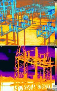
An Arizona electric cooperative that serves more than 33,000 customers is helping prove the value and potential of unmanned aerial systems (UAS) in enhancing the utility’s geospatial information system (GIS) effort.
Using an Intel Falcon 8+ Drone — Topcon Edition, UAS specialist Skynetwest is performing missions to illustrate the viability of UAS technology. Initial work for the Navopache Electric Cooperative (NEC) included inspection of a substation, conducted on a windy day that might have grounded traditional aircraft.
Windspeed limits for the Falcon 8+ in GPS mode are set at 26 mph; in height mode that threshold is extended to windspeeds as high as 35 mph.
Using ContextCapture and Agisoft PhotoScan software, Skynetwest created a detailed georeferenced 3D model of the substation.
The Falcon 8+ also has triple-redundancy inertial measurement units (IMUs), double redundant compasses, dual-constellation GPS, eight propellers and two batteries. An algorithm selects the most accurate of the redundant systems to use when the UAS is flying near the electromagnetic frequencies emitted by power lines.
The team easily switched between a camera payload for inspections and one for mapping. Skynetwest’s mapping package takes high-resolution geo-referenced aerial images from various heights within set GPS tolerances. Its RGB camera delivers both orthophotos and 3D models in Topcon ContextCapture software, powered by Bentley Systems.
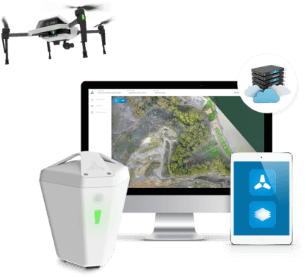
Komatsu Australia and Skycatch Inc. are partnering to boost the efficiency of construction, mining and quarry sites across Oceana with the High Precision Package.
The High Precision Package is also known as Komatsu’s Everyday Drone Solution, a key component to the Smart Construction workflow.
The Everyday Drone contains the Explore1 high-precision UAV, the Edge1 integrated GNSS base station and edge compute module, and the Viewer, an online data visualization and analysis tool, packaged into a commercial-grade kit.
High-precision package. (Photo: Skycatch)
The Everyday Drone allows a user to experience time to data without needing ground control points (GCP), and the ability to seamlessly integrate precision aerial data into their Smart Construction Workflow.
In common construction workflows, the time to data using traditional surveying methods could take weeks until project stakeholders can view or analyze their job site data. With the Edge1, customers are able to leverage a seamless GCP free workflow that consistently delivers sub 50-mm accurate data, in arbitrary or local coordinate systems within 30 minutes, saving countless hours and labor costs.
“We are now using the Everyday Drone at the start of projects to collect whole site information for pre-tender and bidding capability, comparing against 3D design surface to provide fleet and project managers real, accurate information viewed in the Smart Construction Application,” said Aaron Marsh, national technology solution expert manager, Smart Centre, Komatsu Australia. “This allows them to work out their cut and fill volumes with accuracy from the beginning, and enables the project tender team to select the right machines for the project optimising fleet recommendation and empowering the team to make the right, data-based decisions from the start.”
“Skycatch is proud to offer a better way of accessing precision data on-site. With traditional methods, the solutions are piecemeal, cumbersome, and time-consuming,” said Christian Sanz, Skycatch founder and CEO. “Now, customers are able to make informed decisions about changes to what was planned and what is actually happening on site in near real-time, ultimately providing greater productivity, increased profit and reducing project risk from beginning to end,”
Customers tested the receptiveness of the Everyday Drone Solution, said James Mackenzie, national remote support manager at Komatsu Australia. They first tested in civil construction, and then quickly expanded into quarry sites. Mackenzie was able to survey six quarries in five days for different customers, post-processed in the cloud, receiving the data back the next day.
“Compared to a traditional survey, this is 100% more productive and efficient,” Mackenzie said. “By using the Everyday Drone, customers are no longer putting themselves in harm’s way, surveying around heavy machinery or climbing up unstable stockpiles at risk of twisting an ankle.”
He also noted that customers appreciated the fast turn-around time, the ease of use, and the ruggedness of the products.
“Skycatch’s ability to provide near real-time data throughout the entire project is vital, and being able to deliver that to the customer, supervisor and give project teams the ability to make decisions throughout the project easily with usable, accurate data is key to the success of the project as a whole, not just in siloed environments is priceless,” Marsh said.
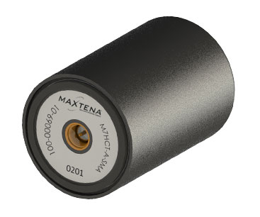
Maxtena Inc. has introduced a patented GNSS antenna designed for high-precision and autonomous multi-frequency applications. The M7HCT-A-SMA antenna is a high-accuracy, multi-frequency active quadrifilar helix GNSS antenna.
Photo: Maxtena
Maxtena is a U.S.-based antenna design and manufacturing company and inventor of the patented Dynamic Aperture Technology.
The new design will offer concurrent GNSS reception on L1: GPS, GLONASS, Galileo, Beidou and L2: GPS L2C, Galileo E5B and GLONASS L3OC in a rugged, compact and ultra lightweight form factor.
The antenna is designed for GIS, RTK and other high-accuracy GNSS applications such as the drone and automotive markets, where high performance and low weight are driving features in antenna selection.
The M7HCT-A-SMA active helix design features Maxtena’s patented compact and lightweight Helicore technology. This technology provides exceptional pattern control, polarization purity and high efficiency in a very compact form factor.
The antenna offers up to 30-dB gain for GNSS applications that utilize GPS, GLONASS, Galileo and Beidou, in one radome housing with a single SMA connector.
The M7HCT-A-SMA will join Maxtena’s line of rugged GNSS helix antennas that are ultra lightweight, small, and precise. The M7HCT-A-SMA weighs 25 grams and is housed in automotive grade PCB plastic with automotive grade electronics and is rated IP67 when mounted.
It is ground plane independent and offers extremely low power consumption and minimal phase-center variation over azimuth. The antenna offers superb axial ratio ensuring multipath error is mitigated.
“Maxtena is very excited to be launching a game-changing antenna for the UAV, drone, and automotive markets, and really for any application requiring a high performance, lightweight antenna that can cover so many frequencies. It is the most robust antenna solution on the market,” said Maxtena Vice President of Sales and Marketing Vanja Maric.
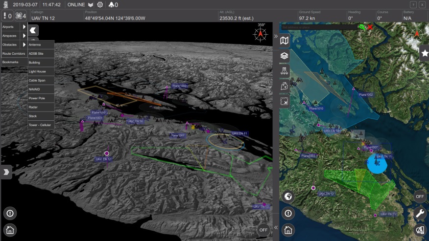
Few commercial UAV operations would be able to inspect transmissions lines, pipelines or train tracks without beyond visual line-of-sight (BVLOS) capability, but these key pieces of infrastructure often situate close to or transit across population centers. Further, many population centers have airports and low-level air traffic. Any tools to keep drones away from air traffic during BVLOS operations will significantly inspection companies. We review three promising solutions here.
Pipeline Inspection
Kongsberg Geospatial in Ottawa, Canada has developed location visualization software tools that are used for air-traffic control, command and control, and air defense applications. The company has several decades of experience in these applications. Its IRIS software was used to support recent UAV oil pipeline inspection operations in Nigeria, providing safety critical airspace deconfliction, supervised by the Nigerian Civil Aviation Authority (NCAA).
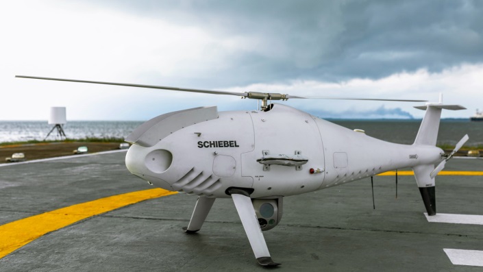
The pipeline project was undertaken by Aerial Robotix, a UAS services provider in Nigeria, who used adapted Kongsberg software in its control center to demonstrate safe BVLOS operations, and was then able to obtain the necessary permits. A Schiebel Camcopter S-100 UAV with a 200-kilometer BVLOS capability was used for flight inspection, operating both day and night, with real time high-definition payload imagery sent back to the control station.
Camcopter S-100 prior to BVLOS pipeline inspection flight in Nigeria. (Photo: Schiebel)
Nigeria has a major problem with gasoline theft from pipelines similar to those lines inspected during this project. Recently, 105 people perished in a blast from a ruptured pipe 30 miles north of the city of Umuahia, possibly during scavenging for leaking fuel. It has been claimed that the pipeline had been ruptured by saboteurs earlier, and for the following six weeks villagers had been collecting fuel. Pipeline vandalism is common in Nigeria, even given the risk of fire or explosion, or the risk of prosecution, or even the possibility of being shot on sight.
Unmanned Companion Fighter Aircraft
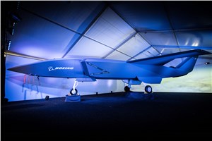
Boeing just unveiled a concept UAV which is apparently aimed at providing an airborne team-partner for manned aircraft.The concept was introduced at the Australian International Airshow by the Australian Minister for Defense, the Hon. Christopher Pyne MP. The project is slated for a significant R&D investment by the Australian Government and Boeing Australia.
Boeing Airpower Teaming System. (Photo: Boeing Company)Boeing Airpower Teaming System. (Photo: Boeing Company)
The concept model has fighter aircraft lines with a projected 2,000-mile range, autonomous capability, and significant intelligence, surveillance and reconnaissance sensor capability. Flying alongside manned fighter/attack aircraft with artificial intelligence simplifying control, the Airpower Teaming System is designed as a low-cost force multiplier.
The concept includes a pitch for international collaboration offering significant customization so countries can add local content, a key element for any aircraft program designed for off-shore sales.
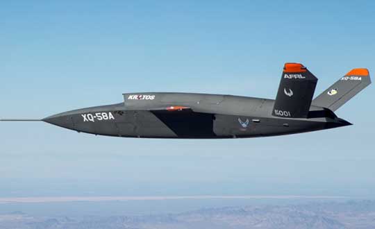
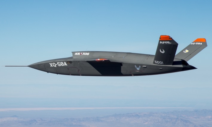
XQ-58A demonstrator in flight. (Photo: U.S. Air Force)
A day or so after the Airshow (maybe not wanting to be upstaged by Boeing’s announcement?) a release showed up about the first flight of the previously secret XQ-58A Valkyrie demonstrator. This is apparently a program by the US Air Force Research Laboratory (AFRL) partnered with Kratos Unmanned Aerial Systems to develop a UAS which looks to have very similar capabilities to that of the Boeing concept, perhaps at a significantly further advanced stage, with a much more mil-spec UAV sounding name.
The AFRL indicated that the XQ-58A is part of a Low Cost Attritable Aircraft Technology (LCAAT) (guess that means they don’t much mind losing a few) effort to come up with low-cost force multipliers which can be built quickly using commercial technology and operating from unprepared runways.
(From the Air Force: “The thought is to develop an inexpensive, configurable and producible on demand air vehicle. A number of military applications can be envisioned for an air vehicle with such a capability. One potential application is to use hundreds or thousands of such units in a campaign to overwhelm an enemy’s air defenses and “punch a hole” to enable higher value, less replaceable [aircraft] to engage or monitor enemy systems. Another potential application is to augment the capabilities of high-value intelligence, surveillance and reconnaissance, systems which may be limited in a specific campaign by distances, quantities, or threats. For all applications, the weapon system is expected to be an air vehicle that would return to base or to a separate location to be recovered. However, because of the mission and because of the low cost, the air vehicle would be attritable, meaning the Air Force would expect and could afford to lose many of the assets.”)
The current program took 2½ years to get to this flying prototype, which still seems pretty lengthy in terms of today’s commercial UAVs. The first flight from Yuma Proving Grounds in Arizona lasted an hour and a quarter and all went as expected. Five test flights are planned to check out functionality, aerodynamics, and launch and recovery systems. Kratos is perhaps better known for its family of target drones which have been in use by the US and internationally for some time.
Kratos BQM-177 Navy drone declared operational. (Photo: Naval Air Systems Command)
Kratos Defense & Security Solutions, Inc. announced in early March that its BQM-177A Subsonic Aerial Target (SSAT) has achieved Initial Operational Capability as reported by the US Navy. A Navy statement said “The first site the BQM-177A will be operated from is Pt Mugu, California. The target is capable of speeds in excess of 0.9 Mach and a sea-skimming altitude as low as 10 feet which provides sea-skimming anti-ship cruise missile threat emulation for the US Navy.”
Parachute System for DJI Phantom 4
Recent testing of the descent rate of a Phantom 4 equipped with a SafeAir parachute system indicated that this UAV/parachute combination may well meet the FAA’s recently published draft rules for flight over people. The parachute system uses on-board indicators to trigger parachute deployment. ParaZero (manufacturer of the SafeAir UAV parachute system) has developed standards, and promises to provide customers with certification data to support waiver applications for flight over people.
Wrap-up
So now we have intuitive software using terrain data and sensor inputs which can provide a visual overlay to supports BVLOS flights, concepts designs and prototypes to support the ‘Loyal Wingman’ approach – flying UAVs alongside existing defense aircraft as force multipliers – and advances towards UAV flight over people using certified parachute safety systems. Just a flavor of the flurry of recent new developments in the world of unmanned aircraft.
A series of documentary videos on automation and technology in the construction and agriculture industries covers drone inspection of infrastructure among other new trends. Filmed in the U.S., the Netherlands, United Kingdom, and Germany, the series of brief films produced by Topcon Positioning Group emphasizes how technological advancements have changed infrastructure — how it is designed, built and maintained — and what to expect going forward.
“The infrastructure industry is changing quickly, and this video series highlights how this advancement is part of a larger story of technology changing the paradigm everywhere. To stay on top, businesses will need to adopt automation and new technology,” according to Topcon spokesperson Jackie Ferreira.
A spokesperson from Intel describes how drone inspection facilitated data gathering and project planning for a complex restoration project on the Great Wall of China, in an area with very difficult access.
NovAtel’s Waypoint Products Group has released version 8.80 of its GNSS and GNSS+INS post-processing software products, including Inertial Explorer, Inertial Explorer Xpress, GrafNav and GrafNet. All Waypoint customers with an active subscription that are within the support period qualify for the Waypoint 8.80 upgrade at no additional charge.
Key features of the 8.80 release include:
High-rate precise satellite orbit and clock corrections available in minutes with the TerraStar-NRT option
Increased accuracy for pedestrian and vehicle applications by applying vehicle constraints using our SPAN intelligent vehicle dynamics modelling
Ability to use L5, E5a, B3 in differential solutions
14 percent faster processing with 64-bit support
For applications requiring highly accurate post-mission position, velocity or attitude, post-processing maximizes the accuracy of the solution by processing previously stored GNSS and inertial measurement unit (IMU) data forward and reverse in time, and combining the results. The position, velocity and attitude solution can be smoothed and output at the required data rate and in the coordinate frame required. This process also provides the ability to assess the solution reliability and accuracy.
The GrafNav and Inertial Explorer software packages are available as a digitally secured machine-portable license. The products are also available as a perpetual license or as a time-limited term license. A Software Development Kit (SDK) is available to allow developers to customize the entire processing workflow to suit their customers or application.
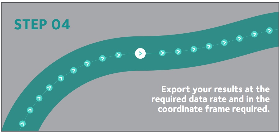
The Waypoint process:
Step 1: Capture raw GNSS and IMU data.
Step 2: Waypoint post-processing software maximizes the accuracy of the solution by independently processing data forward and reverse in time and combining the results.
Step 3: The position, velocity and attitude solution is smoothed to deliver an unparalleled level of accuracy. In-depth quality analysis tools verify the quality of the trajectory.
Step 4: Export your results at the required data rate and in the coordinate frame required.
New app will improve the safety and reliability of drone flights across the United States.
The Federal Aviation Administration (FAA) has partnered with Kittyhawk to redevelop B4UFLY to further its safety mission and create a new and improved mobile application to help recreational drone operators learn where they can and can’t fly.
The project is being done at no cost to the FAA.
Photo: FAA
The B4UFLY app will continue to be available to the public until the new app is deployed. The data will continue to be updated, but no new features will be added.
“We want to provide drone pilots with the best tools possible so they fly safely and responsibly,” said Acting FAA Administrator Dan Elwell. “As drone sales increase and our nation’s airspace becomes busier and more complex, it’s vital that we work smarter and partner with the private sector to develop innovative products that advance safety.”
The FAA and Kittyhawk’s Feb. 13 agreement will provide the public with a simple, easy-to-understand mobile application that provides situational awareness for recreational drone pilots. The FAA and Kittyhawk plan to launch the new app later this year.
Kittyhawk is an enterprise drone operations software company and has been an FAA Low Altitude Authorization and Notification Capability (LAANC) UAS service supplier since October 2018.
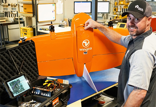
Swiss-based Wingtra, creator of professional vertical takeoff and landing (VTOL) surveying drones, and RDO Integrated Controls, a division of RDO Equipment Co., have rolled out the first Wingtra Certified Repair Center.
The agreement between the two companies further enhances RDO Integrated Controls’ customer support to a growing Wingtra customer base.
Specifically, the training and certification process delivered by Wingtra will greatly reduce downtime when repairs or maintenance is required across RDO Integrated Controls’ territory, which includes the U.S. upper Midwest, Pacific Northwest and Southwest.
Along with advanced technical training, the agreement includes strategic warehousing of Wingtra systems and components across RDO Integrated Controls’ regions.
“This is a monumental step in our joint efforts to not only deliver the best professional VTOL surveying drone available, but to also provide our customers with unbeatable long-term support,” said Scott McTavish, North American sales manager at Wingtra. “Our advanced aerial surveying platform is enhancing the industrial workspace in so many ways. We are fortunate to have a partner in RDO who shares our values of caring for our end users. Rapid response and local support is key to user satisfaction.”
“The addition of the Certified Repair and Service Center is the next logical step in our winning relationship with Wingtra,” Brad Reich, service operations manager for RDO Integrated Controls, said. “RDO and Wingtra can now provide UAV customers with the best service and support in the North American market.”
The new service and repair capacity at RDO means rapid response and local long-term support for WingtraOne customers. (Photo: Wingtra)
Wingtra develops, produces and commercializes high-precision VTOL drones that collect survey-grade aerial data. Wingtra entered the market in early 2017 and has been selling globally ever since.
Founded in 1968, RDO Equipment Co. sells and supports agriculture, construction, environmental, irrigation, positioning and surveying equipment and is a total solution provider.
Changes to the Federal Aviation Administration (FAA) operational drone restriction were recently proposed in order to allow some flights over people. This proposed rulemaking appears to be a major step forward. Mail-order delivery flights, newsgathering, real-estate sales movies and building inspection, to name a few markets, all begin to make more sense, maybe even become viable.
Some night operations could also be possible.
Risk assessment methodology appears to be logical; a number of UAV categories are proposed, and there is a way to assess if operators are in compliance.
The Alliance for System Safety of UAS through Research Excellence (ASSURE) undertook a ground impact study to determine the possible risk of injury to people from drones falling out of the sky. Assessments were made using existing automotive standards and a military standard for debris impact, plus there was testing using automotive crash dummies.
It was a lot of work, but the bottom line appears to be that possible injuries to people are more likely to be minor than major. Bear in mind that UAS fly at relatively low altitude, are made with materials that make them somewhat elastic in nature, and that it may be possible for people in a crowd to see a flailing, falling UAV and move to avoid an impact.
Nevertheless, I do have a picture in my mind of a wayward drone crashing to the pavement after hitting a skyscraper in San Francisco, and I’m really glad I wasn’t down on the sidewalk below.
Urban building inspection using drones. (Photo:AeroSIM RC)
Then I read an article by James Poss, a retired military major, who seems to suggest that although the conclusion of the ASSURE assessment was that 2,000 grams was an OK weight for an sUAV to avoid serious injury to anyone, the FAA appears to have proposed limitations for sUAS which are only 1/10th of this weight. This is more in line with the weights in the mil-spec standard that are based on small, fast, solid-metal blast fragments.
It might help us to also consider how often or badly people are injured by golf balls, baseballs, tennis balls or squash/racket balls — for instance, I’ve survived several golf ball impacts and even an impact with a squash racket during play without major damage. These are things we all take in our stride as part of (almost) normal human activity. I wonder how often recreational enthusiasts have actually been injured during model-aircraft flying gatherings?
FAA restricts flights over government facilities
In cooperation with the Department of Justice (DOJ) and the Department of Defense (DOD), the FAA has just established temporary restrictions on drone flights within 400 feet of the lateral boundaries of a number of sensitive federal facilities. This is in addition to previous restrictions over prisons, NGA facilities, DoD ships and other facilities.
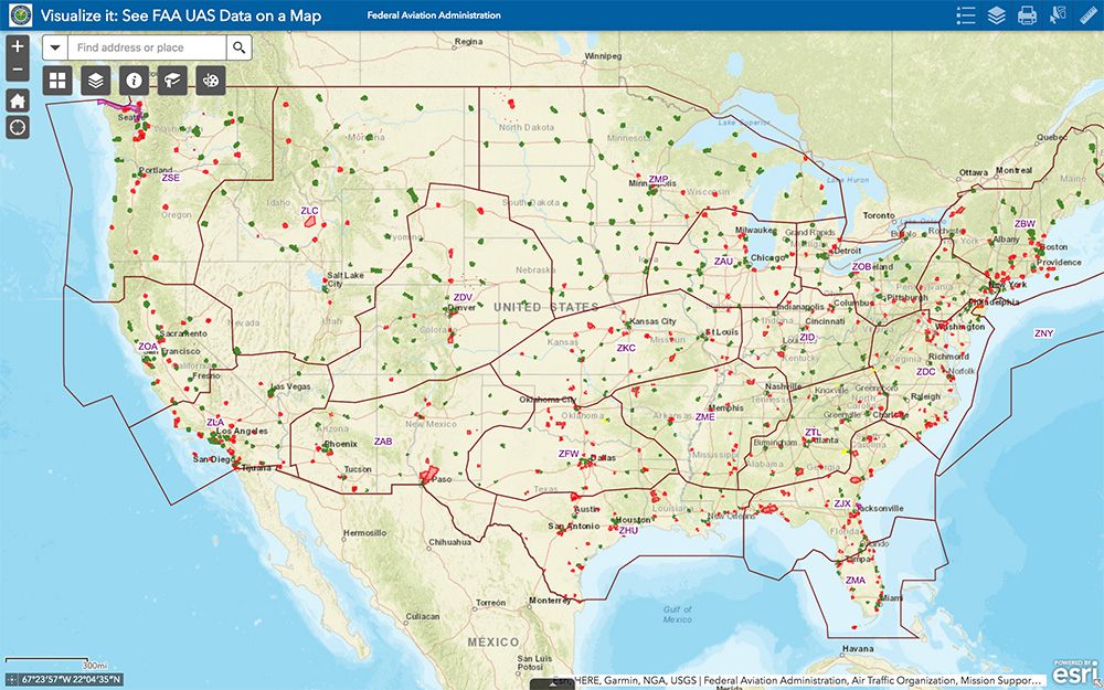
The most recent proposed Notice to Airmen (NOTAM) lists federal correctional facilities in almost half of the states in the U.S., several medical centers, U.S. Army facilities, ammunition plants and Pearl Harbor in Hawaii. It’s hard to understand why there aren’t already permanent UAV prohibitions over all such sensitive facilities across the whole U.S. I tried to check status, but the FAA UAS Data Display System didn’t list this proposed NOTAM which apparently goes into force on Feb. 26.
Think it’s probably a question of preventing bad guys from planning or doing harm rather than being shy to be caught on video — but, for sure, these places should be as secure as possible.
The FAA UAS data map shows all drone-restricted areas, once updated. (Screenshot: FAA)
Security at the Super Bowl
Well the game wasn’t the most exciting, with New England doing all that was needed to win in the fourth quarter, but the security for the event in Atlanta was humongous.
The area around the stadium was cleared of threats even before the game, attendees were screened for prohibited items and the airspace within 30 miles was restricted for general aviation and drone access. There were even Defense Department F-16 airspace patrols, and the Customs and Border Patrol had a Black Hawk helicopter available to intercept any aircraft penetrating the exclusion zone.
Nevertheless, the FAA still approved the operation of two tethered drones. One was flown close to the stadium by security personnel to provide live images of crowd movements in and around the stadium. The second system was operated at 45 meters above the rooftop of the CNN building facing the Mercedes Benz Stadium. CNN used it to provide aerial imagery of the scene before and after the game.
Elistair base station and DJI M200 at Super Bowl. (Photo: Elistair)
The tethered drone setup included two DJI M200 drones and two Elistair Ligh-T base stations, with monitoring, control and power provided to each drone by lightweight tethers. The security system was continuously operationed for 10 hours of captive flight during the Super Bowl, and for 14 hours total over two days — all while tethered to the Ligh-T control station. Security officials expressed their interest in using this solution more often because of the ability to follow a subject continuously without having to switch from one fixed camera to another, which risks losing the subject.
To sum up, new pending FAA regulations that support operations over people may have a few flaws. Other new FAA rules are aimed at protecting DOD and DOJ facilities from drone overflights, and tethered drones were used at the Super Bowl for crowd security and by CNN for color coverage.
New applications, new opportunities and preventive controls to maintain security at sensitive facilities — all moving in the right direction.