“As of today [Nov. 28] Tesla owners have driven 1 billion miles with Autopilot engaged,” the company announced via tweet.
The Autopilot feature became available in 2015 and now comes on all new Tesla models with a $5,000 activation fee at the time of purchase or $7,000 if selected later.
The company is training its “neural networks” to improve its self-driving system.
Photo: Tesla
Tesla’s global fleet totals more than half a million vehicles, and recently marked a 20-billion mile step of total electric miles driven, the company said.
The Autopilot system can also function in the background of the vehicle, without being activated and with no input on control. Thus it gathers data from many more billions of “drivered” miles about its environment and potential Autopilot behavior.
The company previously mentioned the 1 billion-mile autonomous mark as the minimum it would need to move Autosteer from beta to a regular feature.
Updates to Autopilot are planned for 2019, including new hardware that will aid in the rollout of the company’s Full Self-Driving system, possibly by the end of that year.
The U.S. Department of Transportation’s most recent document preparing for the future of self-driving cars almost entirely ignores positioning, navigation and timing (PNT) needs, according to the Resilient Navigation and Timing (RNT) Foundation. And when it does address GPS, it gets things wrong. A Dec. 3 deadline looms for interested parties to file their comments with DOT.
The comment period is open until December 3. Interested parties can make their own comments and read those already submitted at the website for Docket DOT-OST-2018-0149.
The cited comment from the RNT Foundation states that, while most self-driving cars are being designed to navigate without external inputs, GPS/GNSS will still be required to initialize location information for vehicle cold startups. Also, most vehicles will reference GPS/GNSS when communicating their positions to other vehicles and traffic control systems.
Much of the benefit of automated vehicles will come from their participation in Intelligent Transportations Systems. This means wireless networks. The RNT Foundation also urges the department to consider these networks’ critical dependence on GPS timing synchronization in their plans going forward.
(Image: Pavel Vinnik/Shutterstock.com)
The Secretary of Transportation has had a mandate to provide a backup capability for GPS since 2004 that has not been acted upon. The RNT Foundation comments observe that doing so could greatly mitigate all of the concerns mentioned.
Dana Goward is president of the Resilient Navigation and Timing Foundation, based in Washington D.C.
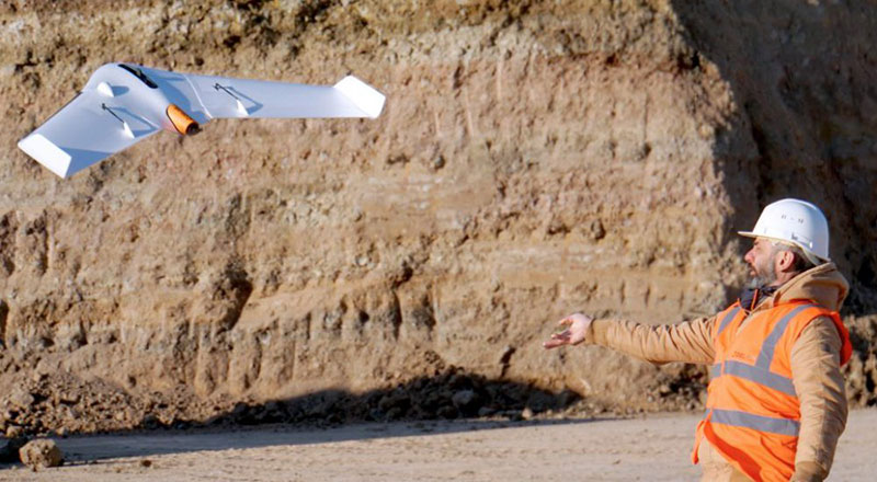
Exploring a wide area in search of a hazardous substance emitting source or expansion of a fire front is an ideal UAV mission. Wildfire monitoring missions exemplify such a problem.
Most multi-UAV systems address problems related to search in an environment of interest. The UAVs cooperate and share data to obtain information within a certain aspect of the environment.
Regardless of the number of UAVs and size of the area of interest (AOI), cooperative systems deliver a perfectly up-to-date picture of the environment with coordination.
This paper investigates a coordination scheme for missions facing uncertainty about the periphery in the AOI. It takes into account the UAVs’ state, observations, the overall mission, and allocates each UAV to a specific task, enabling the multi-UAV system to act in a coordinated manner.
If a coordination algorithm for an environment with uncertainty is available, the overall system still leans on sensing capabilities. Even if the system uses the most advanced sensors, sometimes the environmental conditions are restrictive; that is, UAV sensors cannot reach far enough, and measured data can only be local and quantized data.
The goal of quantized estimation is to develop techniques to effectively reconstruct the data. The research approach relies on a technique for estimation of propagated boundary with quantized measurements and proposes a new class of one-dimensional estimator: the Greedy Uncertainty Suppression (GUS) strategy.
The monitoring application involves large numbers of possibly randomly distributed inexpensive sensors, with limited sensing and processing. The estimator incorporates observations gathered by multiple observers and uses the quantized kalman filter estimation to update the expected location and unobserved spreadrate.
A roundup of recent products in the GNSS and inertial positioning industry from the December 2018 issue of GPS World magazine.
OEM
Combination antenna
Long-range connectivity
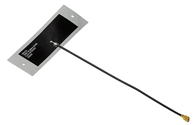
Photo: Molex
The Molex highly compact 2.4/5-GHz combination GPS/Wi-Fi ceramic antenna is designed to be a cost-competitive solution covering the full GNSS band, 1.561 to 5.85 GHz. The triple-band ceramic antenna has Wi-Fi HaLow compatibility and is interference-resistant, supporting larger but lower (900-MHz) frequency ranges than 2.4/5-GHz connections. It also operates with lower power over longer ranges than 2.4/5-GHz Wi-Fi. Advanced Wi-Fi applications the internet of things, connected cars, smart homes and smart cities.
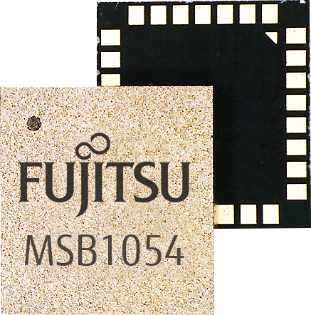
The MSB1054 multi-receiver module requires no external components, meeting needs of smartwatches, fitness trackers, logistics and navigation. Its Flash memory saves navigation data to optimize performance and provide a hot start. The ability to receive signals from several satellite systems significantly reduces the time to first fix. The module provides a built-in RF-front end (SAW filter, low-noise amplifier) as well as a temperature-compensated crystal oscillator (TCXO), so no external component is required other than an antenna. It measures 5.8 × 6.2 × 1 millimeters and uses 3.4 mA current in low-power mode, such as for tracking.
The GE310-GNSS is an internet of things (IoT) module with GSM/GPRS, multi-constellation satellite positioning and Bluetooth functionality in a 270-millimeter-squared form factor. It meets European demand for GSM/GPRS compact form factors and is part of Telit’s migration-support program that helps customers leverage 2G’s low cost and broad coverage while preparing for 4G and 5G. The GE310 enables OEMs and system integrators in asset management, utilities and telematics to meet the strong demand for low-cost, highly compact devices without tradeoffs in performance, reliability and functionality, particularly in regional markets such as Europe, where 2G is forecast to remain in strong growth in number of IoT connections for many years.
With multi-sensor fusion positioning and orientation
Photo: Unicore
The CLAP-B multi-GNSS/MEMS integrated inertial navigation board features a miniaturized high-performance inertial measurement unit (IMU) on a compact high-performance GNSS board. The high-accuracy GNSS positioning coupled with a high-precision gyro and accelerometer provides stable, continuous 3D position, velocity and attitude, as well as original acceleration and angular velocity measurements, even in GNSS-denied environments. CLAP (Concurrent Localization & Attitude Pilot) technology is a high-precision multi-sensor fusion positioning and orientation technology developed by Unicore. The board is compact, light weight and has low power consumption. It is designed for ease of integration and mass production, and is suitable for autonomous driving, smart surveying and UAVs.
The UNI-GR1 RTK GNSS receiver offers highly accurate heading and positioning output. It can be connected to any device through Wi-Fi, mobile data, radio, USB or serial cable. It simultaneously tracks GPS L1/L2/L5, GLONASS L1/L2, Galileo E1/E5a/E5b and Beidou B1/B2/B3 on 432 channels. The receiver has a built-in level, a LED ring driven by a nine-degrees-of-freedom inertial measurement unit. Users can configure numerous settings such as real-time kinematic, or begin surveying immediately with a smartphone or laptop.
Dynamic tilt functionality has been added to the Trimble SPS986 GNSS smart antenna. The dynamic tilt upgrade allows for faster data collection to enable construction surveyors to create larger digital terrain models faster and with improved accuracy. It can capture higher accuracy measurements on steeper slopes from a moving vehicle and more accurate volume measurements to save time and money on material planning. The dynamic tilt measurement mode also auto-measures antenna height. From inside the vehicle, contractors can set the height of the antenna and quickly interrogate surface models using the real-time 3D surface display in Trimble Siteworks field software.
The Skycatch Edge1 is an on-premise data processing and GNSS base station optimized for the Skycatch Explore1 and DJI Phantom 4 RTK drones. Field teams can fly a drone, process the data and receive centimeter-level data output in 30 minutes or less, directly to a tablet, without the need for internet or cellular connectivity. 2D maps and 3D point clouds can be shared from the tablet. The Edge1 includes built-in WiFi, LTE and reliable sub-5-centimeter accuracy, and delivers high-quality data output. It is also capable of running deep learning algorithms to extract more insights from collected data in near real time.
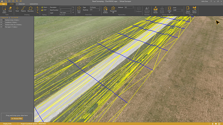
Drone surveying software Virtual Surveyor now eliminates the need for clients to use third-party applications to prepare data for processing. Version 6.1 handles on-the-fly projections that previously required a separate software package to set the data in the proper coordinate system. It bridges the gap between UAV photogrammetric processing applications and engineering computer-aided design (CAD) packages. The software generates an interactive onscreen environment with UAV orthophotos and digital surface models where the surveyor selects survey points and breaklines to define the topography, creating highly accurate topographic products for CAD input up to five times faster than otherwise possible. Surveyors can drag and drop all kinds of files into Virtual Surveyor: points, raster, vectors and point clouds. The point clouds are converted to a DSM for manipulation and processing, dramatically accelerating the time required to generate the CAD model.
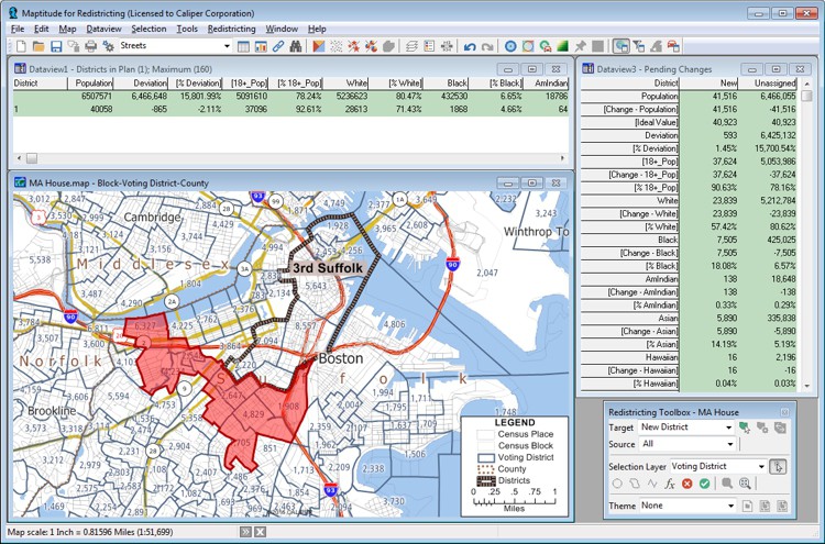
Includes Efficiency Gap Measure to explore redistricting problems
Screenshot: Mapitude
Maptitude for Redistricting is a professional tool for political redistricting. Maptitude provides measures and reports that support the creation of fair and balanced districts, and regularly enhances the software. Maptitude was used to democratize redistricting in California and is used by redistricters from independent commissions, non-profits, and civil rights groups, to the courts and political parties.
Stockpile measurements are up to 80% more accurate
Photo: DJI
The DJI Mavic 2 Pro drone is now part of the Kespry stockpile measurement solution for mining and aggregates companies. Kespry’s stockpile measurement solution produces data up to 80% more accurate than manual measurement. All of the survey data is stored in a central cloud application, accessible for analysis by the entire team. Large aggregates and mining companies can standardize and capture stockpile data across all their sites in the Kespry platform, while using Kespry 2s or DJI Mavic 2 Pro drones.
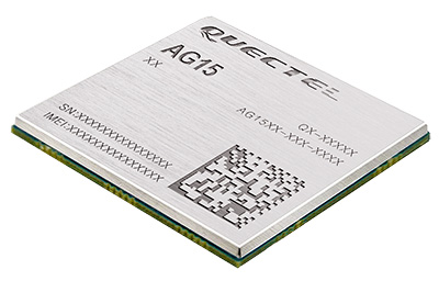
Designed for next-generation automotive applications
Image: Quectel
The automotive-grade C-V2X module AG15 features the Qualcomm 9150 C-V2X chipset paired with Quectel LTE module AG35. It is designed to meet the telematics and vehicle-to-everything (V2X) connectivity requirements of autonomous driving and road safety. It features a built-in multi-constellation high-precision GNSS (GPS/GLONASS/BeiDou/Galileo/QZSS) receiver with additional support from satellite-based augmentation systems (SBAS) and Qualcomm 3D dead-reckoning technology, which improves positioning accuracy and speed while simplifying customer designs. It is designed to allow low-latency, highly reliable and highly dense data exchange between vehicles and their surroundings, enabling effective information sharing among road users to avoid collisions, thus improving automotive safety, automated driving and traffic efficiency.
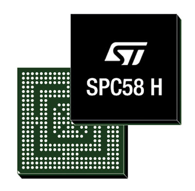
The SPC58 Chorus H microcontroller (MCU) line can run multiple applications concurrently to allow more flexible and cost-effective vehicle electronics architectures. The line is designed for high-end body, networking and security applications such as gateways, body-control modules, battery management and ADAS safety systems. The line has three high-performance processor cores, more than 1.2-MB RAM and powerful on-chip peripherals. The MCU securely delivers updates over the air for vehicle powertrain, body, chassis and infotainment features. With high security and large on-chip code storage, ST’s Chorus automotive microcontroller is a gateway/domain-controller chip capable of handling major OTA updates securely. Two independent Ethernet ports provide high-speed connectivity between multiple Chorus chips throughout the vehicle and enable responsive in-vehicle diagnostics.
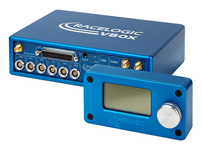
The VBOX 3i RTK is a real-time-kinematic-enabled version of the VBOX 3i dual antenna that can be used in conjunction with an RTK differential base station to obtain ±2-centimeter positional accuracy in real time at 100 Hz. The data logger combines the advantages of a twin antenna GPS setup with GLONASS satellite tracking. It can be used in vehicle tests where positional accuracy and repeatability are of key importance, such as lane departure testing, distance to a fixed object or precise mapping. The VBOX 3i RTK comes with the VBOX manager, a display enabling users to change dynamic modes and filter settings, set up slip angle data and define antenna locations.
The StarLink TrackerWi‑Fi advanced vehicle-tracking device combines u-blox GNSS, 4G and Wi-Fi technology, eliminating the need to equip vehicles with a separate mobile Wi‑Fi hotspot. StartLink is suitable for applications for connected cars, telematics, vehicle diagnostics, fleet management, vehicle security, usage-based insurance, and rental and leasing service companies. With the Wi‑Fi hotspot, users can tap into cellular 4G to transfer telematics data to the fleet manager and send real-time data to the driver’s smart device or infotainment system.
The Notilo Plus team with the iBubble. (Photo: Notilo Plus)
Notilo Plus has launched iBubble, a fully wireless, autonomous and intelligent underwater drone that can be used for search-and-rescue operations, naval or underwater infrastructure maintenance, and subsea patroling. iBubble can accompany divers for up to an hour and down to 197 feet depth, enabling superior underwater imaging. The remotely operated vehicle (ROV) was designed using a patented underwater localization technology, which is mainly based on acoustic signal transmission and image recognition (video tracking). By combining these technologies, iBubble is able to locate precisely its target underwater and shoot stable footage. The iBubble is equipped with an obstacle avoidance system, real-time image recognition, a stabilization system and direct surface control.
Anafi Work is an ultra compact tool for professionals, helping them make informed decisions using the drone’s aerial insights. Anafi Work includes the advanced Anafi drone equipped with an innovative imaging system, a 4K/21MP camera with a 180° vertical orientation, allowing users to capture images of inaccessible areas.The drone operates for 1 hour and 40 minutes with its 4 USB-C smart batteries. It can be transported anywhere in a compact shoulder bag. Professionals can create 3D models of buildings, quickly and easily, using a one-year subscription to Pix4Dmodel.
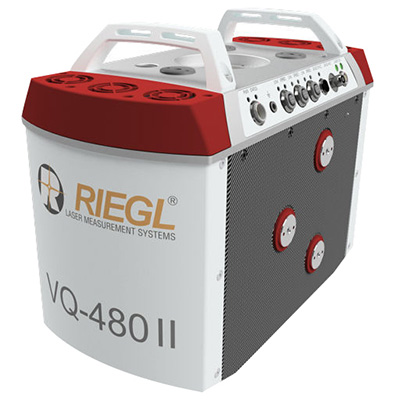
The Riegl VQ-480 II and VQ-580 II are designed for airborne applications at mid-altitudes for use on both manned and unmanned aircraft. The new Mark 2 designs of previous models improve both performance and user-friendliness. Both offer a measurement rate of up to 1,250,000 measurements/second and a 75-degree field of view of suitable for corridor mapping, city modeling and applications in agriculture and forestry. Weighing approximately 10kg, they are ready for integration into helicopters and unmanned UAVs with a higher payload capacity. The VQ-480 II and VQ-580 II are prepared for smooth GNSS/IMU integration, offer interfaces for up to five optional cameras, and are have built-in and removable storage.The VQ-480 II works at a laser wavelength of 1550 nm; the VQ-580 II at the1064 nm wavelength suited to measure on ice and snow.
DroneNode is a portable, compact and inconspicuous counter-drone jamming device that law enforcement can use at large outdoor events without raising public concern (it is not yet authorized for use in the U.S.) It can simultaneously jam 2.4 GHz, 5.8 GHz and GNSS L1 and L2 bands up to one kilometer, causing drones to return to their point of origin or land. It is also effective against swarm attacks. Emergency broadcasts, cellphone communication and other dedicated channels are unaffected.
Skydio R1 users now have the ability to follow cars. New modes include Car Follow, improved Lead Mode, and other improvements throughout the system, which is built on top of the Skydio Autonomy Engine. The engine operates 13 cameras, enabling it to map and understand the world in real time, allowing it to be fully autonomous and independently capture video footage. Its Nvidia Jetsonl AI runs neural networks that trained for the Car Follow feature on datasets of automobile images.
Septentrio, Kespry share UAV advances; Game of Thrones, Mission Impossible also highlighted in GPS World webinar.
The UAV inspection industry continues to grow, as evidenced by these case studies of end-user application, presented in a free webinar available to readers of GPS World. As unmanned systems follow precise flight paths to gather data needed for missions in — to cite just a few examples — insurance, mining, construction and the pulp paper industry, they drastically reduce project time, workload and costs.
Narratives of how these tasks and other inspections are performed, and the requirements and challenges for positioning technology they pose, made up the October webinar, “Development Trends and Challenges for UAV Inspection Applications.”
Four expert speakers covered commercial applications in urban and remote areas, including issues generated by obstruction, interference and spoofing. The full webinar audio and slides are available for download.
Septentrio. Gustavo Lopez, product manager for Septentrio, introduced the webinar and covered the main technical challenges and requirements for UAS inspection applications: reliable and accurate relative positioning and orientation; power efficient, vibration-robust technology; fail-safe systems; all-weather flying capability; long-duration precision flying; small data compression; sense and avoid mechanisms; and network centric infrastructure.
Lopez specified the capabilities an onboard GNSS receiver must have: interference monitoring and mitigation, and anti-spoofing — and briefly displayed the company’s products tailored for UAS inspection.
These include: AsteRx-m2, a single-antenna RTK/PPK base and rover; AsteRx-m2a, a dual-antenna RTK chip with 2D orientation; AsteRx-m2(a) UAS, an auto-pilot ready device for easy UAS integration; and AsteRx-i, a GNSS/inertial solution with RTK and 3D orientation.
Multi-Drone Mapping. Todd Humphreys from the University of Texas presented recent research developing the concept of collaborative mapping with multiple drones, creating a 3D display with decimeter accuracy. Ultimately the products from this prototype will serve in autonomous driving applications.
Humphreys displayed the Sensorium, an automobile equipped with stereo cameras, dual-antenna triple-frequency software-defined GNSS, an industrial-grade IMU, automotive radar, LTE connectivity — and a companion deployable UAV for reconnaissance.
Representing “eyes in the sky” for difficult or dangerous intersections. This little fellow carries a dual-antenna GNSS-IMU system developed in-house based on a software receiver delivering centimeter-accurate 2-degree UAV pose estimates.
The webinar then progressed to several Septentrio clients who are out on the leading edge of UAS inspections.
Kespry provides a complete solution for construction and engineering companies to better manage proposed and active earthwork operations. Without using multiple, cumbersome ground control points, survey-grade field data can be collected for an entire site in as little as 30 minutes. (Photo: Nathan Stump/Kespry)
Kespry. UAV manufacturer Kespry provides a complete solution for construction and engineering companies to manage proposed and active earthwork operations. Without using multiple, cumbersome ground-control points, survey-grade field data can be collected for an entire site in as little as 30 minutes.
Attendees learned how drone technology is being used to:
Validate proposed earthwork – reduce rework and extra earthmoving costs before the job begins
Safely measure earthwork activity – ensure subcontractor work and delivered material are constantly measured
Applied to insurance claims for inspections of roof damage, Kespry’s autonomous system improves safety, reduces loss adjustment expenses, and delivers more accurate assessments, while reducing overall costs.
For commercial property, the UAV solution helps prevent losses and informs underwriting decisions with high-resolution aerial and thermal imagery to identify exposures. Mobile tools are provided to review inspection imagery within minutes of flight; artificial intelligence technology generates fully dimensioned wireframes and 3D roof models.
Flying Cam. The webinar links to a YouTube video presentation by Flying-Cam CEO Emanuel Previnaire, showing exciting film footage from popular entertainment. Flying-Cam was closely involved in Game of Thrones, season 7, filming in Los Barruecos Natural Park in Spain; and Mission Impossible 6, filming in the heart of Paris.
The footage, delivered by the company’s UAVs flying very exact, high-speed pre-programmed flightpaths, was used to cinematically recreate flying dragons and exciting helicopter stunt work has been recognized over the years with two Oscars and one Emmy.
The Flying-Cam SARAH E unmanned helicopter, with a payload capability of 10 kg, is open to many sensor integrations. Recent projects have included several high-end sensors: magnetometer, hyperspectral camera system, lidar and more.
Flying-Cam introduced the specific use case of their customer Altametris, in a solution for rail inspection applications. Flying-Cam’s SARAH E successfully performed a lidar aerial survey in a populated area, the train station of Marseille Saint-Charles.
Altametris. A subsidiary of the French National Railway (SNCF), one of the densest and most complex networks in Europe, Altametris participates in monitoring and inspecting a system encompassing 58,000 kilometers of track, 1,700 tunnels, 27,000 bridges and 3,000 stations by using non-intrusive measurement methods (UAVs, robots and more).
Challenges for beyond-visual-line-of-sight (BVLOS) inspections of this vast network include countless obstructions, safety and regulations governing flights over populated areas, and the need to avoid interference with railway operations.
A typical rural scenario of long-range inspection involves a fixed-wing UAV with camera, lidar, multispectral camera and other sensors, flying at 150-meter altitude over a 50- to 100-kilometer stretch. Urban inspection uses rotary-wing UAVs with camera and lidar at even lower altitude (50 meters), along a 5-kilometer corridor.
Employing GNSS/INS solution for positioning and georeferencing combined with lidar leads to precise and valuable data (high-density point cloud, up to 1000 points/square meter). A highly accurate and robust GNSS system is also mandatory for safety and security as it could help to monitor and avoid drone fly-away.
Robust GNSS systems are therefore a key technology for the UAV industry and could open new business opportunities, through safe deployment in inhabited areas, high quality data for metrology,and more.
This report covers a number of UAV topics, including the news of another U.S. Federal Aviation Administration (FAA) program to advance drone integration in the U.S. National Airspace System (NAS); an initial effort towards Type Certification for a larger UAV/UAS; cautious steps to protect U.S. Navy and Coast Guard ships from unwanted drone overflight; and what would appear to be a surge in the number of acquisitions across the industry.
FAA Integration Pilot Program
There are signs of growing momentum to get UAVs flying in the U.S. NAS. The FAA Integration Pilot Program (IPP) website indicates that this latest initiative is spread across a number of different applications, locations and supporting organizations. The FAA cites the following objectives for IPP:
Connecting local and national UAS integration interests
Improving local, state and tribal communications
Addressing security and privacy risks
Speeding up special authorizations.
So it’s perhaps more about getting organizations at the local level into the picture, and fostering cooperation with national interests. But, at the same time, pilot projects will feed knowledge into the hopper of how to get UAVs into the U.S. NAS.
Operational concepts to be investigated include night operations, flights over people, flights beyond visual line of sight, package delivery trails, testing detect-and-avoid technologies and verifying the reliability and security of UAS data links.
Certification Program underway for Insitu ScanEagle3
Along the same lines, Insitu is working with FAA staff towards certification of the commercial ScanEagle3 drone system to enable flights in U.S. controlled airspace. A recent three-day Type Certification Board meeting held between FAA and Insitu included launch-to-capture flight tests, plus review of applicable standards, flight training and technical publications and manuals to determine Insitu’s basis for the proposed UAS Type Certification of the ScanEagle3 in 2019.
Once an aircraft or UAS gains Type Certification, it should be possible to fly that model on a regular basis, without the need for special FAA authorization of individual operations, as is currently the requirement for drones — other than for small UAS (sUAS), which already have FAA approved operational regulations. This effort could also clear the way for certification of larger drones to regularly operate in the NAS. Filing a flight plan with local FAA controllers prior to each flight would then typically be required, as is standard for all manned aircraft.
FAA review teams examine Insitu’s ScanEagle3 at a type certification board meeting in Bingen, Washington (Photo: Insitu)
At the recent review meeting with FAA team members from various certification groups, Insitu discussed its internal culture of safety, which is in line with the FAA’s extremely strict safety standards. The design and technology of ScanEagle3 was demonstrated, and the maturity of Insitu as an aircraft manufacturer was emphasized.
The FAA teams participated in an overview of Insitu’s Project Plan for Certification, examining Insitu’s detect-and-avoid (DAA) capability planning, safety management system and model-based engineering processes.
Insitu is hopeful that Type Certification will enable ScanEagle3 to be applied quickly to all types of operation, which could include data collection, analysis and delivery; aerial infrastructure survey; disaster recovery; and wildfire suppression – without the delay currently associated with seeking permits and overcoming temporary flight restrictions.
FAA restricts drone operations near sensitive U.S. facilities
Meanwhile, the FAA flexed its legal muscles to restrict drone flights near U.S. Navy (USN), U.S. Coast Guard (USCG) and Department of Energy (DoE) facilities and assets. Growing concerns with potential malicious drone flights over sensitive, high-priority facilities and ships apparently prompted the FAA to issue two NOTAMs (Notice to Airmen). The first notification describes the locations and the assets – in this case, ships operating from two bases — and includes the form of restrictions that are being applied.
Drone flights have been restricted around USN and USCG vessels operating near Naval Base Kitsap in Washington state and Naval Submarine Base Kings Bay in Georgia. Drones are not allowed to get closer than 3,000 feet laterally and 1,000 feet vertically from vessels. And the NOTAMs carry the dire warning that these ships have the authorization and ability to take whatever action they feel necessary to protect themselves from such threats.
In other words, if the nut-case flying an unwelcome drone penetrates the restricted area around a Navy or Coast Guard ship, the target ship might well take out the unwanted drone. And the FAA may also pursue civil penalties and/or criminal charges against the operator for disobeying the restrictive notice.
The second NOTAM warns drone flyers to remain clear of all national Department of Defense (DoD) and DoE facilities and mobile assets, as well as USCG vessels. With UAVs carrying explosive devices becoming more common in areas of conflict or political unrest (in Venezuela, for instance), it’s not surprising that U.S. DoD is concerned this could soon start to happen closer to home.
Industry consolidation continues
Finally, following a letter of intent from Textron Systems to buy Howe & Howe Technologies a land mobile robotics defense outfit, drone industry consolidation also seems to be gaining momentum.
Howe & Howe’s land vehicles are built and proven for extreme environmental conditions, and U.S. government customers have selected Howe & Howe’s small, highly mobile Ripsaw Super Tank for its speed, mobility and off-road performance, while the RS2-H1 SMET was down-selected to compete to be the U.S. Army’s first platoon load-carrying robot, after completing a 60-mile test through swamp and jungle terrains.
Textron Systems continues to position itself as a global leader in autonomy applications in air, land and sea.
In addition, Delair has just announced an agreement to acquire the key assets of Airware — a developer of software analytics tools for data collected by drones. The acquisition quickens Delair’s growth and increases options for the commercial UAV market. Delair provides end-to-end solutions, including fixed-wing drones, cloud-based data processing and analysis, local customer support and custom consulting services.
Delair UX11 mapping drone (Photo: Delair)
The acquisition is through an asset purchase of Airware’s technology, including proven software, related personnel in Paris, existing customer relations and established distribution channels. Airware’s data management and data analysis tools will be highly complementary with Delair’s existing solutions and will also expand Delair’s U.S. market presence, providing access to additional key industrial markets.
Airware, based in California, has provided a cloud-based software solution to large companies in the construction, mining and insurance industries. Its software solution was developed with support from Caterpillar and has been distributed by Caterpillar dealers to more than 50 countries to improve the productivity and safety in mines, quarries and construction sites.
Delair, with more than 180 employees worldwide, has customers in a number of industries including mining, construction, energy, utilities, oil and gas, transportation and security.
PrecisionHawk has also announced the purchase of Uplift Data Partners, which provides turnkey inspection services for construction, building information management (BIM) and real-estate. This is PrecisionHawk’s fifth acquisition during 2018 — earlier acquisitions have included Droners.io, Airvid, HAZON and InspecTools. These acquisitions have created dynamic synergy, and provided enhanced airborne intelligence with strengthened data value for PrecisionHawk.
Uplift’s commercially trained drone pilots will join PrecisionHawk’s network of more than 15,000 drone pilots, one of the largest networks of its kind. Suzanne El-Moursi, CEO of Uplift, will join PrecisionHawk’s executive team and will manage the company’s construction business.
The intent is for customers to receive best-in-class aerial data and analytics for complex construction and facility inspection projects, through combined PrecisionHawk’s advanced products and services, and Uplift’s industry experience and training standards.
PrecisionHawk and Uplink will combine products for construction projects. (Photo: PrecisionHawk)
Uplift Data Partners has been an integrated subsidiary of Clayco, an architecture, engineering, design-build and construction firm, with more than $2 billion in annual revenue. Following the spin-off, Clayco will still source its construction projects exclusively to PrecisionHawk, and will support PrecisionHawk’s board of advisors.
The construction industry has rapidly adopted commercial drone technology — transforming construction processes by decreasing the need for protracted visual inspections, shortening planning time, improving worker safety and quickly identifying problems.
And finally — Microdrones, a provider of professional UAV solutions, has announced that it has acquired geomatics service provider Navmatica Middle East (ME) with an office and team in Dubai, UAE. Navmatica ME supplies services and custom software development for geodetic positioning, airborne mapping, mobile mapping and indoor mapping.
Microdrones md4-3000 drone. (Photo: Microdrones)
The acquisition establishes a foothold in the Middle East market for commercial drones, and adds an experienced team of geomatics engineering specialists, software developers and systems engineers who have a proven track record of providing customers with high-quality geomatics services and technology.
Summary
We have FAA efforts to move further forward with UAV integration with its IPP program, first steps down the lengthy and somewhat arduous path towards the certification of larger UAVs to enable less restrictive flight in the U.S. NAS, notifications to operators to improve protection of Navy and Coast Guard ships from unwanted overflight and potential drone attack, and plenty of signs of drone service and manufacturer business consolidation — lots of what we may think of as positive indications of greater maturity and progress for the UAV industry.
The Federal Aviation Administration’s (FAA) nationwide deployment of the Low Altitude Authorization and Notification Capability (LAANC) has exceeded all of the program’s original objectives.
Since the program began with a prototype system in November 2017, LAANC has processed more than 50,000 applications from drone operators for authorization to fly in controlled airspace. The system now covers almost 300 air traffic facilities serving approximately 500 airports, providing near-instantaneous approvals and allowing operators to quickly plan their flights. View a list of the participating facilities.
LAANC helps support the safe integration of drones into the nation’s airspace. The system uses airspace data provided through temporary flight restrictions, Notices to Airmen (NOTAMs) and unmanned aircraft system (UAS) facility maps that show the maximum altitude ceiling around airports where the FAA may authorize operations under Part 107, the small drone rule for commercial and public agency operators.
LAANC Service Suppliers
The FAA has approved 14 LAANC service suppliers. Instructions on how to apply are provided by each supplier:
Drone operators also can file for airspace authorizations using the FAA DroneZone, including for areas not covered by LAANC or when the operator holds a Part 107 waiver.
The Notilo Plus team with the iBubble. (Photo: Notilo Plus)
Notilo Plus has launched iBubble, a fully wireless, autonomous and intelligent underwater drone. iBubble can accompany divers for up to an hour and down to 197 feet depth, acting as their personal cameraman and enabling superior underwater imaging.
Founded in 2016, Notilo Plus is a Marseille, France-based start-up created to develop intelligent underwater exploration technologies.
The remotely operated vehicle (ROV) was designed using Notilo Plus’ patented underwater localization technology, enabling subaquatic adventures without tethers. It comes with an advanced artificial intelligence system, offering total autonomy and self-learning capabilities.
The localization technology is mainly based on acoustic signal transmission and image recognition (video tracking). By combining these technologies, iBubble is able to locate precisely its target underwater and thus shoot perfectly stable footage.
iBubble is equipped with an obstacle avoidance system, which allows it to smoothly follow a diver, while obtaining images of unparalleled quality for personal or commercial use, the company said. It features real-time image recognition, a stabilization system and direct surface control, bringing outstanding performance to underwater imaging.
The iBubble ROV is an environmentally conscious device — it does not disturb the fragile marine ecosystem thanks to its minimal noise emission levels and its obstacle-avoidance capability.
iBubble can be used for sports and entertainment filming, diving instruction, wildlife protection, search-and-rescue operations, naval or underwater infrastructure maintenance, and subsea patrolling.
“We are excited to introduce to the world the first fully wireless, autonomous underwater drone,” said Nicolas Gambini, CEO of Notilo Plus. “With the countless cutting-edge technologies brought by the iBubble, coupled with its ability to bring exceptional pictures and video footage, this is a remarkable and versatile device for any diving activity.”
The device is now available for order globally. The first batches of iBubble drones will be delivered to the customers, including the Indiegogo crowdfunding campaign supporters, from mid-November 2018.
NextNav’s Metropolitan Beacon System (MBS) service has been accepted for use by NASA. NASA will use NextNav’s MBS network as part of its CERTAIN (City Environment for Range Testing of Autonomous Integrated Navigation) facilities at NASA’s Langley Research Center in Hampton, Virginia.
CERTAIN supports, among other programs, Urban Air Mobility (UAM), an air transportation system with myriad applications from small package delivery drones to passenger-carrying air taxis.
The Federal Aviation Administration (FAA) believes that by 2022 there will be more than 700,000 drones delivering packages, monitoring traffic and aiding in search and rescue operations. NASA’s role is to provide research findings to reduce technical barriers associated with integrating unmanned aircraft systems into the national airspace system.
NextNav’s MBS system facilitates urban drone operations where satellite-based GPS signals may not be available. The need to reliably know a drone’s location horizontally and vertically is critical to ensure safe operations in urban air traffic corridors.
Uber in the Mix. Uber and Bell (formerly Bell Helicopter) plan to launch an on-demand mobility venture, or flying taxis, nationwide by 2023, so the need to precisely track vehicles moving throughout city airspace is imminent.
The move to such flying taxis would require a change to current FAA-controlled airspace separation requirements, according to Tom Prevot, Uber’s director of airspace systems. He stated that the Uber venture foresees takeoffs and landings from city vertiports every 24 seconds, requiring a considerable reduction in the minimum-distance standards of 1,000 feet vertically or 3 to 5 nm horizontally, as currently mandated in FAA order JO 7110.65.
Metro Beacons. “NextNav’s MBS system provides us with new tools for the development of navigation systems in environments where GPS has traditionally been challenged,” said Evan Dill, Safety-Critical Avionics Systems Branch of NASA. “We’re looking forward to working with MBS as we develop new approaches to the operation of unmanned systems in urban environments.”
NextNav’s wide-area terrestrial positioning network provides accurate and secure location services, critical for unmanned aircraft navigation. In addition, MBS complements and integrates seamlessly with GPS and provides a level of geo-redundancy ensuring a safe and efficient system for future air transportation in cities and urban areas, with particularly difficult challenges at low altitudes where solutions such as radar, GPS and ADS-B are unreliable or insufficient.
Delivered over a managed network on nationwide licensed spectrum with carrier-grade dependability and metropolitan-wide coverage, NextNav said its services are designed for public safety applications, E911, critical infrastructure, as well consumer, Internet of Things (IoT) and commercial applications that require reliable 3D geolocation indoors and urban areas or precise timing.
Future city airspace filled with drones and passenger aircraft. (Image: NASA)
“We are proud to work with NASA and integrate MBS into its urban drone operations,” said Ganesh Pattabiraman, co-founder and CEO of NextNav. “The MBS system is designed for secure, reliable and consistent 3D geolocation capabilities, which are important for autonomous systems such as drones. NASA’s acquisition of the MBS system is an exciting milestone for MBS technology and a great partnership with NASA to address the key challenges in urban drone navigation and make it possible to explore new opportunities in unmanned operations.”
Trimble introduced several new geospatial products at its annual Trimble Dimensions user conference, which took place Nov. 5-7 in Las Vegas.
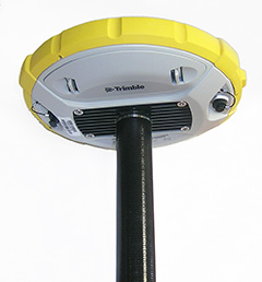
The TrimbleR4sLE GNSS receiver. (Photo: Trimble)
Forensics GNSS Solution. The Trimble Forensics GNSS solution combines the Trimble T10 tablet or TDC100 handheld with the Trimble Forensics Capture software and the Trimble R4sLE GNSS receiver.
The solution enhances forensics fieldwork by improving efficiency and broadening the range of data collection technologies available using the same, proven software. Trimble Forensics Capture software supports GNSS-based workflows and works with the Trimble R4sLE receiver, or any Trimble R-series receivers. Options for data collection now include GNSS, 3D scanners, total stations and unmanned aerial systems.
Forensics Capture field software, designed with the help of law enforcement, uses industry terminology and Wizard-based workflows, making it easy to learn and easy to use.
Built-in ground scaling and local coordinate system for every scene so there is no need for site calibrations.
Integrated surveying workflows for GNSS, Trimble SX10 or total stations.
Storage for all collected data within the same Capture file, including GNSS, total stations or the SX10.
An IP-67 rated Trimble R4sLE receiver, which is protected from dust and capable of withstanding water immersion up to a 1 meter for 30 minutes.
The new solution is expected to available in December 2018.
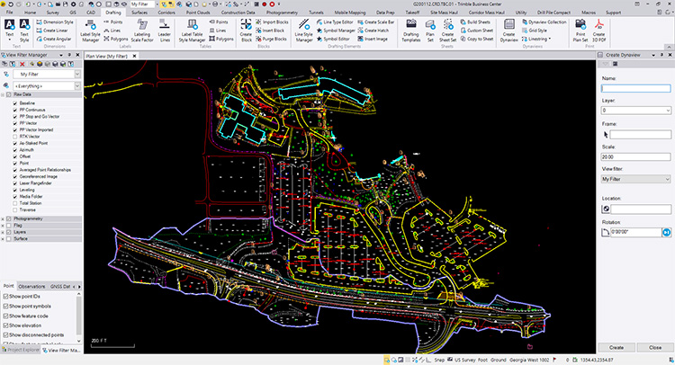
Trimble Business Center v5.0. (Image: Trimble)
New version of Business Center. Version 5.0 of Trimble Business Center merges two products, Trimble Business Center and Business Center – HCE, to provide both surveying and civil construction customers with a complete office software solution. Combining both products into one platform provides a larger set of tools and data interoperability between survey and construction workflows.
New capabilities:
Support for mobile mapping and terrestrial scanning data from systems such as the Trimble MX9 mobile mapping system and the Trimble TX series terrestrial scanners.
Ability to combine high-quality flight data from Delair unmanned aerial systems (UAS) with other sensor data for the rapid creation of vivid orthomosaics and highly accurate surface models. Survey and construction professionals can now integrate these multi-sensor data types within the single software environment.
Intelligent new tools for the creation of computer-aided design (CAD) and geographic information system (GIS) deliverables, corridor inspection reports and tunnel as-built analysis from complex 3D point clouds.
The addition of automated feature extraction, powered by Trimble eCognition software, to dramatically reduce the time to extract features, such as trees, poles and signs, from point cloud data.
New multi-slice capabilities, combined with cutting plane workflows, which allow users to quickly extract cross sections from point clouds at intervals along a linear geometry, further streamlining corridor redesign and maintenance reporting.
Trimble Macro Language (TML), which allows survey and construction professionals to customize data computations and add new CAD and GIS workflows to fit specific local requirements.
New Versions of eCognition Software. Trimble’s eCognition is a software platform for advanced geospatial image analysis for environmental, agriculture, forestry and infrastructure applications.The software extracts accurate geo-information from remote sensing data; eCognition’s intelligent information extraction capabilities accelerate mapping, change detection and object recognition by delivering standardized and reproducible image analysis results.
Updates:
eCognition Suite 9.4 — An improved data management and visualization user interface, algorithms for common feature extraction operations and enhanced 3D data visualization to streamline the development workflow for automatic extraction of valuable information from images and point cloud data. The new capabilities increase the productivity of remote sensing specialists, GIS experts, cartographers, photogrammetrists and geospatial professionals.
eCognition Oil Palm Application 1.3 — A specific solution that provides oil palm plantation managers with valuable information from UAS data that enables them to efficiently manage the plantation. Version 1.3 introduces extended functionality to identify gaps within the plantation to maximize productivity and to enable more sustainable management.
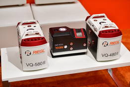
Riegl now offers several new sensors and systems for airborne data gathering at various elevations.
At Intergeo 2018, the company unveiled sensors designed for low-flight altitudes, such as with UAVs. Riegl also introduced sensors designed for medium-flight altitudes used in large UAS/UAV/RPAS with higher payload capacity or in manned helicopters, and scanners and systems for data acquisition at high flight altitudes using manned fixed-wing aircraft.
The Riegl VQ-480II and VQ-580 II on display at Intergeo 2018. (Photo: Riegl)
Medium altitude. The Riegl VQ-480 II (Mark 2) and VQ-580 II (Mark 2) are designed for airborne applications at mid-altitudes for use on both manned and unmanned aircraft. Based on the capabilities of their predecessors VQ-480 and VQ-580, their new, sophisticated designs lead the quality of the systems to a new standard of performance and user-friendliness.
Both offer a measurement rate of up to 1,250,000 measurement/second and a wide field of view of 75 degrees, suitable for corridor mapping, city modeling and applications in agriculture and forestry.
With approximately 10 kg of weight, they are ready for integration into helicopters as well as unmanned UAVs with a higher payload capacity, and are compatible with stabilized platforms and even small hatches.
The VQ-480 II and VQ-580 II are prepared for smooth GNSS/IMU integration, offer interfaces for up to five optional cameras, and are equipped with a removable storage card and an integrated SSD for data storage.
While the VQ-480 II works at a laser wavelength of 1550 nm, the VQ-580 II works at 1064 nm wavelength suited to measure on ice and snow.
Laser scanning. Riegl’s VUX series, focusing on unmanned laser scanning, has also been expanded. With the Riegl VUX-240, a new airborne lidar sensor with less than 4 kg weight and a sophisticated design offering 75-degree field of view is now ready to be integrated on both small manned and larger unmanned aircraft.
The high measurement rate of 1,500,000 measurements/second and a high scan speed of up to 400 lines per second are the basis for high scan efficiency, especially in applications like power lines, railway tracks, pipeline inspection or topography in open-cast mining. Interfaces for an optional GNSS/INS system integration and up to four optional cameras are further convincing key features of the new scanner.
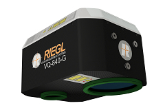
The Riegl VQ-840-G. (Photo: Riegl)
Bathymetry. For the bathymetric segment, the Riegl VQ-840-G has entered the marketplace. Designed for combined topographic and hydrographic surveys for use with large UAVs from lower flight altitudes, the scanner carries out laser range measurements for high-resolution surveying of underwater topography utilizing a green laser beam.
The scanner’s compact, lightweight and robust housing also can include an optional digital camera and an additional, fully integrated infrared laser rangefinder, and is compliant with typical hatches in aircrafts and with stabilized platforms.
The Riegl VQ-880-GII. (Photo: Riegl)
Airborne laser scanning. The Riegl VQ-880-GII is a further improvement of the VQ-880-G topo-hydrographic airborne laser scanning system, offering online waveform processing and full waveform recording.
The improved setup includes a green laser channel, an integrated infrared laser channel, and an integrated dual camera system for RGB and IR. Typical applications include coastline and shallow water mapping, acquiring base data for flood prevention, and measurements for aggradation zones.
Also available are the VQ-780i airborne laser scanner and the VQ-1560i dual wavelength airborne mapping system.
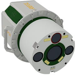
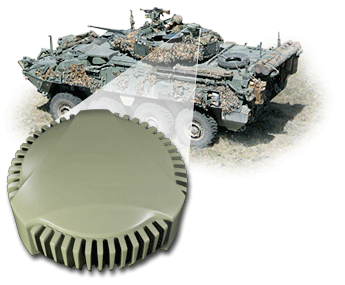
NovAtel’s GPS Anti-Jam Technology (GAJT) now rides into battle and military exercises aboard the Canadian Army’s Artillery Observation Post Vehicles (OPV) that have been fitted with the GAJT‑710ML antenna.
OPVs are highly mobile vehicles that perform observation, reconnaissance and patrolling missions, surveying and acquiring strategic targets and relaying instant, accurate target coordinates acquisition to artillery fire command systems. With their exposed position on the frontlines of the battlefield, OPVs can encounter severe GPS jamming aimed at crippling their capabilities. OPVs require reliable Position, Navigation and Timing (PNT) not only to safely and effectively navigate on the battlefield, but to provide reliable information to artillery in the rear.
GAJT provides protection for GPS navigation and precise timing receivers from intentional jamming in electronic attacks, ensuring that the satellite signals necessary to compute position and time are always available.
“GAJT allows us to have confidence that the position information from the GPS constellation is assured.” said Major Mike Moulton, the project manager in the Directorate of Land Communication Systems Program Management.
NovAtel’s GAJT is a retrofittable system. A military-off-the-shelf (MOTS) product, it comes in versions suitable for land or sea applications and smaller platforms such as unmanned aerial vehicles (UAVs). The antenna works with an array of military and civil receivers, including the Army’s handheld Defense Advanced GPS Receiver (DAGR), other military receivers using SAASM and M-Code, and with civil receivers.
“GAJT scrubs off unwanted signals. It differentiates between what we can recognize as a signal coming from a satellite and something anomalous, which could be interference or deliberate jamming,” explained Peter Soar, NovAtel’s Business Development Manager for defence. “GAJT does not contain a GPS receiver, but works with the receiver that’s already installed. So GAJT faithfully passes the good satellite signals to the receiver which then operates functions such as integrity monitoring in its normal way. GAJT is in use operationally and has been shipped to 16 allied nations around the globe.”
GAJT is a null-forming antenna system that ensures that satellite signals necessary to compute position and time remain available. There is no need to replace the GPS receiver that’s already installed, as GAJT works with both civil and military receivers operating in the GPS L1 and L2 bands. It is ready for M-Code, is a non-ITAR product and is readily available to authorized customers.
Trials with the Canadian Army’s testing unit validated the technology, maintaining access to the GPS signal in an adverse signal environment. It also gave NovAtel engineers a detailed unclassified report on the trial findings and recommendations. The feedback helped NovAtel modify GAJT into a stronger product. The GAJT-710ML antennas were delivered earlier this year, and the Army worked with General Dynamics Missions Systems Canada, the prime contractor for the mission systems on the OPV, to integrate the antenna aboard the vehicle.
“GAJT is a Canadian success story. It is 100 percent produced in Canada and sourced from Canadian components. I think that the Directorate of Land Communication Systems Program Management have shown there is excellent technology in Canada that can be leveraged to meet the Army’s requirements in a very rapid manner,” added Moulton.
This story uses some quotes that first appeared in “Out of a Jam,” an article by Chris Thatcher in Canadian Army Today.