Centum Solutions of Madrid, Spain, introduced its NO JAM ZONE interference detector ION GNSS+ in Miami.
NO JAM ZONE is Centum’s solution for GPS interferences detection and location.
Centum will have a booth in the ION GNSS+ exhibit hall to showcase NO JAM ZONE, as well as and a GNSS simulator to show the process of detection and location of different sources of interference.
Critical infrastructures need to ensure the proper functioning of their radio frequency systems. A good example of this is airports. NO JAM ZONE is a GNSS spectrum monitoring system, capable of detecting interferences that affect the proper functioning of these systems.
NO JAM ZONE works with the most-used GNSS frequencies. Because of its distributed network of beacons, the system is able to give, in real time, the position of a source of interference.
NO JAM ZONE can detect the following types of interference:
Service interruption (jamming)
Spoofing interference
Induced electromagnetic emissions whose power exceeds a certain harmful threshold
Centum also offers the NO FLY ZRONE drone and remotely piloted aircraft system (RPAS) detection and protection system. The active defense system is capable of detecting threats and creating a shield of electronic countermeasures preventing the intrusion of drones in protected areas and diverting them to safe catch areas.
NO FLY ZRONE is effective against the vast majority of drones and RPAS, whether radio-controlled by an operator or by autonomous guidance through GPS. It detects drones and discriminates against those that constitute potential threats.
Once the threat has been classified, NO FLY ZRONE neutralizes the drone control system by taking control of it and driving it to a safe area for its descent and capture; it can also geolocate the operator of the drone.
This announced version of Qualcomm Technologies’ precise positioning framework supports single-frequency GNSS utilizing real-time kinematic (RTK) technology based on the GNSS receiver built into Qualcomm Snapdragon LTE modems and Qianxun SI’s precise positioning technology — all integrated in an automotive-grade LTE module provided by Quectel.
Using Qualcomm 3D dead-reckoning technology, the precise-positioning framework will enable automakers with a comprehensive 3D navigation solution combining multi-constellation GNSS precise positioning, inertial measurement units and other sensors to support next-generation vehicle capabilities, the companies said.
Capabilities include high-performance connected navigation as well as LTE-V2X vehicle-to-everything communications (also referred to as C-V2X PC5 across the globe) for enhanced road safety, improved traffic efficiency and autonomous driving.
Qualcomm Technologies’ precise positioning framework is designed to facilitate open-sky positioning performance from up to 3 meters to less than 1 meter, supporting lane-level positioning and potentially achieving accurate locations from a centimeter to a few decimeters when combined with select third-party GNSS correction services.
This framework is also designed to support a safer and convenient automated driving experiences (level 2 and above), as well as LTE-V2X applications based on positioning, velocity and heading information. Integrated into telematics modules based on the Snapdragon LTE modems, the precise positioning framework supports a cost-effective solution for automakers already including cellular connectivity into their vehicles.
“The efforts with Qualcomm Technologies and Quectel not only assists automakers in addressing the cost and complexities of integrated precision positioning services, but it also aids in creating hardware and service standards for the industry to promote this capability as a public service in the field of connected cars,” said Jinpei Chen, CEO of Qianxun SI. “We look forward to working with Qualcomm Technologies and Quectel to help deliver a solution for higher accuracy and positioning, particularly in dense environments such as in China.”
“In efforts to meet the positioning service requirements of mainstream automakers and Tier 1 suppliers, we felt that working with technology leaders like Qualcomm Technologies and Qianxun SI would be the best to deliver an intelligent, cost-effective and high-quality telematics module,” said Penghe Qian, CEO of Quectel. “The AG35 is our newest generation of automotive-grade modules that enables 4G connectivity and lane level positioning simultaneously, allowing the adoption of LTE-V2X and HD Map technologies on a broad scale.”
“The automotive industry is becoming increasingly dependent on high performance positioning technologies to support connected navigation, safety services and vehicle autonomy,” said Nakul Duggal, vice president of product management, Qualcomm Technologies, Inc. “At Qualcomm Technologies, our proven positioning and system integration capabilities, along with Quectel and Qianxun SI’s solutions, can provide customers with cost-effective precise positioning solutions. We are pleased to be working with China’s leading technology companies like Quectel and Qianxun SI to advance next-generation automotive capabilities that will drive the automotive industry forward.”
As Hurricane Florence rattles along the coastlines of the Carolinas and Georgia creating havoc, everything that flies is grounded. Right now the hurricane has slowed to a tropical storm, but flooding is extensive and people have died.
As soon as the high winds subside, expect almost all first response groups to put up UAVs to begin damage assessment. Digital images gathered by these drones will assist forward personnel to direct recovery and rescue operations. FEMA and other search and rescue teams, already in place along the track of the storm, have begun to rescue people by boat and are expected to fly drones over other inaccessible areas to find survivors.
And, of course, a significant part of the coverage we will see over the next week or so will come from drone-borne TV cameras and links to network uplink vans. We should also expect drones to be used for significant data gathering to map affected areas for damage to homes and infrastructure — including powerlines, radio and cellphone towers and distribution centers, waterways, roads and railways.
Let’s hope that the lessons learned and experience gathered during the major storms of last year will help everyone operating drones assist in minimizing the time to rescue people and to speed recovery from this latest hurricane. Later, expect the insurance companies to arrive with UAVs to assess damage and verify claims.
Police forces are using drones…
The law enforcement office in Dauphin County, Pennsylvania, has been using a drone for several months. With more than 13 investigations completed, the drone has helped locate one lost individual and has also supported crime-fighting.
Rather than calling out a manned helicopter for assistance, the police are able to get a drone in the air within 20 minutes at much less cost.
FAA regulations govern how Dauphin County law enforcement officials fly their drone, including a waiver granted to allow night-time operations.
…while Colombia is testing drones to destroy coca plants.
Recent growth in Colombian coca cultivation to 516,000 acres during 2012-2017 came as a consequence of the end of a government program to fumigate coca fields. Crop-duster planes spraying glyphosate had previously reduced Colombia’s coca fields from 470,000 to 193,000 acres during 2001-2012, according to U.S. figures.
Meanwhile, U.S overdose deaths from cocaine are continuing to increase, while rebels and drug traffickers have apparently shot down several crop-dusters.
Lawsuits against the use of the chemical glyphosate have also been successful. Over-spray is alleged to have killed other, legal crops, and opponents also cited a recent ruling in California that awarded $289 million in damages to a groundskeeper who said glyphosate-based weed killers had caused his non-Hodgkin lymphoma.
Because of concerns, Columbian police have been testing drones — flying a couple of feet above the plants to mitigate over-spraying of defoliants — to kill coca crops and reduce the supply of cocaine. Apparently, 10 remotely guided drones, each weighing 50 pounds fully loaded, destroyed hundreds of acres of coca in the first phase of tests. Though common in agriculture for the monitoring of crop growth, it’s thought that drones have never before been used to kill illegal crops. The fumigation appears to be about 90% effective to date.
Nevertheless, in Colombia’s drug zones, soldiers will be needed to partition swaths of coca-producing land and to defend operators from angry farmers and drug traffickers. There are also land mines which will need to be overcome from Colombia’s long rebel conflict and which pose a danger to drone operators.
Counter UAS (C-UAS) systems are on the rise.
The Drone Dome system uses Laser, RF and Radar. (Photo: Rafael)
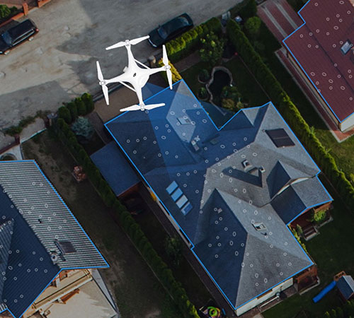
As fast as drone technology is developing, counter UAS (C-UAS) systems are also being put in place to prevent unwanted drones from penetrating the air above sensitive facilities — by detecting and disabling them. There are purportedly more than 60 such C-UAS systems available in the U.S., with more in other countries including China and Russia.
Systems use various technologies for detection — such as radar, laser, optical/IR, RF “sniffer,” and acoustic. Drones can be disabled by RF and GNSS jammers, by spoofing of both the GNSS navigation or the control link, and can be brought down physically by high-power lasers, nets deployed by other drones, collisions by attack drones, by regular or specialized anti-drone gun systems and even by high-pressure water cannons for very close-in defense. Anti-drone systems include detection and take-down dome-based systems and man-portable drone guns.
SpotterRF C-UAV radar. (Photo: UAS Vision)
The UK government has acquired the Drone Dome C-UAS (counter-UAS), manufactured by Rafael, Israel. Detection is provided by an S-band radar (four radars provide all-round coverage), an electro-optical/infrared (EO/IR) surveillance suite, and a wideband RF sensor.
Drones can be disabled by a high-power laser, an RF jammer, or when very close-in by a high-pressure water gun. The UK system is expected to use jamming to bring down drones and doesn’t include the high power “hard-kill” laser option.
Depending on the size of the intruder drone, the radar detection range is around 3.5-10 kilometers, and the radar may also disable a UAV when integrated with the RF jammer. With an active electronically scanned array antenna, the radar is relatively small and light-weight for both fixed and mobile installations.
The DroneGun. (Photo: DroneShield)
Another C-UAV offering, from SpotterRF, claims to solve the problem of requiring multiple radar elements to achieve 360-degree “dome” coverage. The 3D-500 radar enables full “dome-drone” detection from 0 to 90 degrees vertical and 360 degrees horizontal using a single radar with a 500-meter detection radius, yet weighs only 12 pounds.
Latitude, longitude and altitude of intruder targets are measured within a 1-kilometer diameter hemisphere dome. Following radar detection of an unauthorized drone, the system may be augmented by a slew-to-cue optical/IR camera providing a visual display to an operator — a directional RF jammer on a pan/tilt turret can then be activated to take-down the intruder. The system operates automatically to both detect and disable the drone, or manual control is possible to enable initial operator confirmation of the target before take-down is activated.
DroneShield out of Australia markets a drone detection and mitigation system probably best known for its DroneGun. The DroneGun is a point and shoot device able to disrupt multiple RF frequency bands simultaneously (433 MHz, 915 MHz, 2.4 GHz and 5.8 GHz), taking out the communication link to a drone operator — and also GNSS signals when so equipped — up to 1 kilometer away.
The full DroneSentry detection system integrates a suite of sensors and countermeasures including radar, optical, RF listening, acoustic, thermal and an RF countermeasure transmitter with greater power and range than the portable DroneGun.
Another example is the Rex-1 drone gun. Operating in the 2.4 GHz and 5.8 GHz bands, the Rex-1 rifle-like drone-disabling device is a man-portable jammer developed by Russian Kalashnikov Group subsidiary ZALA Aero Group.
https://youtu.be/Px56KtpZ004
Mapping and survey are becoming a major application for drones.
One such example is 3D mapping of a copper mine in only three days using a fixed-wing UAS.
At an altitude of 1,400 meters, the Erdenet open-pit mine in Mongolia extends 5 x 2 kilometers and is more than 200 meters deep in places. Despite strong winds and even some snow in May this year, one UAS quickly captured geospatial data that enabled three-dimensional modeling of the large, complex site.
Site management is expected to use this initial model as a baseline against which future drone-maps will be compared, and to plan future mine operations.
However, extensive preparations over a two-week period were still required, including the installation of 21 ground control points, positioned using GPS RTK measurements. Re-verification of these points was also required from time to time before the survey, due to changes in the mine from ongoing mine operations, including dynamite blasting.
A MAVinci Sirius UAV was used to gather almost 7,000 aerial photographs which were processed through Agrisoft Photoscan Pro software to produce a detailed digital surface model. All the data collected will be used to create various internal views of the mine for continued mining operations. The mine produces about 26 million tons of ore each year, leading to approximately 530,000 tons of copper and 4,500 tons of molybdenum derivatives.
UAVs make medical deliveries.
Some U.S. medical facilities will soon be participating in a Department of Transportation test program to transport medical samples and supplies by UAV — the object being to obtain test results and medical supplies much quicker than at present. Matternet, Zipline and Flytrex — UAV companies already involved in deliveries by drone — will use several different UAVs in the program, which also aims to set up a number of medical distribution centers.
Matternet has been delivering medical supplies by drone in Switzerland, and Flytrex is focusing on food and package deliveries.
Delivery drone in Kasungu, Malawi. (Photo: AFP)
Meanwhile, Zipline and UNICEF have established an “air corridor” in the city of Kasungu in Malawi to test the transport of medical supplies by drone. Rwanda had previously used UAVs to deliver medication in Africa. Other underdeveloped countries without good ground infrastructure could well benefit by using life-saving drone deliveries for urgently needed medication.
Supporting police investigations, mapping of mines, and coca crop destruction all seem to be good examples of newer uses for unmanned air vehicles. And when policing of drone intrusion is required, looks like there are many new options to detect, disable and even take down unwanted drones. I’d say we seem to be making good progress towards better acceptance and that the industry is starting to grow up.
And let’s all hope that the efforts of all first responders in the Carolinas and Georgia continue through the many weeks of recovery from flooding and damage that are still to come, and that people can soon get back into their homes.
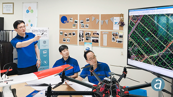
SimActive Inc., a developer of photogrammetry software, has enabled the first government drone mapping project in South Korea.
Asia Aero Survey (AAS), a SimActive regional partner, used Correlator3D for the public survey delivered to the Korean National Geographic Information Institute (NGII) and the Korean Association of Spatial Information, Surveying & Mapping.
While such projects were previously conducted using manned aircraft, a drone was preferred because of the difficulty in accessing the area of interest through traditional aerial and ground surveying methods.
The NGII officially published guidelines for public surveying and mapping with drones in March 2018, with the AAS project being the first delivered and accepted as adhering to the new guidelines.
AAS is also deploying UAV solutions with hyperspectral and lidar for other projects in conjunction with SimActive software.
By Sam Pullen, Stanford University; Jim Kilfeather, Jim Goddard, Tom Nowitzky, Brinda Shah, Wen Doong, David Kagan, and Kerry Greer, Globalstar. To be presented at ION-GNSS+ 2018.
Globalstar is developing a connected car program for continuous, worldwide service to vehicles via satellite and terrestrial communications links.
This combines PPP corrections provided globally by the second-generation Globalstar low-Earth orbit (LEO) constellation with local-area corrections via LTE cellular signals in urban areas for connectivity anytime, anywhere. Both signals are broadcast at 2.4 GHz and include pilot channels used for ranging, augmenting GNSS ranging and providing robustness against jamming and spoofing.
The program provides enhanced navigation via continuous augmentation of GNSS with data derived from ground-based reference networks for sub-meter accuracy and integrity bounds on navigation errors to probabilities as low as 10-9 per operation. When this is combined with other on-board sensors and data such as lidar, radar, optics and IMUs, it will be possible to operate autonomously under almost all conditions with a very high degree of safety.
The key is combined use of PPP corrections globally and local-area CDGNSS/RTK corrections in high-density urban regions where it is economically beneficial. Both sets of augmentations are made available to vehicles. The global approach on the left side of the figure is primary, given its near-worldwide coverage based on the LEO satellite network broadcasting corrections within its licensed communications spectrum at 2.4 GHz. The P/N-modulated pilot component of the Globalstar satellite signals will be used for ranging to augment GNSS and provide additional robustness to RF interference or spoofing at GNSS frequencies.
Spry Drone briefly submerges under water to flip on its belly then fly in the air like a bird (PRNewsfoto/Urban Drones)
SwellPro USA and Urban Drones have released a waterproof drone, the Spry, that can briefly submerge like a submarine, float like a boat and fly in the air at over 43 mph.
The Spry features a self-contained camera that can capture video at 30 frames per second and pictures at 12 megapixels. According to the company, the Spry gives users the ability to capture high-resolution video and pictures without compromising speed and agility. It can also wirelessly transmit the video signals to a monitor embedded in its waterproof remote control.
The Spry’s GPS can be activated from the remote control, which has an integrated 4.3-inch monitor to view the Spry’s live video feed. It also boasts advanced flight features, such as hold position, auto follow, object orbit and return to pilot’s position.
“The Spry’s ability to submerge under water and fly in the air makes it the most versatile drone ever created,” said Alex Rodriguez, CEO at Urban Drones. “We’ve only seen this in science fiction movies.”
Urban Drones is a drone technology company located in Florida and SwellPro USA’s partner in the Spry project.
3DR, makers of Site Scan, has partnered with Esri to develop Site Scan Esri Edition, a custom version of its iOS app for drone flight planning and data capture that works seamlessly with Esri’s ArcGIS Online and Drone2Map for ArcGIS.
The Site Scan Esri Edition app will complement Esri’s Drone2Map for ArcGIS software by providing full drone project mission planning and a simple workflow for transferring drone captured data into the Esri ArcGIS ecosystem.
Screenshot: 3DR and Esri
Users will be able to connect to ArcGIS Online with an Esri sign-in. The app will allow users to directly use Esri data layers from ArcGIS Online — including custom data layers from the user’s FedRAMP authorized ArcGIS Online organization account — as base and reference data for their drone flight planning mission.
Esri customers can use any drone currently supported by Site Scan, including a variety of DJI drones. Site Scan also supports a custom version of the new Yuneec H520 commercial drone by 3D, which is based on the Dronecode PX4 software and designed to be an open and secure drone option for use on U.S. government projects.
“I’m thrilled that we’ve been able to work with Esri to provide its users with flight planning and drone capture tools,” said Chris Anderson, CEO of 3DR.
“3DR has been a leader in the drone industry, and we are excited to support this development effort,” said Cody Benkelman, imagery product manager at Esri. “A drone flight planning app that connects directly to ArcGIS Online will provide great value to Esri’s worldwide customer base, and simplify the process of ensuring successful projects using Drone2Map.”
Site Scan Esri Edition app will be available on the Esri Marketplace in late September for free to ArcGIS customers.
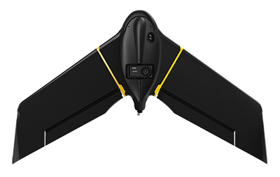
SenseFly, provider of fixed-wing drones, has launched the eBee X for mapping.
The eBee X, part of the Parrot Business Solutions portfolio, is designed to boost the quality, efficiency and safety of an operator’s geospatial data collection.
The eBee X. (Photo: senseFly)
It offers a camera to suit every job, the accuracy and coverage capabilities to meet the requirements of demanding projects, and is durable enough to work virtually every site, the company said.
“The eBee X is a giant leap forward for mapping technology and underscores senseFly’s position as the leader in the fixed-wing drone market,” said Gilles Labossière, executive vice president and COO of Parrot Group and senseFly CEO. “No matter what type of project a professional is undertaking, the eBee X has the coverage, data and accuracy capabilities needed to get the job done.”
The eBee X includes a range of cameras for jobs ranging from land surveying and topographic mapping to urban planning, crop mapping, thermal mapping, environmental monitoring and more. Cameras include:
The senseFly S.O.D.A. 3D: a unique drone photogrammetry camera with a one-inch sensor, which changes orientation during flight to capture three images (two oblique, one nadir) every time, instead of just one, for a much wider field of view. The result is stunning digital 3D reconstructions in vertically-focused environments—such as urban areas, open pit mines and coastlines—over larger areas than quadcopter drones can achieve. senseFly S.O.D.A. 3D is optimised for quick, robust image processing with Pix4Dmapper software.
The senseFly Aeria X: a compact drone photogrammetry camera with APS-C sensor. This rugged innovation offers an ideal blend of size, weight and DSLR-like image quality. Thanks in part to its built-in Smart Exposure technology, it provides outstanding image detail and clarity, in virtually all light conditions, allowing operators to map for more hours per day than ever before.
The senseFly Duet T: a dual-camera thermal mapping rig, which lets mapping professionals create geo-accurate thermal maps and digital surface models quickly and easily. The Duet T includes both a high-resolution (640 x 512 px) thermal infrared camera and a senseFly S.O.D.A. RGB camera with one-inch sensor. Both image sources can be accessed as required, while the rig’s built-in Camera Position Synchronisation feature works in sync with Pix4Dmapper photogrammetry software (optional) to simplify the map reconstruction process.
The eBee X is also compatible with the Parrot Sequoia+ multispectral camera for agriculture, the senseFly S.O.D.A. drone photogrammetry camera and senseFly Corridor for simple linear mapping.
The eBee X can meet the exacting requirements of every project. Its unique Endurance Extension option unlocks a flight time of up to 90 minutes (versus a maximum endurance of 59 minutes by default).
With this capability activated, the drone is able to achieve vast single-flight coverage of up to 500 hectares (1,235 acres) at 122 meters (400 feet), while the eBee X’s built-in High-Precision on Demand (RTK/PPK) function helps operators to achieve absolute accuracy of down to 3 centimeters (1.2 inch) — without ground control points.
According to senseFly, the eBee X allows users to work virtually every site, no matter how demanding, thanks to the drone’s built-in Steep Landing technology, ultra-robust design, live air traffic data and more, all backed by senseFly’s professional, localized support.
The eBee X is ideally suited to the varied and evolving needs of mapping professionals. These include: surveying and construction companies, quarry and mine operators, agronomists and forestry engineers, professional drone service providers, aerial imagery companies, environmental researchers and more, the company added.
The eBee X is supplied with senseFly’s eMotion flight planning and data management software.
A roundup of recent products in the GNSS and inertial positioning industry from the September 2018 issue of GPS World magazine.
OEM
Reference receiver
For real-time networks (RTN)
Photo: Trimble
The Trimble Alloy GNSS reference receiver is designed for continuously operating reference stations (CORS). It offers 672 channels and constellation tracking of GPS, GLONASS, BeiDou, Galileo, QZSS, IRNSS and SBAS for robust and reliable reference data. With an IP68 rating for protection against dust and moisture, the Alloy performs in rugged environments to meet the demands of professionals in earth science, surveying, construction, mapping and agriculture. The Alloy allows RTN owners and operators to track and log all current and planned GNSS and deliver absolute position monitoring, as well as centimeter-level accuracy in real time with Trimble RTX precise point positioning technology. Featuring a four-line OLED screen, the receiver displays key information without the need to scroll through multiple menus. Other features include dual hot-swappable batteries, multiple power inputs and serial ports, Wi-Fi connectivity and remote access options.
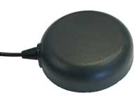
The TW7875 magnetic-mount GNSS antenna is designed for precision dual-frequency positioning. It is capable of receiving GPS L1/L5, GLONASS G1, BeiDou B1, Galileo E1/E5a and NavIC L5. It employs Tallysman’s Accutenna technology, which provides superior multipath signal rejection due to its low axial ratio across the full bandwidth. It also provides a linear phase response and tight phase-center variation. It is designed for precision agriculture, autonomous vehicles and other precision applications. The TW7875 is housed in a magnetic-mount IP67-rated housing, but can also be mounted with screws or adhesive tape. The embedded version, Model TW3875, has a wide selection of connectors and custom cable lengths, and can be custom tuned by Tallysman to ensure optimum performance within the customer’s enclosure.
The SPAN CPT7 provides tightly coupled GNSS+INS navigation technology in a rugged, compact unit. Commercially exportable and designed for integration into a wide variety of applications, it delivers assured positioning anywhere. SPAN technology tightly couples GNSS and inertial navigation system (INS) measurements. The system enables continuous, robust positioning and fast reacquisition in challenging navigation environments where GNSS signals may be unreliable or unavailable for short periods. Dual antennas deliver instant alignment. NovAtel’s OEM7 Interference Toolkit (ITK) provides interference detection and mitigation, with the spectrum analysis function allowing integrators to identify interference within the GNSS frequency bands and implement digital filters to eliminate the problem.
The commercial-off-the-shelf (COTS) LN-200C is a compact and lightweight six-degrees-of-freedom inertial measurement unit (IMU) that can be used for instrument stabilization, motion compensation and navigation in commercial, aerospace and industrial applications. Based on fiber-optic gyro (FOG) technology, the LN-200C IMU’s hermetic seal and lack of moving parts help to ensure low noise and extended operational life. The LN-200C can serve as a drop-in replacement for applications that don’t require the full operational range of the original LN-200 and that can benefit from the expedited licensing and global ease of use offered by the LN-200C.
Global Certification Forum (GCF) protocol conformance tests available
Photo: Rohde & Schwarz
The Rohde & Schwarz CMW500 wideband radio communication tester and SMBV100A GNSS simulator have been expanded to support Global Certification Forum (GCF) protocol conformance tests for C-V2X device certification. Utilizing the Qualcomm 9150 C-V2X chipset from Qualcomm Technologies, the R&S CMW500 acting as an LTE network simulator allows automakers to test C-V2X direct communications (PC5) according to GCF Work Item 281. The new R&S CMW-KK550 test package includes the 3GPP Protocol Conformance tests from LTE-V2V GCF Work Item 281 and LTE-V2X GCF Work Item 282. The R&S CMW-KU514 C-V2X software package on the R&S CMW500 is used to verify data transmission and reception over the PC5 interface in ideal, faded and congested channel conditions. Together, both packages enable Rohde & Schwarz to support C-V2X device testing through all protocol layers.
The Multimax FV family is available in a range of configurations, supporting multi-constellation GNSS. The antennas also support up to dual MIMO LTE (including Band 14 for the FirstNet public safety network), 3×3 MIMO Wi-Fi or 2×2 MIMO Wi-Fi. With a small footprint and a strong, bolt-mount aluminum base, the Multimax FV family provides protection against natural hazards threatening vehicles, including vibration, ice, salt, car washes and tree sweeps. The high-gain antennas deliver a large cellular footprint alongside high-rejection GNSS technology (GPS, GLONASS, Galileo and BeiDou).
For Beyond Visual Line-of-Sight (BVLOS) flight operations
Arctic UAV has adopted Kongsberg Geospatial’s IRIS UAS Airspace Awareness application for BVLOS operations within Canada’s Arctic. IRIS provides simultaneous monitoring of multiple drones. It offers real-time calculation of aircraft separation and communications line-of-sight, real-time visualization of track and weather data.
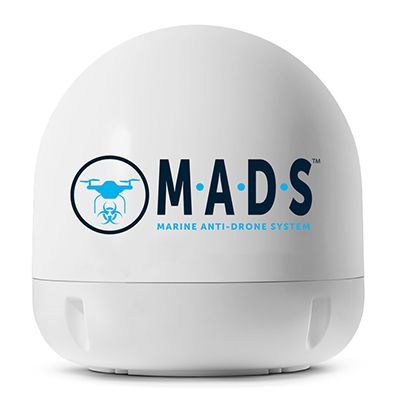
M.A.D.S detects and identifies commercial drones within a 5+ kilometer range, providing GPS positioning of both drone and pilot together with the drone’s speed and heading. Once a drone threat is established, the system enables a 500-meter electronic exclusion zone to be created around the yacht. Should the drone approach this exclusion zone, its control/video signal is blocked, initiating a fail-safe mode and forcing a landing or return to operator.
Operates on the Wave Relay mobile ad hoc network (MANET)
The Auto-Tracking Antenna System is a portable ground-to-air antenna for tracking aircraft, including drones. Defense customers can use it for better airborne communications relay and full-motion video camera/sensor data transmission. It can be assembled and deployed in less than 15 minutes.
Version 6 of Virtual Surveyor drone surveying software offers a faster, more efficient workflow and better user experience in a more stable platform than previous versions. Along with new capabilities is an improved licensing system and an extended free application. The software generates an interactive onscreen environment through orthophotos and digital surface models generated from a UAV, where the surveyor selects survey points and breaklines to define the topography. It enables land surveyors to complement traditional fieldwork with UAV imagery to generate highly accurate topographic products.
Foresights is a risk management and geospatial analytics platform designed to help clients manage forestry assets quickly, effectively and accurately. Foresights identifies areas of new or potential risk, and delivers operations tracking and forest damage management services. It combines satellite imagery, topography maps, soil maps, meteorological data and near real-time ground input from operational teams to deliver optimized insights. It can detect damage as small as 0.1 hectare (0.25 acre) from pests, disease and drought.
EOS Platform provides a powerful toolset for geospatial analysts — offering search, analysis, storing and visualization of large amounts of geospatial data. Image data obtained from LandViewer or uploaded from a user’s computer is stored in cloud-based EOS Storage and is instantly available for remote-sensing analysis or image processing. EOS Processing offers 16 workflows that run online, including raster tools, remote sensing analytics, photogrammetry and proprietary feature extraction algorithms designed by EOS engineers and data scientists to address the main challenges of agriculture, forestry, oil, gas, retail, city planning, defense and other industries.
The Esri book GIS for Surface Water: Using the National Hydrography Dataset by Jeff Simley details how to use geographic information system (GIS) technology to visualize and analyze data sets. Simley is an award-winning cartographer and the former lead of the hydrography program at the United States Geological Survey (USGS). The book examines the complexities of surface water systems and shows readers how to use the Esri ArcGIS software with government water data sets to better study and manage the United States’ vast water system.
EOMAP has opened a commercial online store for global shallow-water bathymetry derived from satellite data. At the store, EOStore Bathymetry, customers can search for and request high-quality data. Satellite-derived bathymetry (SDB) is a valuable tool for the surveying, planning and management of coastal and offshore sites. SDB can provide shallow-water bathymetric data worldwide without the need for a physical presence in the area of interest. EOMAP developed the bathymetry store in response to industry feedback. EOStore Bathymetry offers different horizontal spatial resolutions of the bathymetric grid of 2 to 15 meters, making the data suitable for surveying as well as planning and modeling purposes.
Drone company PrecisionHawk has announced a partnership with EagleView, a provider of aerial imagery and data analytics for government, insurance and commercial sectors.
PrecisionHawk also announced that it has purchased both HAZON Inc. and InspecTools Inc., businesses that specialize in the delivery of inspection services and technology for the energy industry.
Both companies bring demonstrated expertise to enable tighter integration between the collection and the analysis of drone data, PrecisionHawk said. Paul Bingaman, CEO of InspecTools, and David Culler, CEO of HAZON, will join PrecisionHawk’s executive leadership team.
EagleView partnership for insurance claims
EagleView’s partnership with PrecisionHawk enables drone insurance inspections. (Photo: PrecisionHawk)
Through the partnership with PrecisionHawk, EagleView will collect at-scale insurance claims imagery via drones by leveraging PrecisionHawk’s global network of drone pilots, Droners.io.
The addition of PrecisionHawk’s drone pilot network will benefit EagleView OnSite Solutions for remote claims inspection. EagleView OnSite virtual desk adjustment combines imagery from multiple sources, including drones, with a variety of data analytics and reports to enable adjusters to efficiently triage claims, virtually inspect properties from their desk, and ultimately close property and casualty (P&C) claims faster.
“EagleView OnSite provides insurance customers with all the tools necessary to settle claims without ever going into the field,” said Rishi Daga, CEO of EagleView. “As drones transform the way the insurance industry operates, making inspections safer, easier and more cost effective, EagleView reinforces its commitment to drone technology to digitize manual workflows.”
Virtual drone inspections for insurance claims address a challenging trend in the P&C insurance industry. Over the past 20 years, the number of experienced insurance adjusters has dropped dramatically, causing labor shortages — especially after major storms hit. The demand for insurance adjusters is high, yet drone pilots add a new, untapped “labor force” to the equation.
Combining the EagleView OnSite virtual desk adjustment solution with PrecisionHawk will offer the insurance industry thousands of certified, trained drone pilots to perform high-quality insurance inspections at a competitive cost. With more than 25,000 claims processed by EagleView OnSite in the last 18 months, EagleView can help insurance carriers transform their property claim workflows and decrease cycle time by at least 40 percent to best serve their customers after a catastrophic natural disaster.
Drone technology and analytics for the energy market
HAZON brings extensive aviation experience, standards-based operating procedures, certified drone flight operations and inspection services, widely regarded as the best in the energy industry, to the PrecisionHawk team. The company has delivered more than 13,000 inspections totaling over 8,000 hours of flight time, with a majority focused in energy markets for Fortune 500 utilities.
InspecTools brings high-fidelity machine vision software and data analysis tools built for the renewable energy market. Their market-leading software for both solar-panel and wind-turbine inspection is utilized by some of the largest equipment manufacturers and service providers in the world. Customers like Vestas, PG&E and SMA Solar rely on InspecTools’ sophisticated reporting, analytics and machine learning capabilities.
“We’re very pleased to bring together the established technology and multi-market reputation of HAZON and InspecTools with PrecisionHawk’s experience, team and expanded portfolio,” said Michael Chasen, CEO of PrecisionHawk. “By combining these offerings, our customers will have access to extensive and leading-edge energy products and services, regulatory expertise and a record of safe, secure and compliant operations.”
Thanks to advances in technology and regulations, the energy market has quickly moved from experimenting with pilot projects to large scale deployment of drone solutions, PrecisionHawk said. Across distribution lines, transmission lines, solar panels, wind turbines, oil and gas and utility infrastructure, and emergency response, energy presents a current global market opportunity of $9.7 billion.
According to IDC, worldwide spending on robotics and drones will accelerate over the next four years reaching $201.3 billion in 2022. While the value is clear across time, safety improvements and operational efficiency, scaling and managing a drone program can be complex.
“HAZON is excited to bring our world-class best practices and reputation for standards-based operations and safety to the PrecisionHawk team,” said Culler. “By joining PrecisionHawk, our customers gain access to the next level of technological sophistication for more scalable, predictive and cost-efficient drone solutions that drive better business intelligence.”
“InspecTools brings years of experience, analytics tools and machine vision software for renewable energy that is an immediate value-add to PrecisionHawk’s software analytics platform,” Bingaman said. “This relationship further enhances the technologies and services that are fundamental to advancing the economic potential of drones in the energy market.”
The acquisition of HAZON and InspecTools underscores PrecisionHawk’s strategy to operate in high-growth markets and accelerate the adoption of commercial drones.
The acquisitions, which are subject to customary closing conditions, are expected to close later this month.
Conducted online in July 2018, the GPS World State of the GNSS Industry survey compiled detailed answers to 30 key questions from 273 respondents, spread across six continents.
Prominent insights gained, and outlined in these pages: the PNT sector is booming, as opportunities outnumber obstacles; well-trained engineers are at a premium; and the Internet of Things is the newest market driver, perhaps the most powerful yet.
As precision guidance, autonomous operations, high-definition geocoded images and high-volume data processing all improve, drone use will continue to increase. OEM receiver manufacturers, sensor suppliers and data-handling companies play key roles in development, and stand to profit thereby.
In particular, use of drones is growing in land management, construction, mining, and farming. An open-pit mine operation can be supported through detailed drone inspection producing high-resolution images. Processed images and data enable keeping tabs on inventory, site changes over time, identifying best areas for further extraction, and monitoring and managing vehicle movement. These tasks required huge amounts of time in the past. Drone overflight and processing tools condense all the effort as well as producing enhanced results to enable faster and clearer decision-making.
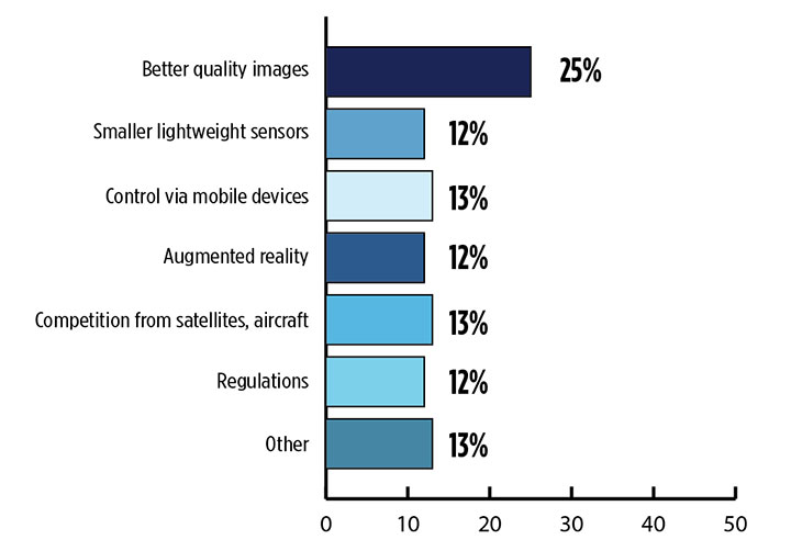
What is the biggest challenge for the UAV industry? (Source: GPS World 2018 State of the Industry survey)
Defense. Surveillance and reconnaissance are probably the biggest military drone applications. Carrying payloads that include color video cameras and infrared night vision cameras, more than 19,000 drones are now in the arsenal of the U.S. Army, Air Force, Marines and Special Ops, and more have gone to other nations’ militaries.
Flying at relatively low altitude, with somewhat limited range and powered by a single quiet electric motor, these drones have become essential in gathering forward-situation intelligence.
Other UAV craft provide higher altitude, longer-duration surveillance and reconnaissance over wider range: up to 20 hours, up to 15,000 feet, more than 60 miles afield. Civilian versions of these craft are in development.
Delivery. Respondents to our survey thought delivery will be a breakthrough application for drones. Amazon has several trials running globably. National civil aviation authorities need to move forward with plans to integrate drones into civilian airspace for this initiative to graduate to full-scale operations and achieve their objective of 30 minutes from order to delivery.
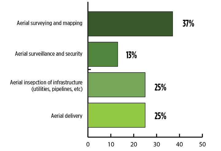
What is the killer app for drones? What professional UAV market sector will most powerfully drive adoption and influence new regulations for unmanned aerial vehicles? (Source: GPS World 2018 State of the Industry survey)
Precision Agriculture. One of the most significant applications which seems to be missing from survey responses is agriculture. Both quadcopters and hybrid fixed-wing/copter drones are in widespread use to capture image data overflying crops, and then process the data and build crop analytics. Graphic results point to how crops can be managed to increase yield.
Making this work is a combination of sensor payloads gathering visual, video, lidar, thermal and hyperspectral data; the secret sauce lies in how the data is processed and presented to farmers. Emphasis is placed on exactly how “green” crops appear when inspected by the various sensors. A number of companies offer services for farmers to optimize crop management.
All these areas are show significant drone growth. Let’s not forget facility, transmission line and pipeline inspection — tasks where drones excel at increasing efficiency and decreasing costs.
For more results from the 2018 State of the GNSS Industry, see this page.
Tony Murfin is a GNSS aerospace consultant with several decades experience at leading companies in the GPS/aviation and OEM sectors.