Firefighters in Slovenia. (Photo: tomazl/E+/Getty Images)
Public Safety Communication Europe (PSCE) and the European Space Agency (ESA) have signed a Memorandum of Intent (MoI) to support the use of satellite applications for public safety.
ESA and PSCE will work together under the new MoI towards establishing interoperable public safety communications systems.
The MoI will support the emergence of space-based applications in the public-safety domain such as public safety services relying on secure mobile broadband communication solutions. These include applications within disaster preparedness, response and resilience, situational awareness, assessments of damages, navigation-based services for tracking and coordinating rescue forces on-site and for emergency vehicles.
“ESA Space Solutions and the 4S Strategic Programme Line will support through this agreement the emergence of solutions making use of secure satellite communications for institutional public safety user communities,” said Rita Rinaldo, ESA. “This can be achieved as of today through existing satellite telecommunications infrastructures. In the future it will be possible to make use of new and innovative infrastructures with enhanced capabilities. Early pilots and demonstrations will showcase the unique benefits granted by satellites to the user communities and early adopters.”
“The cooperation with ESA will help to explore complementary solutions that will contribute to cover capability gaps and needs for public safety. It is of extreme importance to improve public safety communication systems with cutting-edge and rapidly deployable solutions that will facilitate PPDR missions,” explained Marie-Christine Bonnamour, PSCE.
The first step for ESA and PSCE cooperation will be PSCE participation in ongoing user studies on “Satellite Applications for Public Safety.” PSCE will help identify the needs of public safety stakeholders such as emergency services, fire brigades and law enforcement.
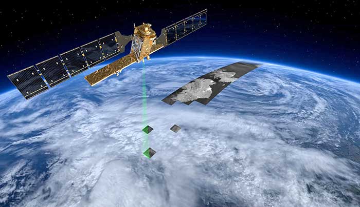
In a first for any satellite navigation system, Galileo has achieved a positioning fix based on open-service navigation signals carrying authenticated data. Intended as a way to combat malicious spoofing of satnav signals, this authentication testing began at ESA’s Navigation Laboratory — the same site where the very first Galileo positioning fix took place back in 2013.
These historic first authenticated signal position, velocity and timing fixes were made using a total of eight Galileo satellites for around two hours on Nov. 18. The tests represent a first proof of concept for an eventual operational service offering positioning with authenticated data to users.
Spoofing has, for instance, been demonstrated as a means of forcing down drones or redirecting ships, while some high security locations — as well as disrupted international borders — have become notorious for spoofing signals that prevent the reliable use of satnav in their vicinity.
The Galileo Control Centres send the navigation signal to the GSC for the addition of the authentication code, which is then returned for uplink to the satellites.
“When a receiver picks up a navigation signal from a satellite, up until now it has no way of confirming that was indeed its source,” said navigation engineer Stefano Binda, overseeing the project for ESA. “This can result in spoofing — malicious people and organisations using false signals to mislead users about their actual position. This authentication service offers a way to prevent such deception.”
“In recent years, this problem has become sufficiently pronounced as a weak point that the European Commission, ESA and European GNSS Agency (GSA) decided to develop signal authentication as a differentiator for Galileo,” Binda said.
An ESA Navigation Directorate team at the Agency’s ESTEC technical centre in the Netherlands worked with its GSA counterparts at the twin Galileo Control Centres (GCCs) in Italy and Germany and the Galileo Service Centre (GSC) in Spain. “In everyday authentication you might send a document that has been digitally signed, where both sender and recipient use compatible cryptographic keys to validate the document’s source of origin,” Binda said.
“In this case we were working with a constrained amount of bandwidth within the navigation signal, so instead opted for a ‘delayed key’ approach. This means the initial data come along together a short tag which, within a short stretch of time usually not exceeding 30 seconds, is followed by a key, which is able to validate the tag and authenticate the data associated with it.”
During the test campaign, the Galileo Control Centres send the navigation signal to the GSC for the addition of the authentication code, which is then returned for uplink to the satellites, to be received and authenticated by the test receivers at ESTEC’s Navigation Lab and elsewhere in Europe, in participating laboratories.
To enabled the authentication test campaign, Thales Alenia Space in France served as prime contractor to upgrade of the Galileo Mission Segment — the world-spanning system that determines and create the navigation messages broadcast by Galileo satellites. Thales Alenia Space in Italy was responsible for the system level integration.
No modification of onboard satellite systems has been required to support Open Service Navigation Message Authentication (OSNMA), as spare bandwidth was made use of.
“We used our standard laboratory Septentrio test user receivers with a software add-on,” Binda said. “The beauty of this approach is that receivers will be able to make use of the future authenticated service without needing any new hardware, only software updates — apart from additional measures that might be mandated for operation in practice.”
ESA and GSA are continuing their authentication testing, with a view to introducing an operational Open Service Navigation Message Authentication service for users in the near future.
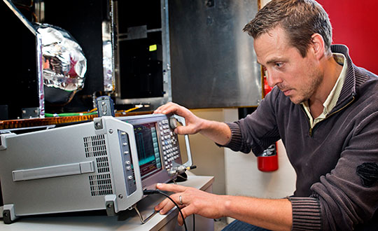
ESA’s Radio Frequency Systems, Payload and Technology Laboratories perform RF research for both the space and ground segments. (Photo: ESA)
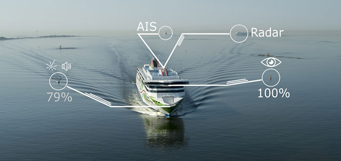
A day of ferry trips between Finland and Estonia became some of the best documented voyages in maritime history. Cameras, sensors, radio and satellite navigation receivers and even microphones recorded every instant of the crossings over the Baltic, gathering raw data for a new ESA-led project applying artificial intelligence (AI) to the situational awareness of shipping — as an important step to full autonomy.
The Tallink shipping company’s new 212.2 meter-long Megastar passenger and car ferry was fitted with data-gathering devices for its sailings on the busy stretch of sea between Helsinki and Tallinn.
The testing was overseen by a team from the Finnish Geospatial Research Institute (FGI) for an ESA project called Artificial Intelligence/Machine Learning Sensor Fusion for Autonomous Vessel Navigation, or Maritime AI-NAV.
“Our aim is to show how AI can be applied to achieve autonomous situational awareness, so that a ship can reliably sense its own environment,” said FGI’s Sarang Thombre.
Photo: European Space Agency
“Such autonomous systems would initially be deployed in support of human crews, for enhanced safety and efficiency – with crewless ships a much longer-term goal.
“The most experienced human ship captains will have the least trust in any single navigational device but will rather continuously cross reference between them. Similarly, our autonomous functionality will not be overly reliant on a single data source but combine and verify data from multiple sensors.
“Having gathered many gigabytes of data during our initial August field campaign, then again in October with more days planned in December, we are applying the results to train and test our data-fusing algorithms. A follow-up seagoing test will then verify their performance in practice.”
The Maritime AI-NAV team plans to employ a variety of sensor types, including satellite navigation receivers – also utilizing of Europe’s Galileo system — monocular and stereo cameras, standard radar, “laser radar” lidar and an array of microphones, along with “Automatic Identification System” radio signals. These AIS signals transmit position, size and routing information of all vessels above a certain class, as well as fixed infrastructure such as oil rigs or wind turbines.
“Satellite navigation lets the ship know where it is in the sea, while the other sensors let it know what is around it, which is essential for identifying and avoiding any obstacles,” Thombre said. “The different data sources operate across a variety of ranges — so radar and AIS provide longer range detection out to the horizon, while cameras and lidars come into their own at shorter distances. Plus we had a trio of microphones aboard the Megastar, determining the angle of arrival of sound from other ships. The challenge now is to fully integrate all these sources using machine learning, to build up a holistic picture.”
Maritime AI-NAV is supported through ESA’s Navigation Innovation and Support Programme, working with European industry and academia to develop innovative navigation technology.
FGI is joined in the Maritime AI-NAV consortium by Aalto University’s Sensor Informatics and Medical Technology group and maritime IT startup Fleetrange.
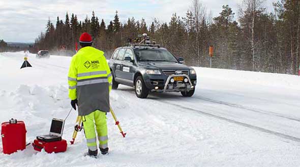
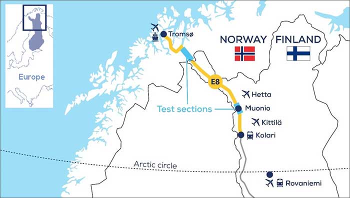
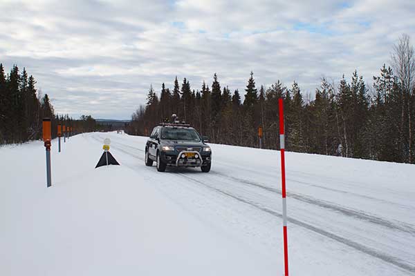
An ESA-supported project is testing autonomous vehicles on an intelligent road in Lapland, Finland.
Known as Snowbox, this 10-km stretch of forest-lined roadway on Finland’s E8 highway has been specially equipped for autonomous driving tests, ESA said. Containing cameras, “laser radar” lidar, ultra-wideband antennas and reflective panels, the road itself is underpinned by power and fibre optic lines, and embedded with pressure sensors to record road surface conditions and the speed and type of vehicles driving along it.
Known as Snowbox, this 10-km stretch of forest-lined roadway on Finland’s E8 highway has been specially equipped for autonomous driving tests, including FinnRef GNSS reference stations, as seen here. (Photo: ESA)
“If autonomous vehicles can drive well here, they can drive almost anywhere,” said Sarang Thombre of the Finnish Geospatial Research Institute, who’s managing the Arctic-PNT project. “Our project aimed at ensuring in particular that the precise positioning required by autonomous systems was available here, to establish this test site is indeed somewhere that driverless vehicle manufacturers should employ for testing. We carried out experiments with a robotic car over two successive seasons to show that the necessary precise positioning, down to 20 cm, is indeed accessible.”
Snowbox is also linked to the FinnRef network of satellite navigation reference stations, to deliver corrections for precise satnav positioning. By performing positioning measurements continuously at fixed locations, these reference stations serve as a standard, allowing the identification of measurement errors to boost positioning accuracy on a localized basis, ESA added.
Snowbox map. (Photo: ESA)
“The Arctic is a difficult environment for autonomous driving in general,” Thombre said. “Signal disturbance due to the ionosphere, the electrically charged layer of the atmosphere, degrade satellite navigation performance. This effect is more pronounced in the Arctic region. And satnav augmentation systems also face challenges.
“Because their signals are broadcast from geostationary satellites, they are only viewable here at an elevation of up to 10 degrees above the horizon. And mobile coverage — useful for providing correction data from reference networks — is also inconsistent.
“In addition, possibility of mists and fog, snowstorms and rainfall make it difficult for cameras and lidar, while ice and snow on the road means wheel speed sensors may slip. And temperatures that can plunge down to below -30°C can impede the performance of electronics.”
The Arctic-PNT team’s testing was based around a robotic car crammed with sensors and recording equipment. Called Martti, the vehicle was supplied by Finland’s VTT Technical Research Centre.
Snowbox test roadway. (Photo: ESA)
“While Martti is capable of autonomous driving, we drove it manually,” Thombre said. “We were using it to capture all the data we needed. We started off using solely satellite navigation – including Europe’s Galileo and EGNOS – progressively adding more and more augmentation data, including in-car sensors, and corrections from the FinnRef stations, to reach the all-important precise positioning threshold of 20 cm.
“To access the FinnRef corrections from the car systems we tested out various mobile sim cards. Adding to the challenge, we crossed an international border, because part of the E8 highway is instrumented on the Norwegian side as well — called Borealis.”
The Snowbox infrastructure was established along the E8 because, while it is a remote roadway it is also economically important, with trucks heading south from Arctic fisheries.
The Arctic-PNT test campaigns, starting from 2018, gave a positive bill of health to the Snowbox, which is available for experiment campaigns. The campaigns were supported through ESA’s strategic initiatives for the Arctic region.
Feature image: The Arctic-PNT team’s testing was based around a robotic car crammed with sensors and recording equipment. Called Martti, the vehicle was supplied by Finland’s VTT Technical Research Centre. (Photo: ESA)
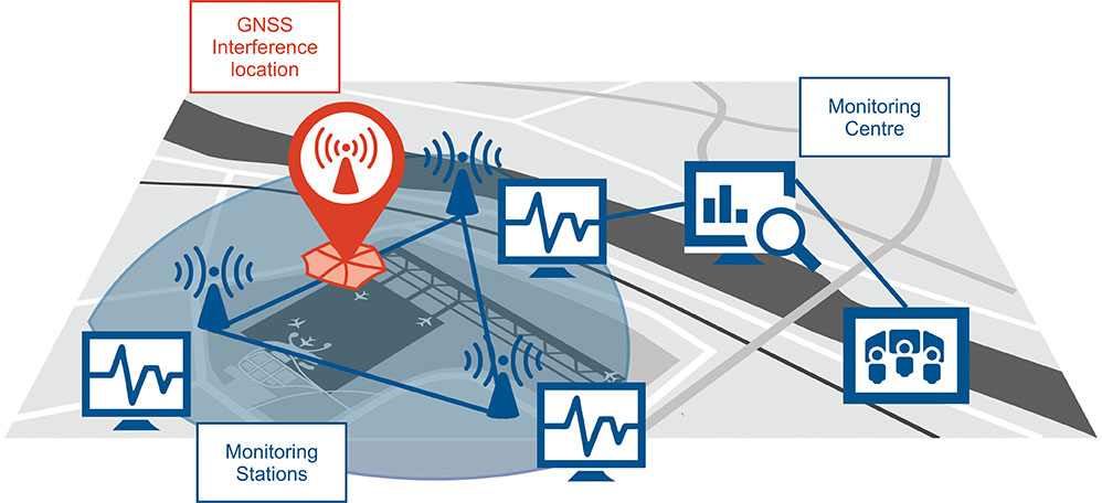
Schematic of the GNSS interference detection and analysis system GIDAS. (Image: OHB Digital Solutions)
In September 2020, the first GIDAS monitoring stations were installed at the Czech airport in Brno.
GIDAS — GNSS Interference Detection and Analysis System — enables continuous 24/7 monitoring of the GNSS frequency bands within a defined region to automatically detect, classify and localize intentional interference from jamming and spoofing.
GIDAS can raise the alarm in real time, identify the type of interference, and then pinpoint the location of these dangerous portable devices causing the interference so the authorities can take immediate remedial action. It considerably improves safe and robust operation of GNSS receivers, terminals and applications.
GIDAS was developed by OHB Digital Solutions and Joanneum University of Applied Sciences through ESA’s Navigation Innovation and Support Programme (NAVISP).
The system works autonomously and is designed to be easily deployed. It is scalable and flexible; it can be used as a standalone monitoring station or upgraded to a network of stations.
Recent GNSS interference attacks include:
shutdown of navigation equipment at Newark airport
GNSS attacks of North Korea against South Korea
117 incidents within one day at Kaohsiung airport in Taiwan
a U.S. military drone forced to land
a 65-meter yacht drifting off course during field trials
failure of emergency pagers, traffic management systems and ATMs in San Diego caused by U.S. Navy jamming.
“In recent years, GNSS applications have increasingly become the target of intentional interference attacks, since GNSS is widely used in safety and value-critical applications,” said Andreas Lesch, CEO of OHB Digital Solutions. “GIDAS detects, classifies and localizes GNSS interference signals and thus reduces the already existing threat of receiving worse accuracies or even denial of service.”
The GIDAS system user interface helps to pinpoint interference. (Image: OHB Digital Solutions)
GIDAS monitors the GNSS L1/E1 frequency band and reliably detects and classifies intentional and unintentional interference sources using sophisticated algorithms. GIDAS consists of a high performance data processing unit including antenna and RF front-end, and a sophisticated software solution.
GIDAS is able not only to monitor GNSS-based position, velocity and time solutions, it monitors the received signal and baseband processing.
The system is composed of the following software modules:
Software-defined GNSS radio
Position, baseband and C/N0 monitoring
Jammer and spoofing parameter estimation
Localization capabilities through synchronization of several GIDAS systems
Graphical user interface
Initial GIDAS reports show an average of seven GNSS interference events per day. GIDAS was able to successfully classify the signal type in 96% of jamming cases that have occurred.
Authors Javier Benedicto (ESA), left, and Rodrigo da Costa (GSA). (Image: ESA)
Throughout 2020, the Galileo Programme under the responsibility of the European Commission, the European GNSS Agency (GSA) and the European Space Agency (ESA), has been delivering continuous and reliable global PNT and Search and Rescue (SAR) services, developed improvements to Galileo First Generation ground and space system infrastructure for increased robustness and new service capabilities, and launched a full modernization program aiming in the future at Galileo Second Generation.
The GNSS User Technology Report 2020 has just been released by GSA, providing a complete overview of the current status and trends of the GNSS worldwide market with focus on user technology and in particular European GNSS (Galileo and EGNOS) applications and services.
In addition to providing a high quality open service based on innovative signals in the E1 and E5 bands, Galileo is also the first GNSS constellation to comprise a SAR capability, including the provision of a return link to users in distress. Galileo also features unique capabilities, such as the provision of Navigation Message Authentication (OS-NMA) and of an encrypted navigation signal on E6, the Commercial Authentication Service (CAS). These functions will offer the first protection against spoofing available to civilian GNSS users.
Finally, Galileo will provide free access to a High Accuracy Service (HAS) through the use of an open data channel used to broadcast high-accuracy augmentation messages.
Performance Meeting Expectations
The Galileo constellation consists today of 22 operational spacecraft (24 satellites are available for the Search and Rescue service). Two additional satellites (GSAT0201/E18 and GSAT0202/E14) are currently under testing with regard to potential operational as auxiliary usage in the near future.
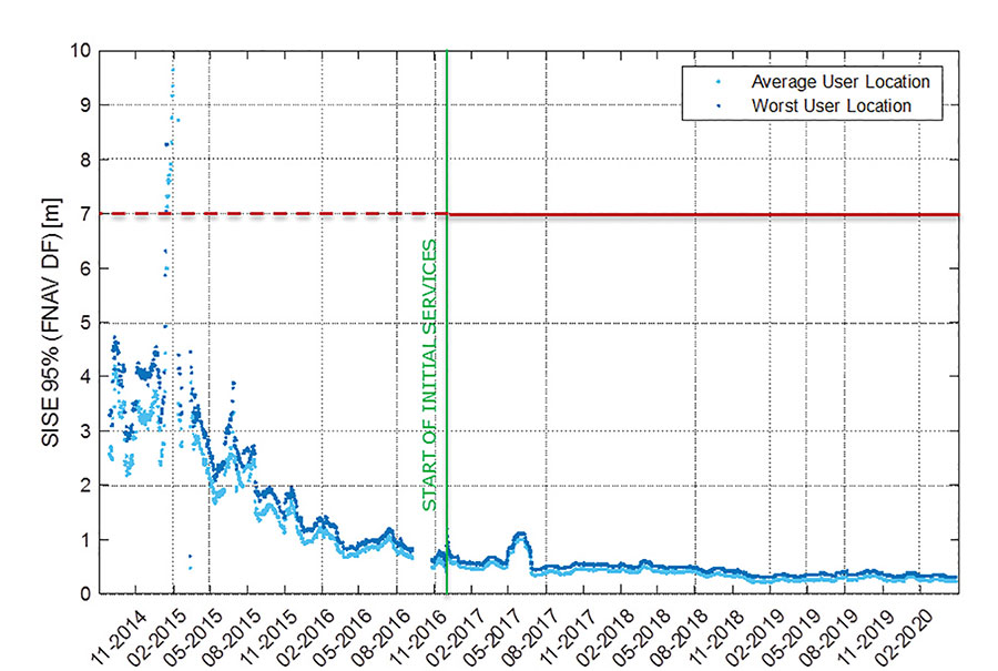
The long-term evolution of performance parameters reveals that the Galileo system is continuously improving. In particular, an excellent quality of the navigation message in terms of ranging accuracy can be observed. Since the Initial Service declaration in 2016, ranging accuracy has steadily improved reaching a level of ~25 cm (95%) by mid of 2020, see Figure 1.
FIGURE 1. F/NAV SISE as observed by user receivers (constellation average, 30 days moving average). (Image: ESA)
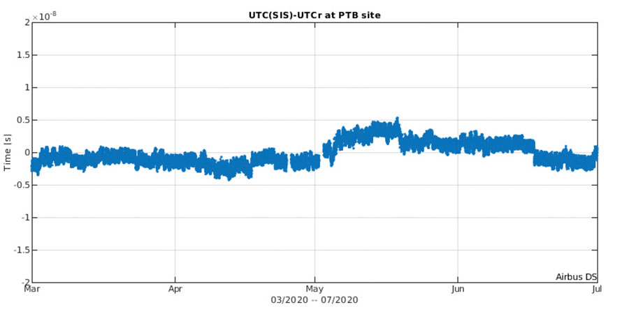
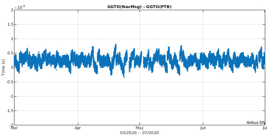
The timing accuracy benefits from the larger number of satellites in service. Figures 2 and 3 present the evolution of the UTC dissemination accuracy and GGTO accuracy performance better than 2.5 nsec and 4.2 nsec (95%) respectively, which are largely within Galileo service commitments.
Probably the most significant discriminator of Galileo versus other GNSS is its capability to broadcast multi-frequency (E1, E6, E5) signal components on all operational satellites. In the high-end and mid-range smartphone chipset market, dual frequency is becoming the norm. All large players have released dual-frequency chipsets, and the first dual-frequency chipsets targeting the budget device market are now becoming available. Dual-frequency receivers offer improved accuracy and robustness, and potential access to high-accuracy techniques. Multi-constellation is now standard for high-volume chipsets and Galileo with its multi-frequency capability is one of the largest GNSS contributors to this emerging dual-frequency PNT market.
Expanding Galileo Services Portfolio
Galileo offers the Galileo Open service (OS) for positioning and timing services, and Europe’s Search and Rescue (SAR) service contribution to COSPAS-SARSAT, equipped with its unique Return Link Message (RLM) declared operational in January 2020. Furthermore, the Galileo system is expanding its infrastructure capabilities such that, once fully operational, it will offer additional high-performance services worldwide.
Public Regulated Service (PRS) is restricted to government-authorized users for sensitive applications that require a high level of service continuity.
Open Service INAV message improvements on Galileo E1-B are under implementation, namely robust symbol level synchronization patterns, additional insertion of clock and ephemeris data with flexible outer encoding and frequent provision of shortened clock and ephemeris for improved robustness in terms of navigation data retrieval in challenging environments, in addition to facilitating a reduced time to first six (TTFF); these improvements ensure backwards compatibility with previously released OS SIS ICDs.
Open Service Navigation Message Authentication (OS-NMA) providing the free authentication of the Galileo Open Service (OS) for geolocation information through the Navigation Message (I/NAV) broadcast on the E1-B signal component.
Commercial Authentication Service (CAS), complementing the OS, providing a ranging authentication function implemented by encrypting the spreading code of the E6C (pilot) channel with a secret key. To ensure backward compatibility, CAS is based on the only civilian signal including cryptographic features (E6). When using both OS-NMA and CAS, users will benefit from data (navigation message) and range authentication, allowing PVT authentication worldwide.
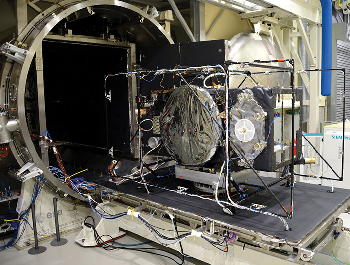
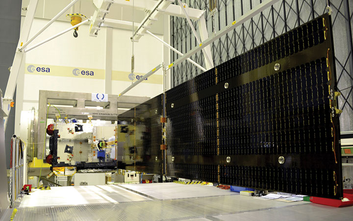
Galileo Batch 3 satellite under test at ESA’s ESTEC facility in the Netherlands. (Photo: ESA)
High Accuracy Service (HAS) complementing the OS by delivering free access high accuracy data and providing better ranging accuracy, enabling users to achieve sub-meter level positioning accuracy.
Support to Safety of Life (SoL) Services through Dual Frequency Multi-Constellation (DFMC) SBAS and supporting the provision of integrity through the concept of Horizontal Advanced Receiver Autonomous Integrity Monitoring (H-ARAIM). In this context, the Galileo Integrity Failure Mode and Effect Analysis (IFMEA) Process is implemented through measurements and review of the system design, including characterization of feared events.
Galileo Batch 3 satellite under test at ESA’s ESTEC facility in the Netherlands. (Photo: ESA)
Infrastructure Modernization
The Galileo System infrastructure is being upgraded and modernized to support the full service portfolio, provide additional robustness and resilience, ensure security and improve operations.
The Galileo Ground Segment is being upgraded implementing ground segment virtualization technologies. This modernized infrastructure will make it possible to easily accommodate technology refresh and will minimize impact to Galileo service operations, under the responsibility of Spaceopal GmbH, during future deployment activities.
Current ground segment upgrades under production by prime contractor Thales Alenia Space in France (in charge of Ground Mission Segment and Security Monitoring) are addressing the deployment of improved robustness of the navigation and precise timing solutions, the full scope of PRS service capabilities, the expansion of the sensor station and up-link ground station networks, and additional security monitoring coverage to protect Galileo ground and space assets.
Ground segment upgrades under production by prime contractor GMV in Spain are addressing the deployment of a new Ground Control Segment providing increased constellation monitoring and control capabilities up to 38 satellites, enhanced operability features, expansion of the TTC network and additional security protection capabilities.
Upgrades of the Galileo Service Facilities are underway as well, notably the evolution of the GNSS Service Center toward the integration of the OS-NMA and HAS capabilities, and the extension of the reference measurement capabilities of the Galileo Reference Centre, by the prime contractor GMV in Spain. The robustness of the SAR service operations, under the prime contractor CNES in France, is also under improvement.
The production of 12 additional Batch 3 Galileo first generation satellites is proceeding, aiming at readiness for launch from mid 2021 onward. Batch 3 satellites are comparable to the 22 FOC satellites launched previously and built by the same prime contractor OHB Systems in Germany. With Batch 3 satellites, Galileo will reach its full constellation capability, including a number of in-orbit spares.
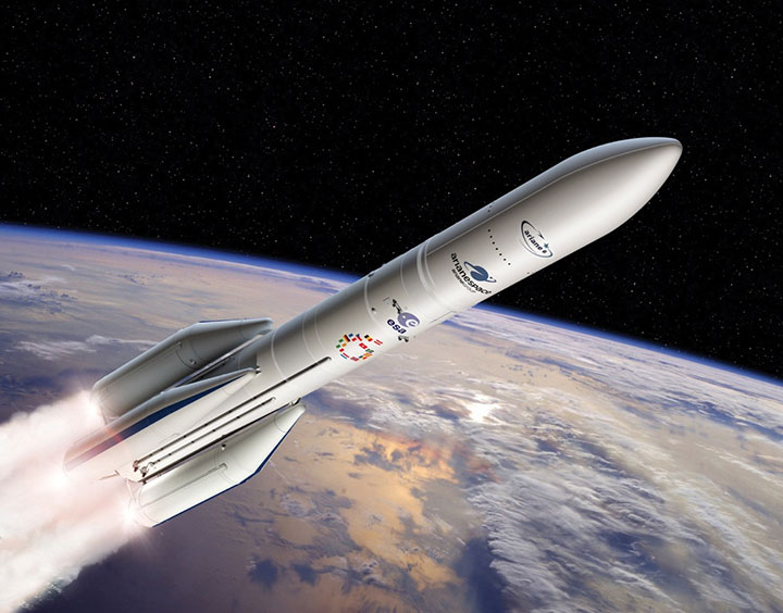
Galileo Batch 3 satellites will be progressively launched with the new Ariane 62 launcher vehicle, the two strap-on solid booster variant of Ariane 6, currently undergoing the final stages of development led by prime contractor ArianeGroup. Meanwhile, France’s space agency CNES is preparing the Ariane 6 launch facilities at Europe’s Spaceport in French Guiana. Ariane 6 is scheduled for its first launch in 2022.
Europe’s new Ariane 6 launch vehicle. (Artist’s concept: ESA)
Toward Galileo Second Generation
The Galileo Programme is fully engaged in the process of developing Galileo 2nd Generation (G2G). Procurement activities for system, satellite and ground segment have been initiated in 2020 with the ambitious goal of starting deployment of the new infrastructure in 2024.
The design of G2G is driven by overarching principles, including backward compatibility, providing an extended portfolio of services and the quality of services, but also the absolute need to meet user demands in a timely and effective manner. The European Commission, in close consultation with EU member states, has converged onto an ambitious set of long term PNT goals for the future European GNSS infrastructures.
G2G Service Portfolio and High-Level Mission Objectives agreed with Programme Stakeholders Service include service evolutions in the areas of signals evolution for increased performance and reduced complexity and power consumption at the user receiver level, time to first-fix, accuracy, authentication and other service attributes, PRS evolutions, advanced timing services, enhanced integration with terrestrial systems (5G/6G), complementarity with external sensors (such as INS, barometer, lidar) and application environments (such as low power devices and internet of things), SAR service evolution, Emergency Warning services, Space Service Volume and Ionosphere Prediction Service.
G2G will build on advanced navigation technology developed over the past 10 years under ESA’s European GNSS Evolution Programme (EGEP) and EU’s Horizon 2020 Programme. This technological leap will allow the early introduction of novel Galileo system features:
Open service capabilities (reduce power consumption and convergence time)
High-accuracy evolution (integrity, availability)
PRS robustness and transmit power
System and SIS in-orbit flexibility, reconfiguration and time-to-market
Inter-satellite links (ranging, mission dissemination, command and control)
SAR second-generation beacons
Reduce operations and maintenance cost
Accelerate time-to-market of new services
Ground technology virtualization and modernization
Acknowledging the changing nature of user requirements, the Galileo second-generation is designed to evolve incrementally and with sufficient flexibility to provide new services or signal features, if and when required, by dynamic reconfiguration of space and ground infrastructure.
The Galileo Second Generation will phase in of new services, improve existing services and increase security
The technology multinational GMV is playing a key role in the Galileo Second Generation (G2G) ground segment.
G2G’s main objectives are to phase in new services, improve existing services, and boost system robustness and security while cutting both operating and maintenance costs, to cement Galileo’s position as one the future’s top GNSS.
Three phases. G2G is divided into several phases. In the first, led by the European Space Agency (ESA), mission requirements were defined at system level. This was followed by a preparation phase, then an implementation phase.
As well as priming several mission-requirement projects, GMV, since 2018, has been heading one of the consortia working on G2G’s complete ground segment during the preparation phase.
Within the preparation phase — shortly before the start of the COVID lockdown — ESA announced the successful end of the first phase before launching a bid invitation for the second phase as the prelude to G2G implementation.
Although publication of the bid invitation for this phase was eventually pushed back until mid-June, GMV never broke off its G2G activities. In recent months GMV has brought new recruitments and partners into the project team while also working on new ideas and kicking off some project activities.
Team members have attended various skills-training courses, some of them gaining certification under SAFe 5 Agilist. During these months, GMV has also been working under new pandemic circumstances with teleworking, virtual meetings and new toolboxes.
First Generation. Galileo First Generation (G1G), running since December 2016, consists of space infrastructure (26 satellites to date) and ground infrastructure. Galileo is now providing 20-cm-precision positioning, navigation and timing services for over 400 million users around the world.
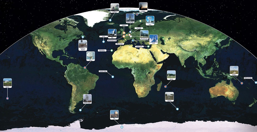
The worldwide Galileo ground segment includes two control centers (Italy and Germany) as well as various tracking, uplink and sensor stations and monitoring and test centers. (Image: ESA)
The European Space Agency (ESA) has awarded a contract to London-based CGI to develop a GNSS Event Notification Service (GENS) capable of monitoring the United Kingdom (U.K.) GNSS spectrum to enable effective alerting and reporting of position, navigation and time (PNT) disruption.
GENS will integrate CGI’s PNT Incident Event Monitoring (PNTIEM) system with existing U.K.-developed sensors from Ordnance Survey’s network (OS NET) of GNSS receivers and GMV NSL’s Detector, GISMO and Strike 3 interface technologies.
Bringing together existing systems will build on proven technologies, reducing the cost of development of a large-scale monitoring network while providing the ability to introduce new services for detecting GNSS events and disruption, according to a CSI press release.
Supported by the OS and GMV NSL, CGI will lead the delivery of GENS using an agile software delivery experience, supported by system design and DevSecOps development and integration skills. An open interface will be offered for future providers of GNSS measurements or spectrum event data.
Alongside the GENS system technical delivery, the National Physical Laboratory (NPL) will develop a GNSS guidance document in partnership with U.K. government departments, agencies, CNI operators, professional institutes, academic institutes and commercial organizations to enable informed requirements development, procurement, deployment and support of HMG GNSS-reliant services.
Reviewed alongside events identified by GENS, the combined offering will highlight and inform stakeholders on risks posed by the loss of PNT services as identified by the PNT Strategy Group Interim Report in April 2020.
GENS will also respond to HMG’s “Satellite-derived time and position: a study of critical dependencies” report which identified the need for mitigation to GNSS disruption and estimated the economic impact to the U.K. economy of a five-day disruption to GNSS at £5.2 billion.
The full GENS system will enable users across both commercial and public sector services to subscribe to be informed of both GNSS quality and interference events for regions of interest. By focusing on these events and the improved understanding of the risk posed by disruption, stakeholders will be better informed to enable them to build system resilience or to respond to the disruption of GNSS within the U.K.
‘‘Detecting and monitoring GNSS is core to better understanding the scale and risk posed by PNT disruption in the U.K. and across all ESA member states,” said Rafael Lucas Rodriguez, technical officer for GENS, European Space Agency. “ESA is supporting CGI to develop effective tools enabling a system to be created utilizing previous ESA and UK HMG work. This will bring direct benefits for U.K. public and private stakeholders.”
“The U.K. is a leading investor in GNSS research,” said Andy Proctor, U.K. lead delegate to the ESA Programme Board for Navigation. “Understanding GNSS spectrum quality is vital for the stability of PNT services in the U.K. This program will help promote and address GNSS disruption affecting PNT services while supporting the U.K.’s thriving space sector and the wider economy.”
“This is an exciting project that brings together CGI’s navigation and spectrum domain expertise supported by scaled agile and DevSecOps delivery experience,” said John Hanley, vice president of secure and assured space solutions at CGI in the U.K. “After talking to both public and private stakeholders for GNSS, it became clear that one of the initial challenges is understanding the scale of PNT disruption. GNSS services touch every part of society across finance, utilities, transport and defense and need to be protected.”
CGI has been delivering complex, mission-critical space software systems for clients across Europe, Asia and North America, supporting satellite navigation, communications, operations and space enabled applications for more than 40 years.
The European Space Agency (ESA) has launched a call for proposals to demonstrate the capabilities of new 5G cellular networks to support positioning and timing applications to complement satellite navigation.
5G will bring higher speed, larger traffic capacity and ultra low-latency (or signal delay) communications. 5G will also usher in a range of new possibilities for positioning, navigation and timing (PNT).
ESA is inviting proposals to implement pilot projects to demonstrate the viability of 5G PNT solutions in a number of use cases:
Indoor PNT for Industry 4.0, as needed to support the operations of smart warehouses and factories or smart city applications requiring transition from indoor to outdoor environments.
Outdoor applications where a robust back-up to satellite navigation is essential to meet safety requirements, such as autonomous driving or drone navigation.
Applications where robust time and frequency synchronization is necessary, both in outdoor as well as indoor environments, like smart energy grids or the 5G networks themselves.
5G networks will allow new types of measurements made possible by advanced antennas and by new positioning signals at higher frequencies, at both base stations and the user receivers. 5G networks will also bring enhanced connectivity to improve cloud-based positioning applications and value-added services.
While satellite navigation works optimally in outdoor environments with a wide view of the sky, 5G PNT has the potential to bring PNT to deep urban canyons in high-rise city centers and indoor warehouses, wherever 5G networks are deployed.
The combination of satellite navigation and 5G brings the promise of high performance, secure and resilient PNT services, as well as a seamless application of PNT applications from outdoor to indoor environments and from rural to urban areas, ESA said.
This call for ideas is supported through ESA’s Navigation Innovation and Support Programme (NAVISP), working with European industry and academia to develop innovative navigation technology.
Webinar on PNT 5G
To support the call, an information webinar is being held on 21 October, in which the various PNT 5G use cases will be presented by key speakers from each sector. Details of the call and how to apply will also be presented by ESA.
A networking platform has also been established to allow webinar participants and general stakeholders interested in the call to get in touch and discuss possible cooperation. This platform will be kept open during the entire period of the call’s duration.
For more information on the call and the agenda of the webinar visit ESA’s NAVISP website.
To register for the webinar and the networking platform, click here.
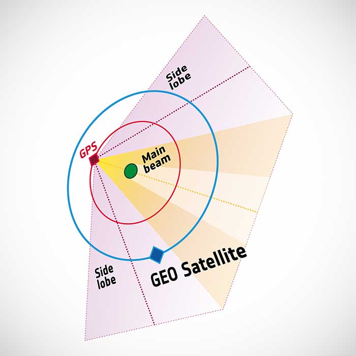
To pinpoint a location accurately, a receiver — in smartphones or on a spacecraft — needs to collect and combine signals from at least four navigation satellites. The receiver determines its distance from each of the satellites by measuring the time that it takes for the signal to travel from the satellite to the receiver.
Navigation satellites aim their antennas directly at Earth. Satellites orbiting above the navigation (GPS in this image, but Europe’s own navigation system is Galileo) constellation could only hope to detect signals from Earth’s far side. Now spacecraft can make use of signals emitted sideways from navigation antennas, within what is known as “side lobes.” Just like a torch, they shine energy to the side as well as directly forward.
Navigation satellites orbit 22,000 kilometers above Earth’s surface. As they point in the direction of Earth, any spacecraft between them and Earth are served well by their signal. But around 10 years ago, engineers started demonstrating that spacecraft outside the orbit of navigation satellites could also navigate in space using “spill over” signal from the satellites.
Then in 2012, two discovery and preparation studies explored a seemingly radical question: could this spillover signal even be used to navigate our way around the moon, and if so, what kind of receiver would we need to build to be able to use these signals?
The studies found that the signal from navigation satellites orbiting Earth could be used to navigate the moon’s surface. But with the signal being so weak, they found that a new type of receiver would need to be built, and at the time there was no clear application for this.
Eight years later, ESA invested in the development of such a receiver, and is exploring whether it could be demonstrated on the Lunar Pathfinder mission. ESA is collaborating with Surrey Satellite Technology Ltd. and Goonhilly Earth Station on this mission, which will provide exciting new opportunities for science and technology demonstration. In particular, it will help lay the groundwork for providing navigation services around the moon, currently studied through two ESA NAVISP activities and culminating in the Moonlight initiative.
“We have now accurate simulation results that show that navigation signals may be used at moon orbit and provide good performances,” said Dr. Javier Ventura-Traveset, head of the Galileo Science Office and in charge of coordinating all GNSS moon activities for ESA’s Navigation Directorate. “And with an innovative receiver in Lunar Pathfinder, we could have the first ever experimental evidence of this.
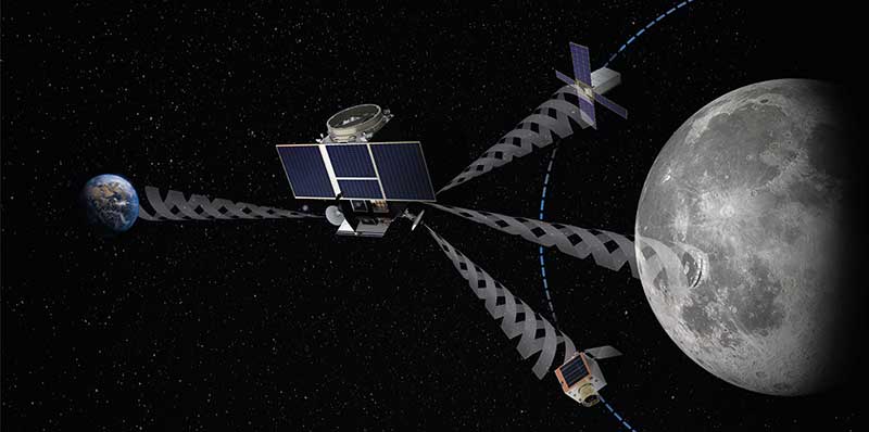
Artist’s impression of the Lunar Pathfinder mission. (Image: SSTL)
“Furthermore, we are also studying how existing navigation constellations may be complemented by additional moon-orbiting satellites, providing additional ranging signals for an optimal navigation service including moon landing and moon surface operations. This is being done as part of the ESA NAVISP program and through the ESA Moonlight initiative.”
“The discovery and preparation studies have been eye-openers and they are currently being followed up by a NAVISP activity aiming to develop the highly sensitive spaceborne navigation receiver planned to fly on board Lunar Pathfinder,” said ESA Radio Navigation Engineer Pietro Giordano. “This technology will enable improved performances and much more cost-effective ways to navigate and operate missions to and around the moon.”
Mobile GIS Services (MGISS) is working with the European Space Agency (ESA) to showcase the potential of satellite positioning systems and imagery in tackling some of the environmental and societal challenges being faced by the water industry.
The two organizations joined together to develop multimedia experiences, group exercises and real-world case studies, which will be shared at the Northumbrian Water Innovation Festival, taking place Sept. 15.
The four-day festival, which has attracted more than 6,500 visitors across previous events, will take place virtually from Sept. 14-17.
“Under the theme ‘We Need Space to Innovate,’ we are aiming to explore how we can use satellite services to improve asset management for organizations such as Northumbrian Water, alongside the wider water and critical infrastructure sectors,” said Mike Darracott, MGISS managing director.
A highlight of the organizations’ participation will their Daily Dashes. The Daily Dashes will be rapid, sprint-style workshops that run through all stages of the subject and include music, video, live demonstration and hands-on workshops to explore specific topics relevant to the water industry. According to MGISS and ESA, the Daily Dashes will provide a better understanding of how satellite services can be used to improve asset insight and operational performance.
“Satellite positioning systems are extensively used for asset location, and yet do users really understand the full array of technology on offer or the additional potential that can be derived from earth observation data?” Asked Alan Cross, regional ambassador for ESA. “By working with MGISS, we will demonstrate how improved positioning and asset insight has the potential to deliver benefits for operational resilience, improved safety and higher productivity.”
GPS World’s November 2020 issue will focus on water applications, so stay tuned for that issue.
With 26 satellites now in orbit and more than 1.5 billion smartphones and devices worldwide receiving highly accurate navigation signals, Europe’s Galileo navigation system will soon become even better, ensuring quality services over the next decades.
Following the European Commission’s decision to accelerate development of Galileo Next Generation, ESA has asked European satellite manufacturers to submit bids for the first batch of the Galileo Second Generation (G2) satellites. The new spacecraft are expected to be launched in about four years.
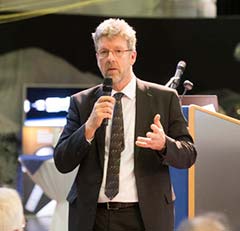
Paul Verhoef, director of the Galileo Programme. (Photo: ESA)
The next-generation satellites will provide all the services and capabilities of the current first generation with a substantial improvements and new services and capabilities.
“We want an ultra-flexible and mostly digital design,” said Paul Verhoef, ESA director of Navigation.
“Developing the second generation is challenging for both industry and for ESA. In 2024, we need to launch the first satellites for this new state-of-the-art constellation.”
Invitation to Tender
Following almost 24 months of a competitive dialogue procedure with the three large system integrators involved, ESA issued a “Best and Final Offer” invitation to tender on Aug. 11 to Airbus, OHB System AG and Thales Alenia Space.
ESA is implementing a dual-sourcing approach, and two parallel contracts are expected to be signed by the end of 2020 among the current three bidders. Under the plan, each of the two selectees will build two satellites for development purposes, with options for up to 12 satellites in total.
The first satellites of the new constellation are expected to be launched before the end of 2024, together with updated ground systems to support the new satellites.
Reconfigurable in Orbit
In addition to being more powerful, the second-generation Galileo satellites will be more flexible, able to be reconfigured in orbit in order to satisfy the expected evolution in end-user needs.
A number of challenges exist for the bidders. The goal of a digital and fully flexible design represents the cutting edge of industrial capability.
Navigation Antenna Progress
A Galileo satellite undergoes its fit-check validation at the Kourou Spaceport in French Guiana. (Photo: ESA/Arianespace)
Furthermore, the required navigation antennas will have a very advanced design; much research and development by ESA has been done, yet more remains for industry.
ESA has already built such an antenna as a proof of concept at the Agency’s ESTEC technology center in the Netherlands to ensure feasibility, and the know-how has been shared with the three bidders.
“Each bidder must determine how they can best manufacture the navigation antenna, and we’ll have to see how each proposes to do it. Also, requiring a fully flexible payload is quite a challenge. No such navigation spacecraft of that type have flown yet,” Verhoef said.
Ambitious Plan
The European Commission has decided that what was previously going to be called the “transition batch” of new satellites will now become, in fact, the Galileo Second Generation satellites. The European Commission and EU Member States have already made clear that they want to be very ambitious and further increase the technical capabilities of the Galileo system.
The name change reflects of how the current batch is actually shaping up.
The transition satellites were initially foreseen as interim upgrades, to cater for the potential risk of late delivery of the later, completely new and very advanced G2 satellites.
Estimated Lifetime Increased
Based on constant measurements of the performance of the current satellites in orbit, their predicted lifetime has increased. So, together with a slight spreading out of the launches of the Batch 3 satellites — currently under construction by OHB and in testing at ESTEC —this will ensure service continuity before the new, advanced capabilities of Galileo become operational.
The second-generation satellites will gradually take over from the current first-generation satellites in the provision of Galileo services. At a future date, they will all constitute a complete constellation plus the necessary in-orbit spares.
ESA serves as the design, development and procurement agent for Galileo satellites on behalf of the European Commission, which funds the system overall.