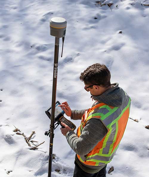
Verified photomontages for UNESCO World Heritage sites achieves accuracy with Spectra Geospatial SP80
Verified photomontage is an important planning tool to envision how proposed surrounding development plans would affect UNESCO World Heritage sites. Verified photomontage demands the best accuracy for the best visualization to determine what a development may look like to a person standing at the photographic viewpoint.
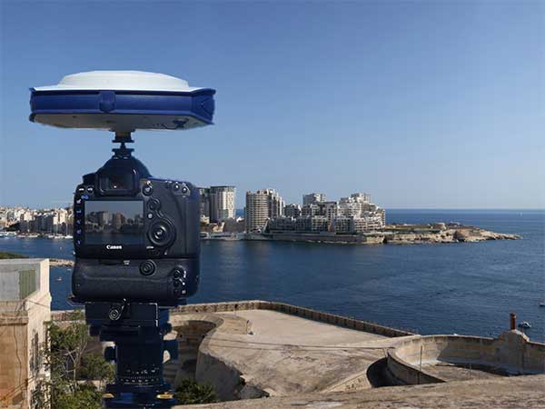
For MS Environmental (MSE), selected to provide verified photomontage for multiple UNESCO World Heritage sites, including in the UK Royal Botanical Gardens at Kew and the City of Bath, the Spectra Geospatial SP80 GNSS receiver enabled the highest quality visualization.
“The one-centimeter accuracy delivered by the SP80 is essential,” said Mike Spence, a verified photomontage specialist and founder of MSE. “The highest level of accuracy in the relationship between the actual camera location and the 3D model camera gives confidence in the visualization. In addition, The SP80 offers both simplicity and a robust design though it’s taken a few knocks over the years, it gives us the confidence we can use the equipment anywhere in the world and get the best results.”
At Kew Gardens, MSE was commissioned to produce accurate visualizations of views from within the UNESCO World Heritage Site. There was concern about development proposals for tall tower blocks in west London and how these might affect historic views from Kew Gardens.
The work culminated in a public inquiry, where evidence was presented that showed how views would change as a result of the proposed development. “Without the level of accuracy provided by the SP80 together with a transparent technical methodology it would have been unclear precisely how these historic views would change,” Mike Spence said.
At the UNESCO World Heritage City of Bath, the Bath and North East Somerset Council commissioned MSE to produce technical photography from strategic views around the World Heritage City to show how development proposals would affect strategic views across the city.
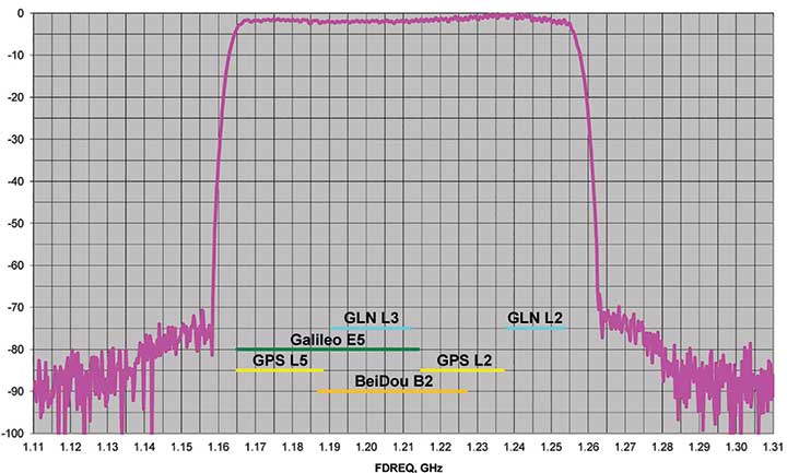
J-Shield is a robust filter on Javad GNSS antennas that blocks out-of-band interference (Figure 1). In particular, J-Shield blocks signals that are near the GNSS bands, including the proposed Ligado Networks (formerly LightSquared) broadband signals, explained Javad Ashjaee, founder and CEO of Javad GNSS.
FIGURE 1. Protection characteristics: The J-Shield filters have a sharp 10-dB/KHz skirt, which provides up to 100-dB of protection. (Image: JAVAD GNSS)
The anti-jam digital filters protect against in-band interference such as the harmonics of nearby TV and radio stations, or against illegitimate in-band transmissions. The anti-jam filters can be combined in pairs for complex signal processing and can simultaneously suppress several interference signals.
“The filters make the near band spectrums available for other uses,” Ashjaee said. “They protect GNSS bands now and in the future.”
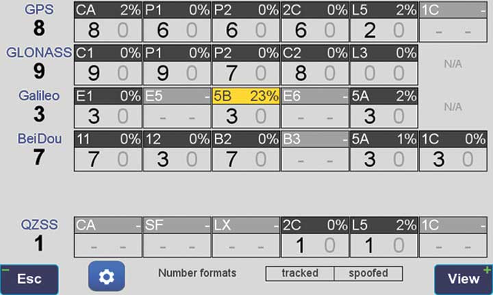
In-Band Noise Measurement. The receiver measures the level of interference as a percentage of noise above the normal condition. Figure 2 shows the condition in a clean environment, where eight GPS satellites were visible, according to the almanac. In all, eight C/A, six P1, six P2, six L2C and two L5 GPS signals were tracked. The noise level was 2% on C/A and L5 and 0% on P1, P2, and L2C.
FIGURE 2. Clean environment. (Image: JAVAD GNSS)
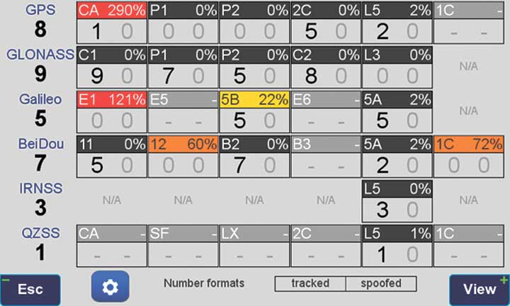
Figure 3 shows 290% noise in the GPS C/A signal and 121% noise in Galileo E1. Only one of the eight GPS C/A code and none of five Galileo E1 signals could be tracked because of the high level of interference.
FIGURE 3. High interference levels. (Image: JAVAD GNSS)
Spectrum Analyzer
Filters in the GNSS antenna provide one way to protect GNSS signals from interference. Another is the receiver chip itself. For instance, the Javad GNSS Triumph chip includes an integrated spectrum analyzer — a more efficient solution than using a commercial spectrum analyzer to continuously monitor and evaluate the environment, Ashjaee explained.
The spectrum analyzer monitors the spectrum inside the chip. It has an effective bandwidth of 1 KHz, and can be programmed to automatically record the spectrum (and other information) periodically or according to pre-set conditions. Each spectrum shows the power and shape of any interfering signals and jammers.
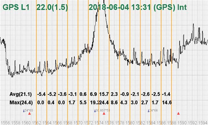
Figure 4 shows the shape of the GPS L1 band spectrum when the band is jammed, as indicated by the huge peak in the center where the C/A code is. The number on the bottom left is the height of the peak. The height of the spectrum is 21.1 dB; compared to a calm spectrum of 11.2 dB, this spectrum indicates a jamming impact of about 10 dB.
FIGURE 4. The L1 band is jammed, as shown by the peak. (Image: JAVAD GNSS)
Automatic Gain Control. In addition to monitoring the spectrum, the Triumph chip also keeps a record of automatic gain control (AGC) — another indicator of unwanted external signals. The AGC monitors the environment and adjusts the gain to keep the voltage at a certain level. The change in AGC is an indicator of interference.
Spoofers
“Spoofers are quite different from jammers,” Ashjaee said. “They don’t disturb the environment and the spectrum shape. They broadcast a GNSS-like signal to fool the GNSS receivers to calculate wrong positions. We detect spoofers by digital signal processing.”
With 864 channels and about 130,000 fast-acquisition channels in the Triumph 2 chip, it has the resources to assign more than one channel to each satellite to find all of the signals transmitted with the same GNSS PRN code — including spoofed signals.
“If we detect more than one reasonable and consistent correlation peak for any PRN code, we know that we are being spoofed and can identify the spoofer signals,” Ashjaee said. The chip isolates and ignores the wrong peak.
“Usually more than 100 signals are available at any given time. We need only four good signals to compute position,” Ashjaee said. “We reject infected signals, and then among all the available GPS, GLONASS, Galileo, BeiDou, IRNSS and QZSS signals, we use the healthy ones. It is extremely unlikely that we can be spoofed without our knowledge. We can immediately recognize spoofing and take corrective actions. In the rare case that all signals are affected, we inform the user and guide them to use a compass and altimeter to get out of the jammed area.”
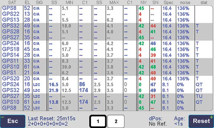
Figure 5 is a screenshot from the company’s Triumph-LS survey receiver, showing the details of each signal tracked. The first six lines in this screenshot show the spoofed signals that were detected as soon as they appeared (number “1” in the C1 column). Percentages show the amount of interference above the normal level.
In the last column, T indicates the signal was tracked by the main channels, Q by the fast-acquisition channels, and U indicates the signal was used in position calculations.
Figure 5. Signal Details: The Triumph-LS receiver provides users with a wealth of information on each signal received, including spoofed signals.
Indicators for Healthy Signals
In addition to the spectrum shape and AGC, these other indicators show the health of GNSS signals:
Number of signals tracked.
Divergence of SNR from its expected value.
Level of additional power and its RMS.
Divergence of AGC from its normal value and its RMS.
Extra noise.
Number of signals spoofed.
As an aid to users, the company’s Triumph-LS receiver can display the status of all GNSS signals received. Figure 6 shows this compact view, with normalized values of the above indicators (0 means good and 9 means poor).
Figure 6. Signal Status. Information on all GNSS signals received as shown by the Triumph-LS. (Image: JAVAD GNSS)
Users of the Triumph-LS can click on any of the signal buttons to see the actual and normalized values of the indicators for that signal. Action buttons provide quick access to View Satellites, View Spoofing, View Spectrum and Take Spectrum. Jamming and spoofing protection is an option on all Javad GNSS products and OEM boards.
Verified photomontages for UNESCO World Heritage sites achieves accuracy with Spectra Geospatial SP80
Verified photomontage is an important planning tool to envision how proposed surrounding development plans would affect UNESCO World Heritage sites. Verified photomontage demands the best accuracy for the best visualization to determine what a development may look like to a person standing at the photographic viewpoint.
For MS Environmental (MSE), selected to provide verified photomontage for multiple UNESCO World Heritage sites, including in the UK Royal Botanical Gardens at Kew and the City of Bath, the Spectra Geospatial SP80 GNSS receiver enabled the highest quality visualization.
“The one-centimeter accuracy delivered by the SP80 is essential,” said Mike Spence, a verified photomontage specialist and founder of MSE. “The highest level of accuracy in the relationship between the actual camera location and the 3D model camera gives confidence in the visualization. In addition, The SP80 offers both simplicity and a robust design though it’s taken a few knocks over the years, it gives us the confidence we can use the equipment anywhere in the world and get the best results.”
At Kew Gardens, MSE was commissioned to produce accurate visualizations of views from within the UNESCO World Heritage Site. There was concern about development proposals for tall tower blocks in west London and how these might affect historic views from Kew Gardens.
The work culminated in a public inquiry, where evidence was presented that showed how views would change as a result of the proposed development. “Without the level of accuracy provided by the SP80 together with a transparent technical methodology it would have been unclear precisely how these historic views would change,” Mike Spence said.
At the UNESCO World Heritage City of Bath, the Bath and North East Somerset Council commissioned MSE to produce technical photography from strategic views around the World Heritage City to show how development proposals would affect strategic views across the city.
Adva has launched a modular multi-band GNSS receiver for ePRTC and PRTC-B synchronization, bringing increased precision timing to 5G networks.
The new solution is engineered to overcome ionospheric delay variation that causes timing inaccuracy, enabling communication service providers (CSPs) and enterprises to deliver nanosecond precision.
Previously, this was achieved with expensive, rubidium clocks.
Installed synchronization infrastructure can be installed to increase accuracy and reliability. The multi-band, multi-constellation GNSS receiver card plugs into Adva’s OSA 5430 and OSA 5440, advanced core grandmaster clocks able to support PTP, NTP and SyncE over multiple 1Gbit/s and 10Gbit/s Ethernet interfaces.
This enables network operators to meet the requirements of the ITU’s stringent PRTC-B specifications and support advanced 5G applications.
“What we’re offering the market is an entirely new route to high-precision UTC-traceable network timing that doesn’t require significant investment. Our future-proof technology gives businesses and CSPs a way to boost synchronization performance and meet the ITU’s tight PRTC-B specifications without resorting to expensive alternatives.”
Photo: Adva
“Our new multi-band GNSS receiver is a major milestone for network synchronization. For the first time, operators can harness a solution with multi-band GNSS capabilities combined with our core devices, which can deliver line rates up to 10Gbit/s and support ePRTC levels of timing accuracy,” said Gil Biran, general manager, Oscilloquartz.
“Our modular technology offers a way to enhance equipment in the field, achieve PRTC-B levels of timing and improve the timing accuracy of ePRTC. All that’s required is a simple antenna upgrade. Then our multi-band solution can be plugged into the available slot of our OSA 5430 or OSA 5440 for the nanosecond accuracy that will be key to the services of tomorrow. And, as enhanced availability is also essential for emerging applications, the new technology features unrivalled jamming and spoofing detection capabilities combined with our centralized AI-powered GNSS assurance suite.”
Today’s launch answers the urgent demand for improved precision in GNSS-based timing. Currently, most synchronization networks rely on single-band receivers, which can only be accurate to a limited degree as delay between satellites and receivers is affected by space weather. This creates delay variations leading to time information being out of step by up to several tens of nanoseconds.
Adva’s Oscilloquartz multi-band technology receives GNSS signals in several frequency bands, enabling it to use the delay differences between them to calculate delay variation and compensate for it. This method is more cost-effective than other techniques, such as deploying GNSS receivers with a filter implemented by a costly high-stability rubidium oscillator. The OSA 5440 can utilize two multi-band cards, providing ultimate hardware redundancy.
“What we’re offering the market is an entirely new route to high-precision UTC-traceable network timing that doesn’t require significant investment. Our future-proof technology gives businesses and CSPs a way to boost synchronization performance and meet the ITU’s tight PRTC-B specifications without resorting to expensive alternatives,” commented Nir Laufer, senior director, product line management, Oscilloquartz. “Combined with our OSA 5430 and OSA 5440 core grandmasters, the technology creates a scalable, fully hardware-redundant solution. Its built-in security also guarantees the most sophisticated detection of malicious attacks. By supporting GPS, GLONASS, BeiDou and Galileo, our multi-band, multi-constellation line card offers a versatile and resilient solution for migrating from legacy to next-generation timing. Simply put, there’s no other technology available today that can match the accuracy, redundancy, capacity and price point of our core devices combined with our new multi-band GNSS cards.”
The new multi-band GNSS receiver will be officially launched this week at ITSF and can be viewed on Oscilloquartz’s stand Nov. 4-7.
Trimble has introduced the the R12 GNSS receiver, a high-performance GNSS surveying solution. Powered by a new real-time kinematic (RTK) and Trimble RTX positioning engine, it features Trimble ProPoint GNSS technology that empowers land surveyors to quickly measure more points in more places than previously.
Surveyors who work in challenging GNSS environments can use the Trimble R12 receiver to help reduce both the time in the field and the need for conventional techniques such as using a total station.
The new Trimble ProPoint GNSS technology allows for flexible signal management, which helps mitigate the effects of signal degradation and provides a GNSS constellation-agnostic operation.
In head-to-head testing with the Trimble R10-2 in challenging GNSS environments such as near and among trees and built environments, the Trimble R12 receiver performed more than 30 percent better across a variety of factors, including time to achieve survey precision levels, position accuracy and measurement reliability.
“As a leader in the field of GNSS technology and innovation, Trimble dedicated many years of intensive research into developing the Trimble R12,” said Ronald Bisio, senior vice president of Trimble Geospatial. “This has culminated in a first-class solution, which enables our users to extend the reach of their systems to places where other RTK GNSS systems experience degraded performance.”
The UAS1 GNSS receiver module has been designed for UAV/UAS applications requiring centimeter accuracy in a small package. (Photo: Trimble)
Trimble has introduced a compact, high-precision GNSS board specifically designed for unmanned aerial systems (UAS).
The Trimble UAS1 has a simple connectivity and configuration to allow UAS system integrators to easily add satellite-based positioning — with the ability to upgrade its capabilities — using rugged connectors and Trimble’s easy-to-use software interface.
The new UAS1 incorporates the latest Trimble Maxwell technology with advances in high-precision GNSS positioning. Its GNSS engine with 336 channels is capable of tracking L1/L2 frequencies from the GPS, GLONASS, Galileo and BeiDou constellations for robust centimeter-level, real-time kinematic (RTK) positioning.
The compact board includes a broad range of receiver capabilities — from high-accuracy GPS-only to full GNSS features for positioning. Firmware options and features are password upgradeable, allowing functionality to be added as requirements change.
The receiver also supports fault detection and exclusion (FDE) and receiver autonomous integrity monitoring (RAIM). System integrators also have the ability to detect interference with the RF Spectrum Monitoring and Analysis tool embedded in the receiver.
“UAS manufacturers demand high performance, reliability and high-quality customized support for their positioning solutions,” said Thomas Utzmeier, general manager of Trimble’s Integrated Technologies Division. “The new UAS1 board delivers the latest GNSS technology in an easy-to-integrate form factor for UAV/UAS applications.”
Designed for easy integration and rugged dependability, the Trimble UAS1 has a Remote Network Driver Interface Specification (RNDIS) that enables manufacturers to access the web UI with the USB connector. As with similar Trimble embedded boards and modules, easy-to-use software commands can simplify integration and reduce development times.
Features also include integrated Trimble RTX technology, an industry-standard camera hot-shoe interface to geo-position photographs, and LED indicators for status checks. The Trimble UAS1 can also output to RINEX, a common postprocessing format.
The Trimble UAS1 supports Trimble CenterPoint RTX GNSS corrections, which enable precise and robust positioning without the use of a base station via a subscription service. CenterPoint RTX allows users to achieve better than 2-centimeter horizontal and 5-centimeter vertical accuracy.
Trimble’s UAS1 is suitable for UAS applications requiring centimeter accuracy in a small package. Manufactured and tested to Trimble’s highest quality standards, the compact design allows for easy setup, configuration and installation in a customers’
system.
Using a full metal shield (the form factor is 71 x 46 x 13 millimeters), the board’s design enables high-precision GNSS signal protection from electromagnetic interference (EMI) on the host UAS platform. In addition, the receiver is FCC- and CE-certified, which speeds compliance for the customer’s overall system and can reduce time to market.
Septentrio and CORE partner up to develop a GPS/GNSS receiver which will make use of Japan’s Centimeter-Level Augmentation Service (CLAS). CLAS corrections are broadcast directly via QZSS constellation to enable high-accuracy positioning across Japan.
Septentrio, a designer and manufacturer of high-precision GNSS technology, and CORE, a Japanese system integrator with extensive experience in GNSS, are jointly developing a receiver that can use the Centimeter-Level Augmentation Service (CLAS) of Japan’s Quasi-Zenith Satellite System (QZSS).
Septentrio’s multi-frequency GPS/GNSS receiver AsteRx4 will be used as a platform for the development of CLAS functionality. Septentrio receivers already track the L6 signal and can use QZSS for increased positioning availability and reliability.
CORE’s know-how will be instrumental for the deployment of CLAS on Septentrio receivers. The two companies are planning to launch their CLAS-enabled receiver in January 2020.
Japan’s CLAS is a self-augmentation GNSS correction service. Without the need for a ground link, it allows real-time kinematic (RTK) centimeter-level positioning all over Japan with convergence times of less than a minute.
It does this by broadcasting GNSS corrections directly via QZSS satellites, also known as Michibiki. These corrections are generated from the dense network of reference stations operated by Japan’s Geospatial Authority.
The two companies have also entered into a distribution contract that allows CORE to sell Septentrio high-precision positioning technology, including CLAS-capable GNSS receivers, in the Japanese market.
The new CLAS-enabled receiver will also incorporate Septentrio’s Advanced Interference Mitigation (AIM+) technology. In busy urban environments electromagnetic waves can interfere with GPS and GNSS signals.
AIM+ offers protection against such interference resulting in faster set-up times and robust continuous operation.
“QZSS Centimeter Level Augmentation Service has been limited to evaluation phase up till now. Realizing CLAS on Septentrio’s multifunctional, high-quality, cost-competitive platform allows our customers to finally use QZSS in their applications,” emphasized Takahiro Yamamoto, Director of GNSS Solution Development Center at CORE Corporation. “Galileo High Accuracy Service (HAS) is expected to start in 2020, so the demand for high accuracy GNSS receivers is also expected to increase. By complementing CORE’s QZSS technology and Septentrio’s Galileo technology, we can provide competitive products to global customers.”
“CLAS is a first-of-its-kind service which will contribute to the proliferation of high accuracy GNSS applications in Japan. Europe is also taking similar initiatives with their Galileo High Accuracy Service (HAS),” commented Neil Vancans, Director of Global Sales at Septentrio. “We are excited to enter into an agreement with CORE to enable the support of CLAS on our receivers. CORE’s expertise allows us to get the best out of CLAS and to follow new developments in QZSS evolution. Moreover, CORE’s expertise in system integration will allow us to tackle new markets in Japan.”
Septentrio’s Gustavo Lopez gives GPS World an overview of the company’s AsteRx-i S UAS GNSS/INS receiver for drones and Mosaic GNSS receiver module at Intergeo 2019, which took place Sept. 17-19 in Stuttgart, Germany.
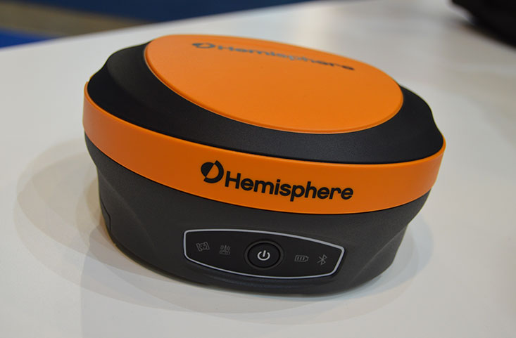
Hemisphere GNSS has introduced its multi-frequency, multi-GNSS S621 GNSS survey smart antenna and R620 GNSS receiver at Intergeo 2019 in Stuttgart, Germany, and ION GNSS+ 2019 in Miami.
S621 GNSS survey smart antenna
The S621 GNSS survey smart antenna is a complete redesign of Hemisphere’s previous generation version, the S321+. (Photo: Allison Barwacz)
The S621, powered by the company’s Phantom 40 GNSS OEM board, is a complete redesign of Hemisphere’s previous generation version, the S321+.
According to the company, the S621 processes and supports more than 800 channels with flexible and scalable simultaneous tracking of every modern and planned GNSS constellation and signal including GPS, GLONASS, BeiDou (including Phase 3), Galileo, QZSS, IRNSS, SBAS and Atlas L-band.
The S621 combines Hemisphere’s Athena GNSS engine and Atlas L-band correction technologies with a new WebUI. It meets IP67 requirements and is immune to magnetic interference. It is designed for use in land or marine survey, GIS, mapping, construction or other applications requiring high-performance precision and positioning, the company added.
“The S621 represents the advanced technology, durability, and ease-of-use that our customers have come to expect,” said Miles Ware, director of marketing at Hemisphere. “By redesigning this system from the ground up with increased functionality and management capabilities, we are offering unbeatable value.”
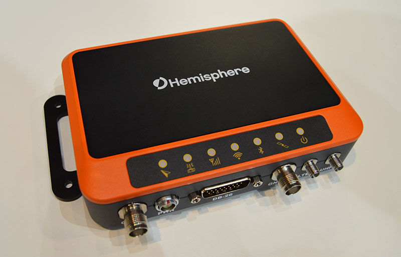
R620 GNSS receiver
The R620 GNSS receiver is a complete refresh of Hemisphere’s previous version, the R330. (Photo: Allison Barwacz)
The R620 GNSS receiver, powered by the Vega series, is a complete refresh of Hemisphere’s previous version, the R330, and includes an all-new low-profile ruggedized enclosure.
According to Hemisphere GNSS, the R620 GNSS receiver processes and supports more than 1,100 channels and offers flexible and scalable simultaneous tracking of every modern and planned GNSS constellation and signal including GPS, GLONASS, BeiDou (including Phase 3), Galileo, QZSS, IRNSS, SBAS and Atlas L-band.
The R620 combines Hemisphere’s Athena GNSS engine and Atlas L-band correction technologies with status LEDs and a WebUI. It also comes equipped with UHF (400 MHz and 900 MHz) radio, cellular modem, Bluetooth and Wi-Fi.
“With its all-new design and feature set, the R620 GNSS receiver is Hemisphere’s offering to what the market desires — smaller machine, lower cost and less power,” Ware said. “The receiver boasts a feature- and performance-packed combination of greater performance, improved robustness and excellent value.”
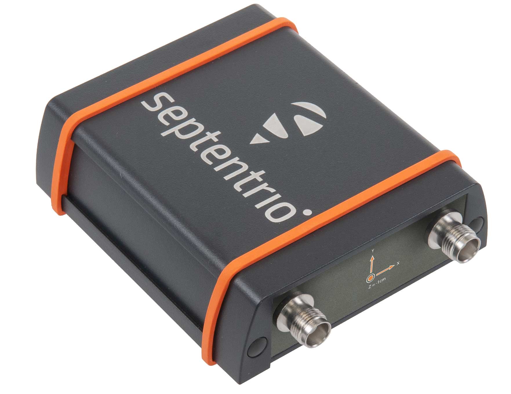
The AsteRX-SBi has a rugged housing, making it suitable for machine control and other outdoor uses. (Photo: Septentrio)
Septentrio has expanded its GNSS/INS portfolio with the AsteRx SBi, a new housed GNSS/INS receiver. The ruggedized AsteRx SBi fuses high-accuracy GPS/GNSS with a high-performance inertial sensor to provide reliable positioning and 3D orientation for machine control and logistic applications.
Within its rugged, waterproof enclosure, a high-performance GPS/GNSS is coupled with an industrial-grade inertial sensor to provide high-accuracy, reliable positioning and 3D orientation (heading, pitch, roll).
Offering the flexibility of either single or dual antenna, AsteRx SBi is designed for quick and easy integration into any machine monitoring or control system. AsteRx SBi packs performance and durability into a single, compact box. Reliable location and 3D orientation data is streamed with a high update rate and constant low latency.
“AsteRx SBi was designed with ease of integration and reliability in mind. Its compact, ruggedized housing is optimized for easy clamping to any machinery,” said Danilo Sabbatini, product manager at Septentrio. “It has all the features and tools needed for straightforward integration into machines or large robotic systems.”
Septentrio reliable centimeter-level positioning is based on true multi-frequency, multi-constellation GNSS (GPS, GLONASS, Galileo, BeiDou, QZSS) technology. AsteRx SBi combines GPS/GNSS and an industry-grade IMU (inertial measurement unit) to deliver precise positioning together with 3D attitude.
The AsteRx SBi is a robust positioning solution for machinery operating in environments challenging for GNSS. (Photo: Septentrio)
Septentrio’s unique GNSS–IMU integration algorithm enables continuous positioning in environments of low satellite visibility where short GNSS outages are possible. This is referred to as coasting or dead reckoning, and can happen near high structures, under bridges or under thick foliage. This makes AsteRx SBi a robust positioning solution for machinery operating in environments challenging for GNSS, such as in container yards, urban canyons or near cliffs.
AsteRx SBi comes with built-in Advanced Interference Mitigation (AIM+) technology. In busy urban environments electromagnetic waves can interfere with GPS and GNSS signals. AIM+ offers protection against such interference resulting in faster set-up times and robust continuous operation. A built-in power spectrum plot allows users to analyze interference, helping locate its source and mitigating it.
Tersus GNSS President and CEO Xiaohua Wen gives GPS World an overview of the company’s Oscar GNSS receiver at Intergeo 2019 in Stuttgart, Germany. According to the company, the Oscar GNSS receiver offers calibration-free tilt compensation that is immune to magnetic disturbances.