FJDynamics has released the Trion P1, a compact handheld lidar scanner and the Trion V10i GNSS system, both with visual positioning. These systems were unveiled at INTERGEO 2023.
Trion P1 lidar scanner
FJD Trion P1 lidar scanner. (Image: FJDynamics)
The simultaneous localization and mapping (SLAM)-based lidar scanner allows users to accurately digitize environments. With the ability to capture indoor, outdoor and underground environments, this compact scanner can be used across a variety of industries such as property management, disaster preparation, forestry and more.
“Our goal at FJDynamics is to bridge the gap between advanced technology and practical applications,” said Mike Zhao, senior product manager. “With the Trion P1 lidar scanner, we’re putting the power of reality capture into the hands of both seasoned professionals and those curious about 3D scanning.”
Key features of the scanner include a lidar capacity of 200,000 points per second, and real-time point cloud visualization on mobile devices via Trion Scan. In addition, it can calculate distance, area and volume.
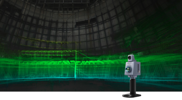
Trion V10i GNSS system with visual positioning
FJD Trion V10i GNSS system with visual positioning. (Image: FJDynamics)
The FJD Trion V10i GNSS System integrates two cameras for vision-guided surveying operations, an inertial measurement unit (IMU) for tilt surveys and an OLED screen for easy status checks. This technology is designed to enhance productivity in the field, even in hard-to-access locations.
The technology features IMU-based tilt compensation for precise measurements of up to 60 ° with no calibration needed. It also comes with a built-in 4G LTE and UHF and supports NFC, WiFi and Bluetooth. It also offers users seamless connectivity through Trion Survey Cloud for real-time data sharing between field and office teams.
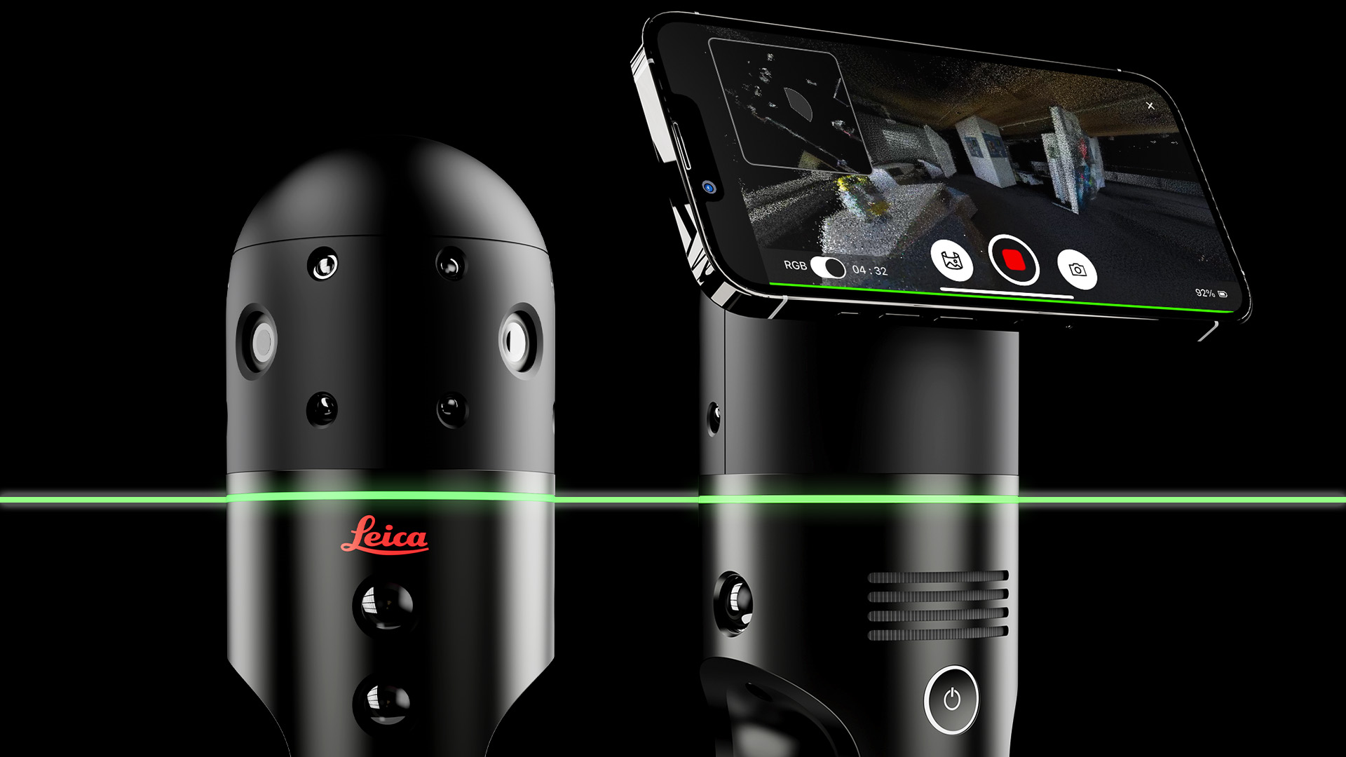
Leica Geosystems, part of Hexagon has developed the Leica BLK2GO PULSE, its first-person laser scanner that combines lidar sensor technology with the original Leica BLK2GO form factor. The technology is set to be released in early 2024.
The scanner offers users a rapid, simple and intuitive first-person scanning method that can be controlled with a smartphone, and delivers full-color 3D point clouds instantly in the field.
The BLK2GO PULSE was built in collaboration with Sony Semiconductor Solutions Corporation to combine Sony’s advanced time-of-flight (ToF) image sensors with Leica Geosystems’ GrandSLAM technology, resulting in a dual ToF hand–held scanner.
The product is designed for indoor applications such as the creation of 3D digital twins and 2D floor plans. It includes first-person scanning capabilities and instant data availability, allowing users to immediately download, view and share colorized 3D point clouds and images from the field. Scans can then be uploaded to Reality Cloud Studio, Hexagon’s cloud application for reality capture data visualization, collaboration and storage.
ANELLO Photonics has added real-time centimeter-accurate positioning and localization capabilities to its line of optical-gyroscope based navigation systems.
Its real-time centimeter accuracy is achieved by using real-time kinematic (RTK) correction data from GEODNET, a community-based decentralized network of over 3,000 GNSS reference stations worldwide.
Under the agreement, ANELLO Photonics users will have access to a free trial of RTK services and competitive options for long-term, high-volume correction data requirements.
By combining the ANELLO silicon photonics optical gyroscope (SiPhOG) with GEODNET’S global RTK correction network, users now have access to a new global cyber-infrastructure for reliable measurements.
The partnership offers users a combination of optical gyroscope technology and a reliable and global RTK correction network that enables centimeter-accuracy for industries operating in challenging RF and GNSS-denied environments. These environments include city centers, construction sites and orchards.
The agreement aims to address the challenging applications by using SiPhOG and its GNSS-denied dead-reckoning algorithms with GEODNET’s distributed global network of RTK stations. This combined technology offers high-level accuracy while reducing the total solution costs.
The companies aim to simplify performance intensive applications such as high-definition mapping and aerial or terrestrial autonomous vehicle deployment.
ANELLO is currently engaged in trials with users in the construction, farming, robotics, trucking, UAVs, autonomous vehicles, and defense space.
On the first day of INTERGEO 2023, attendees flooded the exhibit hall. (All photos taken by GPS World staff).
The 29th INTERGEO conference and trade show on geospatial technology and data was held from October 10 to 12 in the German capital Berlin. This year’s event took place under the famous radio tower and in the brand new Hub27 conference center, part of the 42-acre Messe Berlin exhibit and conference center. The annual event takes place each year in a different German city.
Over the three days, 560 vendors from more than 40 nations exhibited their products, while people from across the globe attended presentations and vendor exhibits on geodesy, geoinformation and land management. Topics covered included Earth observation and environmental monitoring, maritime solutions, unmanned systems, building information modeling (BIM), GIS and artificial intelligence, metaverse and cloud applications, smart cities, digital twins, COPERNICUS and Galileo satellite services, 4D geodata, 3D cadaster, and smart mapping applications. The focus was on how these technologies and data are used to address issues of housing, mobility, sustainability, climate change and internal security, monitoring for disaster prevention and protection, and the creation of more equitable living conditions.
In conjunction with the conference, the German Cartography Congress 2023 also convened, with lectures on such topics as atlases, map collections, map design, and artificial intelligence. In her keynote address, Professor Monika Sester discussed how machine learning methods help with generalization and Professor Sebastian Meier gave a provocative lecture titled “Critical Cartography in Times of Hallucinating Machines.”
Attendees at a presentation from the exhibit hall stage.
Day 1, Tuesday, October 10
On the first day of INTERGEO 2023, keynote speakers included Jack Dangermond, founder and CEO of ESRI, professor Paul Becker, president of the Federal Agency for Cartography and Geodesy, Scott Crozier from Trimble and professor Rudolf Staiger, president of the organiser DVW e.V. The main theme was the centrality of geospatial science and technology to sustainability because the basis of socially, ecologically and economically sustainable decisions lies in the understanding of the Earth system. This is increasingly achieve using geoinformation gathered through Earth observation and many other sensors.
GPS World conducted short interviews with Gustavo Lopez, market access manager atSeptentrio and Deyn Deng, overseas sales manager at Unicore.
Some surveying supplies that have been used for centuries are still in use today.
Day 2, Wednesday, October 11
On the second day of INTERGEO 2023, the focus of the keynote presentations, like that of many of the products in the exhibit hall, was “smart cities” and building information modeling (BIM), including a panel discussion on the importance of BIM in Germany. Related themes discussed in the presentations, on the exhibit hall stages, and at vendors’ booths included connected urban twins, sensor data, real-time applications, urban twins as drivers of innovation for local governments, maritime solutions, Earth observation, and unmanned systems.
An autonomous bathymetric vessel from Teledyne Marine.
At a press conference on navigating sustainability through geospatial insights the participants were Rudolf Staiger, president of DVW, Boris Skopljak, Vice President survey & mapping strategy and product marketing at Trimble, Thomas Harring, president Geosystems at Hexagon, Gerd Buziek, Business Relations Executive at Esri Deutschland and Godela Roßner, head of Earth observation at Deutsches Zentrum für Luft- und Raumfahrt (DLR).
This UAV from CHCNAV can take off and land like a helicopter and fly like a plane.
GPS World conducted short interviews with Andrew Scott, Head of Marketing & Sales at JAVAD GNSS; Jamie Birch, product manager at OxTS; Mandy Clayton, Southeast Regional sales mganager at GeoMax (part of Hexagon); Florian Ollier, head of marketing & communications at SBG Systems; Andrei Gorb, division product manager, Mapping Solutions at CHCNAV; Rachel Wong, Survey & Engineering Product Line, product manager at CHCNAV; Marcel Visser, CEO of NavCert; Ken MacLeod, product line manager and Bruce Shields systems group director at Tallysman; and Morgane Selve, head of marketing at Yellowscan.
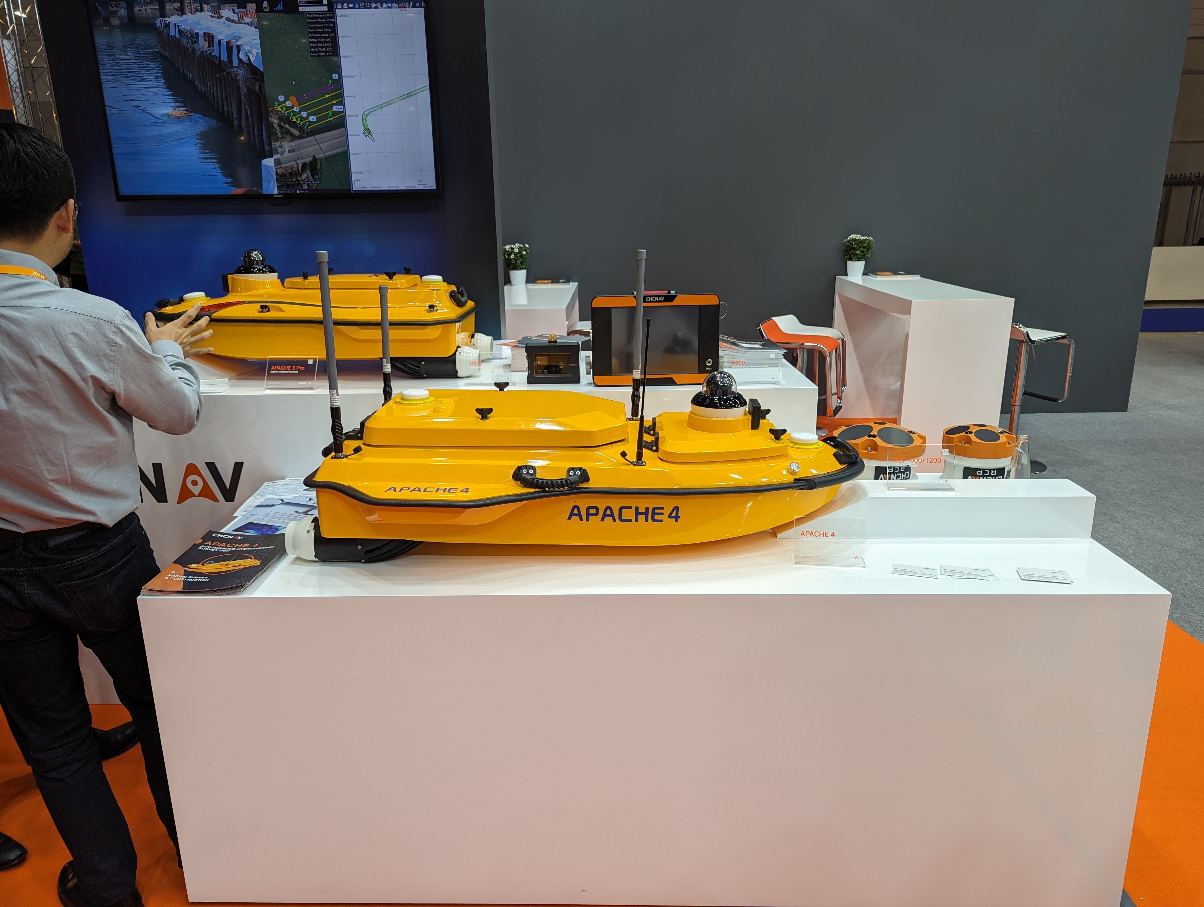
CHCNAV’s Apache 4 autonomous bathymetric vessel.
Visser told GPS World that his company had obtained from the German federal government sole responsibility to certify UAVs in Germany for commercial operations, including flights beyond visual line of sight (BVLOS).
Exail has launched the Atlans 3, its new Inertial Navigation System (INS) dedicated to land and air mobile mapping applications. The technology was unveiled at INTERGEO 2023.
The Atlans 3 is an all-in-one positioning and orientation system integrating unique micro-electro-mechanical systems. Fiber optic gyroscope (MEMS-FOG) hybrid technology and a dual-antenna RTK GNSS receiver are housed within one compact device.
The INS offers North-keeping capability at FOG-level performance across a variety of land and air mobile mapping applications. It delivers real-time heading, even in GNSS-challenging environments such as urban canyons, mountainous terrain, or forested areas. The lightweight INS is designed to meet the requirements of high-performance lidars mounted on vehicles where space and weight constraints are critical.
The Atlans 3 is designed to be quick and simple to install on all platforms. It offers efficient “set-and-forget” operations for a wide range of land and air applications including road and rail asset inventory, pavement condition survey, vehicle automation, HD mapping, ground-truth, airborne surveys and precision pointing.
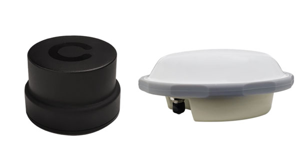
Harxon has launched its new survey GNSS antenna, HX-CSX600A, and helix antenna, HX-CUX615A, designed for high-accuracy positioning applications across the geospatial industry. These two antennas are set to debut at INTERGEO 2023.
Survey GNSS antenna HX-CSX600A
HX-CSX600A boasts a pre-filtered Low Noise Amplifier (LNA) offering exceptional out-of-band rejection, ensuring strong anti-interference performance even in challenging environments. It is designed for high-precision GNSS applications, including agricultural vehicles, small robots and surveying.
The new antenna offers reliable and consistent satellite signal tracking across a wide range of frequency bands, including GPS, GLONASS, Galileo, BeiDou, QZSS, IRNSS, SBAS, as well as L-Band correction services. With advanced multipoint feeding technology, HX-CSX600A maintains a stable phase center variation.
Built with an IP67-rated compact and ruggedized housing, this antenna is designed to withstand dust, rain, sunlight, shock and vibration. Its standard TNC-K connector and pole mount aims to simplify the integration process.
Helix antenna HX-CUX615A
HX-CUX615A is the housed version of Harxon’s HX-CUX012A, designed for UAVs. Its low profile design and simple integration process makes this antenna ideal for various UAV applications such as aerial photography, remote sensing, infrastructure inspection, traffic control and public security.
Equipped with a pre-filtered LNA, HX-CUX615A offers out-of-band interference rejection to mitigate unwanted electromagnetic interference and provide reliable GNSS signals for seamless integration into positioning solutions.
This light-weight antenna also adopts patented D-QHA (Dual-Quadrifilar Helix Antenna) technology, ensuring stable wide-angle circular polarization (WACP) performance. This results in low-elevation satellite tracking, while maintaining high gain and reliable signal tracking – even in challenging environments.
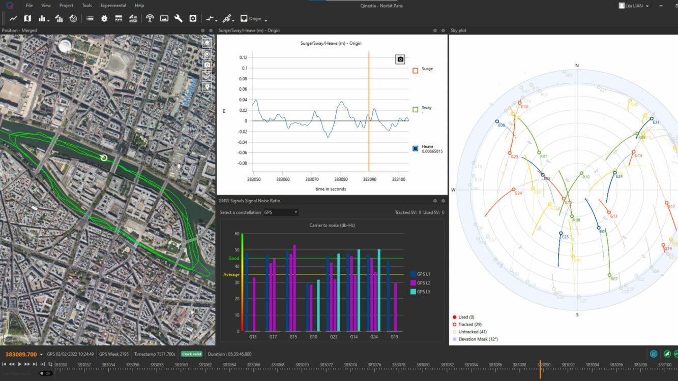
SBG Systems will release the newest version of its Qintertia technology, Qinertia 4, on November 7, 2023. This version introduces several innovative features that provide users with a complete solution for precise trajectory and motion analysis.
Qinertia is a post-processing software delivering better precision and reliability compared to RTK systems. Qinertia 4 has an enhanced Geodesy engine to boasts an extensive selection of preconfigured coordinate reference systems (CRS) and transformations, making it a versatile solution in applications that use diverse geodetic data, including land surveying, hydrography, airborne surveys, construction and more.
To tackle the challenges of variable ionospheric activity, the new technology uses Ionoshield PPK mode. This feature compensates for ionospheric conditions and baseline distances, allowing users to perform post-processing kinematics (PPK) even for long baselines or harsh ionospheric conditions.
Another addition to Qinertia 4 is extended continuously operating reference stations (CORS) network support. This feature offers users a vast network of 5000 SmartNet for reliable GNSS data processing.
Qinertia has more than 10,000 bases in 164 countries. This global coverage ensures that Qinertia remains a reliable and efficient solution, regardless of geographic location. In addition, users can import their own base station data and verify its position integrity with precise point positioning (PPP).
For data that cannot be processed using PPK, Qinertia 4 offers an alternative solution with its new tightly coupled PPP algorithm. This new processing mode, available for all users with active Qinertia maintenance, provides post-processing anywhere in the world without a base station, with a horizontal accuracy of 4cm and a vertical accuracy of 8cm.
Qinertia’s new functionalities will be demonstrated live at Intergeo 2023 in Berlin.
INTERGEO 2023 will take place Oct. 10-12, in Berlin, Germany, and GPS World staff will be in attendance. The main topics of the annual conference include Earth observation, maritime solutions, unmanned systems and building information modeling (BIM).
The three-day event will also cover the topics of GIS and artificial intelligence, metaverse and cloud applications, Earth observation and environmental monitoring, smart city, infrastructure BIM, digital twins, satellite services COPERNICUS and Galileo, 4D geodata, 3D cadastre, smart mapping applications, Geobasis 2030 and 3D point clouds illuminated.
In addition to international keynote speakers, the conference will focus on expert exchange and live experiences with panel discussions and networking events.
While GPS World will not have a booth, attendees can catch Matteo Luccio, the magazine’s editor-in-chief, on the show floor.
The INTERGEO conference program can be found here.