Trimble has introduced a new version of its smart water and wastewater management software — Trimble Connect version 1.5. The latest release of the cloud-based software includes a suite of applications that help water and wastewater utilities to deploy smart meters, repair leaks and reduce non-revenue water (NRW), locate and map critical infrastructure using geographic information system (GIS) technology, extend the life of aging assets, and improve worker safety and productivity.
Trimble Connect software version 1.5 can be configured and deployed quickly on a variety of rugged mobile devices, laptops, tablets and smartphones to automate field workflows and eliminate paper-based maps and field work tracking and management, the company said.
Over the last decade, water and wastewater utilities have made investments in GIS mapping systems and asset maintenance management databases to manage their pipes and assets that are installed over large geographic areas. A large number of these utilities have implemented the Esri ArcGIS as their primary GIS mapping system. Maintenance of the information is an ongoing task and requires that information about the location of assets and the work performed on these facilities is accurately collected in the field. Trimble Connect helps with this challenge by integrating Esri ArcGIS technology and allowing utilities to view and update maps, assign work, manage workflows and collect field data and mapping updates using a variety of mobile devices. When used with a Trimble GeoExplorer series or Trimble Juno T41G series handheld, workers can map assets with up to decimeter accuracy in the field, helping improve the quality of their critical infrastructure GIS and asset management data.
Trimble Connect integrates the latest Esri ArcGIS Server, mobile and ArcGIS Online map services. The software is designed to automate a variety of specific water and wastewater industry workflows through individual apps offered within the product. The new version provides standard core apps including Map Book, Meter Changeout, Leak Repair, Manhole Inspector, and Pipeline Mapper. In addition, an optional partner app developed for hydrant and valve inspection, called AFC Mapper, can be purchased from American Flow Control (AFC) and their distributors coupled with a Trimble rugged handheld.
In addition to the standard core apps, Trimble Connect version 1.5 includes:
Multi-mobile platform support including Apple iOS, Android, Windows Mobile and Windows 7/8 devices
Offline support for Android, Windows Mobile and Windows 7/8
Esri ArcGIS based Web, mobile GIS mapping and ArcGIS Online basemaps
Work management support for single and multi-asset work orders
Business rules for customer mobile form design
Support for over-the-air network data and background map updates
November 29, 2013, marks the 210th anniversary of the birth of Christian Doppler. His work laid down the fundamental concepts that enabled researchers at Johns Hopkins University in the United States to make observations on the signals of Sputnik I during the International Geophysical Year of 1957. From those observations more than 60 years ago, we can trace the development of GNSS as we know it today. The very genesis of GNSS drew on the combined science, technology, and innovation from Europe, the United States, and Russia. Today, GNSS is a truly global technology that has changed for the better the lives of an estimated one billion people.
2013 also saw a major milestone in the global history of GNSS with the announcement by the European Space Agency (ESA) that the Galileo system had generated its first position fix using operational space vehicles. Here at Trimble we have for some time been providing user equipment that is ready for the modernized, multiple-constellation environment emerging in the coming years. It is still exciting to see the plans of the GNSS operators gradually become a reality, whether it is the ongoing deployment of Galileo and BeiDou or the modernization of GPS and GLONASS. There is no doubt that GNSS users worldwide will benefit significantly from these new developments, and it is natural to expect that we will see continued user-driven adoption and integration of these systems in the year ahead, together with new applications and services that make full use of the expanding GNSS capabilities.
Global Addiction to Accuracy
We have come to expect — if not demand — that technologies continuously evolve to become faster, smaller, and more cost-effective, while also providing expanded functionality and benefits. For GNSS, this expectation includes increased accuracy and precision for a growing proportion of the total user base, together with a desire to determine location in more places or, ultimately, ubiquitously.
From a technological perspective, the trend to increased accuracy is moving beyond local or regional land- or satellite-based differential augmentation toward global networks and services. New technologies such as Trimble RTX use data from a global network of GNSS stations together with global connectivity and communications to facilitate precise point positioning without the need to connect to local or regional reference station networks. Such capabilities simplify the user’s experience with precise positioning, while at the same time vastly expanding the areas on Earth where such positioning can be quickly and conveniently carried out.
Over the past decades, high-precision GNSS positioning has been adopted by increasingly larger numbers of users in the context of end-to-end work-process solutions in industries from agriculture to construction, surveying and mapping, energy, mining, utilities, transportation, and government, to name but a few. With assets, workers, and work sites spread over large geographic areas, these industries and operations have transformed how their work is done through the use of systems that incorporate real-time location information. While we should expect adoption and advancement in these areas to continue due to the compelling economic, safety, and environmental benefits provided, we should also expect to see increasing adoption of high-precision GNSS positioning in new applications such as intelligent transportation and within some proportion of the consumer user base. Accuracy is, after all, addictive.
Availability, Too. Along with accuracy, availability of position is also proving to be addictive; once we come to depend on location-enabled systems in our professional and personal lives, our needs and expectations will naturally tend toward that of continuous availability at all times and regardless of location. Although new constellations with more satellites and new, stronger signals help in this regard, augmentation of GNSS plays a key role on the path to more robust ubiquity. From a Trimble perspective, many of our new product launches during the past year incorporated deep integration of multiple measurement technologies. New systems combine GNSS with inertial measurement units, gyros, tilt sensors, seismometers, optical measurement, imaging systems, lasers, and other sensors or technologies, all enabling location and movement determination (increasingly in three dimensions) of more objects in more places — including, in some cases, even inside buildings. Looking to the future,we can expect the appetite for ubiquitous positioning to continue unabated.
Multiple sensors are also used to collect non-geographic information. Increasingly, innovation is taking place at the intersection and aggregation of many different types of data, providing new insights and enabling more informed, more timely, and more insightful decisions across almost every facet of human activity. GNSS is rapidly expanding its role as an enabling technology in this regard. While we know that delivering consistently accurate positions is a decidedly nontrivial achievement, those positions are often just one component of increasingly large and complex endeavors. In fact, much of the innovation today lies in applications that enable new, more efficient approaches to work and enterprise management, and in the creation of new and powerful analytics from aggregated data.
Global Utility, Global Business
2013 marks another important anniversary: GPS officially reached Initial Operating Capability twenty years ago on December 8, 1993. In his 2011 State of the Union address, U.S. President Barack Obama cited GPS, along with the Internet, as key examples of how government-funded fundamental research can stimulate innovation and create whole new industries. The combination of those two technologies has transformed our lives in ways even the early visionaries may not have imagined. The U.S. government has contributed to the global success of GPS in ways beyond technological innovation. Following the 1983 Korean Airlines 007 disaster (caused in part by inaccurate navigation), President Reagan declared that GPS should be free and available to all, providing a stable policy foundation upon which successive U.S. administrations have continued to build, increasingly recognizing the importance of civilian GPS applications.
Importantly, the United States strengthened this open-access policy framework by publishing the Interface Control Document for GPS, which enabled entrepreneurs and innovators anywhere in the world to bring to life their ideas about how this new technology in space could be used on Earth. For the most part, other governments have followed U.S. leadership in announcing predictable policy access to worldwide satellite positioning and timing availability, allowing innovation to take place wherever it may. In the process it spawned a truly global industry.
Technology alone has not achieved the global impact of GNSS. Rather, it is the combination of technology, a transparent, stable policy environment conducive to global innovation and adoption, and the economics of a global market that together have led to so many people today enjoying the benefits that GNSS provides. Such alignment is equally important for the future: just as GNSS from the beginning built upon knowledge and achievement from around the world, its full international potential will be best realized through global, user-driven innovation, vibrant international entrepreneurship, and robust open markets. Given that we are still far from reaching that full potential, there is good reason for us all to have great expectations of GNSS operators, the industry, and the user community in 2014 and beyond.
Peter O. Large joined Trimble in 1996 and has served as a vice president and a member of the executive committee since 2010. He holds a BSc (Hons) in surveying and mapping science from the University of Newcastle upon Tyne, UK, and an M.S. in management from Stanford University.
Trimble has announced a new feature for its RainWave precipitation monitoring solution for agriculture. As part of the Connected Farm solution, the new feature adds actual rainfall activity in 10-minute increments plus accumulated rainfall over a 24-hour period. With this comprehensive rainfall information, farmers can have a better understanding of the rainfall intensity, which can be used to make more informed decisions for irrigation and other farming operations.
For example, if RainWave information shows that a large amount of rain fell in a short period of time, much of that rainfall may have run off the field and be unavailable to the crop. In contrast, if the information shows a slow steady rain, farmers may assume that the rainfall has a better chance of being absorbed in the soil and can be available to the crop.
“With RainWave’s added functionality, Trimble is placing another valuable piece of information in farmers’ hands,” said David Fitzpatrick, business area director for Trimble’s Agriculture Division. “By providing a better understanding of how rainfall may have impacted soil moisture levels, farmers can optimize their irrigation planning, fleet management and timing of materials application for nutrient and pest management.”
The RainWave solution enables farmers across the U.S. to set up virtual rain gauges by entering GPS coordinates for identified locations in order to receive a rainfall report for those locations. Since on-site rain gauges are not needed, farmers no longer need to monitor dispersed gauges or manually track precipitation. Farmers are able to obtain the RainWave information through their Connected Farm dashboard, a Web portal that provides one centralized location for farmers to view key information impacting their operations.
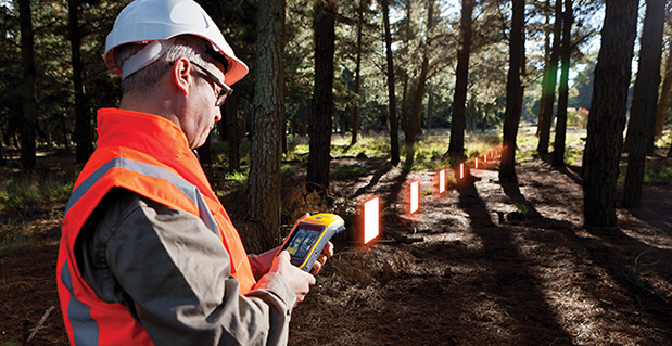
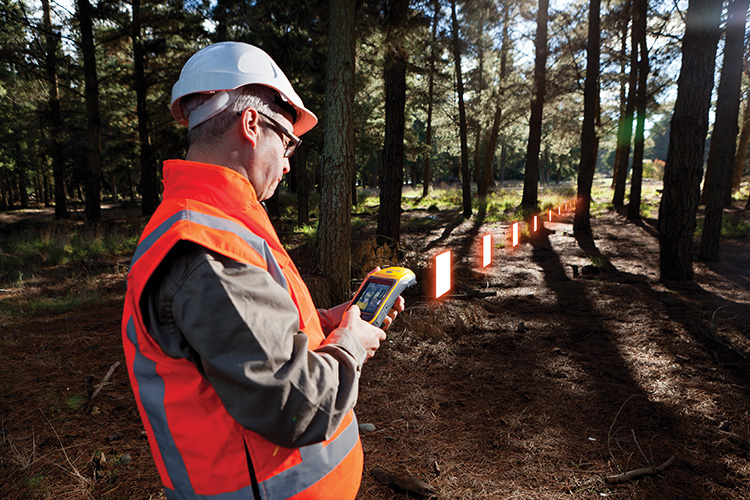
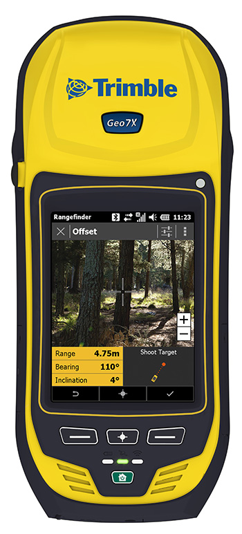
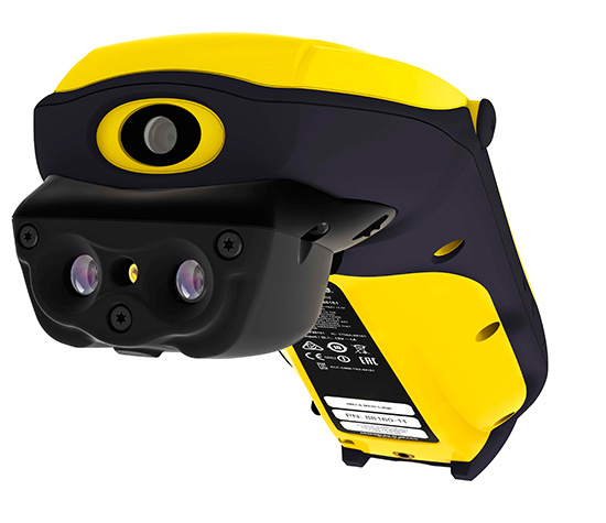
Trimble has introduced the next generation of its Trimble GeoExplorer data collection solution. The new Geo 7X includes an integrated laser rangefinder module, extended GNSS capabilities and improved hardware performance. Together with robust field and office software, the new Trimble Geo 7X handheld can enhance productivity in difficult physical conditions and challenging GNSS environments.
When faced with either obstructed satellites or inaccessible locations, GIS professionals now have the geospatial data collection tools they need in a single package, Trimble said. For times when occupying a position isn’t possible, users can take advantage of Trimble’s new Flightwave technology. With Flightwave technology, users can capture offset measurements from the Geo 7X’s rangefinder module for direct integration with Trimble data collection software. Users point and shoot to log the position, avoiding dangerous conditions or right-of-way challenges. In addition, Trimble’s field-proven Floodlight technology enhances field productivity when heavy overhead cover obstructs satellite signals.
The Geo 7X is compatible with existing and planned GNSS satellite systems — including GPS, GLONASS, Galileo, QZSS and BeiDou — to maximize productivity with additional satellites and ranging signals.
Featuring a new 1 GHz processor and 4 GB of memory running Microsoft Windows 6.5 Professional operating system, the Geo 7X offers enhanced computing performance. Other standard features include a 4.2 inch sunlight readable LED touch display and a 5 MP camera for geo-tagging assets. For wireless connectivity, the integrated modem allows users to send and receive data via GSM networks as well as Verizon’s CDMA network in the U.S. And with its IP65 rating, the rugged handheld GNSS receiver is sealed against water and dust.
With the introduction of the Geo 7X, Trimble also delivers updates to its field and office software portfolio to extend Trimble’s end-to-end data collection solutions with new software workflows and compatibility. In addition to the field-proven Trimble TerraSync and Positions software, the Geo 7X now supports the customizable data collection workflows of Trimble TerraFlex software. Consisting of mobile software and Cloud services, TerraFlex offers a fast and efficient way to collect, process and manage data. Field data is automatically synced with a central server to streamline office operations and drive higher productivity.
”We believe that true productivity is being able to map assets — the first time, every time and anywhere. We’ve built upon our productivity-enabling Floodlight technology and pushed it forward several steps,” said Alain Samaha, business area director of GIS and geospatial software solutions for Trimble’s Geospatial Division. “Users now can position themselves in the optimal location and accurately measure assets remotely with a single, integrated device together with simple software workflows. The Trimble Geo 7X allows mobile GIS users to be productive wherever they need to work.”
The Trimble Geo 7X and supporting software are expected to be available in fourth quarter of 2013 through Trimble’s authorized GIS Distribution Channel.
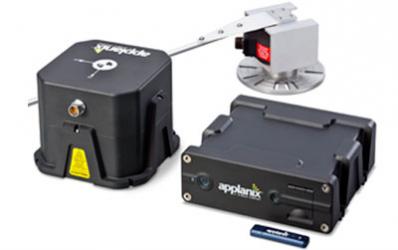
Applanix, a mobile mapping and positioning company, has introduced new versions of its positioning and orientation systems for airborne and land-based mapping — the POS AV 610 and POS LV 610. Delivering the same industry-leading performance as previous versions of POS AV and LV, the new systems use next-generation commercial inertial technologies that are offered globally.
Applanix POS AV and LV products integrate precision GNSS with advanced inertial technology (accelerometers and gyroscopes) to provide uninterrupted measurements of the position, roll, pitch and true heading of moving vehicles. Geospatial projects using POS can be completed more efficiently, effectively and economically. The POS AV 610 and POS LV 610 offer new advantages to customers:
Global availability: commercial technology.
Smaller and lighter: achieved by integrating a new state-of-the-art FOG (Fiber Optic Gyro) based Inertial Measurement Unit (IMU).
Exceptional performance with Applanix SmartCalTM software: SmartCal is a new compensation technology designed to achieve unrivalled performance from IMUs manufactured specifically for mobile mapping applications.
Cost efficiency: exceptional accuracy, even in demanding conditions, at unprecedented price points.
POS LV 610 and AV 610 are also available to systems integrators in the form of an OEM board set called the Trimble AP60. The Trimble AP is a series of embedded GNSS-Inertial OEM boards that provide both continuous mobile positioning in poor signal environments and high-accuracy direct georeferencing of imaging sensors. The AP series is ideal for a variety of commercial mobile positioning and orientation applications including airborne and terrestrial mapping and guidance for unmanned vehicles.
“The latest versions of POS LV and POS AV take Applanix’ state-of-the-art positioning technologies worldwide for land and air applications,” said Steve Woolven, President of Applanix. “Wherever mobile mappers operate, the new POS technology provides users with accurate, reliable and robust position and orientation solutions.”
POS AV 610, POS LV 610 and Trimble AP60 are available now through the Applanix sales network.
Trimble announced today new additions to its aerial imaging portfolio — the Trimble AX60, a new airborne LIDAR system; and an updated version of its Inpho processing software.
The announcement was made today at Intergeo 2013, being held this week in Essen, Germany.
The Trimble AX60.
The Trimble AX60 is a versatile system that can be operated at up to 15,500 feet above ground level (AGL), which meets the requirements for aerial survey projects such as wide area mapping, corridor mapping and remote sensing. Together with integrated flight planning and analysis software tools, the platform has been specifically designed as end-to-end solution that provides enhanced mission flexibility, rapid and efficient point cloud capture, excellent resolution, in-service reliability and high-productivity workflows. The Trimble AX60 can be installed on either fixed wing or rotary aircraft.
The AX60 has a 400-kHz laser pulse repetition rate (PRR) with a single channel downward-looking laser. An optional, fully calibrated 80-megapixel camera with forward motion compensation can be added. The camera is integrated into the sensor head package and harmonized with the laser system so that it does not need re-calibration each time the solution is fitted to an aircraft. Another key feature is Trimble’s rotating polygon mirror technology for beam deflection that can allow survey missions to be completed faster. This technology provides higher accuracy and a uniform distribution of laser points across the entire field-of-view to widen the usable swath width. Operators can reduce track overlap or duplication, or fly at higher altitudes to achieve a given resolution. Together with a high precision positioning system, integral power supplies, and an in-flight monitoring tool, the Trimble AX60 can allow operators to lower the complexity of airborne LIDAR surveys while increasing the quality of the output.
“The performance, operational flexibility and reliability of the Trimble AX60 make it an ideal solution for aerial survey companies,” said Phil Sawarynski, business area director of Imaging Solutions for Trimble’s Geospatial Division. “In addition, the Trimble AX60 has been designed as a true end-to-end solution, which includes field-proven Trimble flight planning software and Trimble Inpho analysis software. Since the hardware and software are all supplied by Trimble, operators can have confidence that the complete solution works together seamlessly, and that the flight planning and post-mission analysis suites can enable them to provide a high quality service to their customers.”
In conjunction with the new airborne laser scanner launch, Trimble also announced its Inpho version 5.6 processing software suite. Version 5.6 now includes the UASMaster module, which has been designed for the complete processing of data acquired by remote piloted aircraft systems (RPAS/UAS). The module georeferences RPAS/UAS images and generates point clouds and othophoto mosaics that allow users to create high quality deliverables for CAD and GIS applications. The UASMaster module is fully compatible with Inpho photogrammetric software modules.
The Trimble AX60 solution is expected to be available in the first quarter of 2014 through Trimble’s Geospatial Division distribution network. The Inpho version 5.6 and UASMaster is expected to be available in the fourth quarter of 2013.
Trimble introduced today the latest version of its deformation monitoring software, Trimble 4D Control version 4.2. The new version of the monitoring software delivers enhanced communications with the Trimble NetR9 and new NetR9 Ti-M GNSS receiver, REF TEK seismic sensors and the Trimble S8 total station. It also supports geotechnical sensors, weather stations, level data and it provides velocity and trend computations as well as a calculation facility for mathematical operations. The interactive Web interface provides advanced alarms, data visualization and analysis tools. Site access is controlled by user login credentials.
The announcement was made today at Intergeo 2013, being held in Essen, Germany, October 8-10.
Trimble NetR9 Ti-M. Trimble also introduced a dedicated GNSS monitoring receiver, the Trimble NetR9 Ti-M, designed for real-time monitoring applications. This instrument is the fourth-generation of the proven Trimble NetR9 series of GNSS reference receivers, and is specifically designed for the monitoring market and supported by Trimble 4D Control software.
Trimble REF TEK Sensors. Following the acquisition of REF TEK, now a division of Trimble and a provider of seismic sensors and data recording instruments, support for REF TEK accelerometers has been included in Trimble 4D Control version 4.2. Different variants of peak acceleration that are used in monitoring the effects of vibration on structures such as micro-seismic activity, proximity blasting or impact piling can be visualized and alarmed in Trimble 4D Control.
Trimble 4D Control is a fully scalable and comprehensive software solution for both real-time and post-processed monitoring projects. The software solution is ideal for the long-term, automated monitoring of dams, bridges, buildings, support piers, large-scale construction and excavation sites, open pit mines, landslides, tunnels and other structures. Real-time management and control of the monitoring system is available via the Trimble 4D Control Web Interface on-site, online and around the clock from any location with Internet or Intranet connectivity.
“To date, this advanced technology has only been available to end users of an automated monitoring system. We recognized the need to provide this functionality across the full spectrum of monitoring applications,” said Ulrich Vollath, general manager of Trimble’s Infrastructure Division. “We are pleased to announce the launch of Trimble 4D Lite, a cloud-based subscription service which will make this solution available to small- and medium-sized monitoring projects. With the introduction of 4D Lite, Trimble’s monitoring solutions are now available for the full spectrum of monitoring projects, from small, non-permanent, campaign monitoring projects through to permanent, fully automated monitoring systems.”
Trimble 4D Lite – Advanced Cloud Monitoring Service. 4D Lite is a cloud-based application that is designed with an interface familiar to existing Trimble monitoring technology users. 4D Lite is designed for surveyors, engineers and scientists to perform campaign monitoring of data/time series without the need to integrate directly with onsite hardware and sensors. Trimble 4D Lite can be used to meet campaign monitoring needs of installations on dams, bridges, mines, landslides, buildings and other natural and man-made hazards or structures using sensors to monitor health. Data can be integrated from a wide range of sensors. The data can be visualized and analyzed on a variety of interactive charts and scatter plots and the sensors can be viewed in context with the structure using a variety of backdrops including maps, plans or photographs.
Trimble 4D Control version 4.2, the NetR9 Ti-M GNSS receiver and the 4D Lite monitoring service are available now from Trimble’s worldwide Infrastructure distribution network.
Trimble announced today several enhancements to the Trimble R10 GNSS Surveying System designed to drive field productivity to a new high. With sophisticated tilt-compensation technology, CenterPoint RTX correction service support, and updated field and office software, the R10 platform demonstrates Trimble’s commitment to driving improved surveying productivity.
The announcement was made at Intergeo 2013, being held October 8-10 in Essen, Germany.
“Innovations in techniques such as our tilt compensation technology can have a pervasive impact on the everyday surveying experience,” said Elmar Lenz, business area director of GNSS Solutions for Trimble’s Geospatial Division. “With our innovative approach to total surveying workflow, Trimble is redefining the way surveying work is done.”
The Trimble R10 is now augmented to further speed GNSS field work. With its new internal tilt-compensation, Trimble SurePoint technology takes field efficiency to the next level. The system will automatically adjust for pole-tilt up to 15 degrees from plumb, saving time and reducing fatigue. With tilt compensation, surveyors can now utilize GNSS in more situations and with 100 percent measurement traceability.
In addition, Trimble introduced its high-accuracy correction service, CenterPoint RTX, into the geospatial market with support in the Trimble R10. Powered by Trimble RTX technology, CenterPoint RTX is a subscription service that delivers real-time 4 centimeter (1.5 inch) or better corrections via satellite directly to the receiver without requiring the use of a base station, VRS network, or investment in additional hardware.
Both Trimble Access field software and Trimble Business Center office software have been updated to streamline data flow and automate data processing. Faster in the field and more flexible in the office, Trimble’s premium GNSS surveying system enhances the entire surveying workflow.
The updates to Trimble R10 GNSS System, CenterPoint RTX service support, Trimble Access version 2013.40 and Trimble Business Center version 3.10 are expected to be available in the fourth quarter of 2013 through Trimble’s Geospatial Division distribution network. For current R10 users, the tilt-compensation feature and CenterPoint RTX support will be available through a free firmware update.
Trimble announced today that its Trimble CenterPoint RTX correction service will be available to survey and land administration professionals around the world. Powered by Trimble RTX technology, the GPS, GLONASS and QZSS enabled correction service can offer better than 4 centimeter (1.5 inch) repeatable horizontal accuracy, without requiring the use of a base station or local VRS network.
The announcement was made today at Intergeo 2013, being held this week in Essen, Germany.
In addition to previously announced Agriculture devices, the CenterPoint RTX correction service is now compatible with the Trimble ProXRT for Land Administration and the Trimble R10 GNSS receivers. The worldwide subscription service is expected to be available to geospatial users in the fourth quarter of 2013.
Delivered via L-band satellite, CenterPoint RTX is designed for geospatial professionals who are not using RTK as the primary correction source. Advantageous in remote areas that lack local infrastructure and/or cellular coverage, the corrections are delivered directly to the GNSS receiver. No additional hardware, including radios, antennas, or even cellular data plans, is required to use the correction service.
“By combining global coverage, fast initialization times, and high-accuracy correction data, Trimble CenterPoint RTX offers geospatial professionals unprecedented operating freedom,” said Patricia Boothe, general manager of Trimble’s Positioning Services Division. “We are committed to offering field-proven positioning corrections to address a variety of users’ needs across applications and markets, starting with agriculture and now reaching into the geospatial markets.”
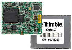
Trimble today introduced the Trimble BD930 module as part of its GNSS OEM portfolio. This small module features triple-frequency support for GPS and GLONASS plus dual-frequency support for BeiDou and Galileo constellations. Capable of receiving a wide range of commercially available GNSS signals, the 220-channel BD930 takes advantage of all available signals to provide optimal and reliable RTK centimeter positioning.
The announcement was made today at ION GNSS 2013 Conference and Exhibition.
“The OEM and system integrator communities trust Trimble to supply high performance, accurate and reliability positioning solutions for their systems,” said Ed Norse, portfolio manager of Trimble’s GNSS OEM modules. “The Trimble BD930 delivers the latest GNSS technology in an easy-to-integrate form factor for demanding conditions and applications such as high-precision navigation and control, robotics and lightweight unmanned vehicles.”
The triple-frequency Trimble BD930 (measuring 41 x 51 millmeters) is a small, yet powerful GNSS module specifically designed for applications requiring high accuracy in a compact package. Form-Fit-Function compatible with the Trimble BD920 receiver, the module tracks all available GNSS constellations including GPS, GLONASS, Galileo and BeiDou.
The BD930 is designed for all levels of accuracy with an advanced engine that provides GNSS, DGNSS and RTK positioning in challenging environments such as under tree canopy and urban canyons. The BD930 allows for easy integration and rugged dependability. Flexible connectivity options — Ethernet, RS232 or USB — provide fast data transfer and easy configuration via standard Web browsers. External 10 MHz frequency input is supported for advanced applications.
The Trimble BD930 module is expected to be available in the fourth quarter of 2013 through the Trimble Precision GNSS + Inertial worldwide sales channel.
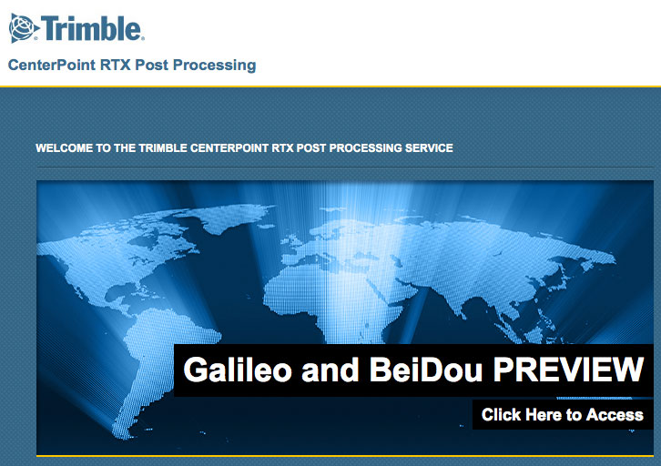
The preview version of Trimble’s CenterPoint RTX post-processing service, enabling GNSS observations using available Galileo and BeiDou MEO satellites.
Trimble announced today a Preview version of its CenterPoint RTX post-processing service, enabling GNSS observations using available Galileo and BeiDou Middle Earth Orbit (MEO) satellites. Powered by Trimble RTX technology, the free CenterPoint RTX post-processing service provides better than centimeter level positions.
The announcement was made today at ION GNSS 2013 Conference and Exhibition.
The existing CenterPoint RTX post-processing site uses data from the GPS, GLONASS, and QZSS satellite systems. Through a link accessible from the post-processing website, users can enter a Preview site and derive positions that also use data from available open service Galileo and BeiDou MEO satellites.
“With the addition of Galileo and BeiDou MEO support, we offer researchers, scientists and academics the opportunity to evaluate and experiment with results from these evolving satellite constellations,” said Patricia Boothe, general manager of Trimble’s Positioning Services Division. “We are committed to continuing to advance CenterPoint RTX post-processing and the underlying Trimble RTX technology to enable ever higher accuracy positioning solutions.”
Trimble CenterPoint RTX post-processing is a cloud-based service accessed through www.TrimbleRTX.com. Users around the globe can upload static GNSS observation data and receive positioning corrections calculated in the well-defined International Terrestrial Reference System (ITRF) 2008 reference frame. The post-processed solution can be transformed to a variety of regional reference frames by selecting a coordinate system and tectonic plate.
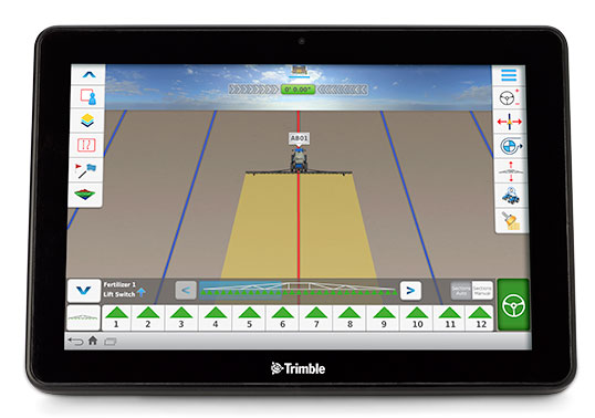
Trimble has launched the Connected Farm dashboard, which provides one centralized location for farmers to view key information impacting their operations. With this information, farmers will be able to make better daily decisions based on the latest data. The Connected Farm dashboard is customizable and accessible via Internet-enabled devices such as desktop and notebook personal computers, smartphones and tablets, and Trimble’s new TMX-2050 display.
Trimble TMX-2050 display.
The TMX-2050 display is a next-generation display built on the Android operating system. It offers an intuitive interface that enables farmers to easily implement precision agriculture solutions as their business grows. Its flexible software platform improves the ability for a customer to seamlessly add applications to their operations while the modular architecture allows for future expandability.
The TMX-2050 display is an addition to Trimble’s existing line of guidance displays, which include the EZ-Guide 250 lightbar guidance system, CFX-750 display, and FmX integrated display.
The Connected Farm dashboard will allow farmers to:
Check daily rainfall totals for each virtual rain gauge—without the use of physical rain gauges. (Made possible by Trimble’s acquisition of RainWave’s assets). This will allow a farmer to reprogram his irrigation system based on the previous evening’s rainfall, optimizing the use of water.
View the weather forecast weekly, daily, or hourly for a given location including temperature, humidity, chance of precipitation and wind speed. For example, wind speed will allow a farmer to plan when to spray a given field.
Set up a Doppler radar map to show upcoming weather patterns for their area. This will allow a farmer to assess in real time whether or not to continue with a current activity.
Check the latest commodity prices. Farmers will be able to select the commodities that matter to them and list them based on personal priority.
View farming operations data. For example, if the farmer is viewing yesterday’s planting activities, the dashboard may show population, singulation, skips and doubles.
Monitor a fleet by tracking the location and status of vehicles and receive geo-fence and curfew alerts. Farmers also can link through to Trimble’s new Connected Farm fleet app to add landmarks or for turn-by-turn directions to locate vehicles from their current position, and view historical positions.
View a boundaries map created with Trimble’s Connected Farm scout app.
Following the completion of the recently announced IQ Irrigation asset acquisition, irrigation pivot data is expected to be available on the Connected Farm dashboard in New Zealand in the fourth quarter of 2013 and the U.S. in the first half of 2014.
“With the Connected Farm dashboard, farmers can quickly see a snapshot view of their latest field operation as well as key information that may impact today’s activities such as rainfall, commodities, and the day’s weather forecast,” said Joe Denniston, vice president for Trimble’s Agriculture Division. “With this information available in one convenient central location through Connected Farm, farmers can access the information they need to make the best daily decisions about their farm. Since the dashboard can be accessed from Internet-enabled devices, farmers can make these decisions from potentially any location at any time.”
The Connected Farm dashboard is a free web portal and is currently available. To view rainfall totals, monitor pivot irrigators (when available), or for fleet management, customers will need to purchase these services.
On August 27, Trimble acquired the assets of privately-held RainWave, LLC and Hydro-Engineering Solutions, LLC of Auburn, Alabama. The acquisitions will help to extend the monitoring and reporting capabilities of Trimble’s Connected Farm solution and strengthen its water management expertise. Financial terms were not disclosed.
RainWave provides precipitation monitoring services for agribusiness, construction and engineering, government and consumer industries. RainWave will be part of the Connected Farm solution, which simplifies and integrates operations management by providing information exchange across the entire farm. This RainWave service will provide farmers across the U.S. with vital rainfall data they can use to better manage their crop production.
Using RainWave, farmers can set up a virtual rain gauge by entering GPS coordinates for identified locations to receive a rainfall report for those locations. Since on-site rain gauges are not needed, farmers no longer need to monitor dispersed gauges or manually track precipitation. The farmer will now be able to obtain this rainfall information through their Connected Farm dashboard. RainWave’s convenient, accurate rainfall information allows farmers to make better management decisions by optimizing irrigation plans and application timing, and comparing yield against rainfall to plan for next season’s crop. This results in savings of time and water usage.
Hydro-Engineering Solutions is a civil engineering company that specializes in hydrology and hydraulics. The company provides high-quality engineering services to federal, state and local governments as well as commercial entities, and has extensive experience with streams and rivers. Hydro-Engineering’s expertise in hydrology and hydraulics modeling is expected to strengthen Trimble’s water management solution in watershed analysis for both drainage and irrigation.