Trimble RealWorks version 8.0 software will include a new 3D database engine, automated targetless registration and Web viewing capability incorporating RealWorks’ Scan Explorer interface. The new version is due to be released in June.
The new enhancements will allow surveyors, contractors, engineers and geospatial professionals to rapidly process 3D laser scanning data and expedite the creation of deliverables for their clients, increasing productivity and reducing costs, Trimble said.
The new 3D database engine in Trimble RealWorks version 8.0 will allow up to five times more data to be visualized and managed, compared to Trimble RealWorks version 7.2. The ability to handle larger data sets greatly increases usability and productivity for customers capturing data with 3D laser scanners such as the Trimble TX5 and Trimble FX.
The automated targetless registration function, together with additional workflow enhancements, will provide further productivity gains for customers. The automated targetless registration function automatically identifies planar objects in each scan and matches the planes from multiple stations, creating a combined data set. The function enhances productivity in the field by eliminating target placement prior to data capture in applicable environments. Office processing time is also reduced by the fully automated function.
Sharing of data with clients has been enhanced by the addition of a Publisher function within the Trimble RealWorks software that allows projects to be custom packaged for viewing via Microsoft Internet Explorer. The Scan Explorer interface, embedded inside a HTML web page, allows clients to navigate and explore the scan data as well as take measurements and add notes.
“Software is an integral part of Trimble’s 3D laser scanning solutions and is essential to extract information from 3D data captured in the field,” said Tim Lemmon, marketing director of Trimble. “The new version of Trimble RealWorks software significantly improves our customers’ productivity in processing field data, extracting information and preparing deliverables for their clients.”
The announcement was made today at SPAR International 2013, the leading conference for 3D data capture, processing and delivery technologies.
Trimble has launched a new mobile mapping product for hunters and anglers. The launch includes two smartphone apps (Trimble GPS Hunt and Trimble GPS Fish), one tablet app (Trimble GPS Maps), and a new Website — GPSHuntFish.com.
The offerings combine the latest in mobile GPS technology and Trimble’s exclusive outdoor maps to help sportsmen plan trips, navigate in remote areas, record GPS information, and privately share details with friends.
“We are excited to launch a comprehensive solution for hunters and anglers,” said Rich Rudow, general manager at Trimble Outdoors. “Now hunters can scout a future hunt at GPSHuntFish.com then send maps and GPS details to their iPhone, Android, or iPad to use in the field. In addition, they can print custom waterproof maps that compliment the digital maps displayed in the mobile apps.”
The launch includes:
Trimble GPS Hunt App
Runs on: iPhone and Android phones
Find hunting spots on detailed outdoor maps, navigate in remote areas and track wildlife. The Trimble GPS Hunt app uses the GPS built into smartphones to track position in the field—even in areas without a cell or data connection. In addition, users can mark waypoints, record tracks, view weather forecasts, see sun and moon phases, and view compass and trip details.
Trimble GPS Fish App
Runs on: iPhone and Android phones
Use Trimble GPS Fish to record fishing trips and keep a report of daily catches. Pinpoint the exact location of each catch, take photos, record GPS tracks, and view detailed street, topo and terrain maps. Use the app to return to previous fishing hotspots. In addition, with an Elite membership, users have access to more than 6,900 lake maps showing 10-foot lake depth contours.
Trimble GPS Maps App
Runs on: iPad
Plan and organize your next hunting trip or fishing trip with the Trimble GPS Maps app. Research hunting lands, find fishing spots and scout access roads on your iPad. This app allows users to fade between street, aerial and topographic maps, and instantly copy-and-paste GPS coordinates onto the digital maps.
GPSHuntFish.com is a portal for all of the Trimble hunting and fishing apps. In addition, users can view and store their trips, view maps in large format, and print maps at home or as a custom print by MyTopo.com. All trips created in the Trimble fishing and hunting apps are stored in the Trip Cloud, an online service that auto-syncs trips between a computer, smartphone and tablet device.
Trimble Elite
Works with Trimble GPS Fish, Trimble GPS Hunt, Trimble GPS Maps, GPSHuntFish.com
Trimble Elite members have access to public land boundaries for 46 states, lake maps for 6,900 lakes, forest road overlays for 134 national forests, real-time weather maps, online trip planning tools and discounts off printed maps. In addition, users can pick from a library of 3,000 Mega Offline Map bundles. These topo map bundles can be downloaded by state, county, or hunt unit and be accessed on the mobile device in remote areas, even with no cell or data connection.
How to Buy. Trimble GPS Hunt and Trimble GPS Fish are available in the Apple App Store and Google Play store. Trimble GPS Maps are available in the Apple App Store. Each app comes in a free or pro version for $4.99. The Elite membership is available for purchase in all the apps and at GPSHuntFish.com for $29.99/year or $2.99/monthly.
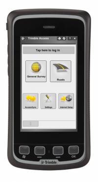
Trimble has introduced an all-in-one device for mobile communications and surveying data collection — the Trimble Slate Controller. The Trimble Slate Controller combines the convenience and ease-of-use of a smartphone with rugged durability. Optimized for Trimble Access field software and the Trimble R4 GNSS receiver, the Trimble Slate Controller supports a surveyor’s everyday workflows.
“Surveyors require mobile, rugged solutions that can readily withstand and perform in the toughest of conditions,” said Erik Arvesen, vice president of Trimble’s Survey Division. “With the introduction of the Trimble Slate Controller, we are providing a rugged handheld device designed to run survey workflows while also delivering the capabilities and convenience of a smartphone.”
Offering voice, SMS text, and 3.75G cellular data transfer capabilities on GSM cellular networks worldwide, the rugged Trimble Slate Controller enables enhanced connectivity in the field. Its wireless communication capabilities keep surveyors connected to the office. An integrated 8-megapixel camera offers enhanced job documentation and point attribution by providing geotagged, high-quality digital photos.
The Trimble Slate Controller’s slim, ergonomic design is easy to hold while its screen provides superior sunlight readability enabling all-day use by survey professionals. Designed to withstand even tough conditions, a 4.3-inch capacitive touch Gorilla glass display covers the entire front surface, increasing readability without sacrificing durability.
Trimble Access field software available on the Trimble Slate Controller offers a variety of features and capabilities to streamline topographic, stakeout, control and other surveying applications. Partnered with Trimble Access and the Trimble R4 GNSS receiver, the Trimble Slate Controller provides a dedicated GNSS solution that is effective for both real time and post-processed GNSS surveys, Trimble said.
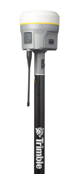
Trimble announced today functionality updates to its integrated GNSS survey receiver portfolio, which includes the Trimble R4, Trimble R6, Trimble R8 GNSS systems and is rounded out by the recently released Trimble R10 GNSS System (pictured at right).
The updates include increased satellite tracking and real-time kinematic (RTK) performance. These improvements modernize the integrated receiver portfolio to add functionality, flexibility and capability as well as more options for surveyors, Trimble said.
“With the introduction of the next-generation Trimble R10 GNSS system, we felt it was an ideal opportunity to modernize the complete integrated receiver portfolio,” said Erik Arvesen, vice president of Trimble’s Survey Division. “The additional functionality in the Trimble R4, R6 and R8 provide surveyors with more capability, flexibility and additional receiver options to meet their ever-changing business needs.”
Trimble R8 GNSS System. The Trimble R8 includes integrated Trimble Maxwell 6 ASICs offering 440 channels. Powered by Trimble 360 technology, the Trimble R8 provides consistent and reliable tracking of signals for all existing GNSS constellations and augmentation systems, including GPS, GLONASS, Galileo, BeiDou and QZSS. Using the Trimble R8, surveyors can connect directly to the controller, receive RTK network corrections and access the Internet via comprehensive communication options.
Trimble R6 GNSS System. Featuring Trimble R-Track satellite tracking technology, a Trimble Maxwell 6 ASIC with 220 channels and support for all GPS and QZSS signals with GNSS upgrade options, the Trimble R6 provides surveyors with a completely scalable and flexible solution. The Trimble R6 supports GPS L1, L2, L2C, and L5 signals and QZSS as standard and offers upgrade options to support GLONASS, Galileo and BeiDou signals. The Trimble R6 delivers the accuracy and reliability required for precision surveying with superior tracking and RTK performance.
Trimble R4 GNSS System. Designed for use with the new Trimble Slate Controller and Trimble Access field software, the Trimble R4 GNSS System provides a dedicated and reliable GNSS solution that is effective for both real-time and post-processed GNSS surveys. The Trimble R4 now supports GPS L1, L2, and L2C and QZSS signals as standard and also offers GLONASS, Galileo and BeiDou support upgrade options. The system includes Trimble R-Track technology and a Trimble Maxwell 6 ASIC with 220 channels.
Trimble R10 GNSS System. The Trimble R10 GNSS system is the premier solution of the integrated survey receiver portfolio. Designed to increase productivity, the Trimble R10 provides powerful functionality, including Trimble 360 receiver technology, precise position capture with Trimble SurePoint technology, the cutting-edge Trimble HD-GNSS processing engine and Trimble xFill bridging technology to “fill in” for RTK corrections in the event of temporary radio or Internet connection outages.
The updated configurations of the Trimble R4, R6 and R8 as well as the Trimble R10 GNSS system are available now through Trimble’s Survey Distribution Channel.
A new group, the GPS Innovation Alliance, has formed and announced itself as the voice of the U.S. GPS industry and community of users, to “support the ever-increasing importance of GPS” in the U.S. capital, Washington, D.C. The organization subsumes and replaces both the U.S. GPS Industry Council, an entity of longstanding, and the Coalition to Save Our GPS, which arose in March 2011 in response to a Federal Communications Commission (FCC) conditional waiver granted to LightSquared.
The alliance appears to reflect a desire on the part of some industry members to take a more aggressive approach inside the Washington Beltway, a sign, it would seem, of the political times. Some of those involved spoke informally of a desire to take advantage of contacts made on Capitol Hill and in the media during the highly visible LightSquared combat, fought in the glare of media attention heretofore unknown in industry circles.
Members of the Alliance are drawn from a variety of fields and businesses reliant on GPS, as well as leading manufacturers of GPS equipment. The former group includes, aviation, agriculture, construction, transportation, first responders, and surveying and mapping, and consumer organizations representing users of GPS for boating and other outdoor activities, and in automobiles, smartphones, and tablets.
Joining John Deere, Garmin, and Trimble — three lead drivers of the Coalition effort at the FCC — are NovAtel Inc. and Topcon Positioning Systems. All five were previously long-time members of the USGIC, and they appear as founding members of the alliance at www.gpsalliance.org.
Affiliate members listed on the website include the Association of Equipment Manufacturers, General Aviation Manufacturers Association, National Association of Manufacturers, Association for Unmanned Aerial Vehicles International, and Boat Owners Association of the United States.
The alliance plans to build on “the proud heritage and extensive expertise of the United States GPS Industry Council (USGIC), which was formed in 1991 to promote broader commercial applications of GPS and to expand global markets while assisting in safeguarding the technology’s military advantages. The council has a long history of highly effective advocacy on behalf of the GPS industry, as well as serving as a trusted source of objective information for policy makers, the media and the public both in the U.S. and around the world.” The alliance website gives a longer statement about the history and record of the USGIC, highlighting its role in international negotiations.
Michael Swiek, executive director of the USGIC, has transitioned to become the executive director, executive branch and international, of the Innovation Alliance. In addition to working closely with leading offices of executive branch departments of the U.S. government, he will continue well-established dialogs with governmental, private sector and academic entities in areas critical to GPS and satellite navigation among key players in Europe, Japan, Russia, Korea, China, and elsewhere.
Heather Hennessey, a principal of Innovative Federal Strategies LLC, a “comprehensive government relations firm,” has taken the position of executive director, legislative, at the alliance. Hennessey has seven years of service in the House of Representatives, including two years as chief of staff for Congressman Jack Kingston of Georgia.
An active voice in alliance representations on Capitol Hill will presumably be that of Jim Kirkland, vice president and general counsel for Trimble. Kirkland was the most prominent spokesperson for the coalition during the LightSquared battle, which appears to be either over or nearly so. “The alliance is committed to ensuring constructive, robust dialog between GPS users, manufacturers and policy makers on critical policy issues affecting GPS,” Kirkland said, “a commitment Trimble is pleased to be a part of as the industry continues to innovate and modernize.”
The alliance mission statement cites the importance of GPS to global economy and infrastructure; vows to aid further GPS innovation, creativity and entrepreneurship; and to protect, promote and enhance the use of GPS.
The GPS Innovation Alliance officially launched on February 13 with a reception on Capitol Hill, a traditional lobbying tactic that previous efforts had perhaps not envisioned. The organization has also hired a public relations firm, Prism Public Affairs, and commissioned a logo.
Trimble has acquired a suite of software solutions from Penmap.com Ltd. of Bradford, United Kingdom. Penmap.com’s solutions include both office and field data collection software specifically designed for the cadastral and surveying markets. The comprehensive software suite enables Trimble to further address local application requirements and customer needs by providing complete customized surveying software solutions for the cadastral market, the company said. Financial terms were not disclosed.
The software solutions include:
Penmap encore: A new solution specifically designed for PDAs and handheld GPS receivers running Windows Mobile operating system. The software’s revolutionary user-friendly interface takes advantage of virtually the entire display screen to maximize map real-estate and is designed for fingertip operation.
Penmap encoreT: A new premium data collection software specifically designed for tablet PCs running Windows 8, 7, Vista or XP operating system. Its user interface shows collected data on the map in real-time. This feature gives users peace of mind that they have collected data correctly before leaving the site, Trimble said.
Penmap Office: An intuitive office platform for Penmap encore software. The office software streamlines the land administration professional’s workflow — from project preparation and importing data to managing large raster and vector background maps collected in the field, Trimble said.
“Penmap.com has built a very close and successful relationship as a customer of Trimble for many years,” said Erik Schütz, managing director for Penmap.com Ltd. “Since Penmap.com was founded, our vision has been to focus on the local requirements of the regional markets we serve and provide those customers with a fine-tuned and easy-to-use solution. The software is an ideal fit within the Trimble portfolio of solutions to address the cadastral market.”
“The acquisition of Penmap.com’s software suite of office and field solutions reinforces Trimble’s continued commitment to the cadastral market, as well as our focus on providing customers with complete solutions that are customized for local market requirements,” said Matt Delano, business area director for Trimble’s Land Administration Solutions. “Penmap.com’s strength lies in its ability to customize surveying software applications for regional markets, providing users the most intuitive work processes for optimal efficiency and productivity, making it a perfect fit for our customers.”
Trimble is launching a high-accuracy correction service for the agriculture market. The Trimble RangePoint RTX correction service is expected to be available in March.
According to Trimble, the RangePoint RTX service is an introductory, cost-effective correction service available to farmers across the contiguous U.S. as well as most of Canada, South America, Russia, and the Commonwealth of Independent States, Africa, Asia and Australasia. It’s designed for broadacre agriculture applications. For 2013, all compatible devices — the Trimble CFX-750 display, FmX integrated display, and the AG-372 GNSS receiver — are eligible for an introductory, free 12-month subscription to the RangePoint RTX correction service.
The new service uses satellite broadcast capabilities to deliver real-time accuracies of better than 50-centimeter (20-inch) repeatable, or a superior 15-centimeter (6-inch) pass-to-pass, and does not require the use of traditional reference station infrastructure. Trimble RTX technology supports both GPS and GLONASS satellite constellations, increasing accuracy and reliability for users by leveraging the availability of multiple satellite systems. As a result, the RangePoint RTX service can provide a more accurate, reliable correction solution than some of the traditional Satellite Based Augmentation Systems (SBAS), and is also available in certain geographic areas where SBAS is not currently accessible.
“Trimble is committed to expanding the services and software applications that we provide to the global farming community,” said Mike Martinez, market manager for Trimble’s Agriculture Division. “We recently expanded the availability of real-time, satellite-delivered corrections to most of the world through Trimble’s CenterPoint RTX correction service. Now, we are enhancing the Trimble correction services portfolio by providing an introductory RTX-based option for farmers looking for more accuracy at an affordable price point. Our customers want a broad range of solutions, and we’re delivering those options.”
Trimble RangePoint RTX real-time satellite delivered corrections can be received directly by compatible GNSS receivers, so there are no additional costs for mobile data plans or requirements for additional hardware such as radios and antennas. The RangePoint RTX service is compatible with the Trimble CFX-750 display, FmX integrated display and the AG-372 GNSS receiver.
Trimble’s ThingMagic Mercury6 (M6) RFID Reader will be part of the ng Connect Program’s Connected Service Vehicle, which showcases a full suite of cloud-based services designed to deliver office productivity to vehicle-based workers. In this concept vehicle, the ThingMagic reader will be used to support work-order based inventory management and tool tracking applications to illustrate aspects of a typical service visit.
The ng Connect Program, founded by Alcatel-Lucent, is a multi-industry ecosystem dedicated to the creation of the new generation connected user experience. ng Connect is comprised of more than 190 Contributing and Associate member companies including network, consumer electronics, application and content providers. Twelve proof of concept demos will be featured this year in the Alcatel-Lucent CES booth at the 2013 Consumer Electronics Show, January 8-11, in Las Vegas.
As a collaborating member of the ng Connect program, Trimble is providing the development platform for in-vehicle RFID solutions and sensor technology for high-volume commercial, industrial and enterprise applications. Achievements in the automotive market include receiving the Ford World Excellence Award for contributions to a first-to-market RFID-enabled solution designed to help contractors track and manage their tools.
“We’re honored to join the ecosystem of innovative, market-shaping companies in the ng Connect program,” said Bernd Schoner, vice president of business development at Trimble’s ThingMagic Division. “Using the vehicle as the basic point of data capture can enhance productivity. Uploading asset information from the vehicle to a central data aggregation layer for anywhere, anytime consumption by a variety of applications is the future.”
ALK Technologies CoPilot Live software enables OEMs to bring own-brand turn-by-turn navigation apps to market.
Trimble has announced that it has acquired privately-held ALK Technologies Inc. of Princeton, New Jersey. ALK Technologies specializes in routing, mapping, mileage and navigation technologies. ALK Technologies offers proprietary routing and international map-based solutions for transportation, logistics and mobile workforces.
The addition of ALK is expected to extend and complement Trimble’s Transportation and Logistics product portfolio, including TMW Systems’ transportation management solutions, PeopleNet’s integrated onboard computing and mobile communications systems, and GEOTrac’s fleet management and worker safety solutions for the oil and gas industry. Financial terms were not disclosed.
ALK software products include CoPilot Live, which offers onboard GPS navigation for professional drivers, and PC*MILER, a truck-specific mileage solution recognized as an industry standard for logistics, manufacturing, government and transportation operations. ALK offers a consistent data platform for operational planning activities, such as mileage and routing and in-cab navigation applications used by fleet drivers. ALK products are sold worldwide and feature extensive international map data. Approximately 64 percent of North American for-hire motor carriers use ALK solutions, including 98 of the top 100 largest for-hire carriers, 47 of the top 50 logistics companies and 77 of the top 100 private fleets.
“The addition of ALK Technologies expands the portfolio and scope of innovative solutions we can offer transportation providers, logistics companies and shippers,” said David Wangler, president of TMW Systems, a Trimble Company. “The combination of ALK’s routing, mapping, mileage and navigation capabilities with our enterprise transportation management software and the mobile communications solutions under the Trimble Transportation and Logistics umbrella supports our comprehensive and industry-focused technology approach.”
“This is a significant milestone in ALK’s long history in transportation,” said Barry Glick, president of ALK Technologies, who will continue to lead the organization. “We are excited to join our well-known and respected partner TMW Systems under the global umbrella of Trimble. These organizations share our passion and vision for how location information can transform business and productivity.”
ALK Technologies business will be reported as part of Trimble’s Mobile Solutions segment.
It happens every year and it is an emotional rollercoaster. It generally starts a couple of weeks before Thanksgiving and continues until just after New Years – and it is simply heartbreaking. The letters and emails start arriving just like clockwork before the holidays and they all ask the same question – where can I buy the PHGPST or the Perfect Handheld GPS Transceiver?
As many of you know, who are faithful readers, I receive hundreds of letters and emails like this throughout the year from our warfighters and first responders, but the letters and emails over the holidays are special because they are from the wives, sisters, children, parents and grandparents of war fighters. They want nothing but the best for their loved ones. It breaks my heart to have to tell them that the PHGPST does not exist – yet.
Without a doubt, our warfighters and first responders, who put their lives on the line so that we may continue to live and thrive in a free world, where innovation and response to customer needs are hopefully met with success both emotional and fiscal, deserve nothing but the best, and that is the goal I continue to pursue on their behalf.
Dissatisfaction
Paraphrasing Walter Kaufman, “Otherworldliness or ‘belief that there is a better world’ is the child of disenchantment with this world.” To say our warfighters are disenchanted with the antiquated legacy MUE or military user equipment they are forced by policy to utilize today is an understatement. DoD’s antediluvian MUE is a joke compared to what is available in the commercial marketplace today. Studies indicate our warfighters are aware of this dichotomy and have shown their disdain in the last ten years by using commercial and civil PNT equipment in theater 40/1 over the government’s archaic MUE handheld devices. Studies further show that MUE is utilized by our warfighters only as a last resort and as a matter of necessity due to the outdated policies and technologies that continue to prevail. However, I am happy to say these anachronistic restrictions are reportedly rapidly coming to an end.
Consider that the USMC (US Marine Corps) decertified the PLGR in 2009 because “the PLGR or Precision GPS Lightweight Receiver is an obsolete GPS military receiver” [ed. PLGR was designed circa 1988] and almost all Services today use the DAGR or Defense Advanced GPS Receiver [ed. the DAGR was designed circa 2002]. The DAGR was a major capability improvement ten years ago but today is technologically obsolete and primarily used as an embedded solution only. As an embedded device the DAGR serves its purpose — providing an antiquated, unfriendly user interface to legacy government equipment. For example, rumor has it that one version of the Stryker, of which the Army has more than 4,200 in service, described as a technologically advanced combat fighting vehicle, uses nine, count them, nine individual DAGRs. Draw your own conclusions. I suspect this has more to do with the inadequacies of the DAGR vice the capabilities of the Stryker. The good news here is that my sources in the DoD tell me there will be no further DAGR purchases. Now if I were giving this as an oral presentation, I would pause here for thundering applause and a standing ovation. Can I have an Amen?
Several years ago, I penned the following: “MUE is necessary because it is the only platform that currently provides SAASM (selective availability anti-spoofing module) protection, along with a second military frequency giving the military user an advantage over his civilian counterpart.” Today none of that statement is true from a purely intrinsic or commercial point of view. There are much more capable receivers with all these capabilities and more, to include real-time centimeter-level accuracy, available on the commercial market today.
Marketplace Responds
This year the PNT (position, navigation and timing) marketplace has finally responded, and I am able to reply to warfighter family enquiries with more positive information. In just the last 18-24 months, the path to an actual PHGPST has been blazed by several major GPS manufacturers, and well-informed pundits say DOD policy changes may be in the wind as well.
The PHGPST
I had a three-hour lunch several weeks ago with the chief PNT engineer from one of the companies pursuing the PHGPST. It was enlightening to hear him wax eloquent concerning their new PNT device and the capabilities it will provide the warfighter, first responders and commercial/civil users as well. Indeed, there is a real possibility, if DoD policy changes lag technology (can you imagine that ever happening?) that civil/ commercial users may be the first recipients of this technological manna from the gods. But not to worry — if the actions of our warfighters during the last ten years of warfare are any indication, the warfighters and first responders will merely purchase what they need, from whatever sources are available, regardless of antiquated policy and doctrine. As one Marine lieutenant colonel warfighter commander so eloquently phrased it, “So please tell me where I can purchase the PHGPST…because when your life and those of your fellow Marines is on the line, who gives a damn about policy … give me the best solution possible … because the current #@*&% MUE is not even in the same ballpark as the best.”
Unfortunately, the chief engineer declined to allow me to use the name of his company, but they have promised me a pre-production unit to test and write about. As to time frame, he assures me there will still be plenty of snow banks and icy mud puddles in Colorado for my exhaustive real-world tests. Ever since that lunch I have been like a kid at Christmas… I just can’t wait for the test unit to arrive.
Trimble
However, while I am waiting with bated breath, another major PNT company/manufacturer pursuing the PHGPST has gone public with its intentions, and that is Trimble. I had the pleasure of visiting with Ann Ciganer and other Trimble executives in San Jose for a day recently, and then in early November attended Trimble Dimensions for the first time. I was simply amazed. Talk about feeling like a kid in a candy store – and that feeling had nothing to do with the venue – the Mirage in Las Vegas. Seriously, Jim Sheldon, general manager of Trimble’s Mobile Computing Solutions (MCS) Division and his team in Corvallis, Oregon, have outdone themselves. Their rugged line of PNT devices is simply jaw dropping in appearance and capability. I was privileged to sit in on some MCS planning meetings and I was blown away by what I heard — none of which I can relate here because of NDAs (non-disclosure agreements) and such — but suffice it to say that Trimble has been listening to its customers (what a concept) including warfighters/first responders, and it shows in the devices hitting the market now and in the next few months.
I was very impressed, and I guess it showed because one company PR/marketing pundit commented that I could probably write about nothing but Trimble rugged equipment for the next twelve months. Although he said it in jest, he was more correct than he knew. Indeed, another person in that group commented that I could write nothing but reviews for the next twelve months and become known as the Gunnery Sergeant Lee Emery military twin for GNSS. You may remember Emery hosted two History Channel programs: Mail Call, where he answered military questions, both modern and historic; and Lock N’ Load with R. Lee Ermey, which focused on the development of different types of military equipment, mostly weapons. I personally never missed an episode of either program and while I am flattered at the comparison, frankly I prefer the written word. But it does offer up the possibility of conducting even more PNT/GNNS equipment evaluations – the only issue being that it takes me about six weeks to properly evaluate a piece of PNT equipment, and it really helps if there is are lots of snow banks and deep icy puddles around. And remember, my rules of engagement are to never write a bad review, because why should you spend your time reading about something you can’t use, and, if at all possible, I won’t review equipment I have not personally used in the field under the most austere conditions available.
So in the next twelve months we will be looking hard at candidates vying for the title of the PHGPST, and I will do my best to keep you abreast of all the technological advancements and policy changes that make that possible. And maybe next year as the holidays approach, I will be able to respond with a plethora of choices for the PHGPST.
Trimble introduced today Trimble Outdoors Elite, a comprehensive membership program for outdoor enthusiasts. The Elite membership provides access to more than 2,500 best-in-class topo map bundles that can be stored on smartphones and tablets. In addition, Elite members can view public land boundaries in 46 states, see real-time weather and scout trips with a new online mapping tool.
“From trip planning to offline digital maps and printed maps, Trimble Outdoors Elite provides a one-stop solution for modern-day outdoor enthusiasts such as hikers, backpackers and off-roaders,” said Rich Rudow, general manager of Trimble Outdoors. “The Elite program brings more powerful map content and tools directly into our mobile apps in the Apple App Store, Google Play and Amazon Appstore.”
Offline Maps: With the new Digital Map Bundles, Elite members can download topo map bundles by state, county or park — more than 2,500 areas across the U.S. These map files are dragged-and-dropped onto a SD memory card or into an iTunes account then transferred to the phone or tablet.
Public Lands: Elite members can view public land boundaries for several land areas, including U.S. Forest Service, Bureau of Land Management, U.S. National Parks, and state lands. Public land coverage includes all states except Arkansas, Delaware, Rhode Island, and South Carolina. These color-coded land boundaries can be viewed in Trimble Outdoors apps and at trimbleoutdoors.com.
Weather Maps: Interactive weather maps allow users to zoom into the exact areas they plan to explore at TrimbleOutdoors.com and in any Trimble Outdoors app to see real-time weather overlays, including Doppler radar, satellite images, wind speed, and temperature.
Printed Maps: Search-and-rescue experts advise outdoor enthusiasts not to depend solely on electronics in the field. Now, Elite members can print trip maps on a home printer or receive 20 percent discount on any custom printed map order from MyTopo.com.
Trip Planner: With the new Trip Planner tool, Elite members can view outdoor maps, draw routes and mark waypoints at TrimbleOutdoors.com. Trips planned online can be quickly and wirelessly transferred to any Trimble Outdoors app.
Trimble Outdoors Elite is available as a monthly ($2.99) or yearly ($29.99) subscription. For more information, visit www.trimbleoutdoors.com/elite.
Trimble introduced today several new features to further enhance its Connected Farm solution. Connected Farm is an integrated operations management solution that provides information exchange across the entire farm. New features include additional viewing capabilities between vehicles operating in the same field, and reports on the productivity and delay of field equipment.
Trimble’s Connected Farm vehicle-to-vehicle communication allows real-time wireless data transmission between multiple vehicles and mixed fleets operating in the same field. The new features allow operators to:
View virtual tank levels of nearby devices that are planting or applying product, allowing applicators to coordinate seed and chemical refill.
Share instant yield, instant moisture, and combined coverage layers for yield and moisture with different displays that are in the same field.
Share “as-applied” coverage layers between displays for vehicles conducting the same operation with the same material.
View coverage data from multiple vehicles in the same field that are performing different operations without affecting row shutoff. For example, when tilling and planting simultaneously, operators can assess which areas have been covered by the other vehicle.
View a combined coverage map with a legend of multiple vehicles in the same field to quickly pinpoint each vehicle’s covered area.
Trimble’s Connected Farm solution provides a Web-based application for managing fleets including real-time vehicle position and a cab dashboard showing valuable engine information. New, expanded features of the solution give managers the ability to analyze the efficiency and productivity of their fleet by providing reports that detail total time spent idling, traveling, speeding, moving, working and delayed. When used with a Trimble FmX integrated display, operators will be prompted to select a “Delay Reason” when they stop working. These reasons are available in reports using the Connected Farm Web application to assess the productivity of fleet operations.
“These new Connected Farm features are designed to help customers save time and make better decisions about the management of their farms,” said Ian Harley, business area director for Trimble’s Agriculture Division. “By providing farmers with access to information where and when they need it, and by providing the right type of information, farmers can more easily determine how best to increase the productivity and efficiency of their fleet and farm operations.”
The new Connected Farm features are expected to be available in December.