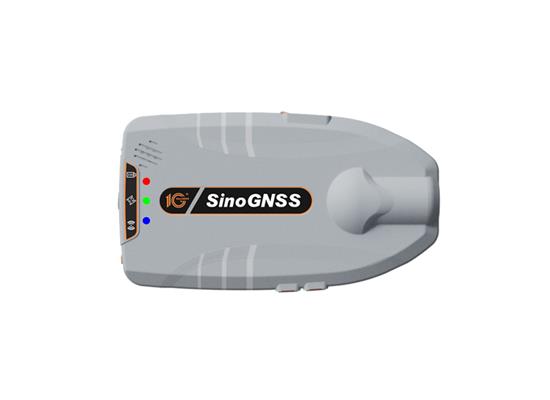
ComNav Technology has released the Z30, a portable high precision GNSS receiver. This device combines a host of advanced features into a compact, versatile design that makes it suitable for a wide range of industries such as personnel positioning, internet of things (IoT), railway patrols, vehicle tracking, and search and rescue missions.
Equipped with the SinoGNSS K8 platform, the Z30 can track full constellations and multiple frequencies, providing centimeter-level accuracy. With 965 channels, it is capable of tracking more than 60 satellites of GPS, BeiDou, GLONASS, Galileo, QZSS, IRNSS and SBAS.
The Z30 features an integrated antenna for stable signal reception. The device is also equipped with two side buttons for power and one-click SOS alerts and three Indicator LEDs for power, satellite, and differential status checks.
It supports NTRIP and TCP protocols, enabling various personnel positioning applications by uploading position data. The Z30 integrates with NaviCloud, offering functions such as real time location display, historical trajectory query, remote control and electric fence. In addition, it can be customized to meet specific customer requirements.
With indoor and outdoor positioning capabilities, the Z30 is a suitable solution for various fields. It supports outdoor real-time kinematic positioning with centimeter-level accuracy and indoor Bluetooth positioning with sub-meter-level accuracy.
GPS World Editor-in-Chief, Matteo Luccio, stopped by the OxTS booth to check out its latest release, the xRED3000, which made its debut at INTERGEO 2023.
Fifty years since it was designed and approved by the U.S. Department of Defense (DOD), the GPS is at risk of losing its status as the world’s gold-standard location service, reported The Wall Street Journal.
In a recent paper published by Harvard’s Belfer Center for Science and International Affairs, “China’s BeiDou: New Dimensions of Great Power Competition,” Sarah Sewall, executive vice president for strategic issues at IQT and co-authors Tyler Vandenburg and Kaj Malden outline their finding that China’s version of GPS is part of the country’s longstanding effort to join the technological ranks of leading nations and use its capabilities to achieve geopolitical advantage across the globe.
Sewall’s assessment of BeiDou’s technical superiority received some unexpected support from a government advisory board on GPS, which stated that “GPS’s capabilities are now substantially inferior to those of China’s BeiDou,” and urged the administration to regain U.S. leadership in the field.
The BeiDou constellation is newer and has more satellites than any other system and has more than ten times as many monitoring stations around the world than GPS does. As a result, BeiDou’s accuracy is much better in many places, including the developing world.
Sewall points out that in cases where BeiDou provides the most accurate positioning, navigation, and timing (PNT) data, particularly in the global south, China may be able to influence other nations’ economies, stating that it is one example of “a new form of great power competition that most in the U.S. government don’t recognize.” China is providing superior PNT information to enhance its diplomatic, economic and military power and the United States cannot afford to cede this area of longstanding advantage.
BeiDou being newer and more advanced than other GNSS, makes it easier for China to encourage other nations to use its signals and purchase specialized equipment, especially when equipment purchases are heavily subsidized by the Chinese government, harming the U.S. economy and its status as the leader of GNSS technology.
Recent launch and surveillance fears
On May 16, 2023, China launched its most recent BeiDou satellite to replenish the constellation, bringing its total to 56 satellites, nearly twice as many as the 31 GPS satellites.
The latest BeiDou satellites also feature two-way messaging, a feature that GPS does not have. It is mainly available in China and requires special chips that are not widely available in the consumer market. It enables users to send short messages in areas without ground network cell coverage and can be used for search and rescue operations.
The CNBC report noted the fear that, with its most recent enhancements, the BeiDou system could be used as a surveillance device — as the two-way messaging feature reveals a user’s locations as well as other types of data.
Additionally, with the growing number of applications for cellphones and an increase in autonomous vehicles that use the BeiDou system, more and more user data is being transmitted.
The U.S. military is upgrading GPS with more-modern satellites that are designed to give nonmilitary devices more-precise coordinates in more indoor and hard-to-reach spaces. However, the next-generation GPS service for civilians is not expected to be released for several years.
GPS pioneered the PNT industry by offering civilians a new, free-to-use system. While originally developed for DOD, it turned into a critical global infrastructure that underlies a vast swath of the U.S. economy.
Besides GPS and BeiDou, there are two other global navigation satellite systems (GNSS), Russia’s Glonass and the European Union’s Galileo, as well as regional systems from Japan (QZSS) and India (NavIc).
BeiDou, once a small regional network with clunky receivers and few civilian users, has grown significantly since launching its first two satellites in 2000. It now has more than 30 precision-enhancing monitoring stations and claims to pinpoint users’ locations to within several centimeters, along with offering basic two-way communication capabilities.
Both BeiDou and GPS offer a variety of nonmilitary benefits that expand beyond the systems’ original expectations, from Uber drivers who often rely on a smartphones GNSS data to locate customers to farmers who can use GPS-based applications for farm planning, field mapping, solid sampling and more. GPS has been called “the silent utility” because signals are used in almost every technology, said Dana Goward, president of the Resilient Navigation and Timing Foundation.
Looking forward
GPS guides U.S. missiles, ships and troops through more-secure military frequencies kept separate from its civilian signals. Its past dominance even made rival militaries reliant on the Pentagon-controlled system.
The U.S. military has long planned to upgrade GPS with a fleet of modernized and upgradable satellites that provide more-precise coordinates subject to less interference. The newer satellites broadcast data to civilian users over a new frequency called L5.
The Space Force has 17 L5-equipped satellites in orbit after a series of delays but has yet to reach the 24 live satellites needed to run a reliable system. Some already-built satellites sit in a Colorado warehouse awaiting their turn for a funded launch.
The Space Force said in a statement that GPS continues to set the gold standard in its field.
“While other nations may report improvements in accuracy and equivalent performance in availability, GPS is still the clear leader in integrity and is the only system accepted for international flight use,” a spokeswoman for the branch’s Space Systems Command told The Wall Street Journal.
“Regarding augmentation services such as Galileo HAS, at what accuracy level should public services end and private ones begin?”
Michael Swiek
“This reminds me of the questions that arose many years ago over whether the U.S. Coast Guard differential correction service (DGPS) would unfairly compete with commercially provided augmentations. I don’t know whether there is a single rigid number that fairly separates publicly provided augmentations from commercially provided ones, or if such a number could be set for all time. It would probably need to be flexible, and evolve over time as needs change and technological improvements come to pass. In the end, the public-provided service should be at a reasonable minimum level to address an identifiable broad public need — such as safety of life requirements — but not so fine as to undercut finer levels of accuracy for which there is a market of users willing to pay for such services from the private sector. This could ensure a responsible service provision for the public good, as well as a healthy competitive environment for commercial technological development.”
Skydio has released the Skydio Remote Flight Deck, a new feature that allows remote control of Skydio X10 UAVs through a web browser over cellular networks. The remote flight deck offers an easy transition of flight control between local and remote pilots to continuous situational awareness via live streaming.
This solution allows operators to command UAVs from either indoors or outdoors, which can benefit public safety, utilities, construction, and transportation sectors.
When rapid response is crucial — such as in law enforcement activities, search and rescue operations or firefighting — UAVs can offer faster, more effective reactions. They can expedite infrastructure assessments, assist in determining recovery priority levels and ensure community safety.
The Skydio Remote Flight Deck allows for faster UAV deployment compared to traditional emergency response vehicles. In potentially dangerous scenarios, a ground officer can delegate flight control to a remote pilot, ensuring localized situational awareness.
Matteo Luccio, editor-in-chief of GPS World, met with Andrew Scott, head of marketing and sales, JAVAD GNSS, to discuss INTERGEO 2023 and what to expect next from the company. Watch this exclusive interview and more from INTERGEO 2023.
Point One Navigation has joined the STMicroelectronics Partner Program. The program aims to deliver reliable navigation and positioning solutions to a diverse spectrum of ST customers in the U.S. and Western Europe.
Because of Point One’s navigation software and real-time kinematic (RTK) network, developers using ST Teseo GNSS solutions now have a more efficient path to create precise navigation solutions in industries such as agriculture, construction, last-mile delivery, and autonomous vehicles.
Point One’s Polaris Cloud is a GNSS correction network that enables GPS based localization, while allowing users to choose the performance and price point that best fits their application. With coverage across the U.S. and most of Western Europe, Polaris Cloud provides a readily available solution for precise localization.
FusionEngine software, developed by Point One, further enhances precision navigation by integrating additional sensors like IMUs and wheel speed sensors. This allows users to achieve a desired level of accuracy, even in situations where satellite signals are absent or in challenging urban environments. The software also offers automatic calibration, fault detection and compatibility with a range of host processors.
GNSS is like opium. Highly addictive, pleasing to the user, but laced with peril when you’re hooked. GPS World readers are well aware of the vulnerabilities, and probably aware of the serious concerns governmental bodies have about our reliance upon it. Here, we consider not so much how it can fail as what the impact of failure is on society, and what mitigations exist to minimize those impacts.
Impact on society
The most commonly cited causes of GNSS failure are jamming (unintentional and intentional) and spoofing. Less well appreciated are solar weather, satellite system errors, receiver system errors and, most importantly, cybersecurity-related errors. Any of these can cause a significant disruption to how society functions today.
The U.S. Department of Homeland Security identified that 15 out of the 18 Critical National Infrastructure sectors were vulnerable to GNSS failure: communications, emergency services, information technology, banking and finance, healthcare and public health, energy (electric, oil and gas), nuclear, dams, chemical, critical manufacturing, defense industrial base, postal and shipping, transportation, government facilities, and commercial facilities.
The threat is real and present. Conflicted areas are routinely jammed and spoofed. Even in peace, GNSS is fragile. In the past year, GNSS interference led to a runway at DFW airport being closed, a 33-hour GNSS outage in the Denver metro area, and even a recent Melbourne Formula One race had to be stopped for 40 minutes due to GNSS data problems.
Mitigations
In most cases, no alternate references are in place, and without them, it is difficult to know that the GNSS data being received is wrong. The ship Stena Impero, for example, was seized by Iran for being in its territorial waters. It is thought to have been victim to spoofing that led it there, but proving it is difficult.
Alternate references exist at low cost, but they generally divide “PNT” into “PN” and “T”, and whether on land, at sea or in the air. On land, most requirements are related to “T” because most applications, such as broadcast facilities and data centers, don’t move, and even when they do, there are enough landmarks available to at least make a sanity check. At sea and in the air, by contrast, motion is the reason we are there, there are few landmarks to confirm location, hence “PN” dominates.
For “T”, armageddon clocks can provide holdover for brief interruptions. However, they must be sufficiently tested to ensure that they succeed. In the Denver incident, radio systems had rubidium clocks for backup, but they drifted too far during the outage to be useable, whereas cellular networks, with alternate terrestrial timing sources, continued to work. Terrestrial time distribution systems over existing IP infrastructure, which Hoptroff supplies, work well globally, but are restricted to land-based time synchronization applications.
For “PN” and “T”, in air, sea and land, low-Earth orbit satellite services such as Satelles, Starlink and OneWeb provide global solutions. Their signals are much stronger than GNSS and therefore are much harder to jam or spoof, but they remain susceptible to interferences such as space weather, which destroyed 40 Starlink satellites on launch last year. However, as the Denver incident shows, until you test the solution, you never really know what might go wrong. eLoran terrestrial wireless solutions are very effective but limited in reach to within a few thousand miles of terrestrial transmitters. Such systems are being installed in South Korea and Saudi Arabia due to their proximity to hostile neighbors. They are likely to be installed in North America and Europe within the next decade.
What all these solutions have in common is that, while they are not expensive, they are not free, and are only available under license. Sovereign GNSS providers have, to date, provided PNT signals at no cost to the consumer. It must be accepted in the new landscape, not just that PNT is no longer free, but also that the supplier can choose its customers. Sovereign GNSS access could be restricted at the whim of a president. Private services are already selective — Starlink chose to provide the Ukraine with service during the current conflict, but it has no obligation to continue to do so.
Get on with the risk register
One of the biggest problems with preparing alternatives to GNSS is that the risk is ignored until it has started to have an impact on business and society. This can be addressed by ensuring that resilient PNT is on corporate and institutional risk registers. It is starting to happen now that governments have started to raise concerns. However, we have a way to go before inclusion on risk registers is a foregone conclusion.
FJDynamics has released the Trion P1, a compact handheld lidar scanner and the Trion V10i GNSS system, both with visual positioning. These systems were unveiled at INTERGEO 2023.
Trion P1 lidar scanner
FJD Trion P1 lidar scanner. (Image: FJDynamics)
The simultaneous localization and mapping (SLAM)-based lidar scanner allows users to accurately digitize environments. With the ability to capture indoor, outdoor and underground environments, this compact scanner can be used across a variety of industries such as property management, disaster preparation, forestry and more.
“Our goal at FJDynamics is to bridge the gap between advanced technology and practical applications,” said Mike Zhao, senior product manager. “With the Trion P1 lidar scanner, we’re putting the power of reality capture into the hands of both seasoned professionals and those curious about 3D scanning.”
Key features of the scanner include a lidar capacity of 200,000 points per second, and real-time point cloud visualization on mobile devices via Trion Scan. In addition, it can calculate distance, area and volume.
Trion V10i GNSS system with visual positioning
FJD Trion V10i GNSS system with visual positioning. (Image: FJDynamics)
The FJD Trion V10i GNSS System integrates two cameras for vision-guided surveying operations, an inertial measurement unit (IMU) for tilt surveys and an OLED screen for easy status checks. This technology is designed to enhance productivity in the field, even in hard-to-access locations.
The technology features IMU-based tilt compensation for precise measurements of up to 60 ° with no calibration needed. It also comes with a built-in 4G LTE and UHF and supports NFC, WiFi and Bluetooth. It also offers users seamless connectivity through Trion Survey Cloud for real-time data sharing between field and office teams.
Ligado Networks has sued the U.S. federal government for $39 billion, alleging officials at the U.S. Department of Defense (DoD) misappropriated Ligado’s exclusively licensed L-band spectrum to support secret DoD systems without permission or compensation.
“The lawsuit, filed in the U.S. Court of Federal Claims against the United States, the Defense Department, the Commerce Department and NTIA, seeks just compensation for the government’s physical, categorical, regulatory and legislative takings of Ligado’s property,” the company said in a press release.
According to the company’s lawsuit, the DoD embarked on a “misinformation and disparagement campaign” against Ligado starting shortly after the company received its FCC approvals in 2020. That campaign, according to the lawsuit, sought to revive concerns that Ligado’s 5G plans would interfere with GPS services.
Ligado alleges the DoD’s claims about spectrum interference “are a pretext” to conceal secret Pentagon systems that depend on Ligado’s spectrum.
The company claims multiple former and current senior government officials have acknowledged the DoD wants Ligado’s spectrum for its own, undisclosed purposes, and that the DoD’s activities cannot co-exist with Ligado’s authorized use of its spectrum.
“High ranking U.S. government officials have acted deliberately to deprive an American company of its rightfully licensed property,” said Ivan Seidenberg, chairman of Ligado’s board of managers.
Its complaint states the DoD, U.S. Department of Commerce (DoC) and the National Telecommunications and Information Administration (NTIA) have deprived Ligado of all the economic benefits it could have expected from using and developing its exclusively allocated and licensed spectrum for terrestrial services.
Ligado is asking the court for “just compensation in an amount to be determined at trial for its past, present, and future taking of Ligado’s rights.”
SpaceX has signed a deal to launch four of Europe’s flagship navigation and secure communications satellites into orbit, reported The Wall Street Journal. The European Commission and the European Union (EU) member states have yet to give a final approval for the deal, the report added.
SpaceX and the European Space Agency recently signed an agreement for two launches next year, each carrying two Galileo satellites.
The deal states the satellites will be launched from the U.S. on SpaceX’s Falcon 9 rocket.
European space officials said last month they face crucial timing decisions in the coming weeks on the return to flight of Europe’s flagship space launchers following a series of delays.