CNH Industrial has completed its purchase of the global satellite navigation technology company Hemisphere GNSS for a total consideration of USD $175 million.
The acquisition, first announced in March 2023, is said to strengthen CNH’s capabilities in precision, automation, and autonomy technology. It also furthers the company’s efforts in vertical integration to provide cutting-edge technology to customer fleets.
With Hemisphere’s expertise and network, CNH says that it can accelerate its strategic plan to develop its automation technology, expedite the delivery of a fully autonomous farming cycle, and extend and enhance automation and autonomy across a broad range of construction applications.
“Bringing Hemisphere’s talent and resources into CNH reflects the energy and momentum of our investments in tech innovation,” said Marc Kermisch, Chief Digital & Information Officer at CNH. “From 2024 onwards, we will bring notable value to customers through significant advancements in our journey from automating certain tasks to fully autonomous operation.”
This year marks 50 years since the U.S. Department of Defense approved the design for GPS and first funded the program. It is also the 30-year anniversary of an important milestone – initial operational capability of GPS. Please don’t let its longevity fool you into thinking it is past its prime! GPS is, and will remain, one of the most innovative systems ever designed, funded and operated by the U.S. government.
Today, GPS represents a highly successful public and private partnership, one in which diverse stakeholders continue to coordinate through fora such as the National Executive Committee for PNT and its Advisory Board. and the Civil GPS Service Interface Committee. How did this system become a military, public safety, critical infrastructure, and economic success? The world-class GPS community is made up of the teams and individuals who design, develop and operate these critical technologies as well as the people and organizations that benefit from its applications. From pioneers, scientists, engineers, and Guardians to civil servants, lawmakers, and entrepreneurs, the GPS community has transformed, is transforming, and will continue to transform lives across the globe, and soon, the moon.
GPS World highlighted the important roles played by many early GPS pioneers in a two-part series aptly titled, “Heroes” in the May and June 2010 issues. It has also covered Dr. Gladys West, who is one of the most consequential mathematicians and programmers to contribute to the global success of GPS. Her geodetic models helped refine our understanding of Earth’s shape, which proved fundamental to the success of GPS and its myriad applications. In 2021, the Trimble Foundation established the Dr. Gladys West Scholarship Program. Virginia State University (her alma mater!), North Carolina A&T State University, and Florida International University award four-year scholarships to one student per year to honor Dr. West’s achievements as a woman of science and a woman of color.
A celebration of GPS must also recognize our lawmakers — the people who authorize and appropriate funding for GPS and its augmentation programs. Nearly every U.S. federal department and agency uses these systems to fulfill their missions on behalf of the American people. They also leverage their technical, programmatic, operational, and experiential expertise to ensure that GPS and its augmentation systems remain the best in the world. This work is possible thanks to congressional committees, members of Congress, and staff. The Senate Appropriations and House Appropriations committees, the Senate Armed Services and House Armed Services committees, the Senate Commerce, Science and Transportation and the House Energy and Commerce committees, the GPS Caucus and many more members of Congress, provide critical oversight and funding. Their support ensures that GPS continues to bring $1.7 trillion and counting in economic benefits to the U.S. economy, creating hundreds of thousands of jobs while enhancing national security, public safety and critical infrastructure.
The future is bright for GPS manufacturers and those developing new applications. To realize their success, projects funded by the Infrastructure and Investment Jobs Act and the Inflation Reduction Act will depend on GPS to continue to deliver signals that are accurate, have integrity, and are available and continuous in nature. The next enterprising GPS entrepreneur is waiting in the wings
Thanks to a network of determined individuals, GPS-driven technologies — used to support precision agriculture, safe transportation, synchronized global banking, cutting-edge emergency response, elite and amateur sports, and more — are transforming our lives, creating jobs, and promoting growth across the economy.
GPSIA joins other members of the GPS community by celebrating 50 years of GPS and looks forward to the innovations and applications that will shape the next 50 years and beyond.
Septentrio has introduced two new open-source hardware projects available to integrators of satellite-based positioning.
By expanding their ecosystem of open-source hardware and software, Septentrio aims to make reliable GNSS positioning more accessible to integrators and developers.
The first project, mosaicBus, is a reference design of a board compatible with mikroBUS add-on board standards primarily used in embedded systems. MikroBUS enables easy plug-and-play sensor integration into development boards from major companies such as MikroElektronika, who developed the mikroBUS standard.
The second project, called mosaicAlto, is a carrier board embedding the mosaic-X5 or mosaic-H GNSS receivers, which transforms Arduino Pro Portenta into a single-board computer with a GPS/GNSS receiver.
The mosaicBus board can be used in applications such as automation, robotics or Internet of Things (IoT).
Mosaic is a compact high-precision multi-frequency GPS/GNSS receiver module known for its performance in harsh environments and resilience to jamming and spoofing. The module is designed for systems where accuracy and reliability are required. It has been widely adopted through existing projects such as the mosaicHAT, a shield board for Raspberry Pi and Mowi, a wireless communication board using the mosaic receiver.
In addition to hardware reference designs, Septentrio also supports ROS and several other UAV autopilots.
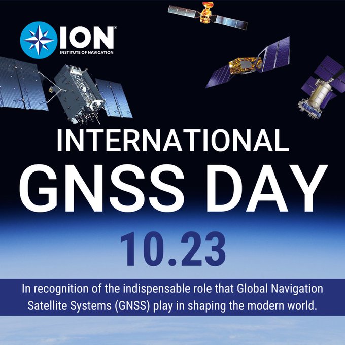
In recognition of the indispensable role GNSS plays in shaping the modern world, the Institute of Navigation (ION) has established “International GNSS Day,” which would occur annually on October 23.
This date, written as 10/23, was chosen in honor of the frequency of 10.23 MHz, the original heartbeat of all GPS satellites, signals and receivers. This frequency was later adopted by all GNSS service providers and serves as the basis of L-band signals for over 100 navigation satellites today.
International GNSS Day aims to highlight the global impact of satellite navigation in diverse sectors, including transportation, agriculture, aviation, surveying and more. It provides a platform to recognize the collaborative efforts of nations, organizations and individuals in advancing GNSS technology. ION pays special tribute to the developers of GPS, celebrating 50 years since its inception this year.
By declaring “International GNSS Day,” ION seeks to raise awareness and appreciation for the critical role GNSS plays in navigating the course of our interconnected world.
Trimble has launched IonoGuard, designed to reduce ionospheric disruptions in positioning and navigation by minimizing performance impacts caused by scintillation or signal noise.
Referred to as solar activity, ionospheric disturbances peak every 11 years. The next major disruption, Solar Cycle 25, is expected to peak between 2024 and 2026. Ionospheric activity can directly impact the quality of GNSS signals, leading to the degradation of position accuracy. While this type of disturbance has the greatest impact on high precision GNSS users operating around equatorial and high latitude regions, global disruptions are possible during the height of the solar cycle.
IonoGuard leverages Trimble’s high-precision receiver hardware design and signal tracking, offering improved positioning performance in challenging environments. This will minimize the probability of a complete loss of GNSS signals and improve the signals’ accuracy and integrity.
For Trimble’s geospatial, civil construction and OEM GNSS receivers supporting the ProPoint GNSS positioning engine, IonoGuard is a free downloadable firmware update expected to be available in late 2023 for receivers under warranty.
Geo Week 2024 is set for Feb. 11-13 at the Colorado Convention Center in Denver, Colorado. This event was created in response to the changing needs of built world and geospatial professionals, and to acknowledge the current convergence of technology.
Geo Week’s conference program and tradeshow floor will feature commercial applications of 3D technologies, innovations and case studies in the built environment, advanced airborne and terrestrial remote sensing solutions, smart products for a full project team and more.
Attendees and exhibitors can register here. The conference schedule can be found here.
Septentrio has partnered with SparkFun Electronics to broaden market reach and the availability of satellite-based positioning products for integrators in a variety of industrial and emerging sectors. As part of the partnership, SparkFun has released its first product, the mosaic-X5 Triband GNSS RTK Breakout board.
The mosaic module is a compact GNSS receiver that delivers high-accuracy tri-band positioning with built-in technology that is resilient to signal interference, including jamming and spoofing. The SparkFun breakout board enables users to log data as well as control and monitor the receiver via the web interface, without the need for additional code.
The mosaic-X5 Triband GNSS RTK Breakout is now available for purchase via the SparkFun website.
Position Partners has entered an agreement to partner with Teleo, a U.S. based company building autonomous technology for heavy equipment. Under the agreement, Position Partners will offer the full Teleo remote-operated and autonomous solutions across Australia, New Zealand and Southeast Asia.
Teleo’s system can be modified to any make and model of machine and includes the company’s proprietary software, a remote command center to operate the equipment, and a mesh network to enable two-way communication between the command center and machines.
The system incorporates sensors, including high dynamic range cameras that deliver high-definition visibility and video footage both day and night.
Once Teleo’s technology is integrated, users can control multiple machines, at multiple sites, from a single station.
“With ongoing labour and skills shortages in the construction sector, there is more work to be done than there are people to do it,” Position Partners CEO Martin Nix said.
Position Partners will offer the full Teleo solution to customers and support sales, installation and training in all countries in which the company operates including Australia, New Zealand, Singapore, Indonesia, Malaysia and the Philippines.
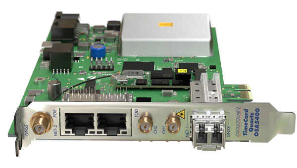
Adtran’s OSA 5400 TimeCard has obtained approval from the Open Compute Project (OCP) Time Appliance Project (TAP) for data center timing and synchronization. The plug-in device integrates Adtran’s Oscilloquartz timing technology into any white box server, aiming to solve key challenges in the transition to virtualized environments.
The OSA 5400 TimeCard facilitates smooth and efficient operations for critical and time-sensitive applications. The card’s compact design, scalability and advanced features make it ideal for data center operators looking to adopt open, disaggregated hardware, the company said.
In combination with Adtran’s Ensemble Sync Director, the timecard offers operational teams a comprehensive, unified view of their entire timing infrastructure. Additionally, the OSA 5400 TimeCard has been developed to fully align with the IEEE P3335 standardization. The inclusion of high-performance quartz and rubidium oscillators ensures accurate timing during extended GNSS disturbances.
The OSA 5400 TimeCard can be integrated into available PCIe slots of standard servers or PCs.
TRX Systems has announced it is now shipping the Dismounted Assured Positioning, Navigation, and Timing (PNT) System Generation II (DAPS GEN II) solution to the United States Army. The device provides assured PNT to warfighters operating in GPS-denied environments.
In March, the U.S. Army Program Executive Office for Intelligence, Electronic Warfare and Sensors awarded TRX a seven-year, $402 million contract to deliver the DAPS GEN II systems.
TRX DAPS GEN II is a small, handheld device that features efficient power utilization algorithms that enable a continuous stream of assured PNT data for warfighters and their combat systems. To achieve this, the device fuses inputs from a diverse range of PNT sources including M-code GPS, a secure and higher-powered military GPS capability that is resilient against jamming and other threats, complementary sources of position and time data when GPS is degraded, and inertial sensors supporting integrity and positioning, independent of any satellite source.
The TRX DAPS II system is available for purchase by U.S. government entities. Distribution to U.S. allies is restricted to approved cases in the Foreign Military Sales Program.
The United Kingdom’s Minister for Science, Research, Innovation announced in Parliament today a 10 point “policy framework” for advancing positioning, navigation, and timing (PNT).
The announcement addressed improvements to both PNT technology and policy.
Six technology efforts were listed:
“National Timing Centre: develop a proposal for a National Timing Centre (NTC) to provide resilient, terrestrial, sovereign, and high-quality timing for the UK (UTC(NPL)), including sovereign components and optical clocks.” This project has been underway for some time and is being executed by the UK’s National Physical Laboratory. The announcement said another £14 million had been identified and was being allocated to the project.
“MOD Time: develop a proposal for ‘MOD Time’ creating deeper resilience through a system of last resort and use NTC provided timing to support MOD.”
“eLORAN: develop a proposal for a resilient, terrestrial, and sovereign Enhanced Long-Range Navigation (eLORAN) system to provide backup position and navigation.” In May, the UK’s spectrum office, Ofcom, sought interest from industry in obtaining eLoran broadcast licenses. The U.S. Department of Transportation issued a similar request for information this month.
“UK SBAS: develop a proposal for a UK Precise Point Positioning Satellite-Based Augmentation System (SBAS-PPP) to replace the UK’s use of the European Geostationary Navigation Overlay Service (EGNOS), monitor GNSS and enable GNSS-dependent high accuracy position for autonomous and precision uses.” Since Brexit, the UK has not been a part of the EU’s Galileo enterprise. This SBAS decision comes after the UK government researched and rejected the idea of establishing its own GNSS.
“Next Generation PNT: deploy existing R&D funding into a UK Quantum Navigator and investigate possible options for a UK sovereign regional satellite system.” Britain has made development of quantum capabilities, including PNT, a particular national focus.
“Infrastructure Resilience: rollout resilient GNSS receiver chips, develop holdover clocks, and consider options for legislation on CNI sectors to require minimum resilient PNT.” The U.S. Executive Order 13905 points in a similar direction as this idea for legislation, which is a good segway to the announcement’s policy provisions.
Four organizational and policy initiatives included in today’s statement in Parliament:
“National PNT Office: establish a National PNT Office in the Department of Science, Innovation and Technology to improve resilience and drive growth with responsibility for PNT policy, coordination, and delivery.” Last year the Resilient Navigation and Timing Foundation reported a cross-government office had been established by the UK that included representation from the Ministry of Defence. That office was within the Department for Business, Energy & Industrial Strategy (BEIS). Since then, BEIS has been split into two departments, one of which is Science, Innovation, and Technology.
“PNT Crisis Plan: retain and update a cross-government PNT crisis plan to be activated if GNSS-provided PNT is lost and identify and implement short term mitigations.” Similar plans exist in the United States. The absence of an interference detection and monitoring system, though, has helped stymie U.S. government efforts to respond quickly and effectively.
“PNT Skills: explore options for centers for doctoral training in timing and PNT and review PNT skills, education, and training for longterm sovereign PNT capability.” A similar need has been identified by the U.S. President’s National Space-based PNT Advisory Board.
“Growth Policy: develop a PNT growth policy, including R&D programs, standards and testing, to drive innovation for PNT based productivity.” The U.S. PNT R&D Plan is a similar effort.
Also mentioned in the statement to parliament are two new PNT documents published today by the UK Space Agency. The first is a summary of technical concepts developed under the Space Based PNT Programme. The second is an updated report on the economic impact to the UK of a disruption to GNSS.
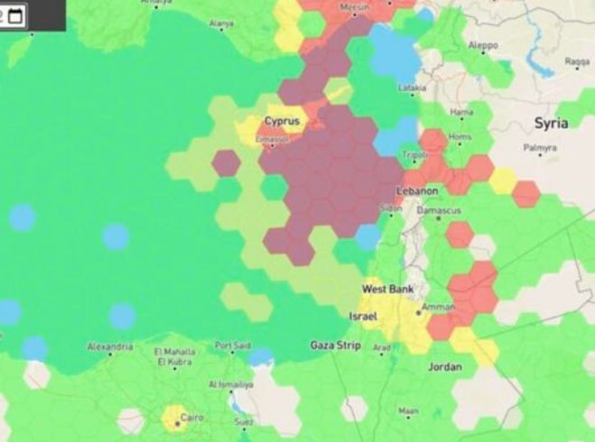
Just as I was beginning to write this article, war broke out between Israel and terrorist forces in Gaza. It would seem that the rockets used by Gaza were aimed rather than carrying on-board guidance, while Israeli airforce bomb/rocket attacks have been carried out with some degree of precision. Nevertheless, jamming in Israel may still be relevant to the ongoing conflict and any on-going commercial aircraft activity. However, it seems from the diagram of jamming below, that the Gaza strip is virtually interference free.
One of the things you can be sure of in the Ukraine-Russia war is that one side or the other is jamming the other’s communications and sat-nav guidance systems. An apparent consequence is that there is likely some “spill-over” to adjacent areas. For Israel, however, it looks like it’s more directed jamming rather than incidental.
Israel GPS jamming. (Image: GPS Jam.org)
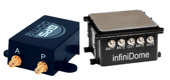
In this environment of intentional GPS jamming, it’s not surprising that Israel has produced a leading anti-jam technology company, called InfiniDome, in Caesarea (between Haifa and Tel-Aviv). According to co-founder Omer Sharar, the company has been working to defend GPS signals for more than seven years and has also seen the rise of devices to jam the GPS L1 frequency that anyone can buy online for $100.
Just as Ukraine is throwing explosive cardboard UAVs with little cost at Russian occupying forces, a few carefully placed low-cost jammers could inflict serious damage on a country’s navigation capabilities.
However, a 2019 presentation by Todd Humphreys identified the source of interference and spoofing at that time, a Russian high-power jammer located at a Russian base in Syria.
Humphreys used instrumentation on the International Space Station (ISS) to gather data on the directed interference but concluded that the jamming in Israel could be a consequence of Russia’s efforts to protect its troops in Syria from UAV attacks. The Russian Khmeimim Air Base is on the Mediterranean coast and attacks are thought to come from rebels within Syria.
With the current GPS jamming out of Syria, most commercial aircraft traffic flying into Ben Gurion International Airport is significantly affected as flights cross from over the coast from the Mediterranean. Longer flight tracks deeper southeast into Israel are necessary, probably relying on VOR and DME ground station waypoints before turning back northwest to capture the instrument landing system (ILS) into the airport. This costs time and fuel and causes aircraft to overfly settlements where noise can be a real problem.
Most readily available jammer electronics only output interference disrupting GPS L1, which is most commonly installed for vehicle tracking and UAV guidance. InfiniDome has successfully protected trucking, UAV operations and others in Israel and around the world with its Infinidome GPSdome-1 and GPSdome-2 anti-jam products.
Two antennas 10 cm to 25 cm apart enable GPSDome-1 algorithms to detect and null out a GPS L1 jammer. GPSDome-2 accommodates up to four antennas and can null up to three directional signals on both GPS L1 and L2 or GPS L1 and GLONASS L1.
InfiniDome is currently working with an aerospace company to integrate its anti-jam technology with airborne inertial/GPS and qualify the integrated system for use in civil aviation, with the objective of maintaining max 3% drift when fully jammed. This will introduce certified anti-jam technology into civil aviation use — something that will provide some jamming protection, which airlines desperately need going forward. In addition, other high-end UAV manufacturers are potential customers for this new system.
While the ongoing conflict and the devastating loss of life is forefront as each day of the war passes, these anti-jam solutions may ultimately help solve signal degradation problems. While there is going to be a significant impact on commercial airline travel to and from Israel while hostilities continue, we can maybe see the way to a possible long-term solution for the intense jamming from which the region has suffered for many years.