
GPS World Editor-in-Chief, Matteo Luccio, met with Marcel Visser, CEO of NavCert, at INTERGEO 2023 to discuss the company’s new C3 certification.
Blog
-

INTERGEO 2023: SBG Systems
Florian Ollier, head of marketing and communications, SBG Systems, talks about the company’s new releases and more from INTERGEO 2023.
-

Exclusive interview with US DOT
 In September, the U.S. Department of Transportation (DOT) released the Complementary PNT Action Plan: DOT Actions to Drive CPNT Adoption. On October 16, Matteo Luccio asked a few questions about the plan to Karen Van Dyke, Director for Positioning, Navigation, and Timing (PNT) and Spectrum Management in the U.S. Department of Transportation’s Office of the Assistant Secretary for Research and Technology (OST-R). Below are Luccio’s questions and Van Dyke’s responses.
What is your office’s charter within the federal government to advance the development and deployment of complementary PNT?
The U.S. Department of Transportation (DOT) is the lead for civil PNT requirements in the United States and represents the Federal civil departments and agencies in the development, acquisition, management, and operations of GPS. The DOT Positioning, Navigation, and Timing (PNT) and Spectrum Management program (within the Office of the Assistant Secretary for Research and Technology) coordinates the development of Departmental positions on PNT and spectrum policy to ensure safety, mobility, and efficiency of the transportation network. The Department also provides civil PNT system policy analysis and coordination representing Federal civil agencies responsible for critical infrastructure in the requirements development, acquisition, management, and operations of GPS.
These efforts support Federal policy governing PNT programs and activities for national and homeland security, civil, commercial, and scientific purposes. These include Executive Order 13905, Strengthening National Resilience Through Responsible Use of Positioning, Navigation, and Timing Services (EO 13905), and Space Policy Directive 7, The United States Space-Based Positioning, Navigation, and Timing Policy (SPD-7).
Which GPS vulnerabilities and at what scale is this plan addressing?
The DOT Complementary PNT Action Plan addresses disruption, denial, and manipulation of GPS for critical infrastructure sectors. These vulnerabilities of GPS include unintentional and intentional jamming and spoofing (both measurement and data spoofing) of the GPS signal and physically impeded environments in which the availability of the GPS signal is impacted (e.g., indoors, underground, and urban canyons). This plan is intended to address vulnerabilities/limitations of GPS on both a widespread and local scale.
How and when will this action plan move the federal government’s posture on CPNT from study to action?
In 2020, the DOT Volpe National Transportation Systems Center (Volpe Center) conducted field demonstrations of candidate PNT technologies that could offer complementary service in the event of GPS disruptions. The purpose of the demonstrations was to gather information on PNT technologies at a high technology readiness level (TRL) that can work in the absence of GPS.
While this demonstration was a snapshot in time, there were two central recommendations from the demonstration:
- U.S. DOT should develop system requirements for PNT functions that support safety critical services.
- U.S. DOT should develop standards, test procedures, and monitoring capabilities to ensure that PNT services, and the equipage that utilize them, meet the necessary levels of safety and resilience identified in Recommendation 1.
The culmination of the demonstration program was the 2021 Report to Congress, Complementary PNT and GPS Backup Technologies Demonstration Report (2021 Demonstration Report). The PNT resiliency recommendations distilled in the 2021 Demonstration Report were vetted through a Federal interagency review process. During the same period, SPD-7 (directed to U.S. Federal Space-Based PNT service providers) and EO 13905 (directed to PNT users) were issued in a coordinated effort to strengthen U.S. PNT policy.
As part of its ongoing responsibilities as civil PNT lead, the Department has developed a Complementary PNT Action Plan to drive CPNT adoption across the Nation’s transportation system and within other critical infrastructure sectors. The plan describes actions that the DOT plans to pursue over the next several years, including engaging PNT stakeholders; monitoring and supporting the development of CPNT specifications and standards; establishing resources and procedures for CPNT testing and evaluation; and creating a Federal PNT Services Clearinghouse. Taken together with efforts of other Federal partners, these initiatives will continue to strengthen the resilience of the Nation’s PNT-dependent systems, resulting in safer, more secure critical infrastructure.
It should be noted that the U.S. Government is not procuring CPNT systems for non-Federal stakeholders, and as always, all activities are subject to the availability of appropriations.
How does DOT intend to engage PNT stakeholders?
DOT held a PNT Industry roundtable on August 4, 2022 that included representatives from Complementary PNT Technology vendors and critical infrastructure sectors. https://www.transportation.gov/pntindustryround
Feedback from this DOT industry roundtable informed the development of the DOT Complementary PNT Action Plan.
On September 11, 2023, DOT issued a Request for Information (RFI) as one of the steps to drive adoption of Complementary PNT services to augment GPS for the Nation’s transportation system, and through the Executive Branch Interagency Process, for other critical infrastructure sectors. U.S. DOT is planning a resiliency test, evaluation, and performance monitoring strategy for PNT-dependent transportation systems. Taken together with efforts of other Federal partners, these initiatives will strengthen resilience of the Nation’s PNT-dependent systems through the U.S. Government’s purchasing power as a demanding customer of Complementary PNT (CPNT) services, along with critical infrastructure owners and operators, resulting in safer, more secure critical infrastructure for the nation.
The DOT Volpe Center issued this RFI seeking information from industry about availability and interest in carrying out a small-scale deployment of very high technical readiness level (Technology Readiness Level (TRL)≥8) CPNT technologies at a field test range to characterize the capabilities and limitations of such technologies to provide PNT information that meet critical infrastructure needs when GPS service is not available and/or degraded due environmental, unintentional, and/or intentional disruptions. This deployment is intended to test these technologies against CI relevant requirements in order to gain confidence in performance and foster user adoption.
It is likely that DOT will hold future industry roundtables with Complementary PNT technology vendors and critical infrastructure sector owners and operators.
-

INTERGEO 2023: ComNav Technology
Simon Peng, director of the international department at ComNav Technology, talks about the company’s new rod-less GNSS receiver and more surveying and mapping antennas featured at the INTERGEO 2023 booth.
-
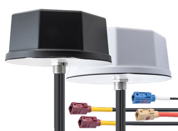
Pasternack introduces IoT multiband antennas
Image: Pasternack Pasternack has launched its new line of IoT multiband combination antennas. Designed for vehicles, fleets and pivotal base stations, the technology aims to revolutionize how industries perceive and use mobile connectivity.
The antennas integrate 4G, 5G, Wi-Fi and GPS bands to offer emergency teams, on-the-move fleets and first responders an unwavering link, even in harsh environments.
Facilitated with both FAKRA and SMA connectors and extended 17-foot cable leads, users can seamlessly integrate the technology. It also has an IP69K rating, certifying it for both indoor and outdoor deployments.
MIMO capabilities improve data transmission speeds and reliability, ensuring consistent high-bandwidth connections. The antenna’s GPS/GNSS component, enhanced with LNA and amplified by a 26 dB gain, offers users improved navigation and tracking precision.
-

INTERGEO 2023: YellowScan
Morgane Selve, head of marketing at YellowScan, talks about the company’s new surveying technology, its target markets, use cases and more from INTERGEO 2023.
-
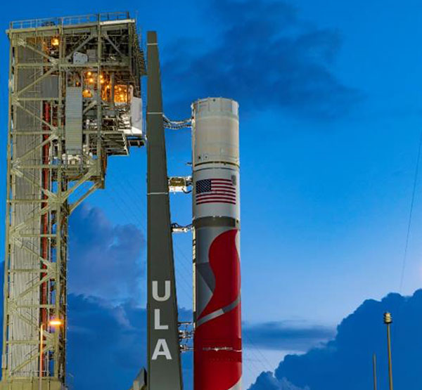
SSC’s 21 new mission assignments include final GPS III mission
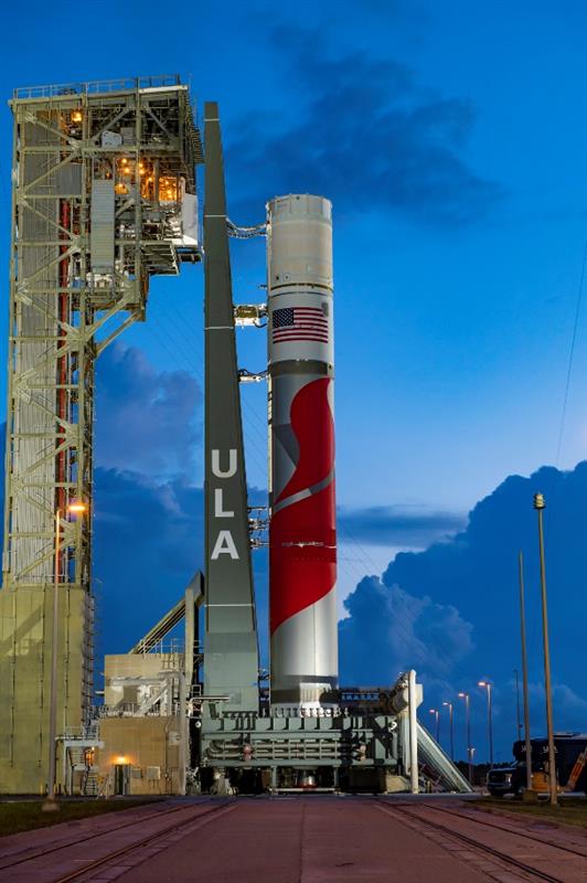
The ULA Vulcan Centaur launch vehicle. (Image: ULA) The United States Space Force’s Space Systems Command (SSC) has assigned 21 launch service mission assignments for the National Security Space Launch (NSSL) Phase 2 Launch Service Procurement contract. This is the fifth and final order year in the Phase 2 contract.
United Launch Alliance (ULA) received 11 mission assignments and SpaceX received 10. These missions are scheduled to launch over the next two to three years and focus on a variety of mission areas.
The 11 missions assigned to ULA are: GPS III-9, NROL-73, NROL-56, STP-5, SILENTBARKER 2/NROL-118, GPS IIIF-1, NROL-100, USSF-95, NROL-109, SDA T2TL-B and USSF-25.
The 10 missions assigned to SpaceX are: SDA T1TL-F, SDA T1TR-A, USSF-57, NROL-77, SDA T1TR-E, GPS III-10, USSF-75, SDA T2TL-A, SDA T2TL-C and USSF-70.
NROL-77, NROL-73, NROL-56, NROL-109, and NROL-100 are missions being conducted in partnership with the National Reconnaissance Office (NRO).
T1TL-F is the last mission of six Space Development Agency (SDA) Tranche 1 Transport Layer launches. T2TL-A, T2TL-B and T2TL-C are the first three Tranche 2 Transport Layer launches. SDA’s Transport Layer aims to provide assured, resilient, low-latency military data and connectivity worldwide to the full range of warfighter platforms.
T1TR-A and T1TR-E are the last two SDA Tranche 1 Tracking Layer launches. The Tracking Layer aims to provide global indications, warning, tracking and targeting of advanced missile threats, including hypersonic missile systems.
The GPS III-9 and GPS III-10 missions are the final projected GPS III missions. The GPS IIIF-1 is the first launch of the follow-on GPS III satellites. GPS Block IIIF introduces several improvements and novel capabilities compared to previous GPS satellite blocks.

SpaceX’s Falcon Heavy launch vehicle. (Image: SpaceX) USSF-57 will launch the first of three next generation overhead persistent infrared GEO satellites. These satellites will deliver survivable, resilient missile warning, tracking, and defense in a highly contested and congested space domain.
SILENTBARKER 2/NROL-118 is a joint NRO and SSC Space Domain Awareness mission to meet U.S. Department of Defense (DOD) and intelligence community space protection needs.
USSF-25 will launch the Defense Advanced Research Projects Agency’s Demonstration Rocket for Agile Cislunar Operations (DRACO). The goal of the DRACO program is to demonstrate nuclear thermal rocket in orbit.
USSF-95 will be the first launch of a missile track custody (MTC) prototype satellite. The MTC prototype effort will evaluate the ability of various next generation overhead persistent infrared sensor designs to meet missile tracking requirements.
STP-5 is the latest mission in support of SSC’s Space Test Program (STP). The STP performs mission design, payload-to-bus integration, space vehicle-to-launch vehicle integration, and on-orbit operations for science and technology payloads that exhibit potential military utility. STP-5 will launch two satellites in support of the DOD’s Strategic Capabilities Office.
-
Federal agencies addressing the geodesy crisis
In my last column, I highlighted the announcement made by the National Geodetic Survey (NGS) of the recipients of the NOAA FY 23 Geospatial Modeling Competition Awards. As shown in the image below, NGS awarded approximately $4 million in grant funding to four institutions for projects that will research emerging problems in the field of geodesy, develop tools and models to advance the modernization of the National Spatial Reference System (NSRS), and help address a nationwide deficiency of geodesists.
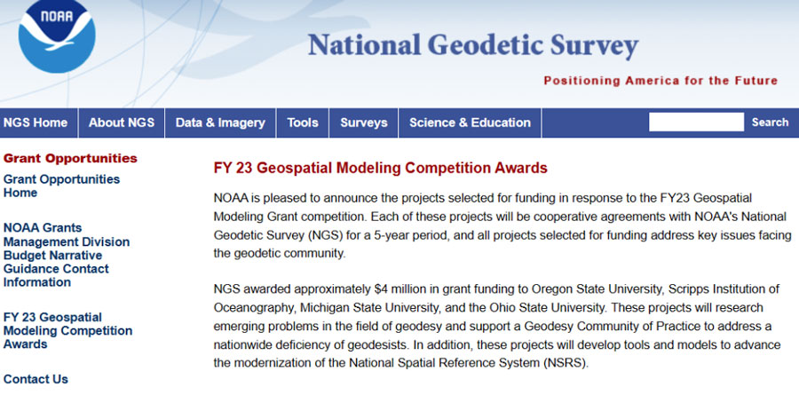
Image: NGS I had the opportunity to speak with Juliana Blackwell, director of the NGS, about the geospatial awards. I asked her how the grants will help NGS in its development of products and services as well as the implementation of the modernized NSRS.
“The geospatial modeling grant is an opportunity to expand our abilities within NGS to address research challenges, diversify the tools we provide, and multiply our future workforce,” Blackwell said. “I’m excited about the competitive and collaborative nature of the grant and the chance for NGS to work with a variety of academic institutions.”
NGS awarded the grant funding to four institutions including Oregon State University, Scripps Institute of Oceanography, Michigan State University, and the Ohio State University. Looking at the summary of the awards, there appears to be some overlapping interest between grantees that could lead to a diverse set of solutions to a problem or task. I will report on specific tasks and outcomes as more details become available.
I was pleased to see that grant proposals included developing new geodetic tools and operating procedures for working with the new, modernized NSRS. Hopefully, these universities will engage the geospatial user community when developing new tools so the tools will be useful during the implementation of the new NSRS.
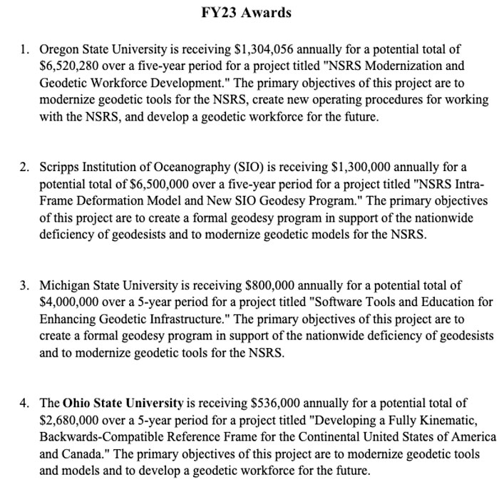
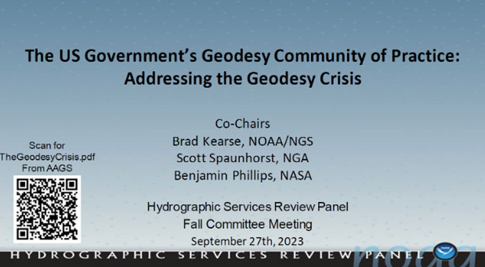
Summary of the Geospatial Awards (Image: NGS) Besides providing funds for the geospatial grants, NGS is collaborating with other federal agencies to address the geodesy crisis. This collaboration, denoted as the “Geodesy Community of Practice (COP),” includes four agencies — NGS, National Geospatial-Intelligence Agency (NGA), National Aeronautics and Space Administration (NASA), and United States Geological Survey (USGS). The co-chairs of the group discussed the group’s actions and goals at the Hydrographic Services Review Panel (HSRP) fall committee meeting held in Silver Spring, Maryland, on Sept. 27-29.
Geodesy Community of Practice. (Image: NOAA’s Hydrographic Services Review Panel) The HSRP involves four NOAA offices: three National Ocean Service (NOS) program offices -NGS, the Center for Operational Oceanographic Products and Services (CO-OPS), the Office of Coast Survey (CS), and the University of New Hampshire’s Joint Hydrographic Center and Center for Coastal and Ocean Mapping. More information and the presentations from the HSRP meeting can be obtained here. The purpose of the committee is to review and provide NOAA with independent advice on their products and services.

(Image: NOAA’s Hydrographic Services Review Panel) I attended the three-day HRSP meeting as a virtual participant. As previously noted, NGS is one of the NOS offices that’s part of the HSRP. As the Director of NGS, Blackwell participated in the 2023 fall HSRP meeting. A majority of the meeting discussed the geodesy crisis. In my opinion, this is due to Blackwell’s efforts to highlight the importance of geodesy to NOAA products and services.
The presentation by the co-chairs of the Geodesy Community of Practice highlighted a few articles that have brought the geodesy crisis to the attention of the geospatial user community. Anyone keeping up with my columns knows that I have been highlighting the geodesy crisis and programs that advance the science of geodesy (July 2020, November 2022, December 2022, and April 2023). The geodesy crisis white paper is posted on the American Association for Geodetic Surveying (AAGS) website.
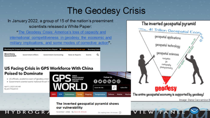
Image: NOAA’s Hydrographic Services Review Panel) The Geodesy COP established working groups to address topics that are important to all geospatial users. All the agencies are supporting the working groups which should help create more effective and efficient solutions to technical geodetic issues.
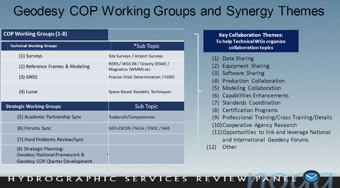
Image: NOAA’s Hydrographic Services Review Panel A goal of the Geodetic Community of Practice is to train future geodesists. The advancements in satellites and computers have enabled geodesy to expand into many different disciplines. Geodetic science and technology now underpin many sciences, large areas of engineering (such as driverless vehicles and UAVs), navigation, precision agriculture, smart cities, and location-based services. Major U.S. companies, such as Google and FedEx, as well as the automobile industry, precision farming companies and mining companies also need more accurate geodetic models, tools, and algorithms. Therefore, these companies also need trained geodesists to perform important research on topics that address their specific geodetic requirements. I highlighted this in my July 20, 2020, GPS World First Fix article. To address the geodesy tradecraft, the COP includes providing professional government assignments. That said, many industries that rely on accurate and consistent geodetic information should also provide professional geodetic assignments.

Training future geodesists. (Image: NOAA’s Hydrographic Services Review Panel) I asked Blackwell how she thought the U.S. government’s Geodesy Community of Practice will help NGS and the geodesy crisis.
“The Geodesy Community of Practice is in the beginning phase right now with the collaboration among federal agencies with geodetic missions, NOAA/NGS, NGA, NASA, and USGS,” Blackwell said. “There is already a benefit in sharing research, workforce, and operational needs and leveraging our resources. I envision expanded engagement with academia, private industry, and other government agencies as the community of practice matures.”
In my opinion, the Geodesy Community of Practice’s integrated working groups consisting of individuals with different backgrounds and skills addressing geospatial problems will help to advance the field of geodesy. I believe that integrated and collaborative organizations create the best geospatial solutions; the Geodesy COP is an embodiment of this concept.
Of course, as I have stated in many of my columns, I like to remind everyone that “geodesy is the foundation for all geospatial products and services.”
-

Seen & heard: Catching crime and tracking songbirds
“Seen & Heard” is a monthly feature of GPS World magazine, traveling the world to capture interesting and unusual news stories involving the GNSS/PNT industry.
Tracking a songbird
Image: YiBaoTY/iStock/Getty Images Plus/Getty Images Researchers in Alaska tracked the migration patterns of olive-sided flycatcher birds by attaching tracking devices to them to discover why their population is declining. The songbirds travel more than 15,000 miles every year to South America and then back to Alaska. To survive the long trips, they require safe locations to rest during their journeys. The researchers believe the stopover sites may provide an answer to the declining population. During the five-year study, the researchers deployed 95 devices and recovered only 17. The data pointed to 13 stopover sites between Washington and Peru as well as their wintering areas in South America.
Crime ring members caught

Image: hdagli/E+/Getty Images Members of an organized crime ring in the Florida Keys who are accused of stealing more than $2.5 million in boating navigation devices have been arrested, reported Local 10.com and Fox 4. Eleven men have been accused of targeting multiple marinas throughout Florida and stealing navigation devices from boats, specifically Garmin devices. For example, a Garmin 8612 H16 Model can be sold for more than $5,000. Ten suspects are in custody and are facing more than 122 charges.
Animals take advantage of COVID-19

Image: DrDjJanek/iStock/Getty Images Plus/Getty Image A new study published in Science used tracking devices on 43 animal species during the 2020 COVID-19 lockdowns to find that wild animals emerged from their natural habitats and ventured closer to the roads and cities that were empty. The study used several methods to analyze tracking data. Researchers examined how much animals moved on an hourly basis and during a 10-day period. Across species and countries, on average, hour-to-hour movement was 12% lower in the spring of 2020 compared to the same period in 2019. With the end of lockdowns, human activity returned to normal, and animals had to adapt again. The results of the study demonstrate how humans can change their own behavior to lessen their impact on animals.
Navigation meets creativity

Image: @vikas_ruparelia on Twitter A man from Bengaluru, India, Vikas Ruparelia, used the Strava navigation app to trace the country of India to celebrate its Independence Day. Ruparelia started and ended his journey at the Mahatma Gandhi statue near Orion Mall in Rajajinagar, India. He covered more than 73 km on foot in 17 hours. The Strava app enables users to track their running and hiking routes as well as join challenges. The route Ruparelia took was designed by another user of the app.
-
DroneShield launches UAV detection technology
Image: DroneShield DroneShield has launched SensorFusionAI (SFAI), a sensor-agnostic, 3D data fusion engine for complex environments.
In a recent release, Angus Bean, DroneShield’s chief technology officer (CTO), emphasized the shift towards a multi-sensor approach for detecting UAVs. He noted this approach is effective for fixed-site, and in some cases, vehicle and ship systems where budgets and space allow.
Bean added that the success of the multi-sensor approach hinges on the presence of an intelligent software engine to fuse the sensor outputs into meaningful data. He said without this crucial component, adding more sensors can lead to information overload without clear management.
In response, DroneShield designed an AI-based sensor fusion engine, initially integrated into its DroneSentry-C2 command-and-control system. This engine accommodates all common UAV detection modalities, including radiofrequency, radar, acoustics and cameras.
SFAI allows third-party C2 manufacturers to integrate SFAI into its C2 systems. This integration can be achieved through a subscription-based software-as-a-service (SaaS) model, enhancing system performance.
Key features of SFAI include behavior analysis to track an object to determine classification and predict trajectory; Threat Assessment that determines threat level based on a range of data types; and an edge processing device called SmartHub for reduced network load and high scalability.
-
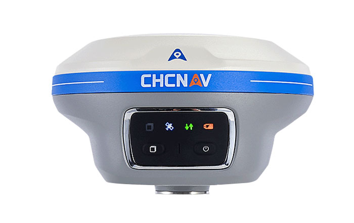
CHCNAV launches IMU-RTK GNSS receiver
Image: CHCNAV CHC Navigation (CHCNAV) has released the i89, a compact IMU-RTK GNSS receiver with visual surveying and 3D modeling capabilities. In addition to GNSS surveying, the i89 offers augmented reality surveying to capture accurate 3D coordinates where signals are obstructed or access is limited.
The i89 combines CHCNAV’s iStar2.0 software and a 1408 channel GNSS system-on-a-chip (SoC) module for full constellation tracking. According to the company, its advanced algorithms improve data quality by 20%, offering RTK accuracy and reliability even in low latitude regions with high ionospheric interference.
Based on video photogrammetry, the i89 dynamically extracts accurate 3D coordinates from real-world video. Coupled with its IMU, it is designed to improve photogrammetry efficiency and accuracy. It complements UAV surveys by resolving typical distortions from UAV-mounted cameras.
The i89 offers 16.5 hours of battery life, weighing only 750g and is IP68-rated to withstand a 2m pole drop. Its visual navigation and staking capabilities aim to simplify field operations and ensure optimal productivity for surveyors in a wide range of everyday surveying tasks.
-

Skydio, Teledyne FLIR enhance uncooled thermal camera UAV payload
Image: Teledyne Flir Skydio has released its X10 UAV, which features a customized Teledyne FLIR Boson+ thermal camera module. As a result of the collaboration, professional public safety and critical infrastructure inspection pilots can now easily access uncooled thermal imaging technology.
The Thermal by FLIR program is a cooperative product development and marketing program. It supports original equipment manufacturers (OEMs), such as Skydio, to integrate Teledyne FLIR thermal camera modules into products.
The Skydio X10 includes a thermal imaging payload using a customized radiometric Boson+ thermal camera module, providing thermal performance and improvements in size, weight, and power (SWaP) that are critical for inspections, situational awareness and search-and-rescue missions.
Thermal performance and SWaP enhancements
The Boson+ provides four times the thermal resolution at 640 x 512 pixels versus the predecessor thermal camera on the Skydio X2. It also doubles the thermal sensitivity of competitive payloads at 30 millikelvin (mK) or more.
Its increased sensitivity and resolution provide users with sharper scene detail, which improves detection, specifically in outdoor, low-contrast scenes — a critical need for thermal inspectors and first responders, including law enforcement officers, firefighters and search-and-rescue personnel.
Teledyne FLIR worked closely with Skydio to develop custom optics to reduce the weight of a standard Boson+ camera optics by 48%, according to the company. The weight reduction aims to help maximize flight time while decreasing the volume of the thermal camera module for an improved payload form factor.
The Skydio X10 has customized thermal image signal processing that leverages Teledyne FLIR’s Prism ISP, further improving imaging quality. The resulting thermal imagery is available as radiometric JPEGs (R-JPEG), meaning each image captured includes temperature data of every pixel in the scene for granular, quantitative insights needed for solar panel, machinery and utility inspection.
That R-JPEG data captured from the X10 can then be combined with the R-JPEG data captured from handheld Teledyne FLIR thermal imaging cameras to create comprehensive inspection reports from the air to the ground.
Skydio X10 users can also use FLIR Thermal Studio software with advanced thermal imaging processing and analysis for creating custom, sharable PDF reports.